A collection of walks, discoveries, insights and pictures of exploring Dartmoor National Park
August 6, 2022
Longstone Mills – Tin Blowing Mill and Corn Mill
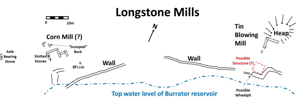
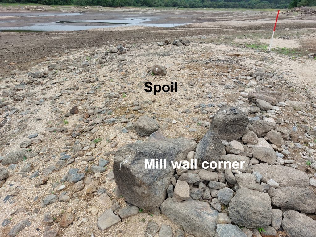
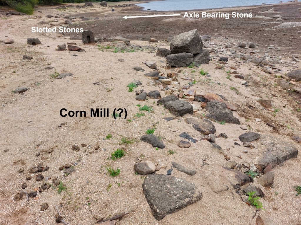
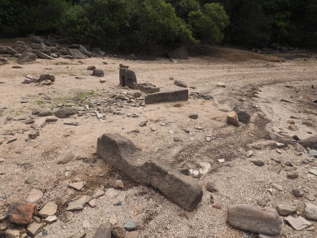
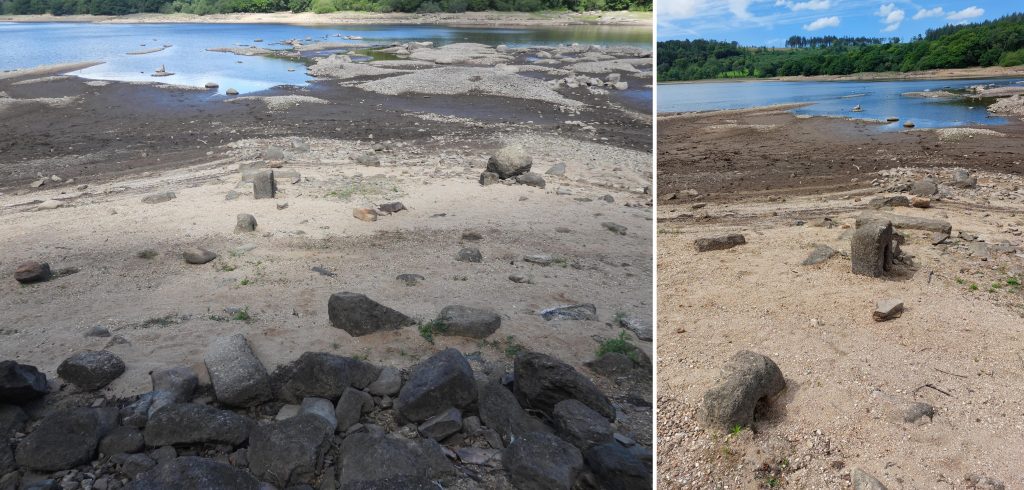
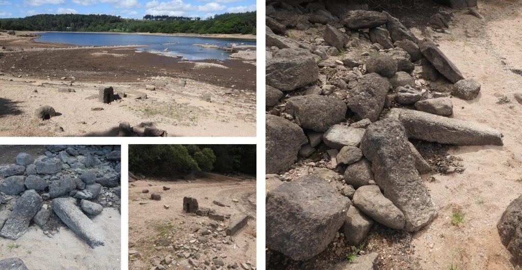
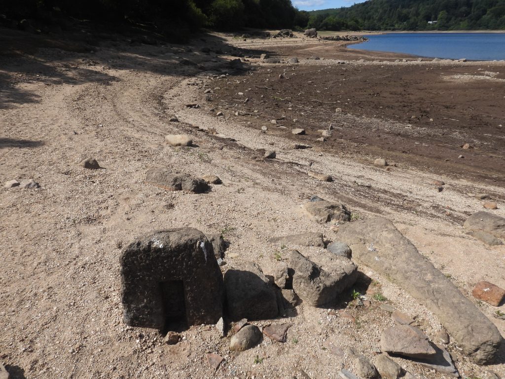
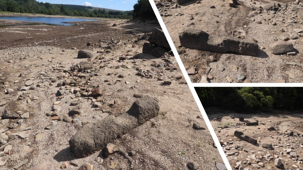
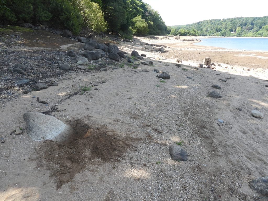
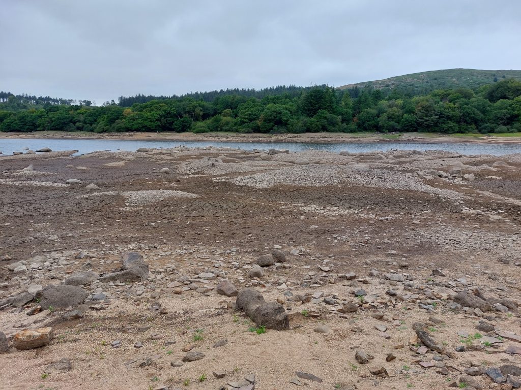
The Longstone Mills comprise (at least two, possible three) ruinous rectangular structures which are located beneath the high water level of Burrator reservoir but are exposed in drought conditions. One structure is recorded as a Tin Blowing Mill and a second is recorded as being a (possible) Corn Mill. The structures are likely to date from early 17th century. Whilst exploring the area, initially very little appears discernible, however, on closer examination there are old walls, two possible mould stones (slotted stones), an axle bearing stone, a (probable) lintel, tin spoil tip with tin slag, a possible wheelpit and a dated inscribed rock which may be of interest to the visitor.
The Dartmoor HER summary (MDV20822) is a little confusing as it implies the dated inscribed rock is next to a Tin Blowing Mill. The author has visited the area several times during the drought in August 2022 and initially believed the structures near the dated inscribed rock was indeed a Tin Blowing Mill. However, “Dartmoor Chris” contacted the author and stated that in the Dartmoor Magazine, Issue 31 (Page 7), there was a sketch plan drawn by Dr Tom Greeves, which suggested the structure near the dated inscribed rock was a (possible) Corn Mill and the Tin Blowing Mill was approx. 70-80m away to the east. Armed with the sketch map, the author along with Chris and Paul Glanville (re) visited the site to pictorially record the features shown on the map. One of the conundrums which we wished to consider was could the two slotted stones near the (possible) Corn Mill be tinners’ mould stones. This would entail measuring the slots and working out how much tin they would have held.
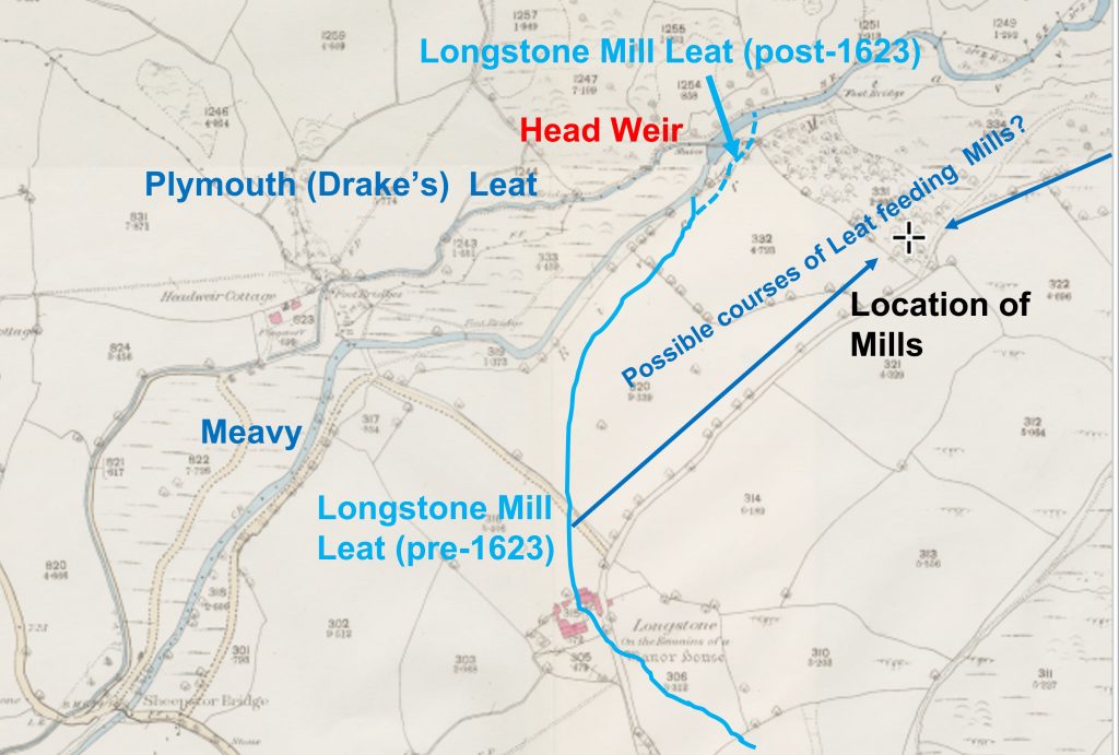
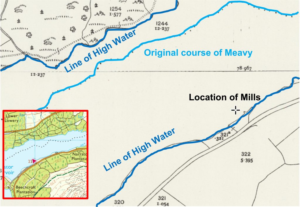
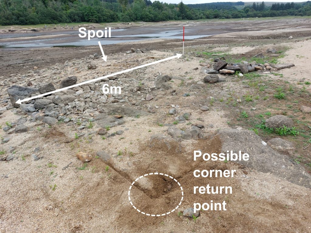
This annotated OS map dates from 1873-1888, just before the reservoir dams were constructed and the reservoir began to fill in 1898. The Tinners’ Mill is located quite close to the original Plymouth Leat Head Weir. The Plymouth Leat was completed in 1591 and it is recorded that a leat was in existence in 1623, and which was diverted from just downstream of the Head Weir to just upstream of it to supplement the Plymouth Leat (Ref: Water from the Moor by David J. Hawkings). Therefore it is possible that the Longstone Mills might have taken its water from this source? If the mills didn’t take its water from this source, it would have most probably come from the Narrator Brook a little further to the north. The Longstone Mill Leat is very long and took its water from the Drizzlecombe Brook. This leat still feeds Ditsworthy Warren House and can be traced to Sheepstor village.The location of the Mills on map from 1892-1914 with the inset being the modern OS map showing the location.The above sketch is based on the Dr Tom Greeves sketch from the Dartmoor Magazine, Issue 31 (page7). The original sketch is dated 27/09/83. This post considers all the features covered in this sketch and considers evidence found on site during the drought of August 2022. Tin Blowing Mill – Carefully scrapping back the surface sand (then backfilling before leaving), a possible additional corner wall was found. From this it was considered what was the orientation of the Mill. No wheelpit evidence was found.
Dartmoor Chris supplied information from the Devon Record Office – Accession DD 1342, viz “Letter of Attorney 1611 Letter dated 23 Sept. 1611 whereby… Windyeat of Dencombe & ….. Windyeat of Middleworthie in parish of Walkhampton co. Devon appoint as their attorneys John Woolcombe gent, & Hugh Stuttaford to enter into parts of certain tin works & to deliver seisin of same to John Elford son & heir apparent of Walter Elford of Shipstorr co. Devon, gent, according to stannary custom & the statute of the stannary of 6 Edw. VI. Consideration money £5 paid by Walter Elford. The tin works in question are: – ……………One-quarter & one-eighth of Longstonebeme…….in jurisdiction of stannary court of Plympton. Witnesses to sealing: William Xlarg, Walter Elford, Ellie Stiphin, Marken Lasetts & John Pearse.”
This record appears to relate to tin mining in the area and there being possibly a Beam or Beme (which was an openwork).
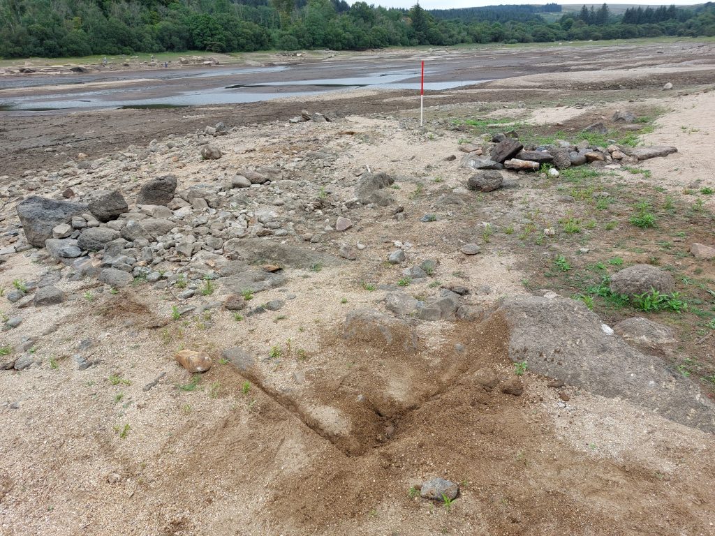
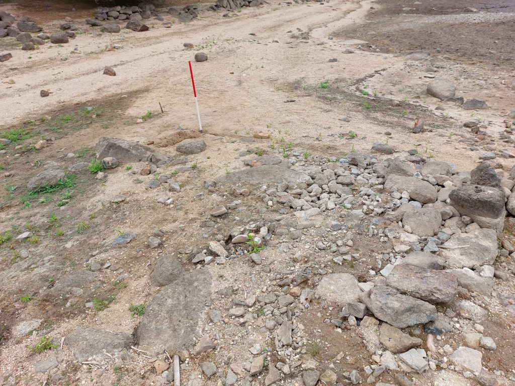
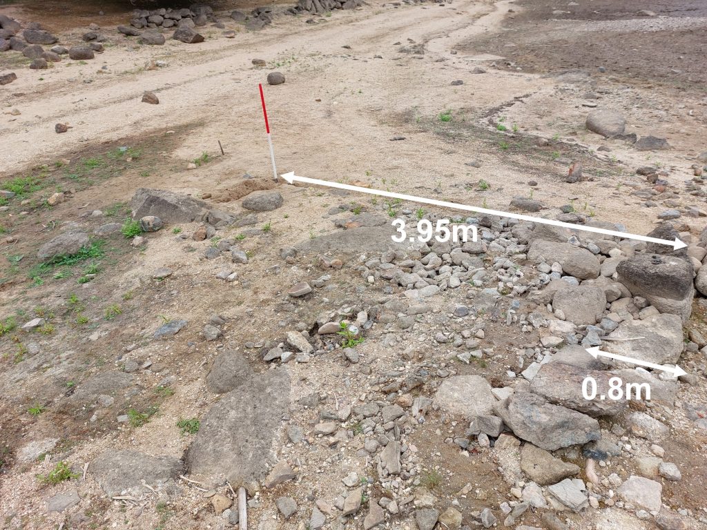
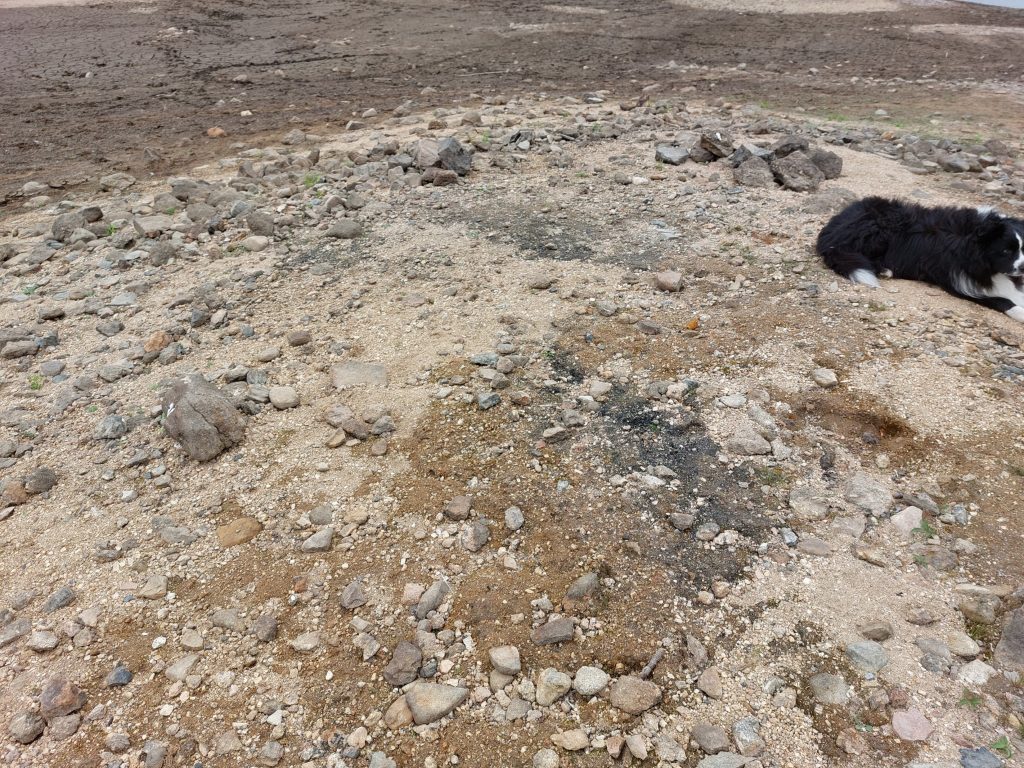
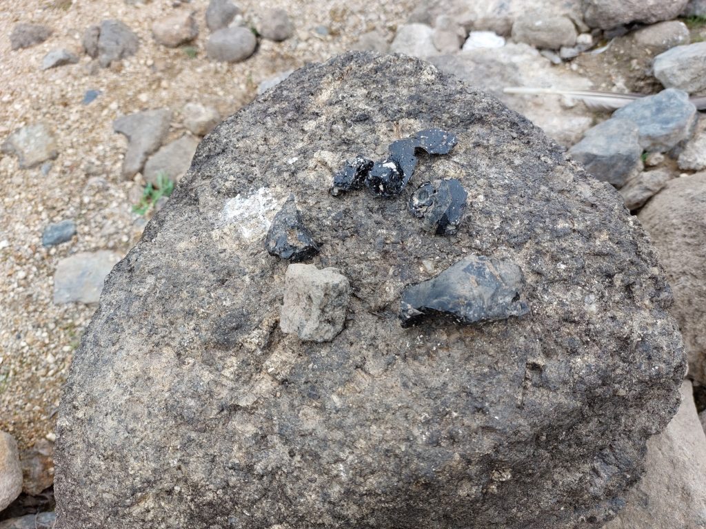
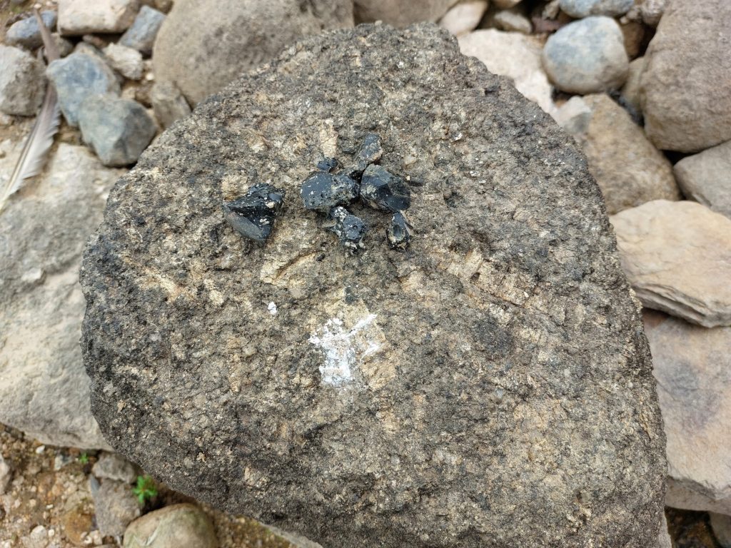
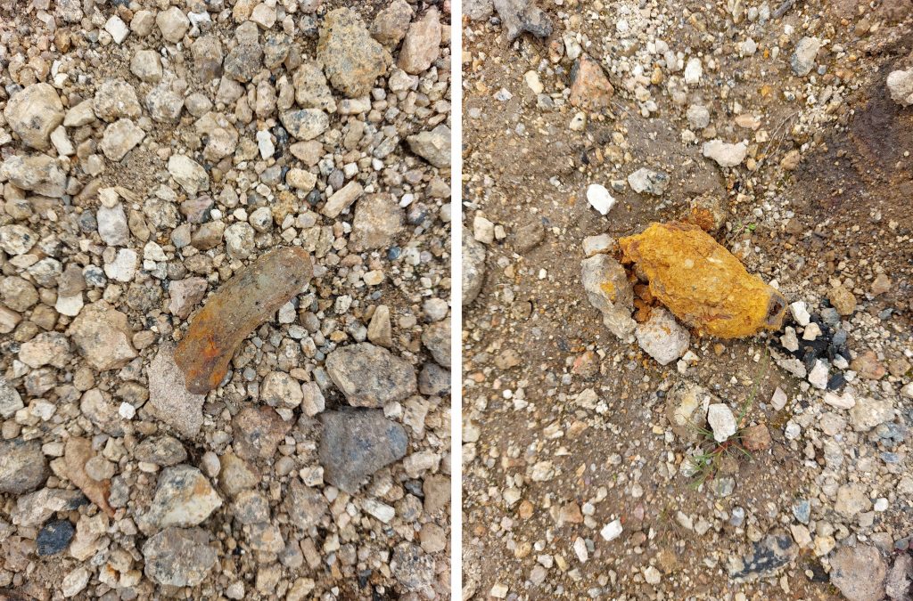
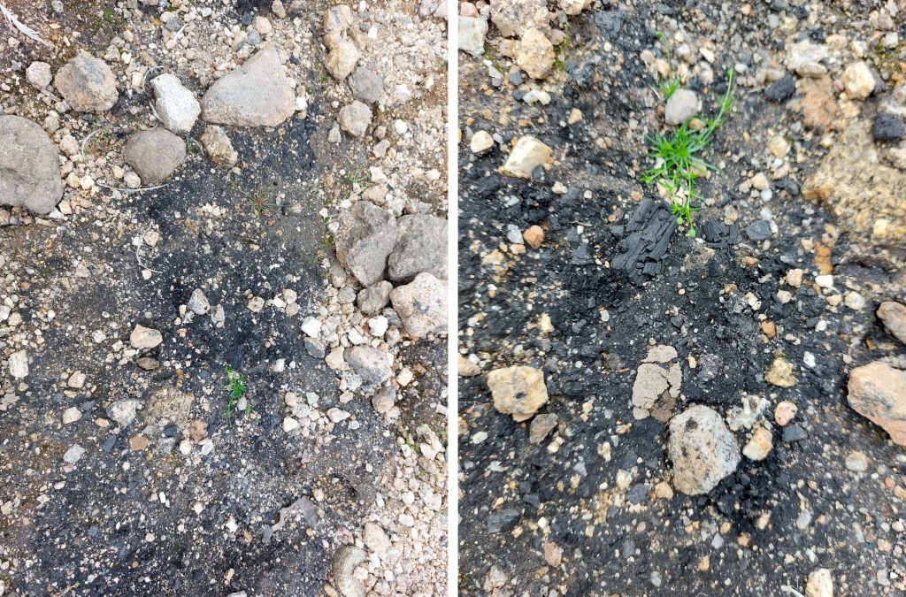
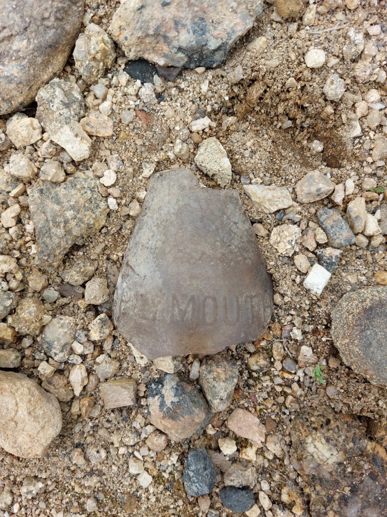
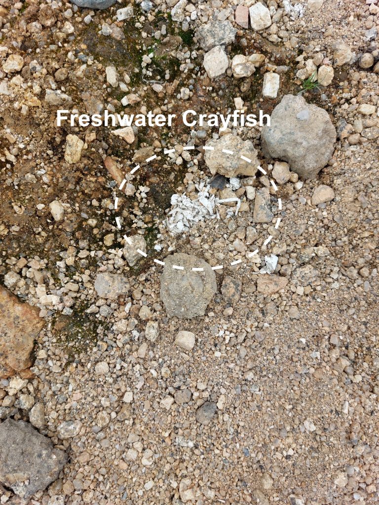
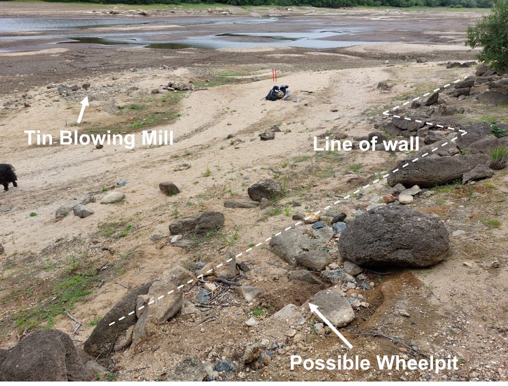
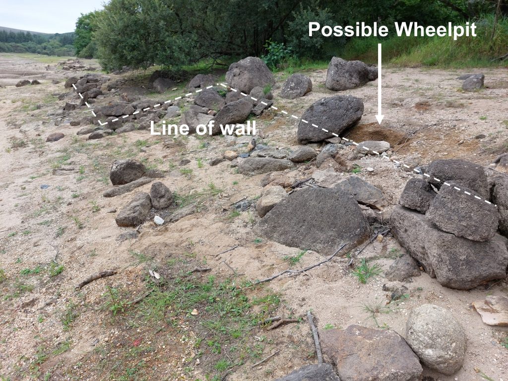
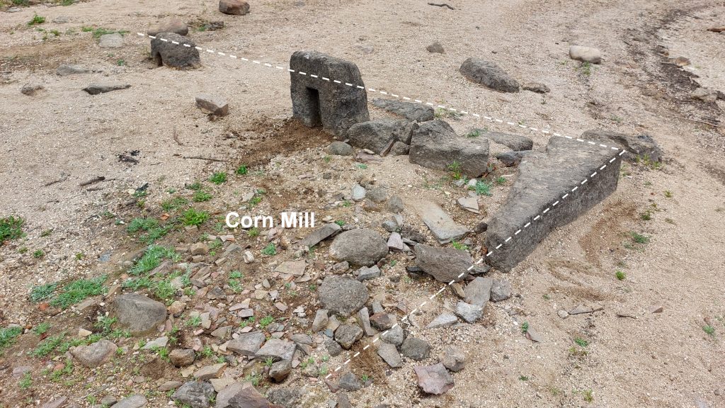
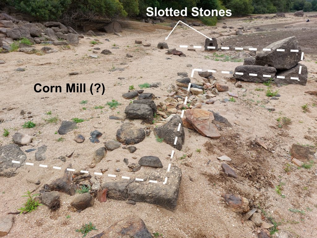
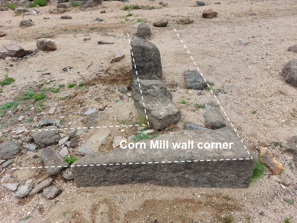
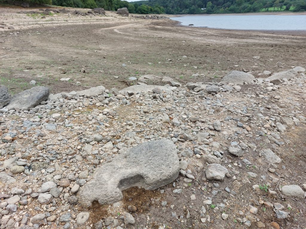
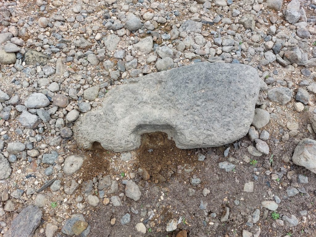
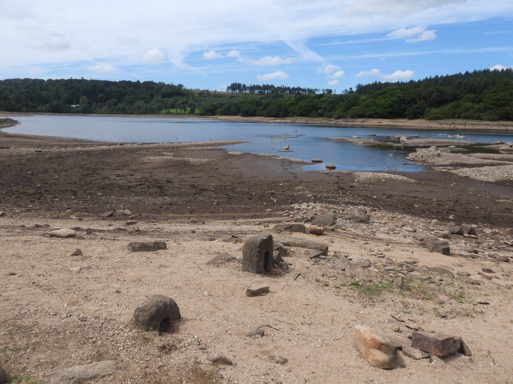
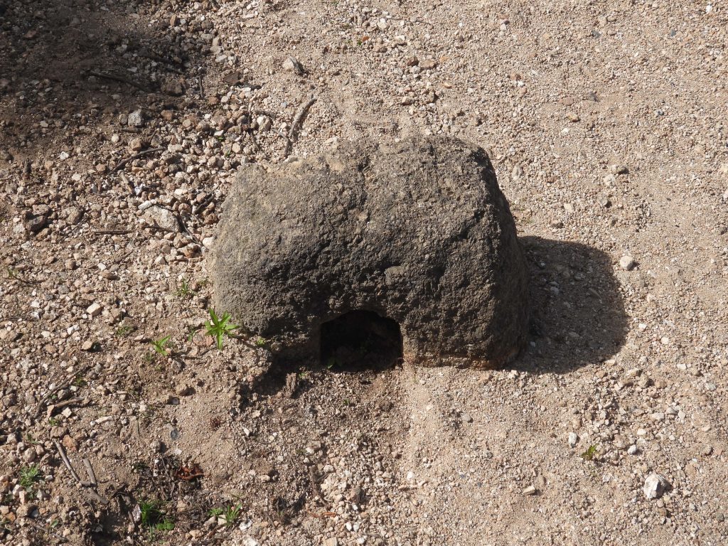
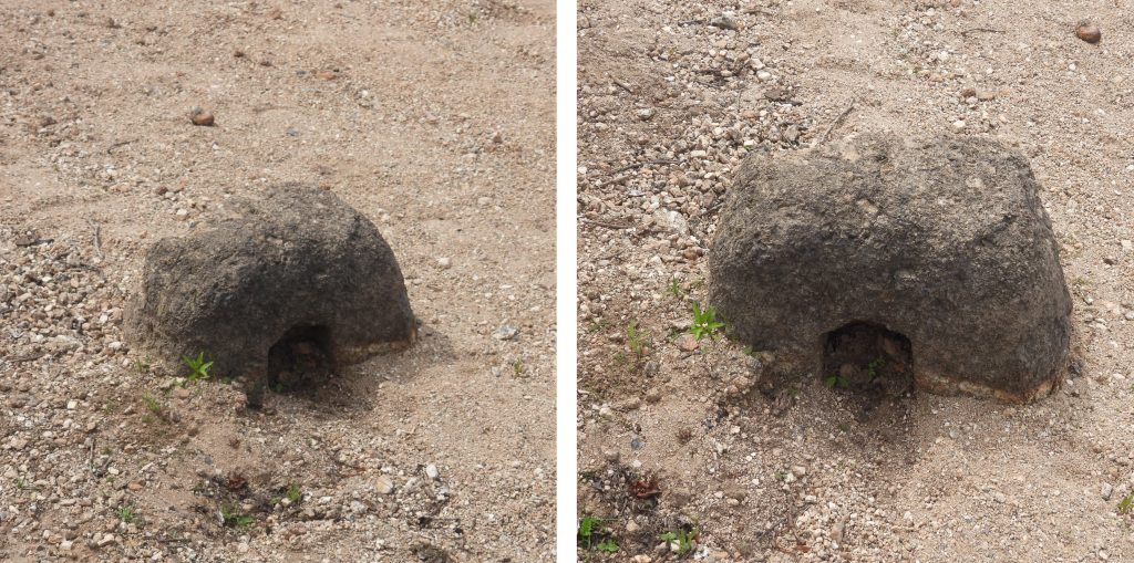
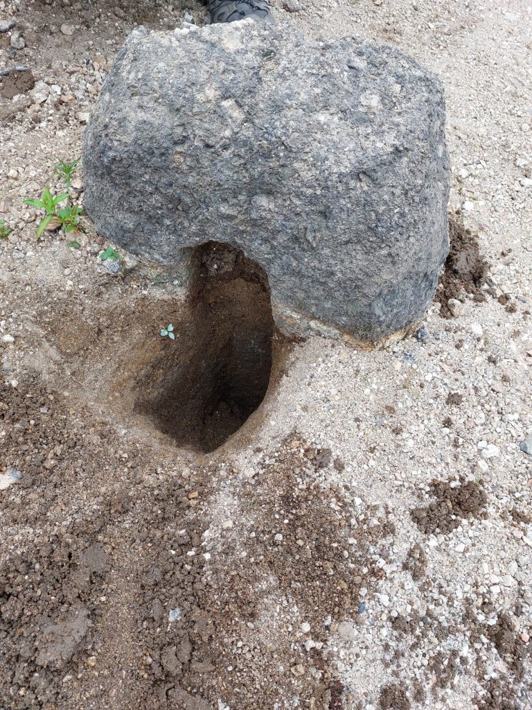
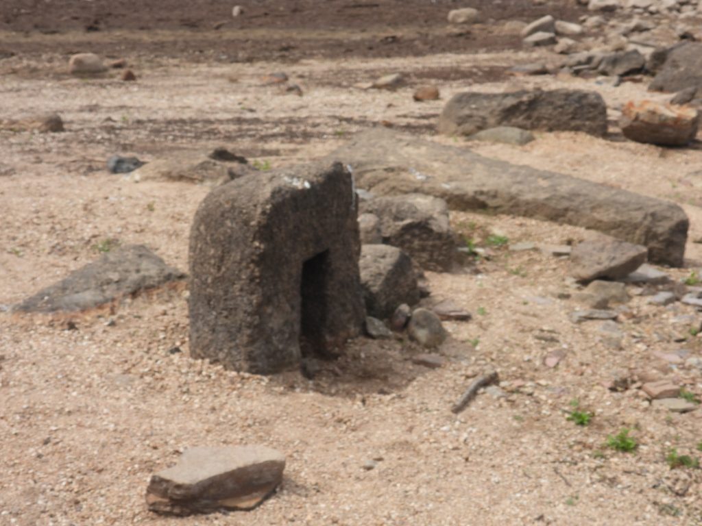
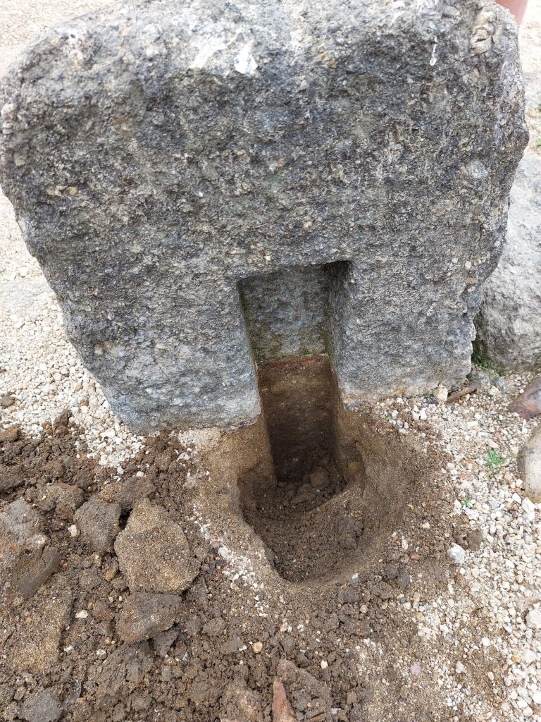
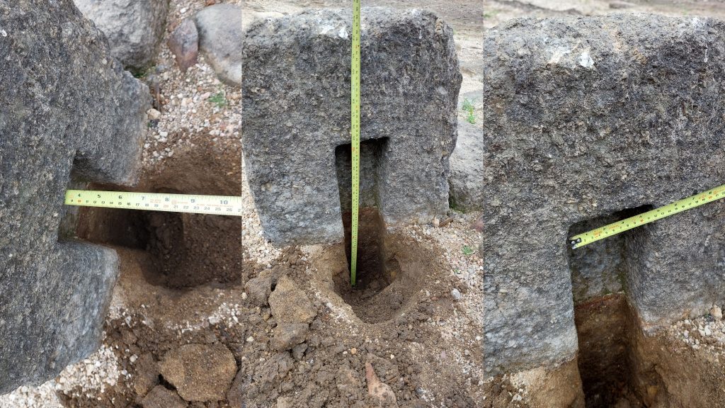
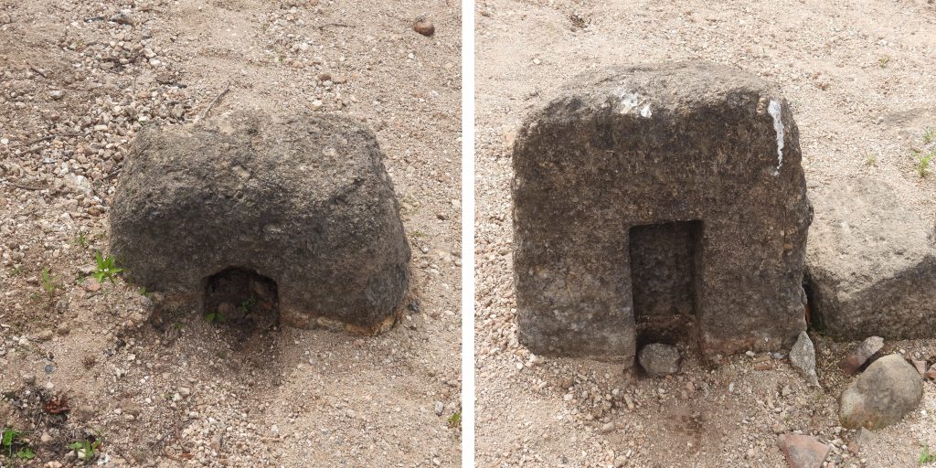
Tin Blowing Mill – In the Dartmoor HER it is recorded that: “A mould stone lying in the top water level of the reservoir was rescued by the foreman and transferred to the grounds of Plymouth corporation on the north shore”. R.H. Worth in 1940, speculated that the transferred mould stone came from this site. This site is considered in WORTH’s Dartmoor (Page 305) under “Longstone”The length of the tin blowing mill (east-west) was measured as being 6m. The mill was recorded at SX56065 68814The width of the tin blowing mill (north-south) was measured as being 3.95m. The walls are around 0.8m thick. Therefore the orientation (most likely) of the mill would have been east-west.Dr Tom Greeves records that tinners’ slag has been found at the Tin Blowing Mill (the spoil tip next to the mill would reveal more during the authors visit). There are several tin spoil tips quite close to the Tin Blowing Mill. The largest spoil tip is alongside the Mill at SX56067 68817Exploring the tin spoil revealed examples of black glassy matrix structures called slag, which was a waste product of the tinners’ reduced ore. Samples of slag can often be found lying on the ground surface near tin mills as with the Longstone Tin Blowing Mill. Within the slag ‘cassiterite’ shows up as small pale flecks within the black matrix. Source: DTRGWhen tin slag contains unrecovered ‘cassiterite’ it have been worth the while of the smelters to collect and crush it for re-smelting. Cassiterite is a tin oxide material (Sn O2). The name derives from the Greek kassiteros for “tin”, which comes from the Phoenician word Cassiterid referring to Ireland and Great Britain (Wikipedia)Also amongst the spoil were pieces of rusted metalCharcoal deposits within the spoil tip next to the Tin Blowing MillOld “Plymouth” glass bottle found amongst the spoil. Probably dates from the Victorian period.Within the waters of Burrator there is a large population of the invasive Signal Crayfish. Naturally spawned Brown Trout are believed to grow large on these. That said, this species are very invasive and eat a lot of invertebrates and if they spread into other waterways will cause an ecological problem.Reviewing the Dr Tom Greeves sketch, a possible wheelpit was noted. If this location is truly a wheelpit then it would seem unlikely it was related to the Tin Blowing Mill as it was over 10m away. It is speculated that if this were a wheelpit then could this have been a separate mill ? If, so could it have been a crushing mill, known as a knocking mill in the early 17th century and later being called a stamping mill. This possible structure is located at SX56069 68801Of consideration to the theory as to this possibly being a structure (knocking mill) is that the wall here makes two right angle bends. If the walls were built after the date of the wheelpit and possible knocking mill, why would they have been built with two right angles, unless they incorporated an extant structure ? The theory is purely speculative and the author would welcome any other theories or considerations. Of course the features here might be nothing more than from wall building.Moving 70-80m east, the site which is most likely mistaken as a tin blowing mill can be found. The Dr Greeves sketch labels this as a (possible) corn mill.The corn mill walls are easily traced as per the sketch. Of major interest are the two upright slotted stones which appear to be part of the west wall.The corn mill wall corner is defined by a substantial stone Another view of the corn mill. Of consideration is a report from the Royal Cornwall Gazette: Saturday 9th September 1809, viz: “….to be Leased, for a term of 99 years or for 3 Lives, to be named by the Purchaser, all the Messuage and Tenement, commonly called Longstone Mill, whereon a Mill formerly stood, together with 21 Acres of excellent Arable Meadow, and Pasture land. The Longstone Estate is exceedingly well calculated for a dairy or grazing Farm, there being 24 Acres of exceedingly rich Meadow Ground, with a plentiful supply of water in every field”. The emphasise within this report is on arable and certainly suggest the mill was no longer extant at that point. Axle bearing stone to the west of the corn mill. It is located on what appear to be a causeway and is approx 20-30m from the corn mill.The axle bearing stone can be found at SX55961 68753. It is speculated this most probably been a part of the original corn millThe site of the corn mill has many squared off blocks. The two slotted stones are by far an away the most conspicuous. Of interest is that Longstone Manor was built from 1633 and the Windstrew there around 1637 (we know that from inscriptions there – IE AE 1637 (John Elford & Anna Elford) , so was the possible corn mill built around the same period?At the corn mill there is a stone with a “scoop” taken out of it. Dartmoor Chris and the author speculate this could have been a lintel above a former water wheel, the “scoop” indicating the size of the wheel. Other theories would be welcomed by the author. More views of the corn millVarious squared off rocks at the millOne of the slotted stones. It appears to be built into the west wall of the mill. Could it be a possible tin mould stones or possibly a building block to hold machinery in the mill ?If this is a possible tin mould stone, the internal dimensions of the slot might provide more evidence. From the Dr Tom Greeves thesis (P229), he mentions 100 lb ingots were used in Devon…dating back to 14th C. To prove (or otherwise) if this was a tin mould stone, given the date of the mills in this area (early 17th century), the dimensions of the slot would be needed. Then using knowledge of tin density the weight of any possible ingot could be established.Slotted Stone 1. The size of the slot was taken in imperial units (as WORTH would have done). It was approx. 25″ x 4.5″ x 3.5″ = 393.75″ cu. If this was truly a mould stone then it would have held approx 106lb of Tin (estimate based using information from WORTH, where his calcs revealed approx 3.7 cu in was 1 lb of tin) . NOTE: The slot was backfilled as found and no damage was caused to the stoneThe second of the possible upright Mould StonesView of the larger of the two slotted stones looking south west towards the Longstone peninsula. it is very integral to the west wall of the corn mill.Slotted Stone 2. The size of the slot was taken in imperial units (as WORTH would have done). It was approx. 24″ x 4.5″ x 3.5″ = 378″ cu. If this was truly a mould stone then it would have held approx 102lb of Tin (estimate based using information from WORTHs Dartmoor – Page 305) . NOTE: The slot was backfilled as found and no damage was caused to the stone.Measuring Slotted Stone 2. Using WORTH’s estimate at 3.7 cu in per lb of Tin, this would have held 102lbs. Using the “modern” tin density of 7.265g/cm3 (or 0.2625lb / cu in) this would have held just over 99lbs. The sides of the slot do slope “outward” by appox. 0.5″ which could have facilitated ingot extraction.
Tin ingot calculations:
In “Worth’s Dartmoor” P305 under Longstone and Yeo Farm, he records two mould stones and the expected weights of tin they would have held.
Longstone: Mould Stone measuring 20” x 15.25” (top) and 17.5” x 13” (bottom) and 8” deep would hold 569lbs of tin. If I average the dimensions it’ll be 18.75” x 14.125” x 8” = 2118.75 cu in. Therefore, 2118.75 cu in / 569lbs = 3.72 cu in per lb of tin
Yeo Farm: Mould Stone measuring 12” & 10” (two ends) and 19” x 17” (two sides) and depth between 3” and 2.625” deep would hold 152lbs of tin. If I average the dimensions it’ll be 11” x 18” x 2.8125” = 556.875 cu in. Therefore, 556.875 cu. in. / 152 lb = 3.66 cu in per lb of tin
3.7cu in per lb of tin is therefore a good estimate. “Tin Density” is now known as 7.287 g/cm3 (or 0.2632 lb / cu in). So this equates to 3.8 cu in per lb (more or less the same as WORTH stated)
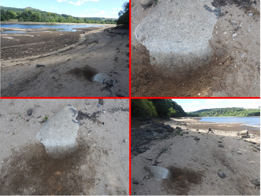
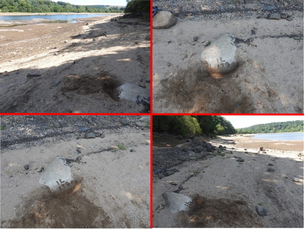
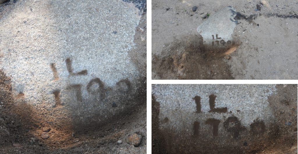
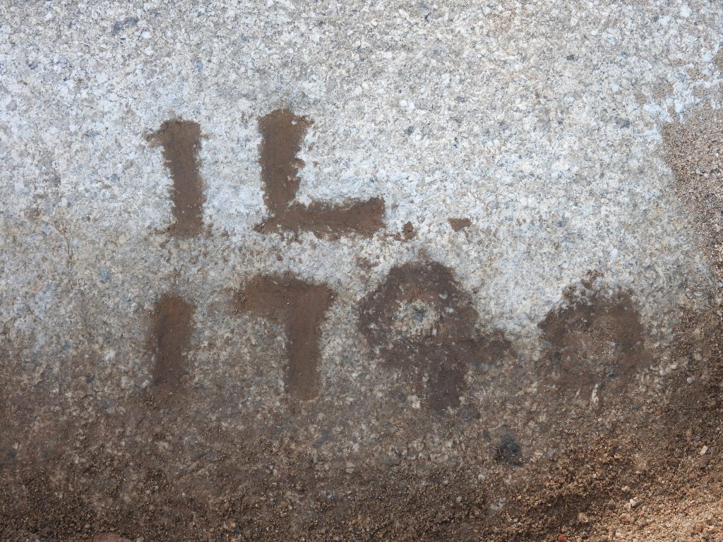
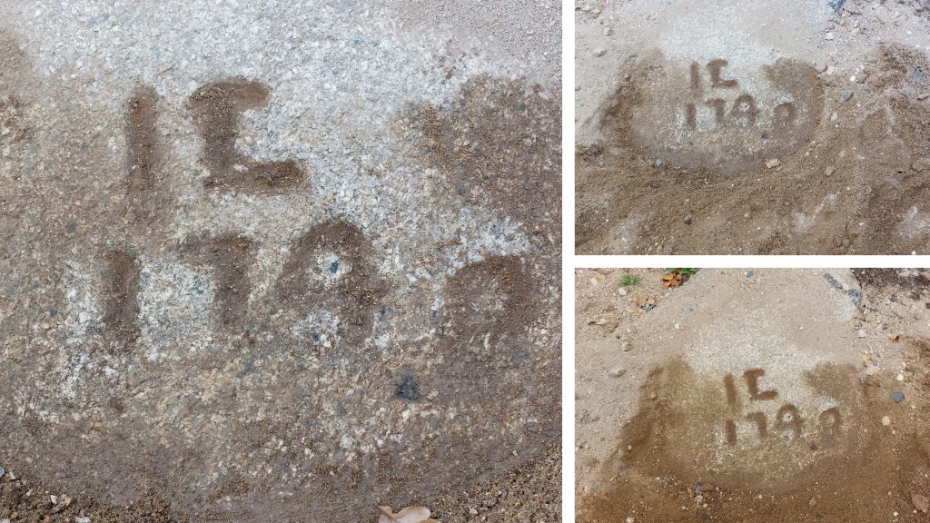
The two slotted stones (possible mould stones) appear that they could each have held approx 100lb of tin, which was consistent with tin ingots of that period. So what does this prove ? Is it possible that the builders of the corn mill used two mould stones from the tin blowing mill as part of the construction, especially as they appear to be a part of the outer wall? Is is possible that the corn mill stands on the site or a former tin blowing mill? Or is it just co-incidental that the two slots would have held approx. 100lbs of tin and in actual fact these stones were bearings to hold machinery? The author would welcome any other possible theories.More pictures of the unusual “scooped” out rock can be found amongst the remains of the corn millA short distance from the remains of the corn mill is an inscribed rock. The author would like to acknowledge and thank Mark Fenlon, for supplying to the author a photograph of the location of this rock with its inscription, which was needed as the inscription was buried under several 10’s of centimetres of reservoir grit / sand.Once the grit / sand alongside the rock had been cleared, an inscription was revealed, but wasn’t that discernible.The author used some damp earth to enhance the inscription, which revealed and “IL” above “1740”. The 1740 might have possibly read 1790. That said, Dr Tom Greeves, recorded inhis List of Known Devon Tin Mills c1450 – c1750 in 1981 that there is an “Inscribed stone on site is dated 1740”. There may not be a direct link of course between the tin blowing mill or corn mill and this inscribed rock. The author speculates that the “L” stands for Longstone. The author would be grateful if anyone knows what the “IL” stands for. It has been suggested (Alan Edgecombe) that the “L” is actually an “E” and therefore the “IE” refers to John Elford (note: and “I” was equivalent to a “J” in the 18th century). The Elfords lived at Longstone Manor until 1748, so the date fits.Close up of the inscription. Is the date “1740”Before leaving the site, the author buried the inscription and left the site as it had been found.The author revisited the inscription to see if the “L” might be an “E” (ie to consider the “IE” (John Elford) theory). It is possible the “L” is an “E” but the author must confess, in spite running fingers over the inscription, he is not convinced the “L” is and “E”. That said, this is just a personal observation.Possible tinners’ streamworks have been revealed by the low reservoir.
I have visited the site of the inscribed stone following your article and after a little work with eyes, charcoal and fingertips(very important) am sure that the inscription reads J E 1740.
The apparent letter ‘I’ was commonly used a ‘j’ i at that time and as you are no doubt aware John Elford livd at Longstone and died 1748.
Which fits very nicely.
I think your theory fits perfectly. I was thinking the first initial stood for John (an “I”) but followed the HER description with the second initial being a P as opposed to an E.
I am returning to the site this week to investigate the reports that there is tinners’ slag still around.
I will, no doubt be updating my webpage entry afterwards. I will, of course (with your permission) acknowledge you with J E 1740.
Hi Steve .
Go For it.
I have since my IE 1740 been taking an interest inthe location of Headweir Cottage and the take-in of Drakes leat.
The causeway you mentioned in your 1740 seems to lead directly to the river where there is a substantial pile of rubble on each side with what appears to be a ford (or two) between them. Amongst the rubble on the north side of the river, a worked granite stone is visible and after some research and a few calculations side I am of the opinion that the two piles of rubble might be the remains of Headweir Cottage.
I shall be revisiting the site in the near future before the tide comes in and try to find some more evidence.
Ps The position of of Cullimore cottage and Headweir was one of my points of interest.
Hello Steve,
As per my previous I have photos of the intake of the plymouth leat which I would like to offer for your comments.
Unfortunately in th elack of your emaol address I have not ben able to forward them to you.. Please could you supply an email.
Hello Author
I to have seen the blowing house remains when the “tide was out”.
The scooped out stone I wondered if it could be the part base of the furnace bowl?However alone it would not be enough to form a bowl.Outside of the foundations is a large piece of stone that looks heat stressed-the bowl base?. I photographed the date stone after it had been highlighted with charcoal and it seemed to be JE 1740.
I believe the Elfords are in my ancestral line.
Alan

Alan August 17, 2022
Hello Author,
I have visited the site of the inscribed stone following your article and after a little work with eyes, charcoal and fingertips(very important) am sure that the inscription reads J E 1740.
The apparent letter ‘I’ was commonly used a ‘j’ i at that time and as you are no doubt aware John Elford livd at Longstone and died 1748.
Which fits very nicely.
Regards
Alan F Edgecombe
alan.edgecombe@outlook.com
SteveGrigg1961 August 17, 2022 — Post author
Hi Alan,
I think your theory fits perfectly. I was thinking the first initial stood for John (an “I”) but followed the HER description with the second initial being a P as opposed to an E.
I am returning to the site this week to investigate the reports that there is tinners’ slag still around.
I will, no doubt be updating my webpage entry afterwards. I will, of course (with your permission) acknowledge you with J E 1740.
Thank you once again, much appreciated,
Kind Regards,
Dartmoor Explorations (Steve)
Alan August 26, 2022
Hi Steve .
Go For it.
I have since my IE 1740 been taking an interest inthe location of Headweir Cottage and the take-in of Drakes leat.
The causeway you mentioned in your 1740 seems to lead directly to the river where there is a substantial pile of rubble on each side with what appears to be a ford (or two) between them. Amongst the rubble on the north side of the river, a worked granite stone is visible and after some research and a few calculations side I am of the opinion that the two piles of rubble might be the remains of Headweir Cottage.
I shall be revisiting the site in the near future before the tide comes in and try to find some more evidence.
Ps The position of of Cullimore cottage and Headweir was one of my points of interest.
Regards. Alan Edgecombe
SteveGrigg1961 September 3, 2022 — Post author
Hi Alan,
Thank you for your comments. I hope you manage to visit the site before the tide comes in.
Regards,
Steve
Alan September 3, 2022
Hello Steve,
As per my previous I have photos of the intake of the plymouth leat which I would like to offer for your comments.
Unfortunately in th elack of your emaol address I have not ben able to forward them to you.. Please could you supply an email.
Regards
Alan
SteveGrigg1961 September 3, 2022 — Post author
Hi Alan,
Thank you for your comment. I would be delighted to receive photographs of the intake of Plymouth Leat.
You can email me at sgrigg904@gmail.com
Kind Regards,
Steve
Alan Peters May 6, 2023
Hello Author
I to have seen the blowing house remains when the “tide was out”.
The scooped out stone I wondered if it could be the part base of the furnace bowl?However alone it would not be enough to form a bowl.Outside of the foundations is a large piece of stone that looks heat stressed-the bowl base?. I photographed the date stone after it had been highlighted with charcoal and it seemed to be JE 1740.
I believe the Elfords are in my ancestral line.
Alan
SteveGriggDartmoor May 7, 2023 — Post author
Hi Alan,
Thank you for your comments.
Kind Regards,
Dartmoor Explorations