A collection of walks, discoveries, insights and pictures of exploring Dartmoor National Park
July 25, 2024
Roundypark Farm
The ruins of Roundypark farm lie to the south west of Crazywell Pool, close to Cockle’s Gate and the track which was once part of the monastic way between Buckfast and Tavistock. It is situated within a large sub circular enclosure and it is thought the name derives from the ’round’ shape of the Bronze Age hut circles and enclosures, which lie nearby to the west.
The farm is partly datable by virtue of there once being a lintel inscribed ‘RC 1668’, which was photographed at the farm in October 1894 by the Victorian writer, photographer and founder of the Dartmoor Preservation Association, Robert Burnard. That said, the farm may date from an earlier period as there is a published reference to this site dating it to 1609, when a “presentment respecting the forest, referring to this part of the moor, speaks of ‘certayne howses’ that had been erected here and of land that had been enclosed”.
The date at which this site was abandoned is not known with great certainty, however, the Tithe Map of 1839/40 shows the buildings still to be roofed (and tenants recorded). The Burnard picture of 1894 shows the farmhouse being ruinous, without a roof. By the early 20th century, when William Crossing visited the area, the site was totally deserted.
Throughout the known period of occupancy, the farm has been known as Roundaparke, Round Park, Roundpark, Roundapark, Roundepark and Roundypark. The layout of the farm has many typical and interesting features of older Devon farmhouses, which are recorded in this post.
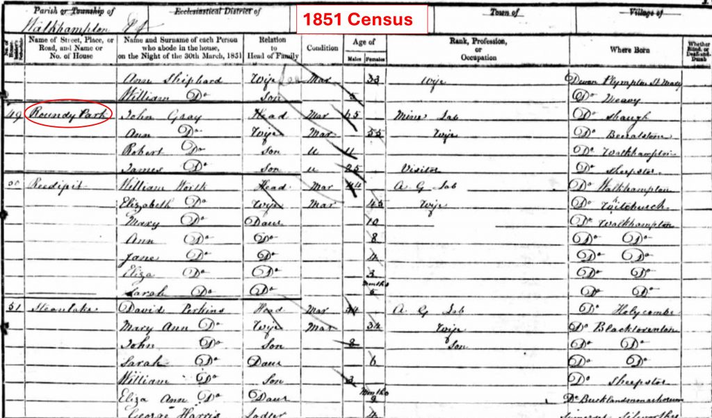
Sketch map of Roundypark, with interpreted features. The farmstead entrance appears to have been via a lane (Holloway) which can be found leading from the farm to the open moor to the east. The gateway to the open moor, lies around 40m to the north of Cockle’s Gate on the old Buckfast – Tavistock monastic routeThis table shows the tenants dating from circa 1673 through to 1840. In 1783, the farm was known to have been owned by James Modyford. The landlord for Abraham Giles (Jr) would have been Sir Ralph Lopes (Maristow Estate). Of interest are some of the recorded rents, which were 7s a year around 1801, for the farmstead with £1, 8s a year for the land. No pre-1673 Walkhampton registers survive, but it is assumed the RC dated lintel refers to Ralph Cockle (as he was tenant in 1673) and not as William Crossing suggests as Richard CrymesEntry from 1851 census with Gray family living at the farmOf interest is the 19th century tithe map which shows the building was still roofed and was located within a curvilinear enclosure. This sketch is a representation of the map with apportionment names (in red) for ‘Roundepark’. Apportionment Number 985 was ‘House and Court’ with Field Number 986 as ‘Gardens’. Of interest is that even circa 1840, the name ‘Cockle’ (Cockles Plat) was being used, which was probably a nod to the Cockle tenants from the 17th century ! No doubt, Cockle’s Gate has similar originsThis view is the south boundary of the farm as seen from the main track(s) coming from Norsworthy Bridge / Leather Tor Bridge area. The modern forest belies the field system which lie beyond. The picture was taken at around the point shown as ‘Stile Meadow’ on the Tithe MapLooking from the track around the area of ‘Great Meadow’. The author suggests avoiding the temptation to enter here if visiting the farmstead (as there would be fences and walls to traverse) and to continue to Cockle’s GateGatepost at Cockle’s Gate – location SX57848 70076. From this point, if visiting Roundypark, the wall to the north should be followed for approx 40mCockle’s Gate looking west towards Burrator Reservoir. Cockle’s Gate looking towards Sheepstor and Burrator Reservoir. Gateway to Roundypark with indications that it was at one time blocked in. The Gateway can be found at SX57850 70107The lane (Holloway) leading from the gateway to the farmstead. The Holloway is 2.6 metres wide and 1 metre deep. It has a drystone revetment on its north side and to the south there is a drystone wall.The west end of the Holloway enters into Roundypark Farmyard. Looking in a north easterly direction the obvious ruins of the original Farmhouse and Shippon / Barn can be seen.This Robert Burnard photograph from 1894 (reproduced in Hemery, High Dartmoor, 1983, page 85, Plate 86) shows larger stonework in the upper storey of the Farmhouse and a dated lintel with ‘RC 1668’ on it. The ‘RC’ almost certainly denotes Ralph Cockle who was tenant in 1673.Combined 1894 and July 2024 photographsThe ‘RC 1668’ Lintel is now located at Wembley Walk at the Burrator Discovery Centre and would have been moved here in the 1920s. The ‘Wembley Walk’ folly, also known as Burrator Arches comprises two “arches” (with various artefacts), which were built between 1928 and 1934 in a section of lane which was once part of the access road to Sheepstor and Longstone Manor. The folly takes its name from the Empire exhibition at Wembley, London which was visited as a celebratory trip to the capital by many workmen and their wives who were involved in the enhanced constructions of the dams at Burrator between 1923 and 1928.Close up of the ‘RC 1668’ inscription. Interestingly, Hemery (High Dartmoor, page 142) concurs with Mr L. Govier (Walkhampton) at the suggestion that the inscription commemorates the baptism of Ralph Cockle in that year (i.e Ralph Cockle Junior as Ralph Cockle Senior was tenant in 1673!). This is rather an unusual suggestion as inscribed lintels across Dartmoor (without precedence to the knowledge of the author) were usually to commemorate an original build or re-build of a property where the tenant or owner would inscribe the date and their initials.The Farmhouse is terraced into the hillslope with had a west-facing door leading onto a passage leading to the farmyard. It has been suggested that this building was originally a Medieval LonghouseA Shippon / Barn adjoins the lower (south) side of the Farmhouse. It is a single-roomed building with a 1.3 metre high drystone wall. At the lower end of the Shippon / Barn is what is believed to have once been a ‘lean-to’The Farmhouse is believed to have been a 2-roomed building. The ruins comprise a 0.7 metre wide drystone wall standing up to 2.6 metres high.The lower room of the Farmhouse has been recorded as being 3.9 metres by 3.3 metresThe lower room of the Farmhouse with the entrance on the right (west) side of the pictureEvidence of a window between the lower Farmhouse room and the Shippon / BarnOn the east side of the lower room of the Farmhouse there is a ‘sunken pit’ which has been interpreted as the base of a stairwellThe upper room measures 5.1 metres by 3.9 metres and is separated by a rubble wall from the lower room. The possible staircase is located at SX57805 70128, which is 0.7 metre deep and drystone-lined. It has internal dimensions of 2.4 metres by 1.4 metres.Looking across the Farmhouse from its north east corner towards the FarmyardThe entrance to the FarmhouseInside the Shippon / Barn at SX57805 70123The interior of the Shippon / Barn measures 7.6 metres by 3 metres and has a west-facing the doorway leading onto the FarmyardShippon / Barn from the south east corner. The block ‘tumble’ in the foreground is believed to be where there was a ‘Lean-to’The Shippon / Barn interiorWall between the Shippon and the FarmhouseTo the north of the Farmyard is a raised flat area, which is believed to have been a GardenContextual view of the Farmyard and the Garden, with the Garden raised about 1 metre higher than Farmyard There is some block tumble between the Garden and the Farmyard, possibly suggesting a dividing wall at one point, albeit no foundations appear evidentThe Garden was clear of rocks and no doubt was used to grow cropsOn the west side of the Farmyard is a second Gateway at the farm. It is located at SX57797 70109To the right (north) of the Gateway are the remains of a substantial (Farmyard) wall. Intriguingly there are (at least) two niches here, the purpose of which are unknown to the author. Location is SX57794 70119Behind the left (south) Gatepost there are the remains which has been interpreted as being either an Outside Lavatory or a Dog KennelThe presumed Outside Lavatory or Dog Kennel is a small, open-sided structure, measuring 2.1 metres by 1.4 metres internally and has a 1 metre high drystone wall.To the west of the presumed Outside Lavatory or Dog Kennel is a 2-roomed Outbuilding with walls 1 metre wide and 1.1 metres highThe eastern room of the Outbuilding measures 7.3 metres by 2.4 metresThe western room of the Outbuilding measures 5.8 metres by 2.4 metresThe western room of the OutbuildingThe eastern room of the OutbuildingThe eastern room of the Outbuilding is located at SX57780 70114. This Outbuilding may have provided additional storage space or an undercover work areaA presumed Garden / Enclosure are lies within an abandoned stone hut circle, 35 metres to the north-west of the Farmstead. The interior has been measured as being 9.6m by 6m and the 1.1m wide surrounding wall stands up to 1.2m high. Sandy Gerrard records this structure as being probably a Field Barn in a reused hut circle.The outlying Garden / Enclosure (or Field Barn) is located at SX57770 70143Back to the farm. At the south end of the Shippon / Barn, there is evidence of a ‘Lean-to’ with a door jambThe door jamb is located at SX57811 70113Mike Brown in Walkhampton’s Abandoned Farms – Volume 7, suggests this area is actually three small Outhouses. Colin Wakeham in his paper ‘Maristow Estate Farmhouses 1800-1913: A Chronological Development’ suggests this is a Lean-to or a small PenTo the east of the Shippon / Barn and adjacent to the Holloway is a stone-lined hollow, measuring 8.8 metres by 2.2 metres and up to 1.5 metres deep. It has been interpreted as a Root Crop Storage Facility.The Root Crop Storage Facility is located at SX57822 70114The Root Crop Storage Facility with the Farmhouse and Shippon / Barn beyondTo the west of the Root Crop Storage Facility is another flat area believed to have been another Garden areaThe overgrown Garden area to the east of the Farmhouse and Shippon / BarnThe overgrown Garden area at SX57815 70118 has been recorded as measuring 11.3 metres by 8.54 metres