A collection of walks, discoveries, insights and pictures of exploring Dartmoor National Park
July 25, 2021
Dartmoor Explorations Calendar – September
In 1991, the Dartmoor National Park Authority (DNPA) published a spiral bound diary to commemorate their fortieth anniversary (1951-1991), called “The Dartmoor Diary”.
Inspired by this publication (and some of the entries in it) and to celebrate the DNPA 70th anniversary year in 2021, the “Dartmoor Explorations Calendar” records an event or story, complemented with photographs for each day of the year.
This page of the Dartmoor Explorations Calendar celebrates September on Dartmoor and its immediate borderlands.
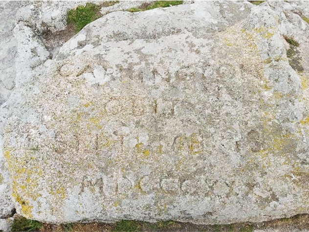
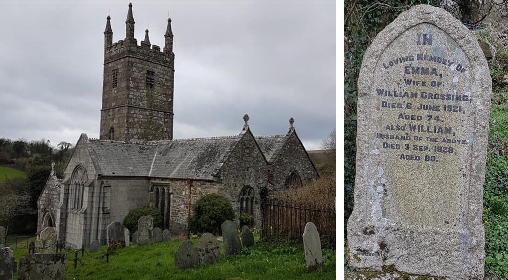
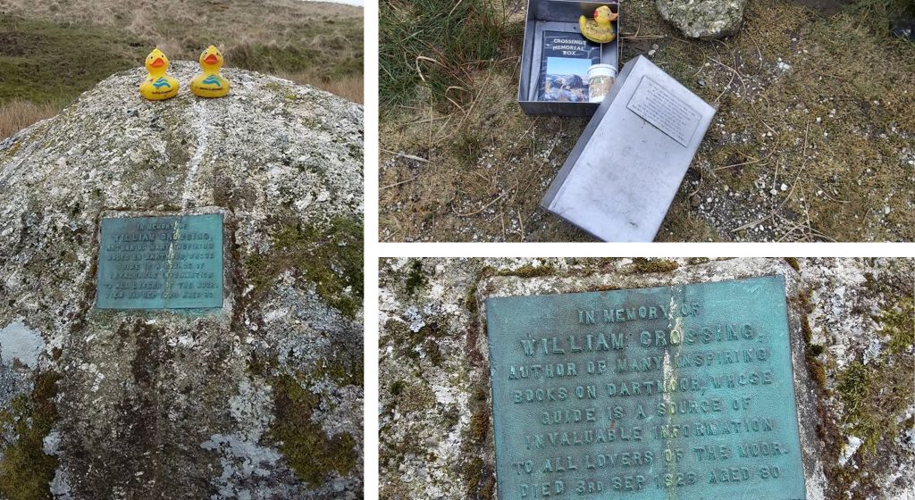
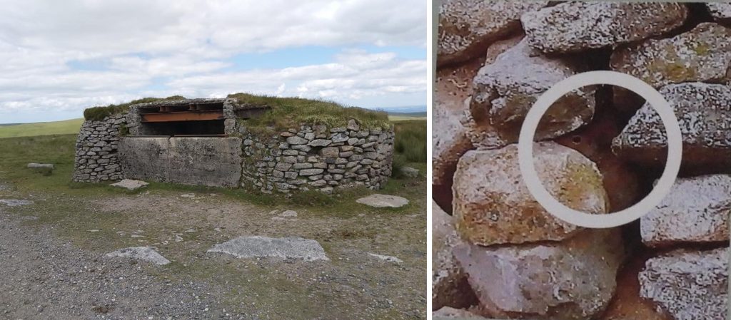
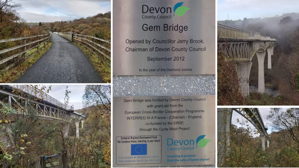
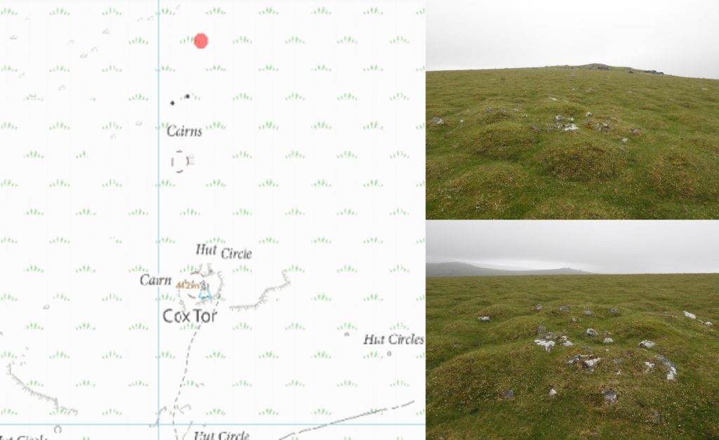
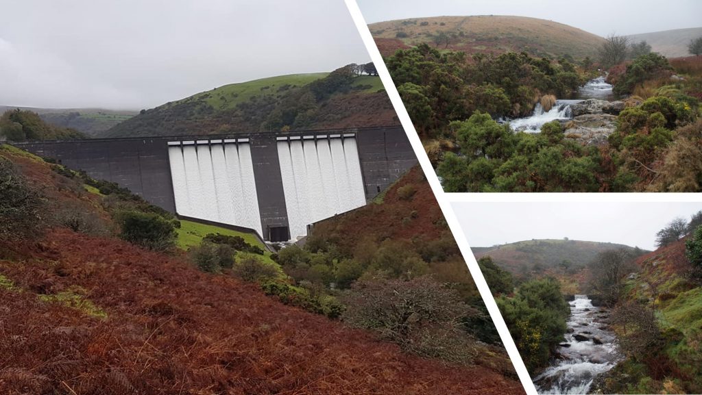
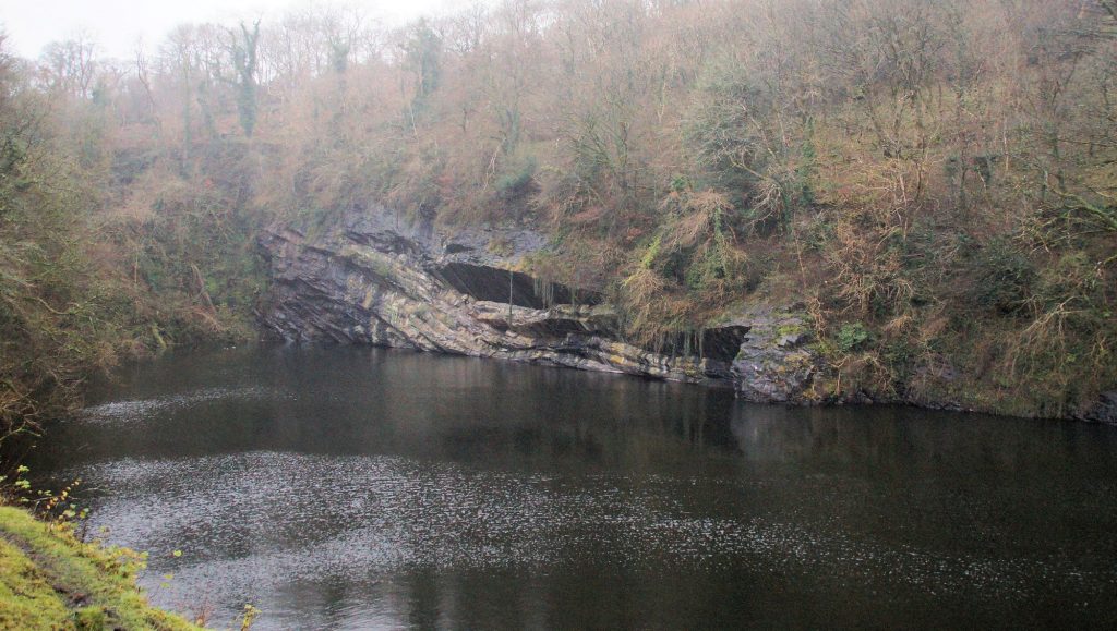
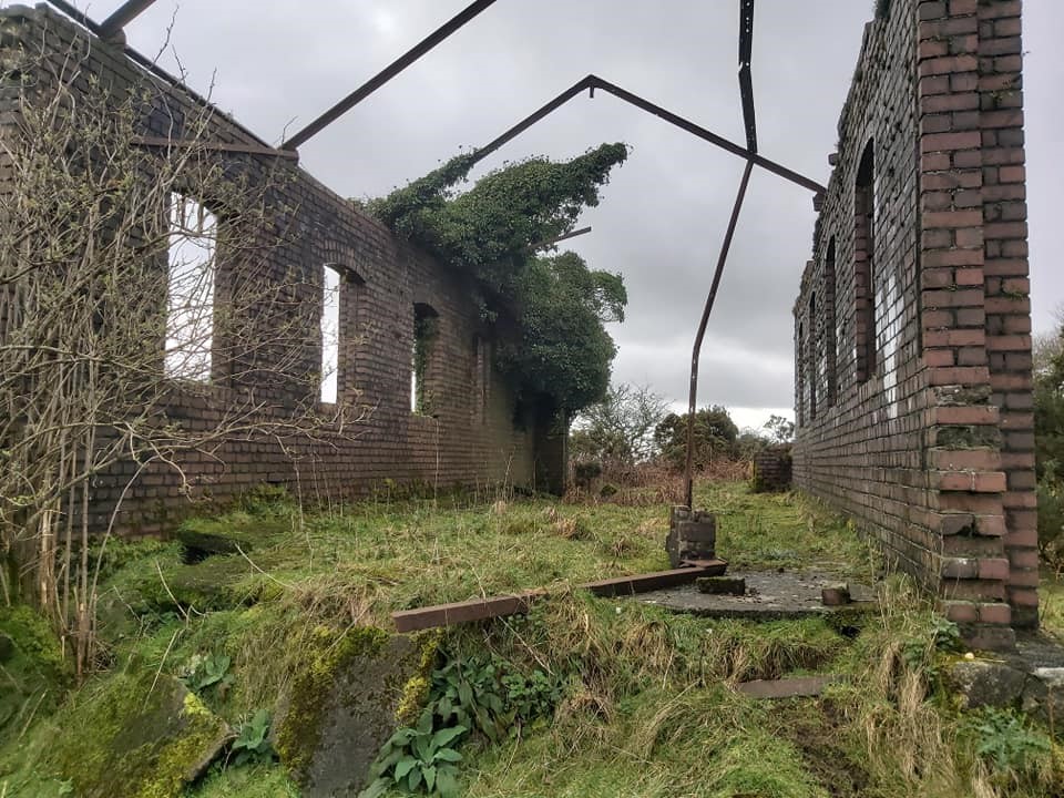
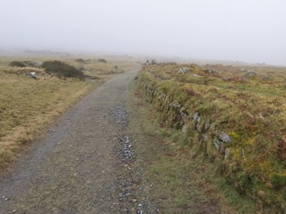
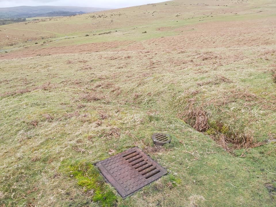
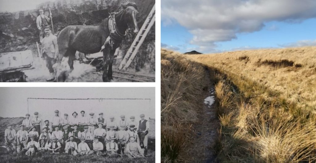
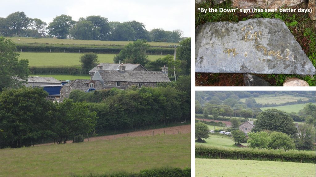
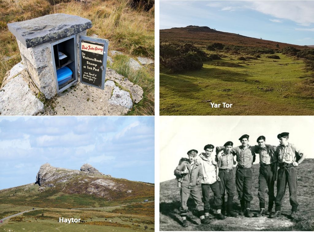
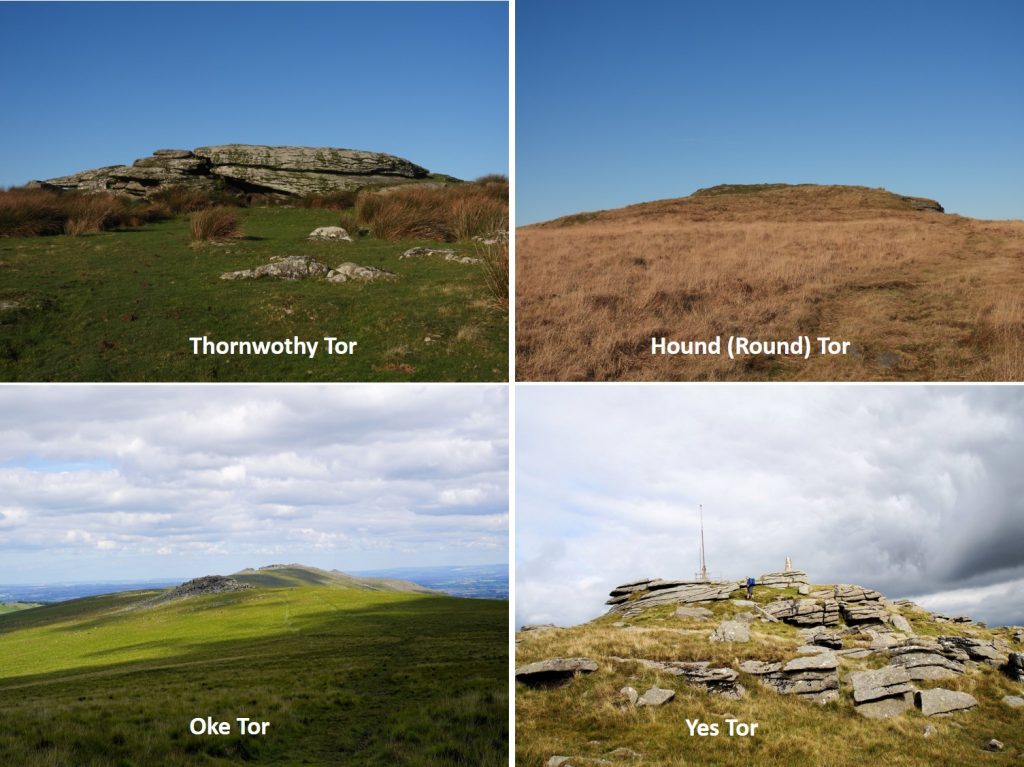
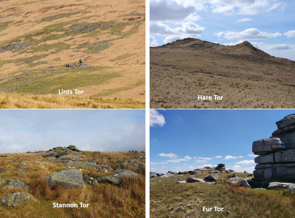
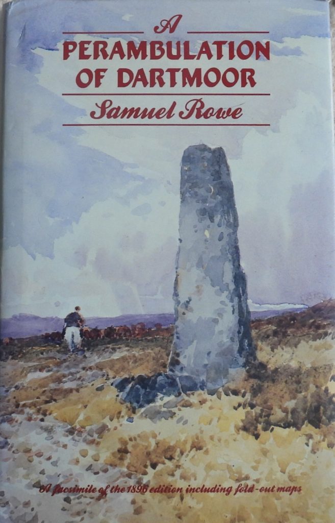
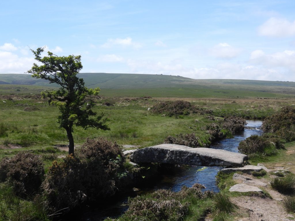
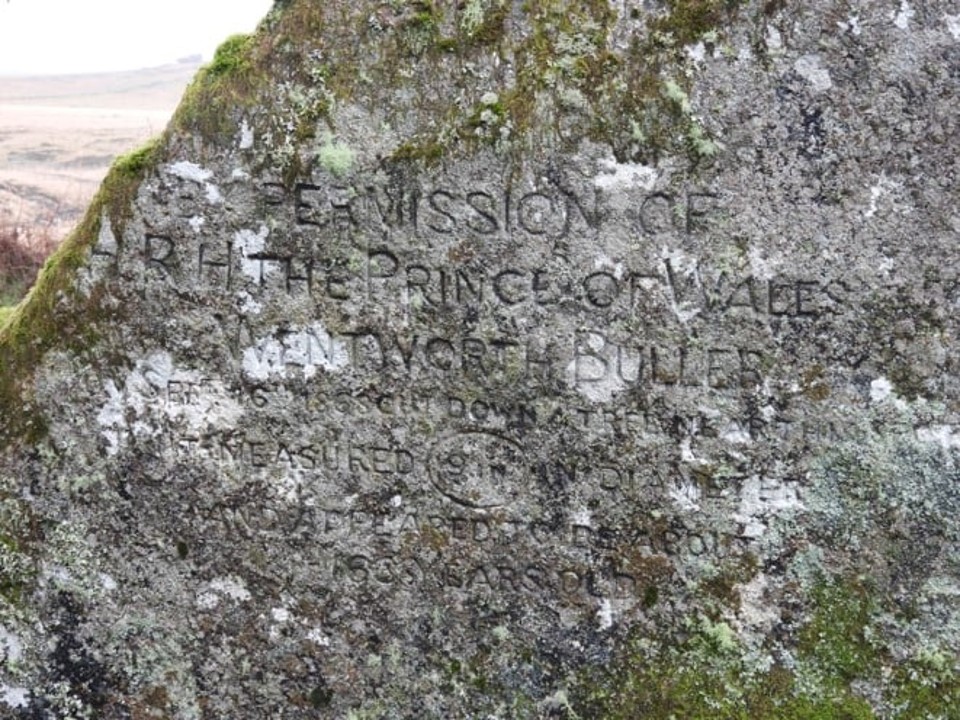
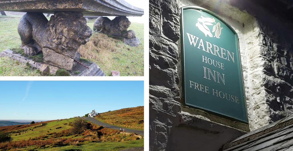
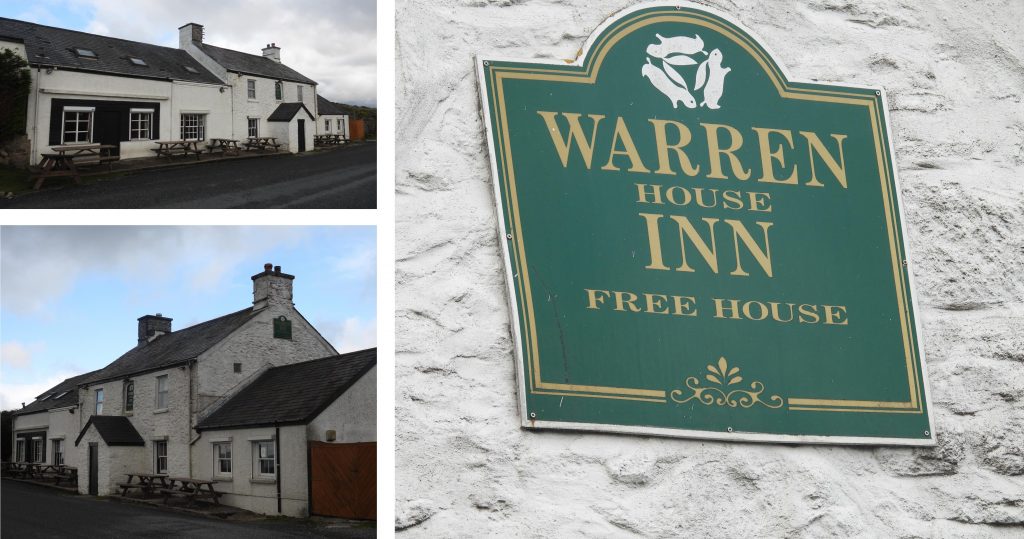
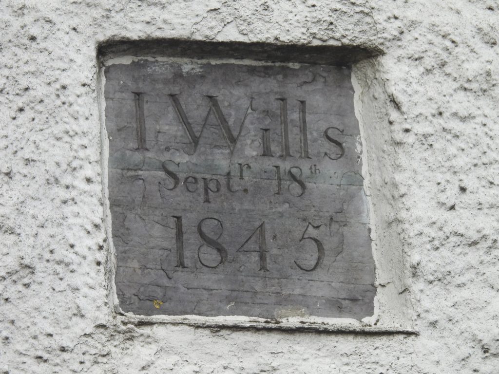
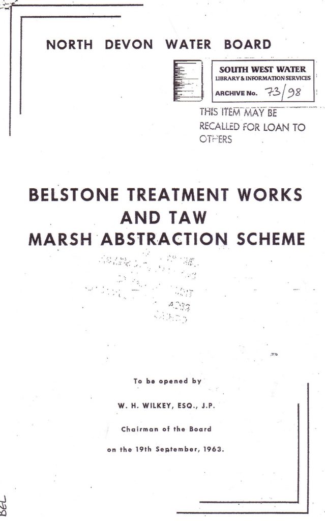
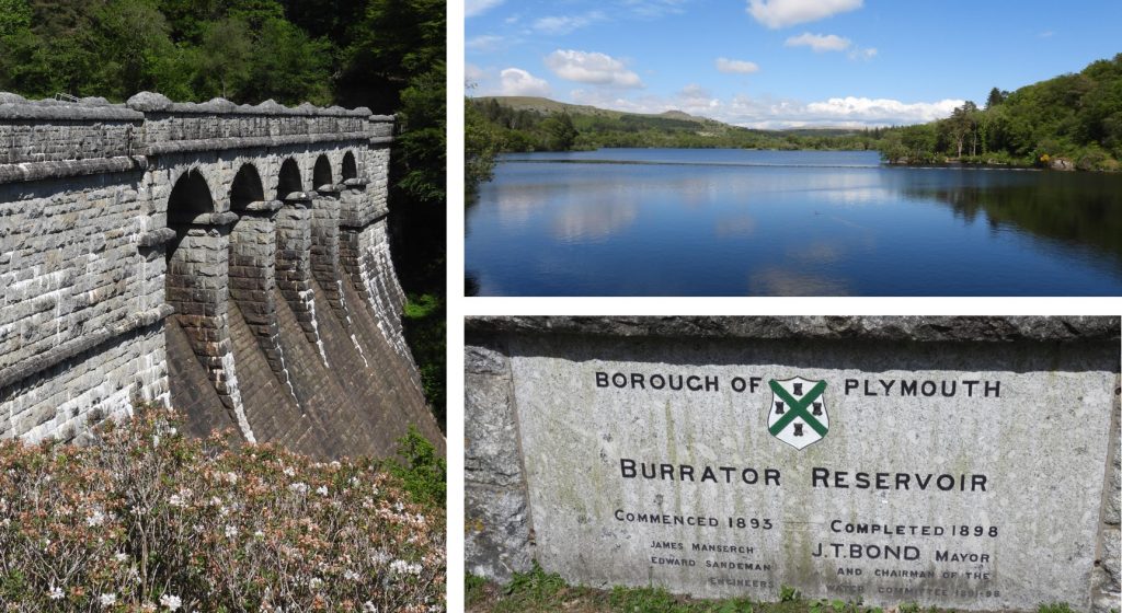
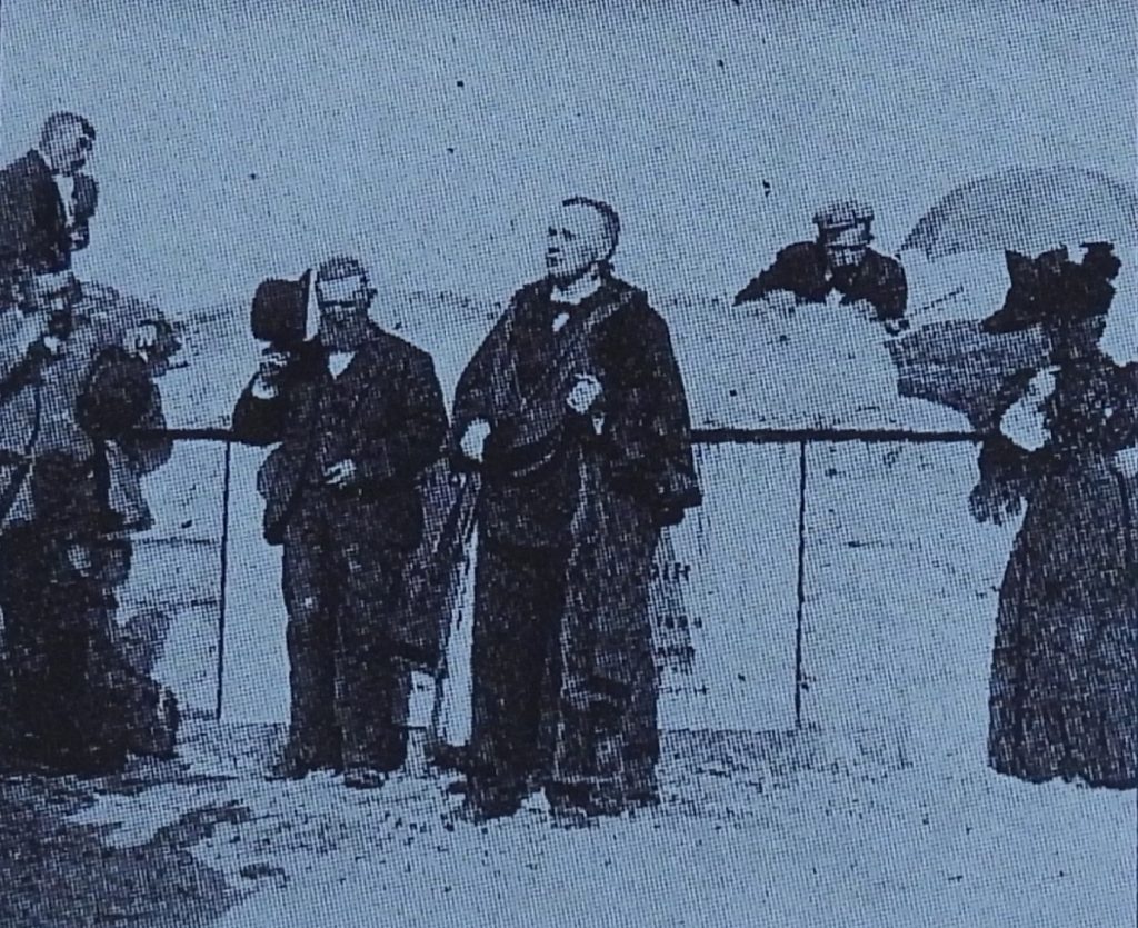
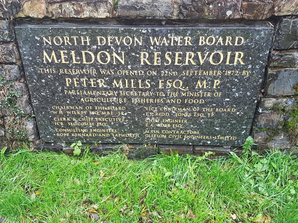
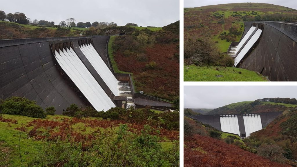
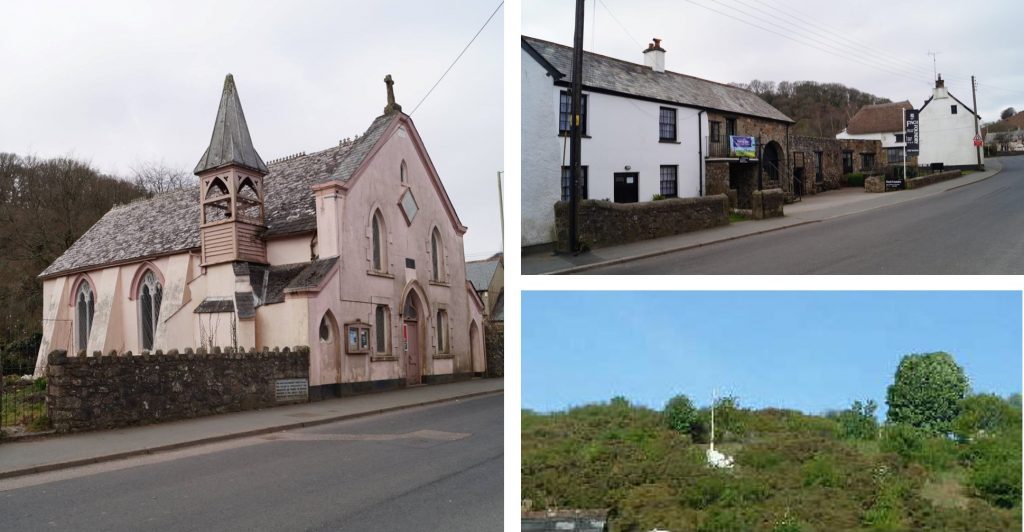
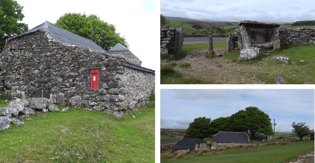
1st September 1893: Chagford was first lit by electricity. Chagford (hydro-electric) Power Station was originally built in 1891 by G.H. Reed, a local millwright and machinist, to power his factory, which is located near Chagford Bridge. It was refurbished in 1911 and again in 1950. The leat take off from the Teign is located near Holystreet Manor.1st September 1893: Chagford was first lit by electricity. The tiny power station became the smallest plant to ever supply the national grid. It was decommissioned in the 1980s.2nd September 1830: Dartmoor poet Noel Thomas Carrington died on this date. He was 53 years old and is buried at Combe Hay near Bath. The Dewerstone and the woods below were once regular visiting places inspiration for Carrington as noted by William Crossing in his ‘Gems in an Granite Setting’. It is recorded (Legendary Dartmoor website) that after his death, it was proposed to erect a monument to him on the top of the Dewerstone. Furthermore, George Wightwick, an architect produced a design, but for some reason the project was never completed.2nd September 1830: Dartmoor poet Noel Thomas Carrington died on this date. On top of the Dewerstone as stated by William Crossing there is a rock that has the following inscription carved on it: “Carrington – Obit Septembris MDCCCXXX“. More information about Carrington, including his poem ‘Dartmoor’ can be found here: https://www.legendarydartmoor.co.uk/carr_dart.htm2nd September 1740: William Nicholls is issued a new lease on Dittisworthy or Ditserry Warren. A condition of the tenancy is that he will “build up the dwelling houses, outhouses and hedges”. William Nicholls also covenants to provide one days labour for the manor at harvest time (or pay 4d as a fine in lieu) – reference Mike Brown in a Dartmoor diary of yesteryear. William Nicholls also held Legis Tor Warren. The warren was then handed onto his son John Nicholls in 1780. There was a break between 1782 and 1800 of the Nicholls family as tenants, but they continued between 1800 until 1830, when the land passed to Nicholas Ware who leased the holding. Warrening came to an end in 1947 when the Ware family finally closed down the warren in upon the death of Percy Ware.2nd September 1740: William Nicholls is issued a new lease on Dittisworthy or Ditserry Warren. Of significance is that the Maristow Estate estate funded work at Ditsworthy in 1824-25 with a rebuild, extension and stabling added2nd September 1740: William Nicholls is issued a new lease on Dittisworthy or Ditserry Warren. Top floor inside the warren house – June 20242nd September 1740: William Nicholls is issued a new lease on Dittisworthy or Ditserry Warren. Ground floor – June 20242nd September 1740: William Nicholls is issued a new lease on Dittisworthy or Ditserry Warren. Ditsworthy Warren was approx 220 acres (according to the Tithe Map 1844). Its boundary is defined as “on the south by the Plym; on the west by a long wall from the Legis Tor Warren boundary to Sheepstor Brook at Burrcombe Gate. The eastern boundary down to the Plym is problematical but is believed Sheepstor Brook upstream for a little distance then east to the ridge of Eastern Tor then following a line of unmarked boundary stones to Drizzlecombe Brook and the Plym”. In its heyday Ditsworthy was the largest warren in Britain.2nd September 1740: William Nicholls is issued a new lease on Dittisworthy or Ditserry Warren. Rebuilding the drystone wall at the southern boundary of Kennel Court. The author spent a couple of days in a group in June 2024 on this. 3rd September 1928: William Crossing, probably one of the most famous writers and chronicler of Dartmoor and the lives of its inhabitants passed away on this date. His grave (along with his wife Emma) can be found in St. Peter Church, Mary Tavy. In 1872 he married Emma and settled down at South Brent. In 1871 he had begun making notes about his rambles, but without any systematic arrangement. After his marriage he seems to have become more methodical, and to have decided to write a book descriptive of the moorland district. He published numerous other works in the 1890s, and his Guide to Dartmoor, illustrated by Philip Guy Stevens, in 1909. Source: Wikipedia3rd September 1928: William Crossing, probably one of the most famous writer and chronicler of Dartmoor and the lives of its inhabitants passed away on this date. He is now considered one of the best authorities on Dartmoor and its antiquities, having made it the subject of his life’s work. He was one of the earliest members of the Dartmoor Preservation Association, joining it immediately on its formation. In his book Guide to Dartmoor Crossing refers to the first “letterbox”, which was placed at Cranmere Pool. In Crossing’s memory in 1938 a plaque and letterbox were placed at Duck’s Pool by members of a walking club known as Dobson’s Moormen. Source: Wikipedia4th September 2005: A squirrel was seen at OP15. This is an intriguing story told by Rose Mulligan in the Winter 2005, Dartmoor Magazine via the letters page. Rose states that the squirrel was sitting on the OP “bold as brass” and disappeared into the wall of the OP when approached (for the photograph). Rose, concluded the unusual nature of seeing the squirrel as the nearest trees are at East Okement Farm over 2 miles away.5th September 2012: On this day, the new Gem Bridge and Grenofen Tunnel on the Drake’s Trail were opened. Jerry Brook the leader of Devon County Council and Angela Rippon who lived in Gem Cottage (just above the the bridge) for 25 years both gave speeches. As part of the celebrations there were some British cyclists who entered the bridge from the north side and met with some French cyclists coming from the south side to exchange flags. The new bridge is 79 feet above the river but 52 feet lower than the original bridge built by Isambard Kingdom Brunel so a cutting was built below the line of the original railway track.5th September 1870 : “R Brendon’s Sheep Dipping Cart” (as described in an advert) spent the day at the New Inn (now Highwayman’s Inn) at Sourton. (Ref: Mike Brown – a Dartmoor Diary of yesteryear). The Highwayman Inn. The original inn dates to 1282 and according to the Highwayman website it later became dual purpose as an inn and a farm making use of the 20 acres at the rear. In the 17th century it was called the Golden Fleece. Plymouth Breweries later renamed it the New Inn, certainly by the time R Brendon came through with his Sheep Dipping Cart.5th September 1870: “R Brendon’s Sheep Dipping Cart” (as described in an advert) spent the day at the New Inn (now Highwayman’s Inn) at Sourton. The cart spent the day, at or near the Castle Inn at Lydford the following day, 6th September. There is no mention of costs. One wonders if the sheep came to the cart location or if the cart was driven to where the sheep were grazing ? Castle Inn, Lydford is thought to date from 16th or 17th century. It was originally known as the White Horse Inn but changed its name to the Castle Inn in 1807. Before it was an Inn it was the home of the keeper of the castle. It was also a farmhouse for a short period of time. Ref: T. Quick, 1992, Dartmoor Inns5th September 1870: “R Brendon’s Sheep Dipping Cart” (as described in an advert) spent the day at the New Inn (now Highwayman’s Inn) at Sourton. Coopers Dip, a wooden chest used for Sheep Dipping. Was this the type of mobile Sheep Dip that R Brendon used ?5th September 1870: “R Brendon’s Sheep Dipping Cart” (as described in an advert) spent the day at the New Inn (now Highwayman’s Inn) at Sourton. Typical Victorian cart (London). Not sure if this kind of cart was used around Devon lanes5th September 1870: “R Brendon’s Sheep Dipping Cart” (as described in an advert) spent the day at the New Inn (now Highwayman’s Inn) at Sourton. An image of a late 19th century cart. Looks like a more rural scene but with a closed cart. If anyone reading this post has any idea what type of cart R Brendon used, the author would be grateful in receiving this information. Indeed, the cart may well have been a hand cart and not horse drawn at all ?6th September 1993: A round cairn 330m north of the Ordnance Survey triangulation pillar on Cox Tor first recorded on Historic England website. This is one of the less conspicuous cairn on Cox Tor. It is described thus: “This monument includes a round cairn situated on a plateau north of Cox Tor. The cairn mound measures 5m in diameter and stands up to 0.5m high. A shallow hollow in the centre of the mound is probably the result of a partial early excavation or robbing. This cairn is part of a round cairn cemetery including two round cairns, two tor cairns and two ring cairns”.7th September 1989: A drought action emergency order was obtained by South West Water (SWW) for Meldon. The emergency order would have allowed SWW to reduce the release of compensation water from Meldon Reservoir, into the West Okement river, to zero for a period not exceeding six months.7th September 1989: A drought action emergency order was obtained by South West Water (SWW) for Meldon. The river water was to be replaced by pumping water from Meldon Pool. However, the order was never proceeded with because it rained ! Source: The Dartmoor Diary 1991 by DNP.8th September 2003: Wheal Katherine was first registered on Historic England database. Registration number 1021056. The picture is of old (horizontal) tin workings at SX60644 68270. Full description of the monument can be found at : https://historicengland.org.uk/listing/the-list/list-entry/10210568th September 2003: Wheal Katherine was first registered on Historic England database. The picture is a general view of Wheal Katherine in Crane Lake. The hill in the distance is Great Gnats Head.8th September 2003: Wheal Katherine was first registered on Historic England database. Picture is possible accommodation or managers house. A basic structure with evidence of one door and a fireplace at SX60696 683658th September 2003: Wheal Katherine was first registered on Historic England database. This is the stamping mill. The wheel pit is next to the walled building (mid picture at the top). The two stamps located either side by the large blocks. SX60721 683039th September 1719: On this date an indenture was signed for : “settlement of lands for 5000 years, in trust for a charity school of this parish in Wakhampton, Devon”. Lady Elizabeth Modyford (Modiford) presented this gift when she was 85 years old. Her husband was Sir James Modyford, who was a merchant, colonial agent and Deputy Govener of Jamaica and had died in 1673. She had previously founded another charity school in Buckland Monachorum in 1702. Source: Article by Sue Andrew in Dartmoor Magazine, issue 135, under the heading “Lady Modiford’s, Walkhampton – Three Hundred Years of a Village School“.10th September 1974: The National Park Authority purchased Holne Moor. The picture was taken from near the Engine House at Ringleshutes Mine in July 202010th September 1974: The National Park Authority purchased Holne Moor. This picture was taken in September 2019 from one of the mining gullies associated with Ringleshutes Mine.10th September 1974: The National Park Authority purchased Holne Moor. This picture was taken in May 2021.11th September 1911: The official opening of the Redlake Tramway. In spite of the opening day, the line wasn’t fully completed until months later. In the picture Hansford Worth is next to the lady in the centre.11th September 1911: The official opening of the Redlake Tramway. The picture is of the locomotive shed. There were three locomotives used, called C.A Hanson, Dartmoor and Lady Mallaby Deeley.11th September 1911: The official opening of the Redlake Tramway. This raised bank on tramway was not really necessary but it is highly likely that the surveyor (Hansford Worth) insisted on this to protect the Addicombe huts immediately to the west. This attention to detail becomes more acute when you see the pipeline passes the other side of the huts.11th September 1911: The official opening of the Redlake Tramway. There were 80 inspection points along the twin stoneware pipeline (roughly one every tenth of a mile). The clay was gravity fed and had the consistency of cream. The pipes were flushed out before the clay was sent down the pipe. The picture is Inspection point 65 at SX65014 58155. Apparently, when initially commissioned it was found that surface water percolated into the pipe and joints had to be improved, delaying things somewhat. Richard Hansford-Worth was in charge of the construction and was dismissed because of this as he had personally supervised the pipeline contract.11th September 1911: The official opening of the Redlake Tramway. The pictures are : The final peat cutting before Red Lake during construction and the gang who constructed the tramway.11th September 1911: The official opening of the Redlake Tramway. The picture is of the foundations of the Winding Engine, the flooded pit and the sky tip at the clay extraction area.11th September 1994: On this day, at Crockern Tor, there was a gathering of around 200 people, to mark the 500th anniversary of the Great Court of Devon Tinners which was first held on that date in 1494. There were attendees from all of the four stannaries of Chagford, Ashburton, Plympton and Tavistock. Some attendees had walked or ridden 10 to 20 miles. The project in 1994 was called ‘nearer the weather’, as this phrase was penned by a writer around 1600, who was describing Dartmoor Tinners’ of that period and had commented that he went “nearer the weather than any other man”. The gathering on the morning of 11th September 1994 where Dr Tom Greeves addressed the gathering from Parliament Rock. The youngest walker was aged 5 and the oldest was aged 82. Specially crafted tokens were exchanged between the various groups. Picture from Dartmoor Magazine, issue 3711th September 1994: On this day, at Crockern Tor, there was a gathering of around 200 people, to mark the 500th anniversary of the Great Court of Devon Tinners which was first held on that date in 1494. The picture is of walkers from Chagford crossing the clapper at Posbridge with their Chagford banner11th September 1994: On this day, at Crockern Tor, there was a gathering of around 200 people, to mark the 500th anniversary of the Great Court of Devon Tinners which was first held on that date in 1494. The author atop Parliament Rock in December 2020 (the picture appears on the home page of the Dartmoor Explorations website)11th September 1994: On this day, at Crockern Tor, there was a gathering of around 200 people, to mark the 500th anniversary of the Great Court of Devon Tinners which was first held on that date in 1494. In 1994, there were commemorative, limited edition hand thrown mugs and plates, fired by a traditional wood fired kiln at Powder Mills.11th September 1994: On this day, at Crockern Tor, there was a gathering of around 200 people, to mark the 500th anniversary of the Great Court of Devon Tinners which was first held on that date in 1494. Nic Collins of Powder Mills pottery with two unfired mugs11th September 1994: On this day, at Crockern Tor, there was a gathering of around 200 people, to mark the 500th anniversary of the Great Court of Devon Tinners which was first held on that date in 1494. The author has both a commemorative and a plate. Note the embossed initials of the four stanneries plus two dates, 1494 and 199412th September 1845: A great fire occurred in Moretonhampstead which started in Cross Street. It stared at 1 o’clock in the morning in a bakehouse.12th September 1845: A great fire occurred in Moretonhampstead which started in Cross Street. Forty houses, several shops and other trade premises were destroyed.12th September 1845: A great fire occurred in Moretonhampstead which started in Cross Street. Other notable fires in the town struck on 4th February 1808, 13th January 1816, 11th September 1838 and 23rd March 1926. Source: DNP Dartmoor Diary 1991.13th September 1695: The last of the seventeenth century deeds of “By The Down” was executed on this date: It was “in Consideration of a Marriage intended” between Timothy Adams junior and Jane Daw daughter of Gentile Daw (deceased) of Northill, Cornwall. The principals were Timothy Adams the father and Richard Stephens of Tavistock and Stephen Daw, brother of Gentile. The deeds effectively made provision for Jane Daw should she survive Timothy Adams. Source: Mike Brown CD Guide to Dartmoor13th September 1750: It was recorded in the Sherborne Mercury in October 1750 that: “Thomas Moore, of Illford in the County of Essex, was robbed, near Oakhampton (sic)…by two persons on horseback”. A reward was offered for the apprehension of the perpetrators. Source: Mike Brown CD Guide to Dartmoor.13th September 1750: Thomas Moore, of Illford in the County of Essex, was robbed, near Oakhampton (sic) on this date by two persons on horseback. The reward notice from the Sherborne Mercury stated: “That if any Person or Persons can find out who the Villains were, that committed this Robbery, and can apprehend them, so that they may be brought to Justice, shall receive ONE HUNDRED POUNDS REWARD, upon their Conviction; or if but one of them can be apprehended, shall receive FIFTY POUNDS, upon his Conviction, of Mr Wynne, Steward to his Grace, the Duke of Bedford, at Tavistock, in Devonshire. By Order of his Grace the Duke of BEDFORD, Bedford-House, this 2nd of October, 1750. R. Butcher, Steward to his Grace”.14th September 1960: The first ten tors expedition assembled at Denbury Camp on this date. The event took place on 15-16 September and was described in the brochure as “a Youth Expedition across Dartmoor for young men and young ladies”. All participants were bussed to Haytor on 15th for a Start at 7am. The tors were Haytor (the Start), Thornworthy, Hound, Oke, Yes, Lints, Stannon, Hare, Fur, Yar, and (permissible because the start was at a tor!) Cranmere Pool. The route was 55 miles.14th September 1960: The first ten tors expedition assembled at Denbury Camp on this date. Patronage of the event was given by Lord Roborough (the Lord Lieutenant of Devon), Major General J H Cubbon CBE, Sir Ralph Rayner and Lady Sayer. The plan for the event stated: “The entrance fee was “one guinea per ‘patrol’ plus £1 bus fare”. Each patrol of ten “young men” aged 16 to 18 (or ten “young ladies” had there been any) would be told to visit ten tors in any order: the best order, which they would not be told, would produce a route of just over fifty miles”. Source: tentors.org.uk14th September 1960: The first ten tors expedition assembled at Denbury Camp on this date. Further information from the tentors.org.uk website states: “The entrants were twenty Services patrols of ten members, plus one civilian patrol from Exmouth Youth Club comprising only three members. Two Dartmoor maps and the list of tors to be visited were issued in a sealed envelope at Haytor immediately after the Start ceremony. The weather was fine on Thursday, but heavy showers early on Friday were followed by continuous rain in the afternoon and evening. A patrol from RAF Halton was the first to reach Denbury Camp, and it was followed by five other complete patrols”.15th September 1853: Samuel Rowe, the author of A Perambulation of the Ancient and Royal Forest of Dartmoor passed away on this date. He was born on 11th November 1793 and was a farmer’s son who became a bookseller, vicar and antiquarian. His “perambulation” book covers four walks; a) Sticklepath to Fingle Bridge, b) Fingle Bridge to Ashburton, c) Ashburton to Plympton, d) Plympton to Tavistock and Okehampton.15th September 1853: Samuel Rowe, the author of A Perambulation of the Ancient and Royal Forest of Dartmoor passed away on this date. The first walk in his “perambulation” book was from Sticklepath to Fingle Bridge and included passing over the Wallabrook Clapper, which he describes as a “primitive bridge” (P90 in his book).15th September 1853: Samuel Rowe, the author of A Perambulation of the Ancient and Royal Forest of Dartmoor passed away on this date. The second walk in his “perambulation” book was from Fingle Bridge to Ashburton and included passing by Hound Tor. He describes the tor as having “two colossal walls, piled up on huge granite masses, sixty, eighty and in some places probably a hundred feet high, with an open space between forming an esplanade where Titan sentinels might have paced along, or rebel giants might have held a council of war”. (Page 141 in his book).15th September 1853: Samuel Rowe, the author of A Perambulation of the Ancient and Royal Forest of Dartmoor passed away on this date. The third walk in his “perambulation” book was from Ashburton to Plympton and included passing by the Dewerstone. (Page 179 in his book).15th September 1853: Samuel Rowe, the author of A Perambulation of the Ancient and Royal Forest of Dartmoor passed away on this date. The fourth walk in his “perambulation” book was from Plympton to Tavistock and Okehampton and included passing by the Langstone Circle, where he describes the re-erection of the stones by the Dartmoor Explorations Committee. (Page 211 in his book).16th September 1868: Wentworth Buller cut down a tree at Wistmans Wood. There is a large commemorative inscribed stone at the north end of the wood which states: BY PERMISSION OF HRH THE PRINCE OF WALES WENTWORTH BULLER ON SEPT 16th 1868 CUT DOWN A TREE NEAR THIS SPOT IT MEASURED 9IN IN DIAMETER AND APPEARED TO BE ABOUT 163 YEARS OLD.16th September 1868: Wentworth Buller cut down a tree at Wistmans Wood. Eric Hemery quoted: “Near the higher verge of the central grove stands a huge triangular slab; this bears an inscription to mark the felling of a young oak by the botanist Wentworth Buller in 1866, part of the trunk later being deposited in the Albert Memorial Museum in Exeter.” NOTE: The date on the stone is 1868, not 1866 as quoted by Hemery, a simple typographical error17th September 2000: This stone was re-erected for the Millennium on the Holne Parish Boundary and was dedicated by Ian Mercer. It is inscribed with an ‘H’ is located at Hapstead Ford. It had been found recumbent some distance away (a few hundred metres) in 1996, some distance from the parish boundary. It is now located at SX67050 69237.17th September 2000: This stone was re-erected for the Millennium on the Holne Parish Boundary and was dedicated by Ian Mercer. When the stone was being dedicated by Ian Mercer, it is reported that the ladies present had a glass of sloe gin whilst the men had whiskey.17th September 2000: This stone was re-erected for the Millennium on the Holne Parish Boundary and was dedicated by Ian Mercer. This picture is from the ceremony and is Ian Mercer dedicating the stone. Ian Mercer was the first Dartmoor National Park Officer and the first chief executive of the Countryside Council for Wales. He held many offices in an illustrious career including being: President of the Field Studies Council and the Devon Wildlife Trust for decades, chairman of the South West Uplands Federation and vice-president of the Campaign for National Parks.17th September 1639: A sad event occurred on this date in Ilsington where the little school room above the Lych Gate into the Churchyard of St. Michael’s, came crashing down. Miraculously, all the children escaped unhurt. A writer at the time recorded “not any number of them (was) any wayes enfeebled from doing its proper office in former times” Source : Mike Brown – a Dartmoor diary of yesteryear17th September 1639: A sad event occurred on this date in Ilsington where the little school room above the Lych Gate into the Churchyard of St. Michael’s, came crashing down. The picture is Saint George next to the Lych Gate18th September 1845: The Warren House Inn was rebuilt having starting life as the “New House Inn” on the opposite side of the road. At 1425 ft (434m) above sea level it is claimed to be the third highest inn in England.18th September 1845: The Warren House Inn was rebuilt having starting life as the “New House Inn” on the opposite side of the road. The “New House Inn” was in a rather dilapidated state and the replacement Inn was built by John Wills. It was around this time that the story of the (peat) fire having never gone out can be attributed. Apparently, smouldering peat was brought across the road from the old inn to the new one and put in the fireplace.18th September 1845: The Warren House Inn was rebuilt having starting life as the “New House Inn” on the opposite side of the road. The slate plaque set into the eastern gable wall has a curiously very precise date on it was it is inscribed: “I. Wills Septr 18th 1845”. In that era, the letter J (in this case for John) wasn’t used and an I used instead.19th September 1963: The Belstone Treatment Works and Taw Marsh Abstraction Scheme was opened. Thanks to Chris Walpole for supplying this picture from the Belstone Community Archive of the North Devon Water Board announcement. It was opened by a W.H. Wilkey, esq J.P who was the chairman of the board. The Treatment Works, including the main building, supervisor’s cottage, and two million gallon underground reservoir, was built by Unwin & Sons for £112,40019th September 1963: The Belstone Treatment Works and Taw Marsh Abstraction Scheme was opened. In the Book of Belstone (2002) it is recorded that “In 1957 the North Devon Water Board sank trial boreholes (in Taw Marsh), the success of which led to the North Devon Water Act of 1959. Objectors’ predictions were proved correct when the water was found to be radioactive (radon and carbon dioxide had to be removed in an aeration tank) and excessively acid and corrosive (lime had to be added at the Treatment Works)”. It is further stated that “The Act allowed up to 2.5 million gallons of water a day to be taken, which was conveyed to the Treatment Works in a 15 inch gravity flow main”. The pictures are on the treatment works in July 2021 and include (behind the gates) a reservoir. The treatment works, since the late 1990s uses water fed into the reservoir which originates from Meldon, being pumped up from Tongue End.19th September 1963: The Belstone Treatment Works and Taw Marsh Abstraction Scheme was opened. There is a plaque outside the building which commemorates Major Ormsby Allhusen, Chairman of the North Devon Water Board 1945-63; The plaque states that Major Allhusen is credited “ThroughHis initiative, foresight and enthusiasm the benefits of a pure and wholesome supply of piped water were brought to many thousands of houses and farms in the area”. The latin is : Si monumentum requiris, circumspice, which is the famous epitaph that adorns Sir Christopher Wren’s tomb in St. Paul’s Cathedral and means “if you seek (his) monument, look around”.19th September 1963: The Belstone Treatment Works and Taw Marsh Abstraction Scheme was opened. The 1963 scheme included the sinking of nine wells in Taw Marsh. The underground aeration and balancing tanks (see pictures) were built close to the Irishman’s Wall and are recorded to have cost £52,430. Credit to Chris and Marion Walpole for the information in Book of Belstone (2002).20th September 1758: The bounds of the tin-work at Huntingdon were cut and pitched by Sampson German. Source: DNP Dartmoor Diary 1991. The plan is of 10 shafts of the mine running up the hill from the Western Wellabrook20th September 1758: The bounds of the tin-work at Huntingdon were cut and pitched by Sampson German. The pictures are: Left, 30ft Wheel pit, at SX66783 66971 ; Right, Horse Whim stone with Engine Shaft behind. 20th September 1758: The bounds of the tin-work at Huntingdon were cut and pitched by Sampson German. Pictures are Left, The barracks upper section at SX66803 66951 ; Right, the lower section of the barracks at SX66794 66953.20th September 1758: The bounds of the tin-work at Huntingdon were cut and pitched by Sampson German. Pictures are Left, the powder house near the waste heap at SX66770 66985; Right, the count house in foreground (SX66823 66961), with the barracks in the background.20th September 1758: The bounds of the tin-work at Huntingdon were cut and pitched by Sampson German. Pictures are Left, one of two Dressing Floors at SX66778 66922); Right, one of two Buddles at SX66777 66943.21st September 1898: Burrator Reservoir was officially opened. It was opened by Cllr J. Bond, the then Mayor of Plymouth. The reservoir was enlarged between 1923 and 1928 when the parapet was raised by 10ft (around 3m), which had the effect of increasing the water capacity from 668 to 1026 million gallons.21st September 1898: Burrator Reservoir was officially opened. This is Cllr. J Bond giving a speech at the plaque. The amusing part of this photograph is the man peering over the wall – what was he doing there and for those who know the location, what was he stood on ! I guess the 1898 backdrop may well have been a bit different from the 21st century one. 22nd September 1972: Meldon Reservoir was officially opened. It was opened by Peter Mills M.P, who was the parliamentary secretary to the Minister of Agriculture, Fisheries and Food as detailed on the plaque that is located on the north west side of the dam.22nd September 1972: Meldon Reservoir was officially opened. It is the last of eight reservoirs to have been built in the national park between 1861 and 1972. Construction for the scheme started in 1970. The dam is 200m long and 55.2m high at its highest point and was constructed using 270,000 tons of concrete.22nd September 1972: Meldon Reservoir was officially opened. Information from SW Lakes trust information leaflet: “It holds 300 million litres (nearly 80 million gallons) of water over a surface area of 21.3 hectares (52.3 acres) with a normal water level of 275.4 m above sea level – representing a maximum depth of around 42m in the reservoir. The catchment area is 1660 ha (4102 acres) and the average annual rainfall in the area is estimated at 1850mm”. 22nd September 1743: John Wesley’s first visit to Sticklepath. It is recorded that he preached from an ‘open place’, which is now the White Rock to the west of the village (bottom right picture). The left picture is the Methodist Chapel, which was built in 1816. The top right picture is Finch Foundary.23rd September 1985: A project began on a major refurbishment of Dunnabridge stone walls. The author has no further details but assumes the reference from DNP diary (1991) refers to the pound.23rd September 1985: A project began on a major refurbishment of Dunnabridge stone walls. This was conducted as a Duchy of Cornwall / MSC project according to the DNP diary.23rd September 1985: A project began on a major refurbishment of Dunnabridge stone walls. The pictures are of the farm and Judges Chair (just inside the pound).23rd September 1946: It was reported that 6.83 inches (173 mm) of rain fell on Princetown in 24 hours on this date. The pictures are from a suitably damp day in Princetown and are of: The first world war memorial (unveiled in 1921), the GWR boundary marker (dated 1895) and the inscription on the Victoria Jubilee lamp (from 1887). 23rd September 1703: The last Crockern Tor Stannary Parliament was held. The pictures are of Parliament Rock from December 2020, with the author sat holding court (tongue in cheek) in the Judge’s Chair.24th September 1841: James Brooke became the first white Rajah of Sarawak. James Brooke was bestowed the title, after in 1840 with a handful of Englishmen and a few native boatmen with little more than a cutlass and one muzzle loaded gun, landed in Kuching, Borneo to put down a rebellion of head hunters and pirates. James Brooke granite tomb at St. Leonards is quite impressive and on the railings surrounding it is the family crest and motto “Dum Spiro Spero” which translates as “While I breathe, I hope”. The Brooke family are buried at Sheepstor, since in 1847 the UK Government had purchased Burrator Farm (renamed Burrator House) for James. The purchase and a knighthood, was in recognition of his distinguished service to the British Empire in Borneo. Source: Dartmoor Magazine #6, Spring 1987.24th September 1841: James Brooke became the first white Rajah of Sarawak. James had asked the ruler, a Malay prince, Rajah Mada Hussim to be the new sole leader (governor) of Kuching should he be successful in putting down the rebellion. Surprisingly the Rajah said: “If you will remain I will give you all my country, my government and my trade…..all these things you can have and your generation after you if only you not desert me in my hour of need”. James was 38, when he became the Rajah and was succeeded on his death (in 1868) by his nephew Charles Anthony Johnson (who changed his name to Brooke). James Brooke never married. Source: Dartmoor Magazine #6, Spring 198725th September 1997: Two cairns and a cist on the western slope of Great Gnats’ Head were first registered by Historic England. The registration number is 1016146. The cist (see picture) is at SX61167 68025. The Historic England database describes the cist survives as being: ‘0.91m long, 0.81m wide and 0.78m deep pit, denoted on the north and south sides by edge set stones. The eastern end slab has been displaced and now lies between the two side stones. A very slight mound standing up to 0.2m high surrounds the cist but this was probably constructed when the cist was partly restored following excavation in 1901. This work revealed a pit dug into the floor of the cist, but no artefacts were recovered’. Of note is that is is not located correctly on the modern OS map and it is below (to the west side) of the nearby Abbots Way track.25th September 1997: Two cairns and a cist on the western slope of Great Gnats’ Head were first registered by Historic England. This cairn lies 4m south of the cist and this survives as a 4m diameter and 0.2m high mound. This cairn was also investigated in 1901 and found to cover a circular, carefully paved area lying on top of a large flat stone. SX61170 68023.25th September 1997: Two cairns and a cist on the western slope of Great Gnats’ Head were first registered by Historic England. The final cairn lies 70m to the ENE of the cist and survives as 3.3m diameter and 0.5m high mound. It is located close to the Abbots Way and where the OS map indicates the cist should be.25th September 1683: A Buckland-in-the-Moor manor boundary report describes Seven Lords’ Land as “Hoartsberry where the seven Lords meete, and sevven stones are pitched so up together to each Lord a stone…”. This was in spite the Seven Lords’ Land (a cairn) not being within its (Buckland) boundary. The above annotated map is taken from the wonderful Dave Brewer publication “Dartmoor Boundary Markers” (second edition), which shows 22 locations on the Widecombe Town bounds. Seven Lords’ Cairn is located at the south east corner of this boundary. 25th September 1683: A Buckland-in-the-Moor manor boundary report describes Seven Lords’ Land as “Hoartsberry where the seven Lords meete, and sevven stones are pitched so up together to each Lord a stone…”. Seven Lords Land Cairn is located at SX74124 76237 and is said to be where the lands of seven manors once came together but in actual fact it was simply where open-air meetings of the seven manors were held. The cairn is next to the Ilsington / Widecombe Parish Boundary (wall in picture). Rippon Tor in background. In all reality the seven manorial bounds co-join within the vicinity of the cairn not exactly at the cairn, these manors are; Widecombe Town, Natsworthy, Buckland, Bagtor, Halshanger, Great Houndtor and Dunstone with Blackslade.25th September 1683: A Buckland-in-the-Moor manor boundary report describes Seven Lords’ Land as “Hoartsberry where the seven Lords meete, and sevven stones are pitched so up together to each Lord a stone…”. Photograph courtesy of Dave Parks. The seven manors where part of the Haytor hundred*. The Haytor Hundred is bounded to the south-west by Coleridge Hundred; to the north-west by Stanborough Hundred; and to the north by Teignbridge Hundred and detached parts of Wonford Hundred. *Hundreds were the main administrative subdivisions of a county, with a significant role in financial, military, judicial, and political matters, centred upon the Hundred court, which met monthly. Originally, it is thought a ‘hundred’ was defined as as an area held enough land to sustain approximately 100 households. The HUNDRED was derived from the Danish or Norse word wapentake which literally meant the taking up of weapons that were laid aside after an agreement was first used by the Saxons between 613 and 1017. (ref: https://www.houseofnames.com/blogs/DomesdayBook). 26th September 1823: The Plymouth and Dartmoor Railway was opened. The line served the quarries around Kings Tor and ran from there to Sutton Pool, 13 miles as the crow flies. The total distance of the line was 25 miles, 2 quarters and 6 chains long, and was single track throughout. It wasn’t until 1826 that the line reached Princetown. Source: Oldplymouth.uk. NOTE: the DNP Dartmoor Diary 1991 states the opening was 20th September 1823.26th September 1823: The Plymouth and Dartmoor Railway was opened. The line was built to an unusual gauge, 4 foot 6 inches, which became known as the “Dartmoor” gauge. It is reputed to have cost £66,000 to build. The pictures are: Top Left, approaching Kings Tor; Top Right and Bottom Right, P&DR route north-west of Kings Tor (the later Princetown Railway ran on a different alignment here); Bottom Left, Swell Tor quarries siding. 26th September 1823: The Plymouth and Dartmoor Railway was opened. The pictures are on granite setts still in situ between Yelverton and the Clearbrook road, part of an old rail and the 12 mile marker stone. Independent carriers operated horse-drawn wagons along the railway and paid the company a toll. The route was rather tortuous as far as Jump (later called Roborough) as it had to account for horse traction (indeed the route was altered after last minute Acts of Parliament. The new route included the building of the Leigham tunnel.26th September 1823: The Plymouth and Dartmoor Railway was opened. On the opening day, Sir Thomas Tyrwhitt hosted a breakfast at “the wharf”, a station on Roborough Down, where horses were stabled. The building in question is rubble constructed of stone under a hipped slate roof, with a single opening with large double doors. After the breakfast, a procession of wagons made their way down towards Plymouth, carrying granite and people. They received a rousing welcome when they arrived at the goods station on the shore of Sutton Pool. Some of the line between Yelverton and Princetown was later to be used by GWR.27th September 1941: A Bristol Beaufighter Mk 2F of the 317 (Polish) Squadron crashed at Hameldown. It was a training flight from Exeter and sadly both crew members were killed. The pilot was Flying Officer Witold Gayzler and the radar operator was Flying Officer Wlodzimierz Pfleger. Both airmen are buried in Exeter High Cemetery and commemorated on the Polish Air Force Memorial at Northolt, Middlesex. Source: Dartmoor Air Crashes by Robert Jones.27th September 1941: A Bristol Beaufighter Mk 2F of the 317 (Polish) Squadron crashed at Hameldown. It is recorded that the crash occurred at or near Broad Barrow at the top of the hill. The two pictures show the hill on a typical murky day on the hill. It was recorded in the 307 Squadron Operation Record Book that the flight was a “daylight serviceability test” which suggests the aircraft was being evaluated and not the crew.27th September 1941: A Bristol Beaufighter Mk 2F of the 317 (Polish) Squadron crashed at Hameldown. The accident report concluded that the pilot had encountered poor visibility during a ground attack training flight. The pictures are of the Natsworthy Manor boundary stone inscribed BROAD BURROW, with DS 1854 on reverse. The stone is typical of the Duke of Somersets dressed boundary stones. It is located at SX70572 7990128th September 1958: There was an earthquake recorded at Chagford and surrounding area. Top left; St. Michael the Archangel Church, Top right: The Globe Inn, Bottom left: The Pepperpot (Market House), Bottom right, James Bowden and Sons.28th September 1958: There was an earthquake recorded at Chagford and surrounding area. Top left; Lydstone / Kings Arms Cottage which were a former coaching house, Top right: Chagford Inn, Bottom left: Moorlands (former part of woollen factory), Bottom right, Moorland Grocery Store which used to be the former garage with the “tall niche” where the petrol pump was.28th September 1958: There was an earthquake recorded at Chagford and surrounding area. Top left; Bishops house, Top right: Endacott House, Bottom left: Bellacouch, Bottom right, Three Crowns29th September 1975: Blowing house north of Yealm Steps was first registered on Historic England database. The registration number is 1002628. The description from the database states: “This monument includes a blowing mill situated in the valley of the River Yealm on the western bank of the river at the foot of Penn Moor. The blowing mill survives as a rectangular drystone built structure measuring approximately 8.8m long by 3.1m wide internally defined by 0.8m wide and up to 1.7m high walls. There is an entrance with doorjambs on the north east side. The wheel pit is preserved as a buried feature. There are traces of a leat leading towards the western side of the building”. The record can be found at: https://historicengland.org.uk/listing/the-list/list-entry/100262829th September 1975: Blowing house north of Yealm Steps was first registered on Historic England database. The database further states: “Within the interior, to the south west is a recess measuring 1.2m long and 0.9m wide which is the site of the furnace. A single block in front of this feature has four axle bearings cut into it. The interior is largely filled with tumbled stone. There are at least two visible mould stones. The blowing mill is situated within an area of tin stream workings”.30th September 1852: Eylesbarrow Tin Mine auction of mining equipment was held after which the mine closed permanently. The pictures are of the 50ft wheelpit from 1850 and its associated flatrods climbing the hill to the shaft head.30th September 1852: Eylesbarrow Tin Mine auction of mining equipment was held after which the mine closed permanently. The pictures are of a wheelpit from 1848 and its associated flatrods climbing the hill to the shaft head. 30th September 1852: Eylesbarrow Tin Mine auction of mining equipment was held after which the mine closed permanently. The pictures are: Top Left, Building next to the account house at SX59813 68191 which was possibly the turf house, which stored peat for the site; Top Right, The barrack and sample house at SX5982 6819; Bottom Left, The account house at SX59816818 which is believed to have been the Ellisborough House on the Sheepstor tithe map of 1843; Bottom Right, the timber house at SX5985 6812 with dimensions are 14.1m x 6.4m.30th September 1852: Eylesbarrow Tin Mine auction of mining equipment was held after which the mine closed permanently. The pictures are: Left, possibly one of two powder houses at SX 5981 6810 ; Right, Blacksmiths Shop at SX 5991 6813 which is 3 conjoined structures, the central section being open fronted. Overall length 20m x 4.2m.30th September 1852: Eylesbarrow Tin Mine auction of mining equipment was held after which the mine closed permanently. A little further down the hill from the mine are 6 Stamping Mills from various periods of the mines working period. Four of them are shown in the pictures above. Stamping mill no 1 was constructed in 1814. Stamping Mill no 2. is probably the most visited and photographed in the area. It was constructed in 1814. Stamping Mill no 4 was constructed in 1814. The Stamp area is by the large blocks. Stamping Mill no 5 was operational between 1822-1831 and contained a reverberatory furnace. The three uprights in the foreground most likely held up a roof.