A collection of walks, discoveries, insights and pictures of exploring Dartmoor National Park
January 5, 2025
Mis Tor Lane area – farms, dwellings and buildings
In 1762, the Tavistock Turnpike trust was formed followed in 1772 by the Moretonhampstead Turnpike Trust. Both these trusts obtained Acts of Parliament to administer the roads around and across Dartmoor. A significant outcome from this was the signalling of an era of road building and improvement on the main moorland roads, in particular the road from Tavistock to Two Bridges (and then onto Moretonhampstead), now the B3357. With these road improvements, over the next 100 years or so around Rundlestone (also known as Rendlestone), the area developed with dwellings, smallholdings and farmsteads being constructed for the occupation of quarrymen, miners and farmers.
This post covers an area called Mistor Lane which runs to the north from Rundlestone (and B3357) and immediately west of the Rundlestone Bungalows leading towards Great Mis Tor. There were at least three farms and two small holdings plus other dwellings constructed either side of the lane, whose ruins can still be identified today. The earliest property constructed was East Wheal Lucky, which is recorded on the Walkhampton Parish Tithe from September 1842. At that time there was also a West Wheal Lucky, which was located south of the road, where there is still a dwelling today.
It is almost certain that the farms, dwellings and small holdings were significantly influenced and controlled by the land owners in the 19th and into the 20th centuries. There were effectively two land owners here and it is worth noting that the line of 19th century Boundary Stones located here roughly following the line of Mis Tor Lane, denoted the historic Lydford (Forest of Dartmoor) and Walkhampton Parish boundaries. Therefore, all the buildings to the right (east) of the lane historically were on Duchy land (Dartmoor Forest) whereas the buildings on the left (west) of the lane were on Walkhampton Parish land. The boundary stones were erected around 1867, when the manor of Walkhampton, under the ownership of Sir Massey Lopes resolved a dispute with the Duchy regarding the Forest bounds and a deed of agreement was signed 10th August 1867 confirmed the agreed boundary. More information can be found here: Walkhampton Commons & Dartmoor Forest Markers erected to correct the boundary between Eylesbarrow and Great Mis Tor from 1867 – Dartmoor Explorations
Today, the area is now part of Dartmoor Forest, a civil parish, which was formed on 1st April 1987 by the splitting of the former parish of Lydford, which encompassed part of the original Walkhampton parish.
Bibliography
Simon Dell, MBE – pers conv via email (December 2024)
Don Youngson (through Simon Dell) – pictures and other information
Christopher Gardner-Thorpe – (2003) – The Book of Princetown
Dartmoor Chris – pers conv via email (January 2025)
Western Morning News: Various August, September & November 1932
R.G. Haynes – (1966-1969), Ruined Sites on Dartmoor,
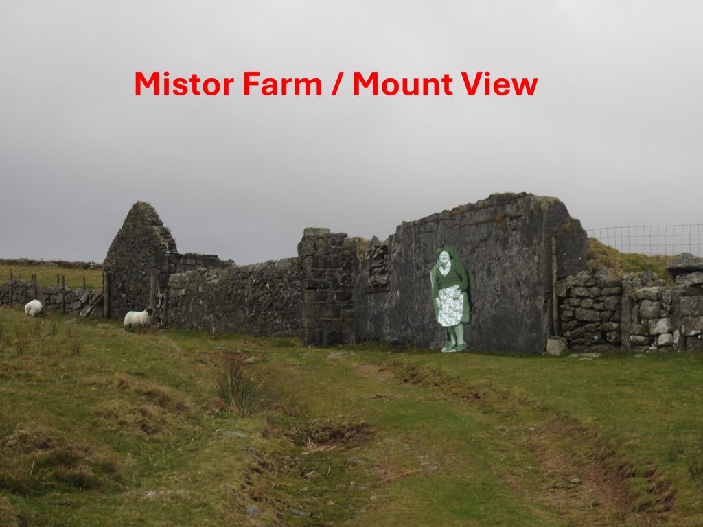
Sketch map of the buildings and features covered in this post. Note the footpath (green dashed line) which is the line of Mistor Lane and the Boundary Stones (BS) located along it. Up to 1842 only one dwelling had been constructed here, which was East Wheal Lucky. Of interest is whilst researching for this post, the author has identified two buildings which have been known as Mis Tor Cottage – this is considered in the postApproaching East Wheal Lucky from the B3357 along a short drivewayBuzzard in the fir tree by East Wheal LuckyEast Wheal Lucky – there seems to have been two buildings here; a house and a barn. R.G. Haynes observations from the late 1960’s were: “Two buildings and enclosures south of Mis Tor Cottage. A site within enclosures with gardens and three walled entrances to a farmyard which contains two small dry stone buildings. Both have remains of gables but are quite unsuitable for dwellings. Unusual for so much labour to be expended on a site not meant to be residential”.This structure at East Wheal Lucky is what the author believes was a barn or outbuildingAt the time of the Walkhampton Tithe in September 1842, the occupant of East Wheal Lucky was Dinah Eva. Prior to that she had been living at Holming Beam Farm from around 1836 to 1840. She had at least two children Mary and Susan in the 1830s and was married to Joseph Wills, who was a miner who had been working at Holming (Omen) Beam Mine. A granite roller amongst the ruins at East Wheal LuckyA second granite roller amongst the ruins at East Wheal LuckyClose up of what was presumed a barn or outbuilding. After Eva’s House (adjacent to Mistor Lane) had been constructed, this building (and possibly the house) was known as Eva’s cart sheds (ref: Photograph on page 90 of ‘A Book of Princetown’ by Gardner-Thorpe). The ‘Eva’ from Eva’s House was Ann Eva not Dinah EvaThe main dwelling at East Wheal LuckyDoor step or more probably a lintel at East Wheal LuckyInside the main dwelling at East Wheal Lucky. The dwelling appears still to have been roofed in 1892 according to old OS mapsLooking south from the main dwelling at East Wheal Lucky. The ‘cart sheds’ (for Ann Eva) were used to accommodate both horses and carts. Looking at old OS maps, the barn or outbuilding appears to have still been roofed in 1873 but was roofless by 1892Lane (or drang) between East Wheal Lucky and Eva’s House at Mistor LaneSome of the farmsteads, small holdings and dwellings around Mistor Lane. Note the two dwellings called ‘Mistor Cottage’ (or ‘Mis Tor Cottage’), which are discussed in this postEva’s House next to Mistor Lane. The building is showing on OS maps by 1873, so will have been constructed between 1842 and 1873. The building lies just within (ie to the west side of Mistor Lane) what was Walkhampton parish at that time. Eva’s House. The family included Eli, Charlie, Bert, Sam, Will, Daniel and Ann. There might have been a connection with Dinah Eva (East Wheal Lucky) but the author is unaware of any.Eva’s House. Regarding the family: Bert Eva became a clerk at the prison; Daniel worked at the sand pit at Greeny Ball (aka Long Plantation); Sam was a cook and photographer (taking identification photographs at the prison). Eva’s House was still shown as being roofed on the 1954 OS map.Writing in May 1968, Haynes wrote of Eva’s House: “….a small cottage with outbuildings abandoned in recent times, standing to gable peak at chimney end. Stands on the track to mis tor farm, with garden and enclosure. The house is mortared and slated”. This suggests perhaps that the house had been occupied for around 100 years – circa 1860’s to 1960’sThis picture was given to the author by Simon Dell from the Don Youngson collection, where it is labelled “Mistor Cottage with Fanny Hext”. That said, the same picture appear in ‘A Book of Princetown’ and is labelled “Ann Eva with a dog outside her cottage (Eva’s House) in Mistor Lane, pictured before the Duchy added a kitchen on the south side in the 1940’s”. Other pictures obtained by the author suggest that Mistor Cottage was far larger that Eva’s House and had two chimneys compared to one shown in this photograph. By examining the OS map from 1949-74, the confusion over the the naming of Eva’s House may be solved. It would seem that Eva’s House (as annotated in ‘A Book of Princetown’) was later called Mis Tor Cottage. Hence, the previous black and white photograph may be correct for both annotations (except the name of the lady outside the dwelling) ! NOTE: In ‘A Book of Princetown’ the building to the west of Mistor Farm has been called Mistor Cottage – quite confusing but appears to solve the mystery. To assist and add to the story, it is known that the Youngson’s lived at Mis Tor Cottage (Eva’s House) – Alec and Pansy and their son Don. Pansy later moved to Mistor Farm (mount’s View) when Alec died (in an accident at Grey Dawn Quarry, near Merrivale).Structure within the walling of Eva’s House and surrounding fields. In this area it is recorded that there was a site of a Second World War searchlight battery, this was known as searchlight battery no. BXJ 3. It was manned by 382 Searchlight Battery. It is recorded to have been located at Rendlestone at SX 572752. This grid reference would place it within the fields of Eva’s House. The balance of probabilities suggests this is Eva’s House not Mistor CottageThis boundary stone measures 1.2 metres high, 0.4 metres wide and 0.3 metres thick. It lies within a small field next to Mis Tor Lane and there is no obvious inscription. It represents the boundary of Dartmoor Forest (Duchy) and Walkhampton Parish from circa 1867.Zoomed in view of ruined farm buildings at SX57346 75266. Described by Haynes in May 1968 thus: “Approached by a lane the cottage track, with remains of ancient enclosures. Two main rooms with a possible small room at the north end. Stone edged platform before the house. Probably not a dwelling house”. There were two buildings here still roofed in 1873 but were roofless by 1892. No structures appeared here in the Tithe from 1840’s. The buildings were located with the Dartmoor Forest (Duchy Land).Ruins of Sam Pengelly’s House in a field behind Ivy Cottage. Pengelly had two sons (David and Patrick) and two daughters (one of whom was called Maureen). There were plans in 1912 for the Duchy to replace the house but the author is unaware if this ever took place.In the ‘Book of Princetown’ it is stated that an Ambrose Williams applied to build on land behind Ivy Cottage, which had formerly been held by his father Joel. The application was made on 9th March 1880. On 19th July of the same year he (Ambrose) was granted two acres at a fee of £2 2s 0d and the lease was engrossed on 19th November. It is thought the building constructed is thought to have become Pengelly’s House. That said, an 1873-1888 OS map shows this building had already been constructed.On 10th May 1858, a Joel Williams who was a stonemason applied for a licence to build a house with gardens. He was granted the licence for a plot of just over 3 acres. His plans showed a three-bedroomed cottage with three fireplaces. The picture shows the moorland side of the house which was built, Ivy Cottage. The picture was taken from near where Pengelly’s House is located.By the time of the 1861 census, Ivy Cottage had been built. Apparently Ivy Cottage only survived from the mid-20th century by virtue of its use by a neighbouring farmer as a pig shed before it was reinstated as habitable accommodation.Between Ivy Cottage and B3357 there was a house called ‘Rook’s House’. Note the short lane and drystone walling in the photograph. Photograph was taken from near Rundlestone Corner. Three spinster sisters; Ellen, Bess and Minnie Rook occupied the house with their two brothers, one of whom was called Arthur.Short land leading to the ruins of Rook’s House. The plot comprised the main house and a small rectangular outhouse to the west. The main house was a large four-bedroomed property situated to the east of Ivy Cottage. The earliest known mention of the dwelling was 1st April 1891, when a licence was issued to rebuild a house which had been their previously. The lease in September 1891 was extended from 41 years to 60 years. Heading back up Mistor Lane, to the north of Eva’s House the substantial ruins of Mistor Farm which was also known as Mount’s View. Haynes recorded in May 1968: “The dwelling house of this farm has been demolished, possibly by explosives and left as an enormous pile of featureless rubble. Only part of the west wall remains. The shippen is still in use however as a cowshed. The site was abandoned in recent years. Shown as still roofed on 1954 Ordnance Survey”. The last tenants were the Youngson’s (Pansy and her son Don) in 1960, after which Mistor Farm (Mount’s View) was demolishedA 1939 record of Alexander and Pansy Youngson at Mistor Farm, which was also known as Mount View. Unfortunately, Alexander had a fatal accident at Grey Dawn / Grey Down quarry in 1944An image of Pansy Youngson (taken when she was outside Red Cottages / West View Cottages) superimposed outside the ruin of Mistor Farm / Mounts ViewMistor Farm / Mount’s View on the Dartmoor Forest (Duchy) side of Mistor Lane was constructed on a 20 year lease. Water for the farm was carried from a spring to the east until a concrete tank was installed which was fed from the prison fields.Mistor Farm / Mount’s View shippen. Into the 21st century, this building still had a galvanised roof.Mistor Farm / Mount’s View from the north looking down Mistor LaneTo the north east of Mistor Farm / Mount’s View there is a collection of ruins, which were Chip Hext’s House.Lane leading to Chip Hext’s House. Chip Hext was a farmer / monumental mason who kept cows and a pig. Chip Hext’s House. Haynes visited in April 1968 and wrote: “One of several houses with enclosures north of Rundlestone. Probably built and enclosed in the late 18th or 19th century and abandoned in recent times. A sizeable farmhouse with numerous outhouses. The dwelling house is mortared and partly floored with cement. Very dilapidated”. The northern farmsteads, small holdings and dwelling adjacent to the mid / upper section of Mistor LaneAlong a short lane west from Mistor Farm / Mount’s View some more ruinous buildings can be found. These ruins are referred to as Mistor Cottage in ‘A Book of Princetown’Probable barn, part of the Mistor Cottage complexInside the probable barn, part of the Mistor Cottage complexThe probable ruins of Mistor CottageIn ‘A Book of Princetown’ (page 88), it is recorded that Sidney and Clara Hext lived here, with later Bernard Hext being born here. Bernard worked at a bakery, then at Merrivale Quarry before embarking on a career on the railway.This picture was taken in 1948 and is from the Don Youngson’s collection. It was labelled as being outside Mis Tor Cottage which might have been the dwelling known as Eva’s House or the dwelling along the lane opposite Mistor Farm. The people in the picture are left to right: Eli Eva, Chip Hext, Fanny Hext, Cecil Hext and a young Don Youngson. In the balance of probabilities, the author suspects this was outside the dwelling also known as Eva’s House.Haynes visited in April 1968 and recorded: “A sizeable farmhouse with numerous outhouses. The dwelling house is mortared and partly floored with cement. Very dilapidated”. The two ruined buildings at Mis Tor Cottage complex. The dwelling house in the foreground with the barn in the background (mid/upper left)Picture and story supplied courtesy of Dartmoor Chris. The picture is Mis Tor Cottage – Insert: Philip John Harding, the 2½ year old victim of a tragedy on 18th August 1932. The unfortunate tragedy relates to a Dartmoor labourer, Richard Samuel Hatch, aged 27 of Mis Tor Cottage, who was found guilty of manslughter of the young victim Philip Harding, who was his stepson. Which ‘Mis Tor Cottage’ this is is not known.Mis Tor Cottage west end with barn behindWest end of Mis Tor Cottage with the distant Staple Tors and Pew Tor beyondThe lane from Mis Tor Cottage to Mistor Lane One of the 1867 duchy / walkhampton boundary stone with Great Mis Tor in the backgroundIn order to get photographs of the east side of the Mistor Farm enclosures, the gate and adjacent stile shown in this picture should be accessed. On this corner there is an inscribed stone. In 1867, the prison boundary was extended by a further 1000 acres under a new lease. With this new boundary a new series of boundary stones were erected, this time not only with a ‘broad arrow’ but with the initials D.C.P which stands for Directors of Convicts Prisons. This Director Convicts Prison Stone can be found on the north west boundary of Mistor Farm enclosure and Mistor Lane at SX56939 75799Another DCP stone (amongst the reeds) can be found near the north east boundary of Mistor Farm enclosure at SX57168 75861.A DCP stone can be found on the south east boundary of Mistor Farm enclosure at SX57261 75683A DCP stone can be found on the south west boundary of Mistor Farm enclosure at SX57128 75638East side of Mistor Farm enclosure with ruins of outbuildingsChip Hext’s House looking from the eastChip Hext’s House with the line of Mistor Lane (walling) beyondField line from the Mistor Farm enclosures heading south to Rundlestone. Along this line is where the Conscientious Objectors (1917-1919) held at the prison were tasked in digging a ditch for work, which was described as being of ‘National Importance’Photograph courtesy of Simon Dell of Conscientious Objectors from 1918 digging a ditch, which was unusually deep for no apparent reasonPhotograph courtesy of Simon Dell of a Conscientious Objectors ditch. Look carefully and you’ll see Simon’s head (and he was stood on top of a 2ft granite boulder)On open moorland to the east of the Mistor Farm enclosures there is a very straight gully leading over the hillside. This gully is not mentioned on the Devon Historical Environment Record or any other Dartmoor publication the author is aware of. The line of the gully might be an old track but is more probably a drainage channel on this Prison Land. Another view of the gully. As this was on Prison Land, it is possible it might have been dug by prisoners in the 19th century or possibly by conscientious objectors circa 1917-1919. Cyril Sinclair memorial cross – sadly struck by lightning on this spot in July 1983, next to the Prison Leat, near Fice’s Well. 54 year-old Cyril was tasked to clear a section of the Prison Leat to keep the supply of water flowing to the Prison Farm when he was caught up in a storm and struck by lightning. R.I.P CyrilThe cross was installed by Prison Officer Ron Joy and others. A place of poignancy to pay respects when in the areaThe memorial looking north east towards Blacka Brook and the western flank of Holming (Omen) Beam. The memorial is located at SX57580 75623.