A collection of walks, discoveries, insights and pictures of exploring Dartmoor National Park
September 1, 2021
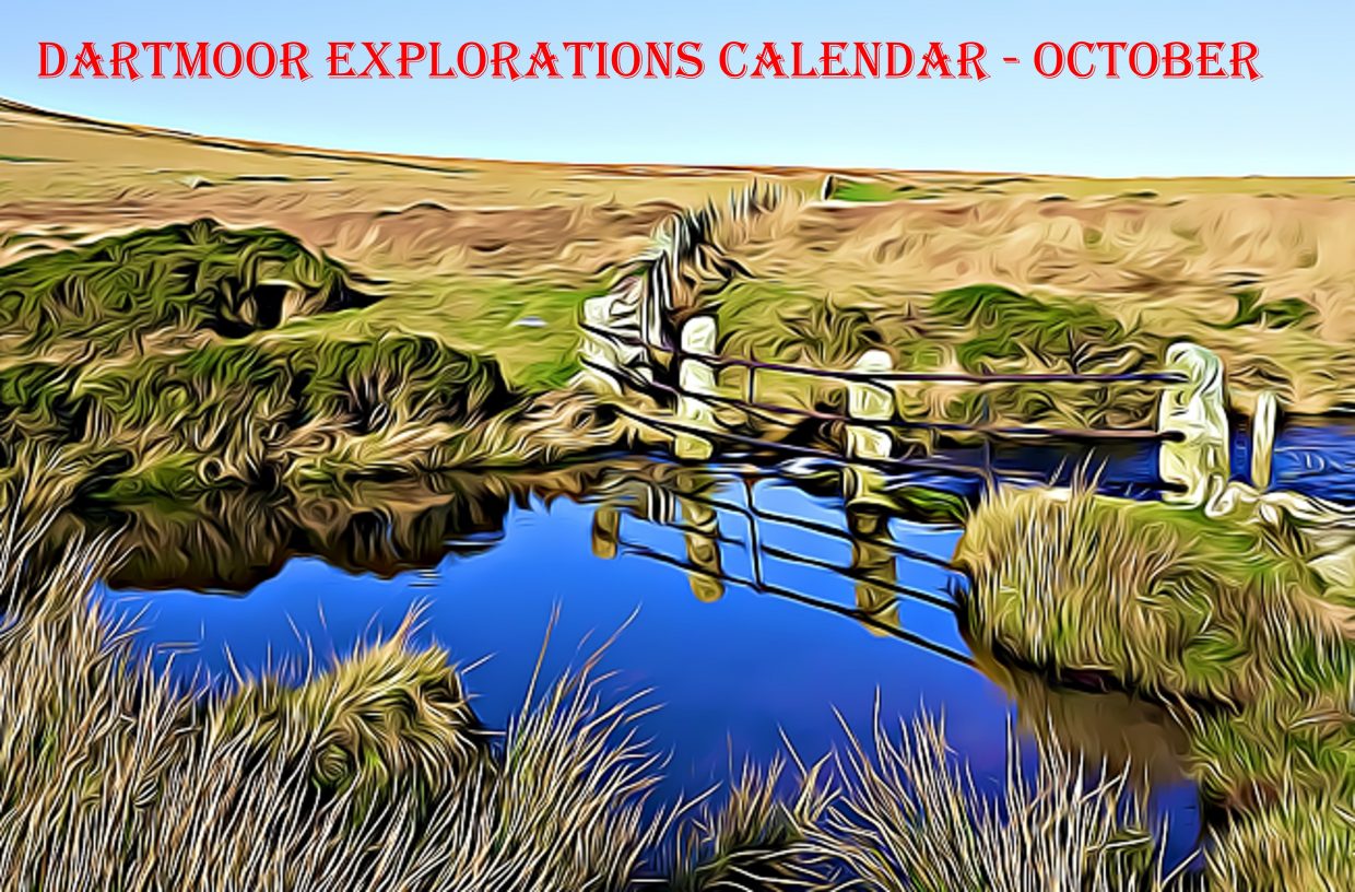
Dartmoor Explorations Calendar – October
In 1991, the Dartmoor National Park Authority (DNPA) published a spiral bound diary to commemorate their fortieth anniversary (1951-1991), called “The Dartmoor Diary”.
Inspired by this publication (and some of the entries in it) and to celebrate the DNPA 70th anniversary year in 2021, the “Dartmoor Explorations Calendar” records an event or story, complemented with photographs for each day of the year.
This page of the Dartmoor Explorations Calendar celebrates October on Dartmoor and its immediate borderland.
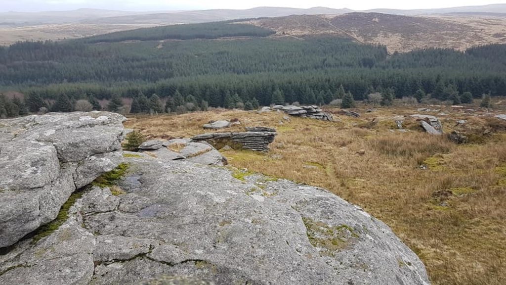
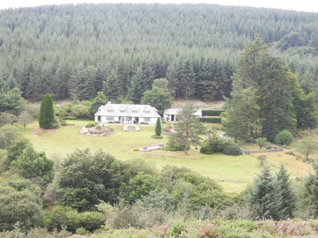
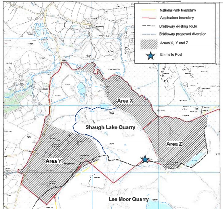
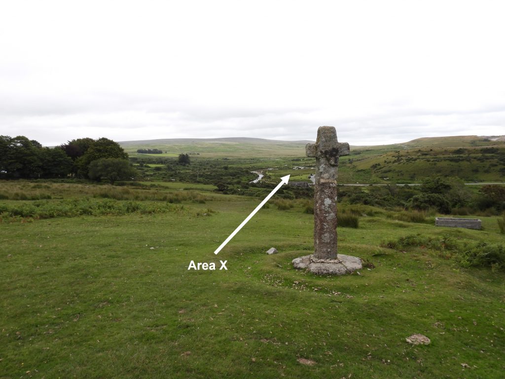
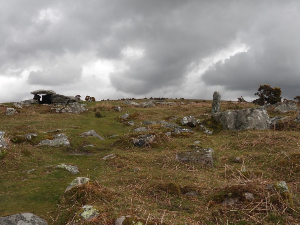
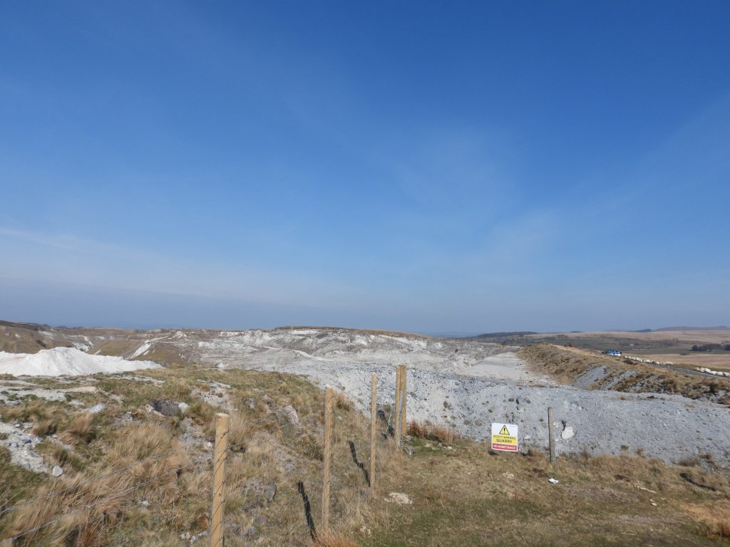
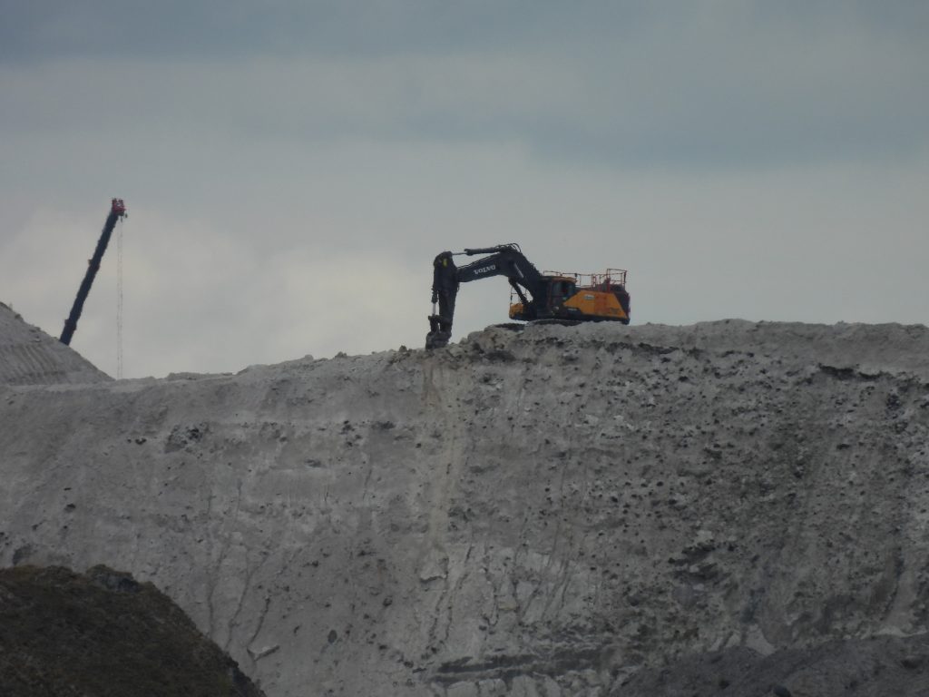
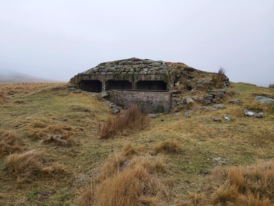
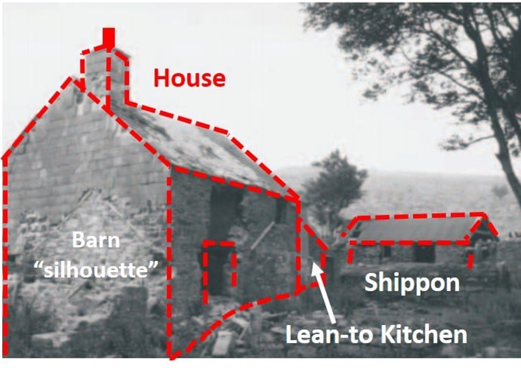
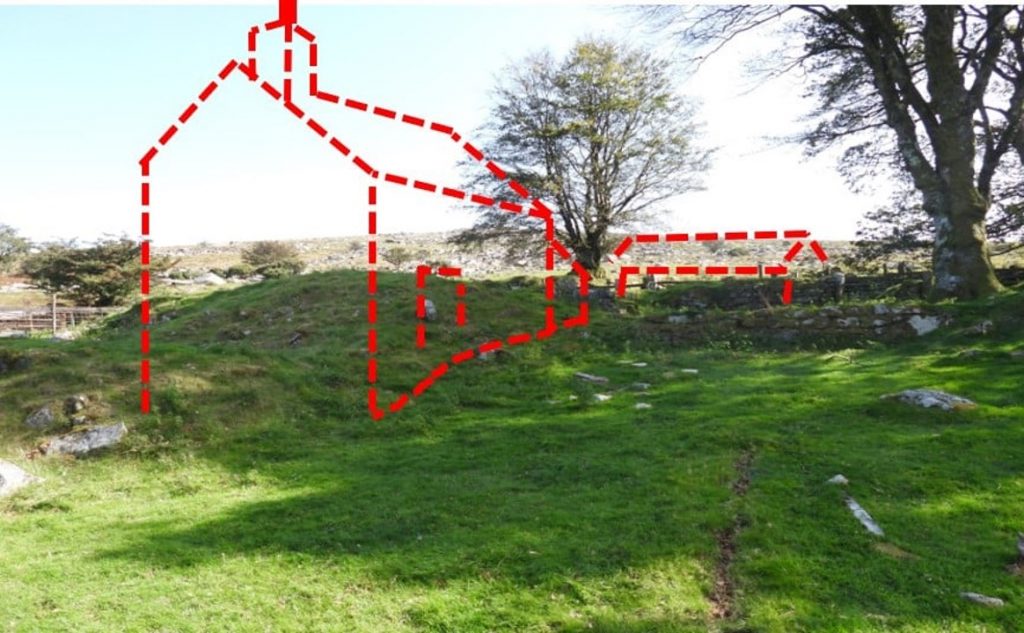
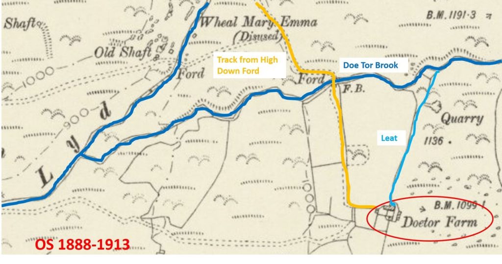
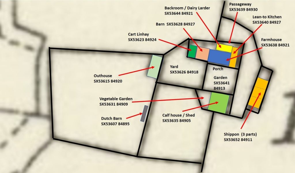
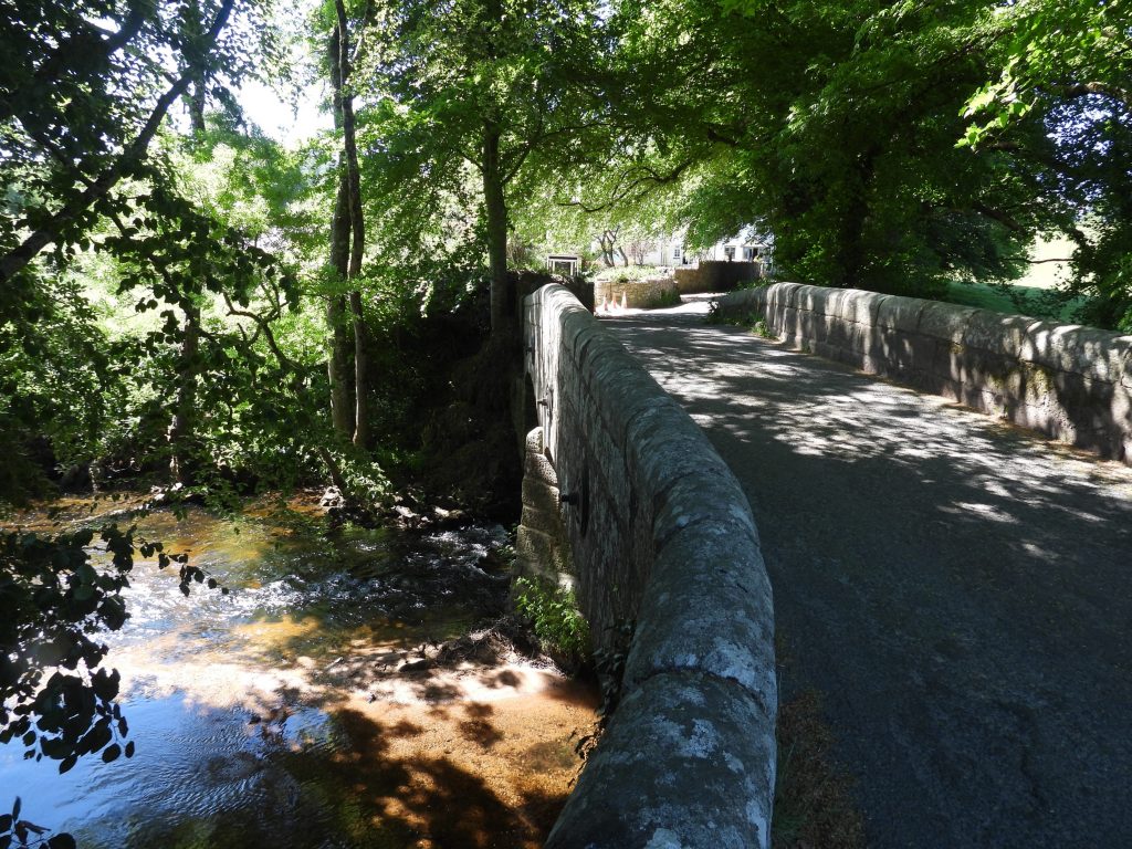
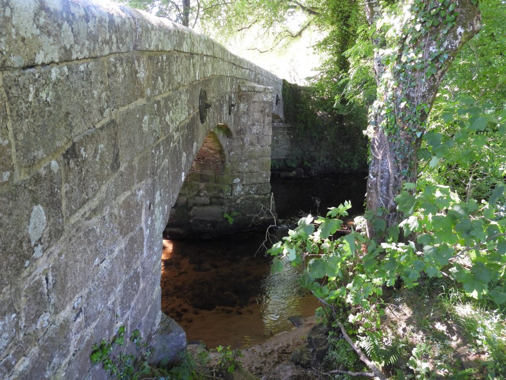
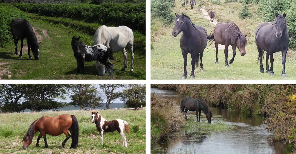
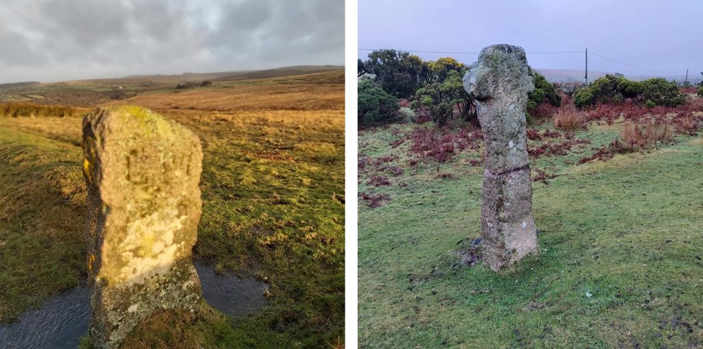
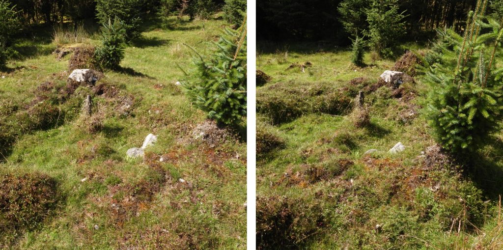
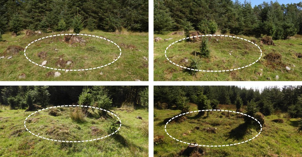
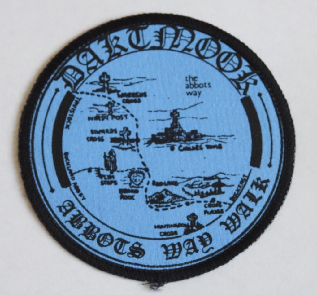
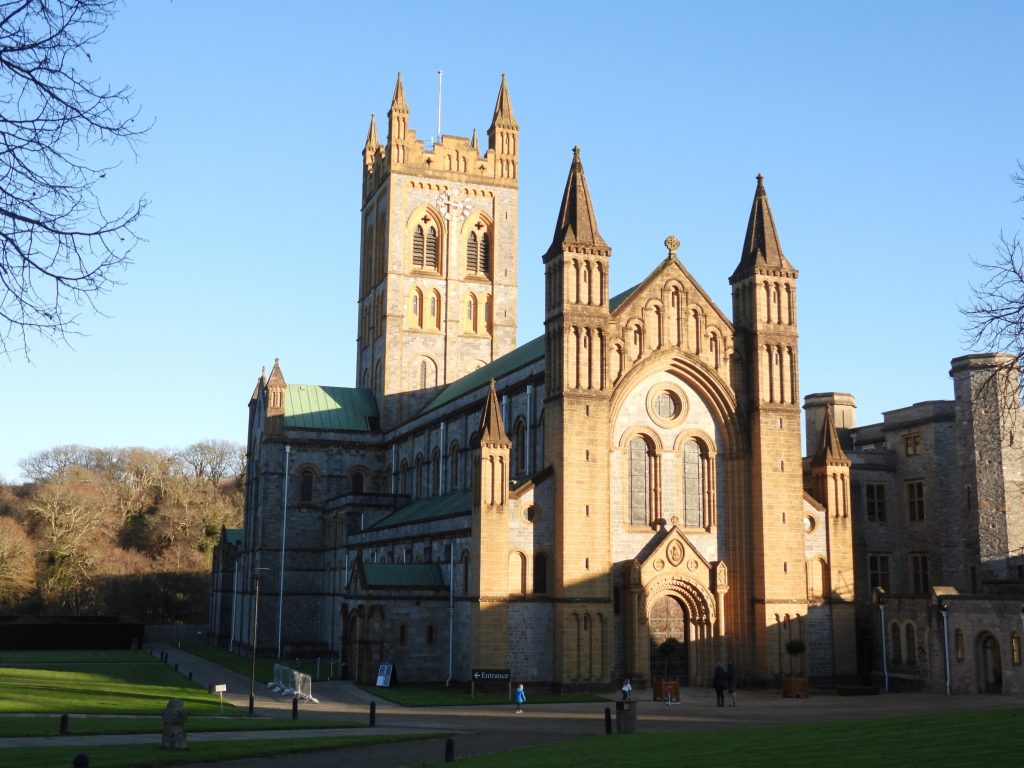
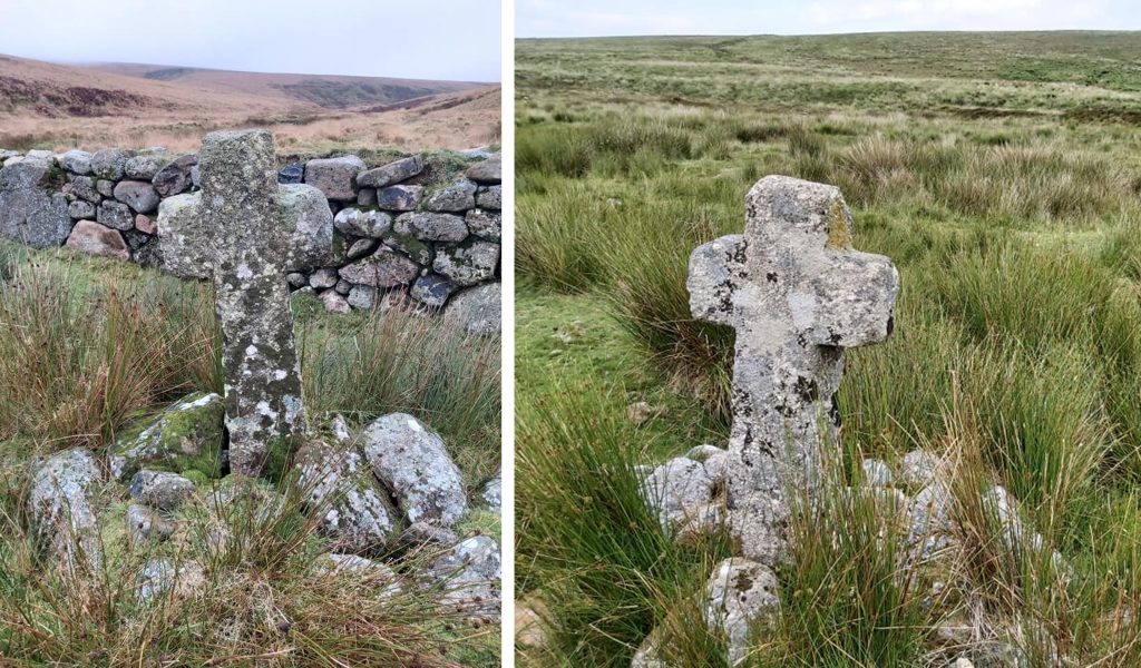
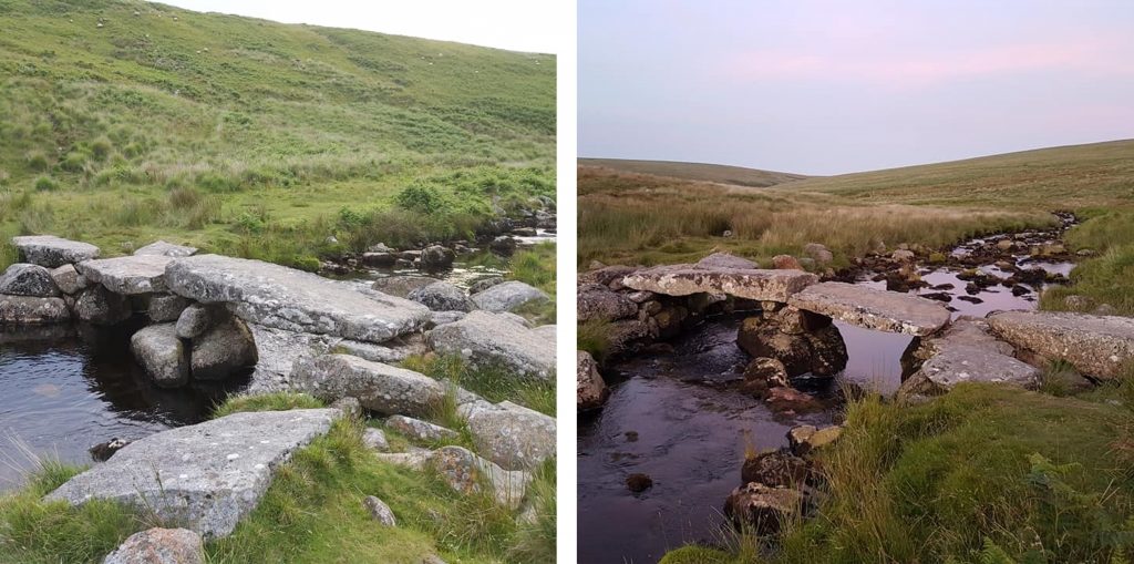
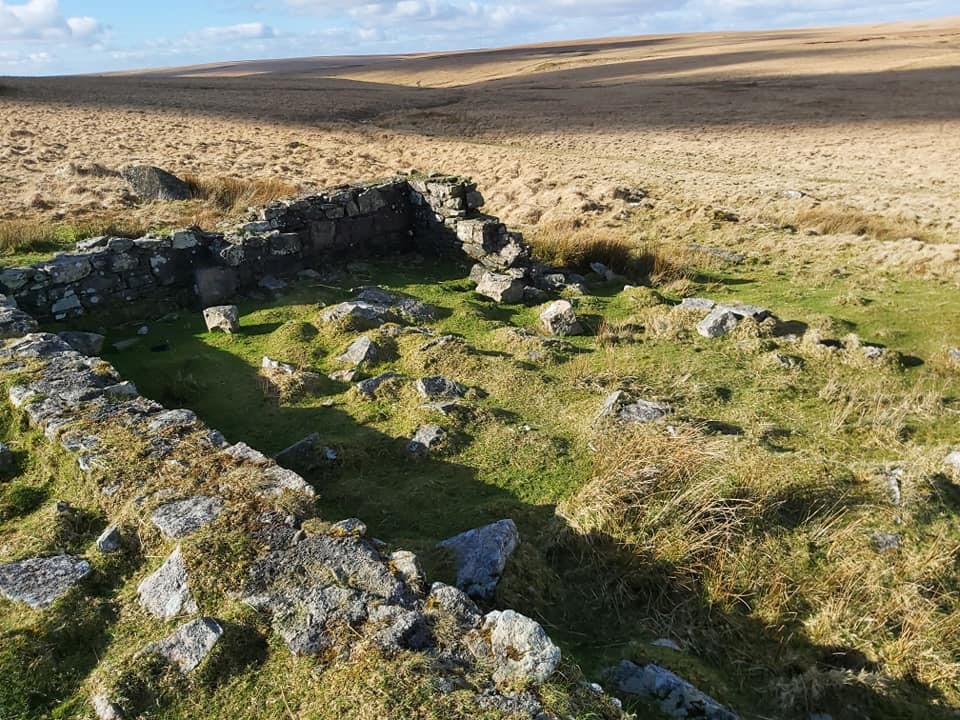
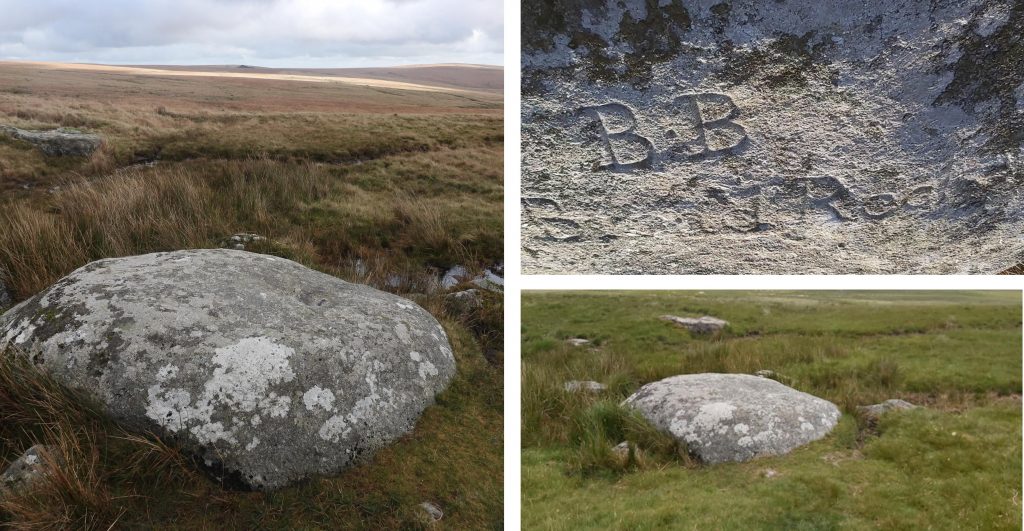
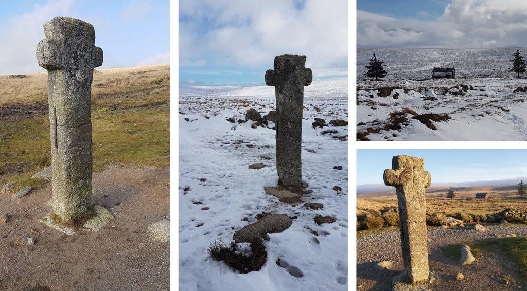
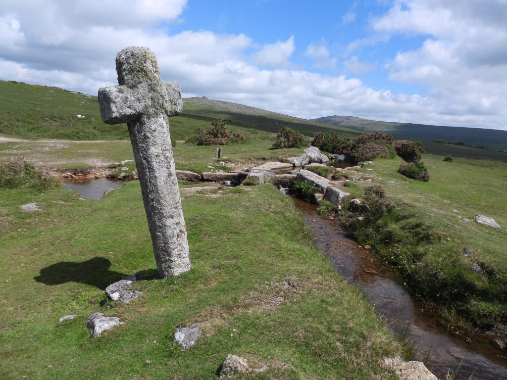
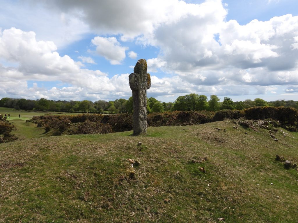
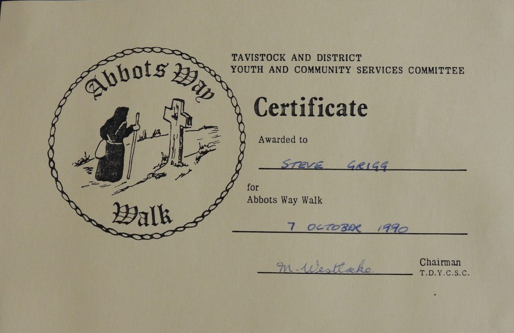
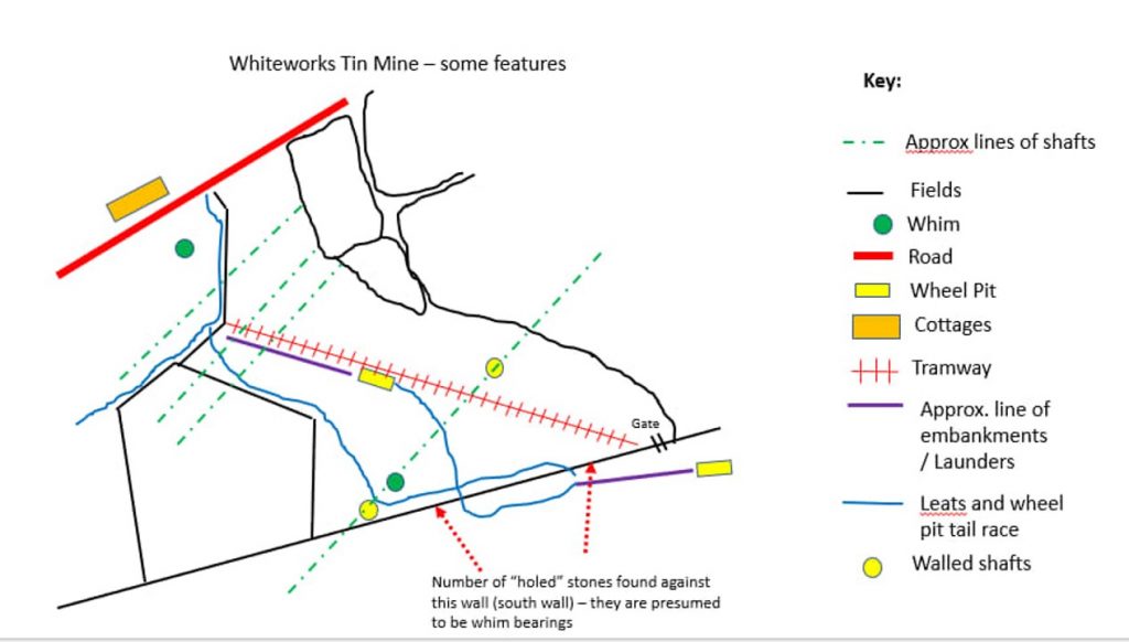
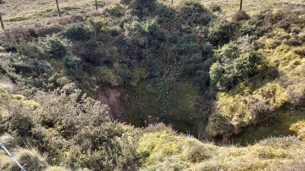
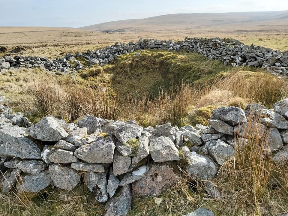
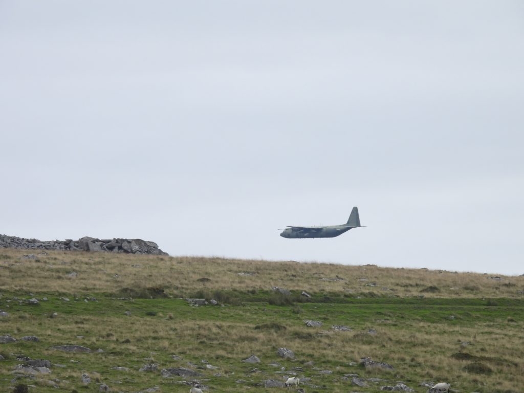
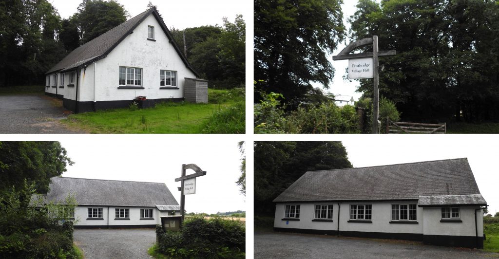
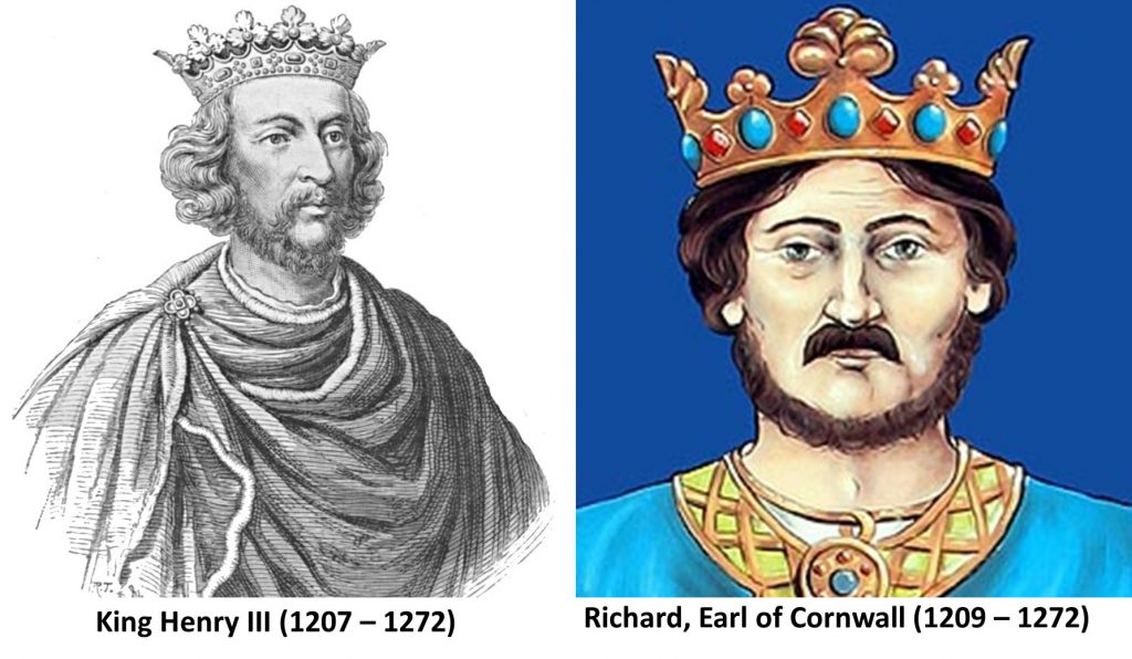
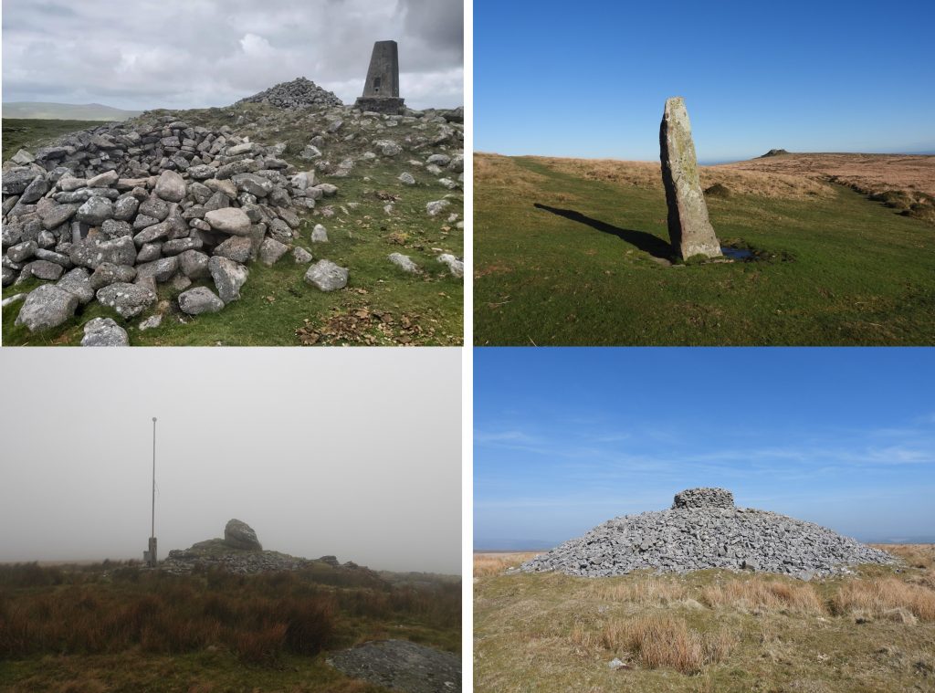
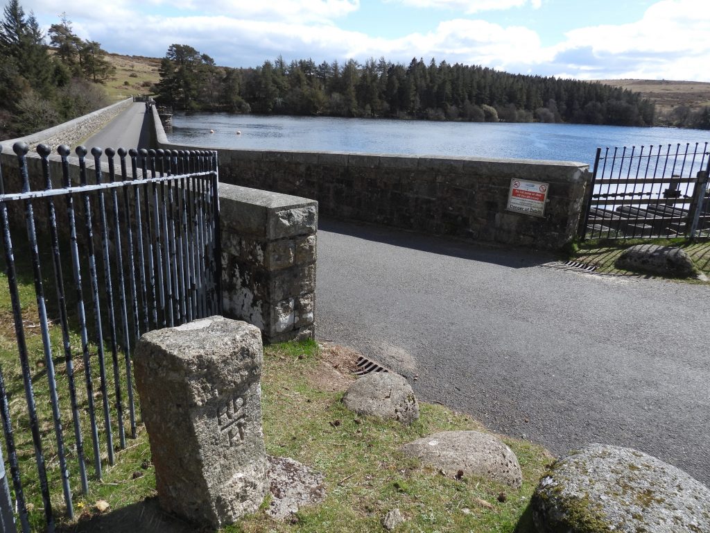
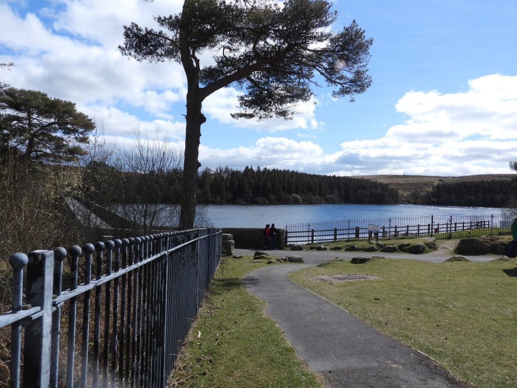
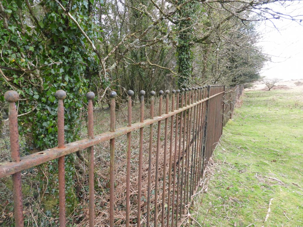
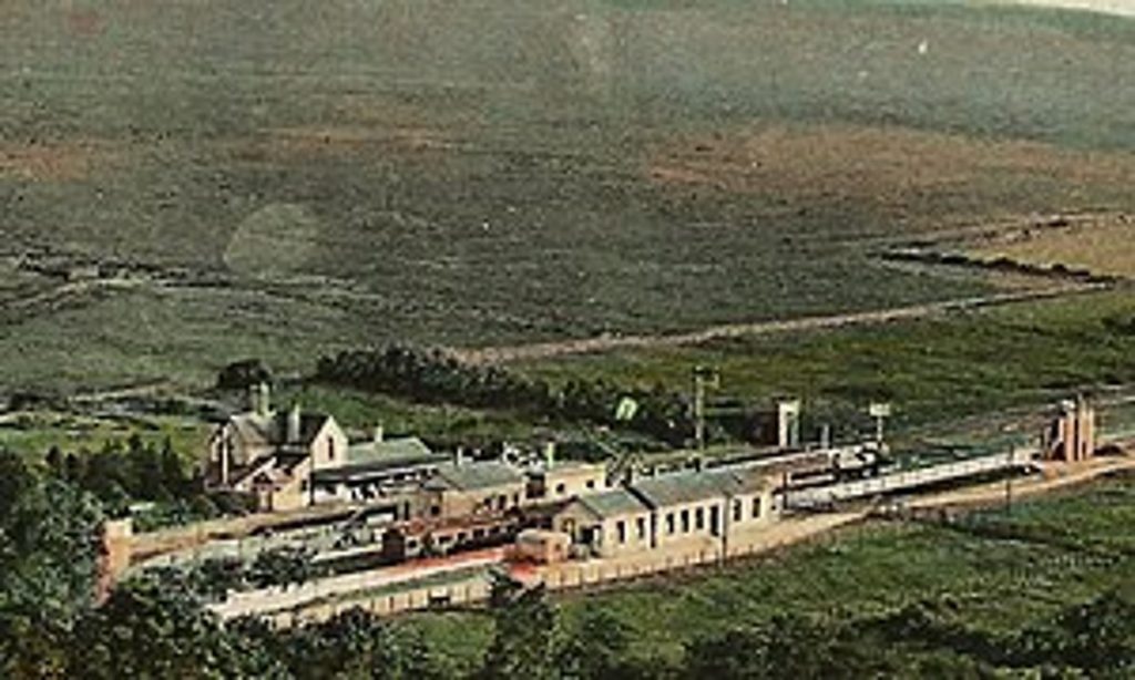
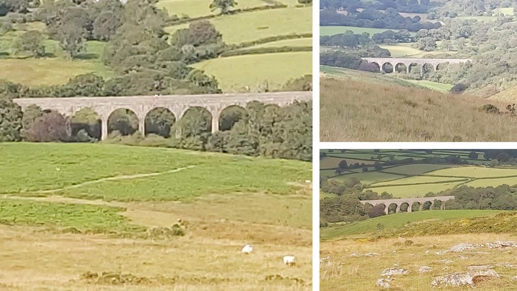
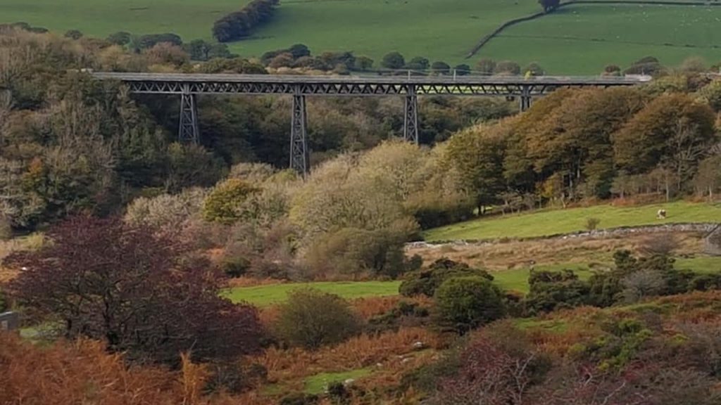
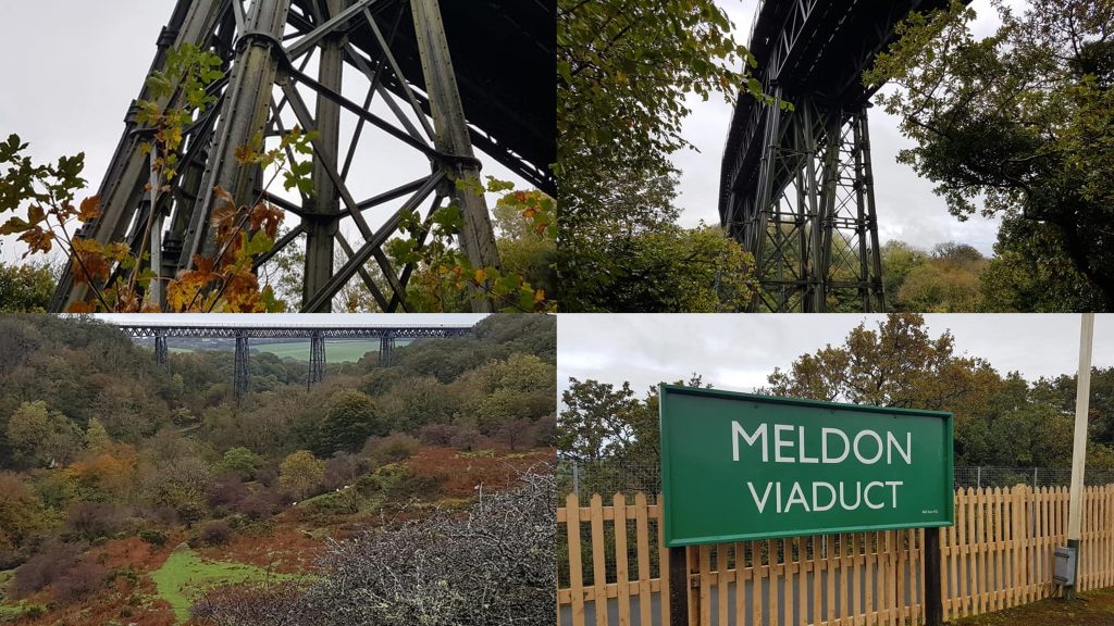
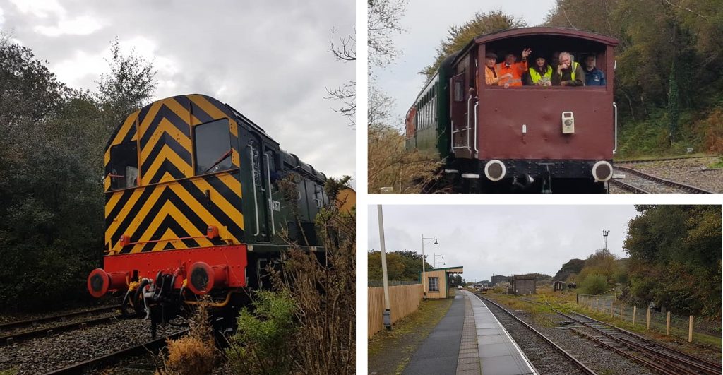
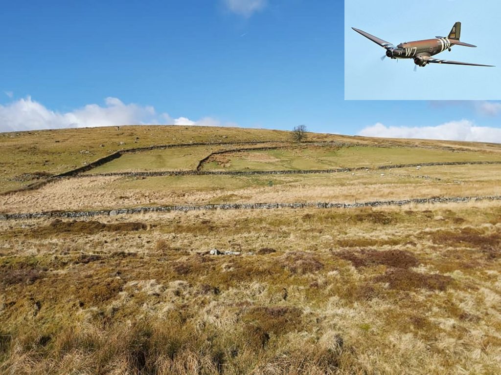
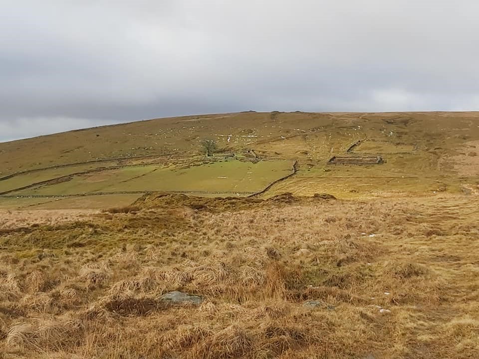
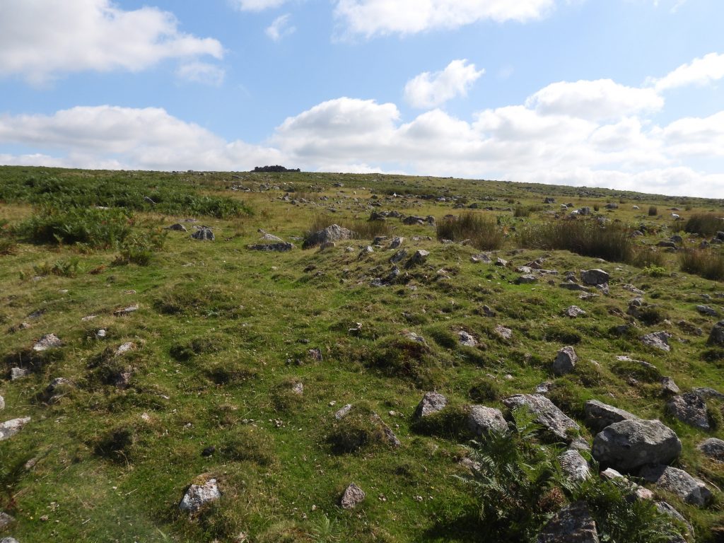
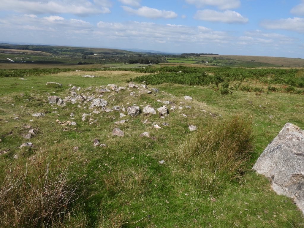
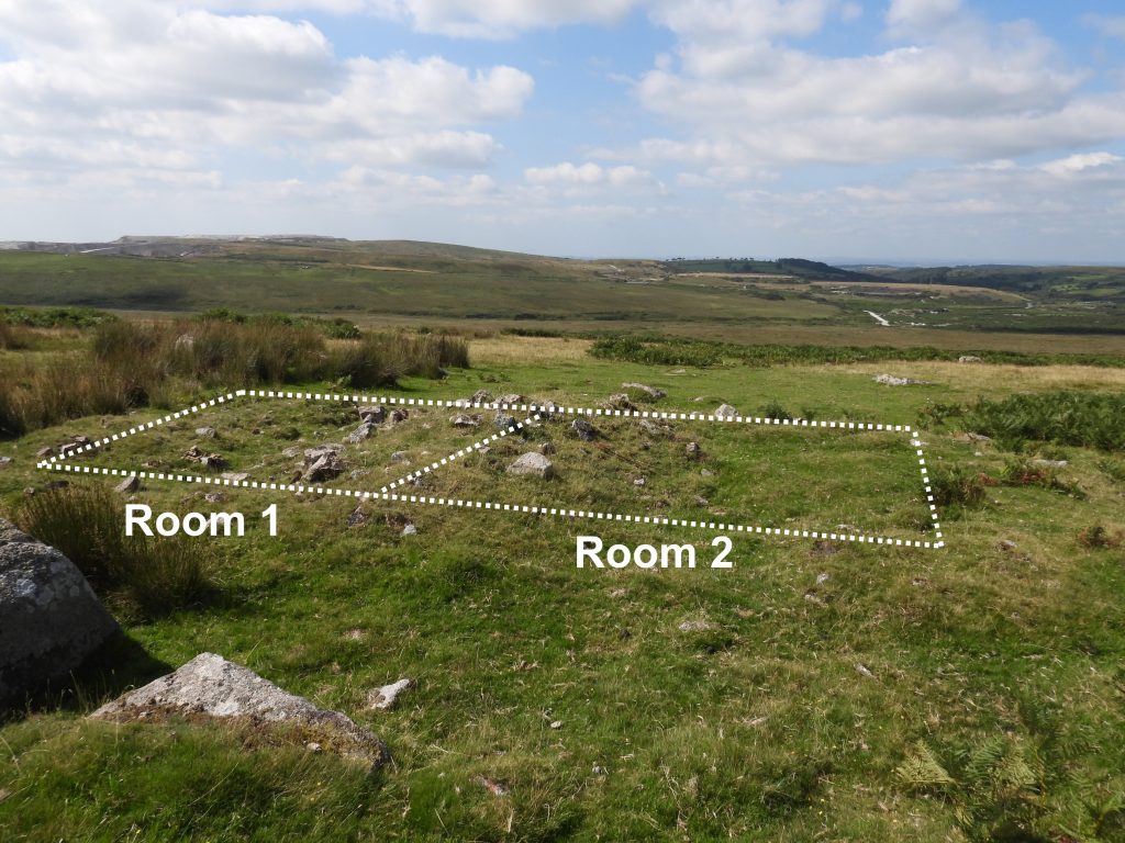
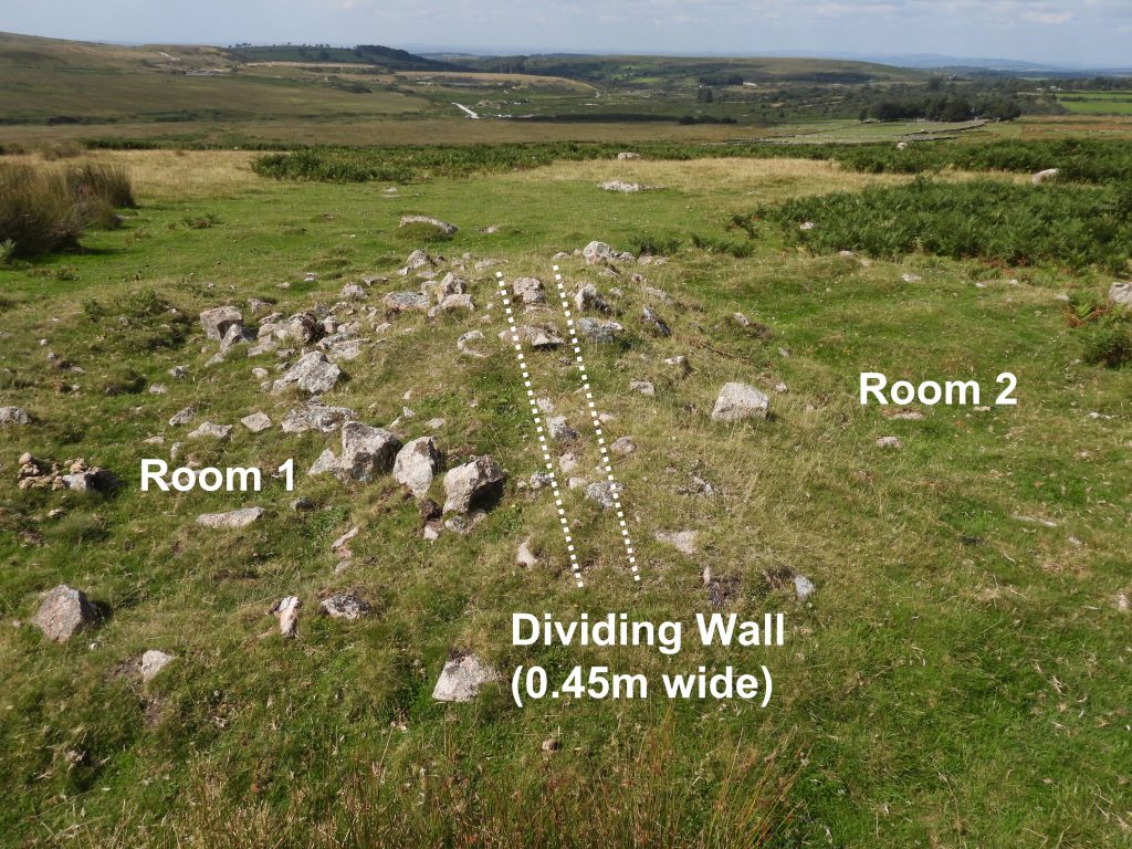
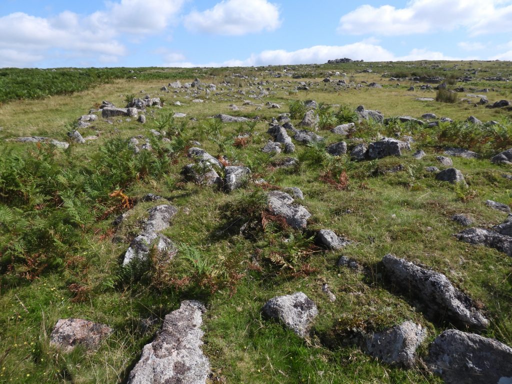
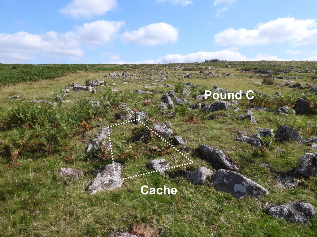
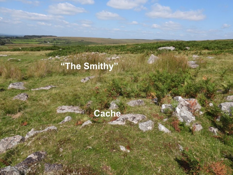
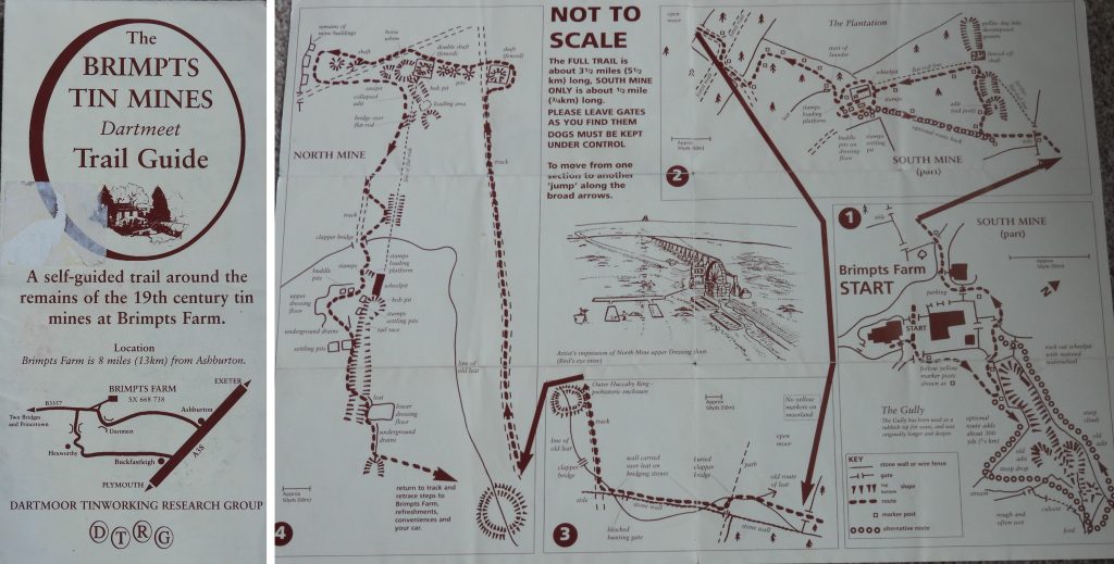
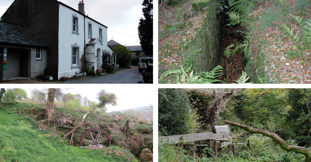
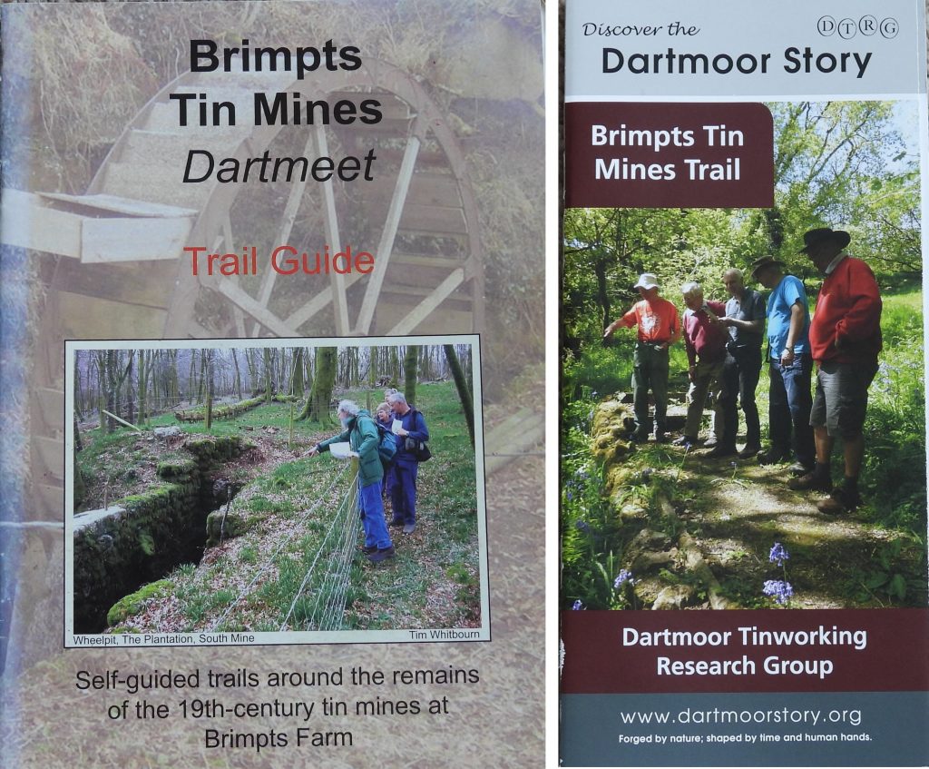
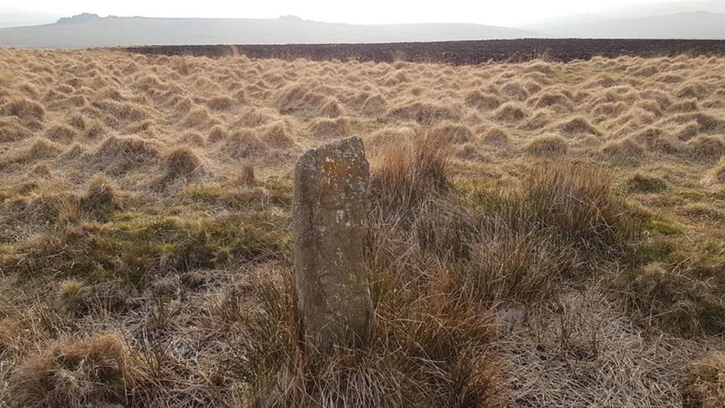
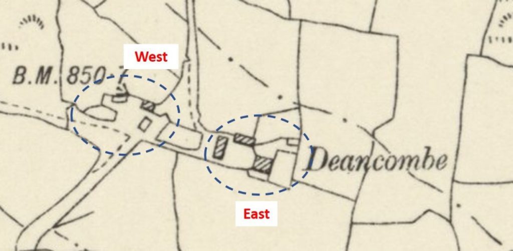
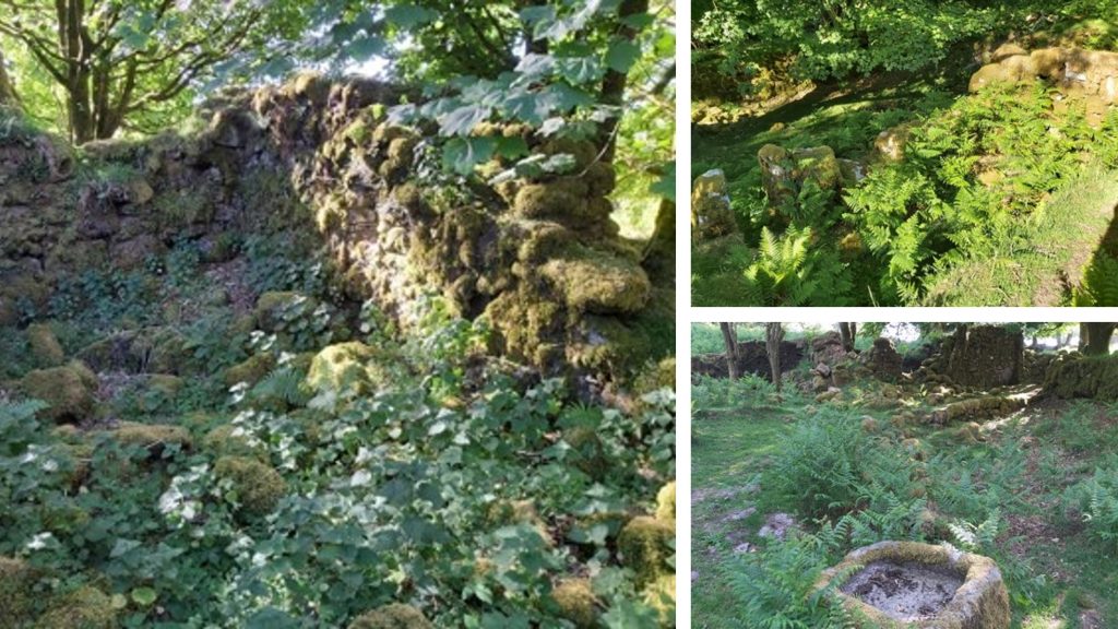
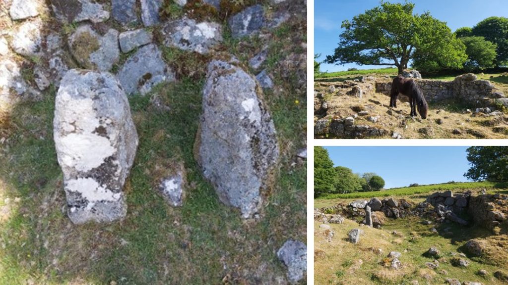
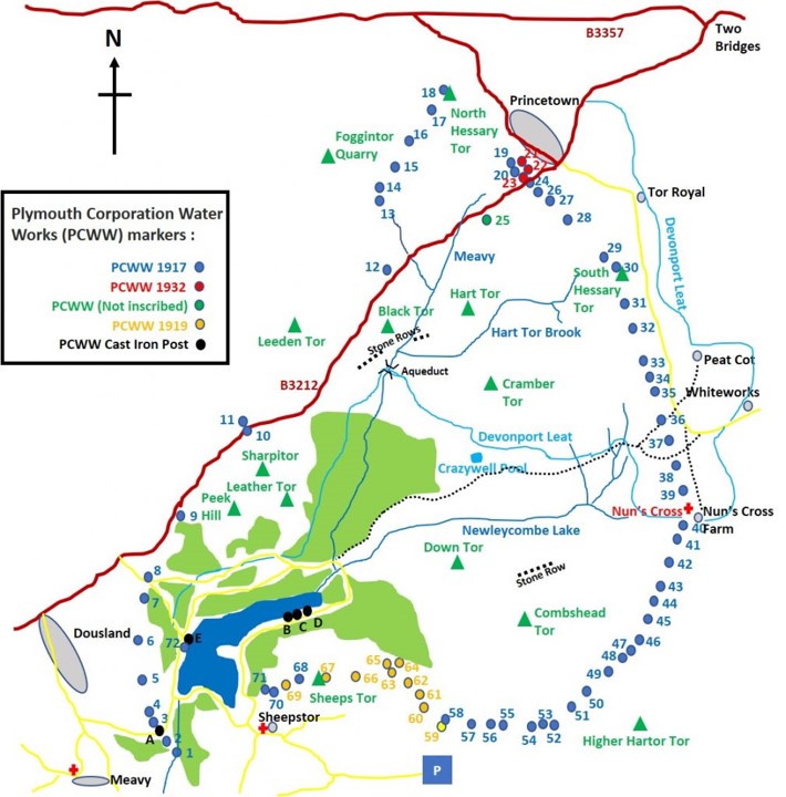
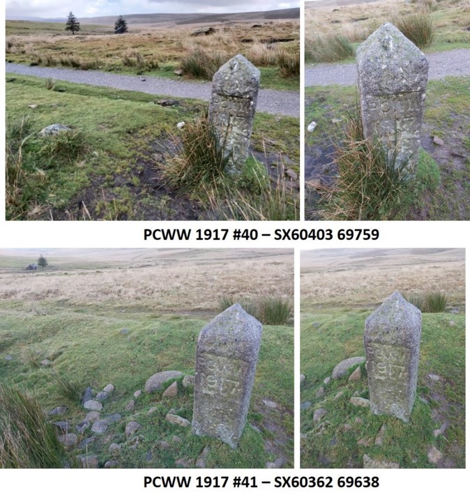
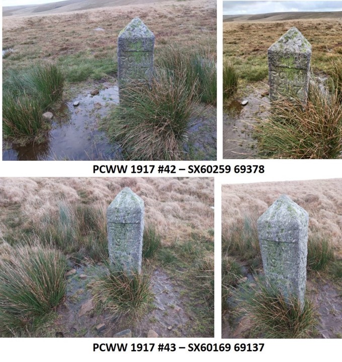
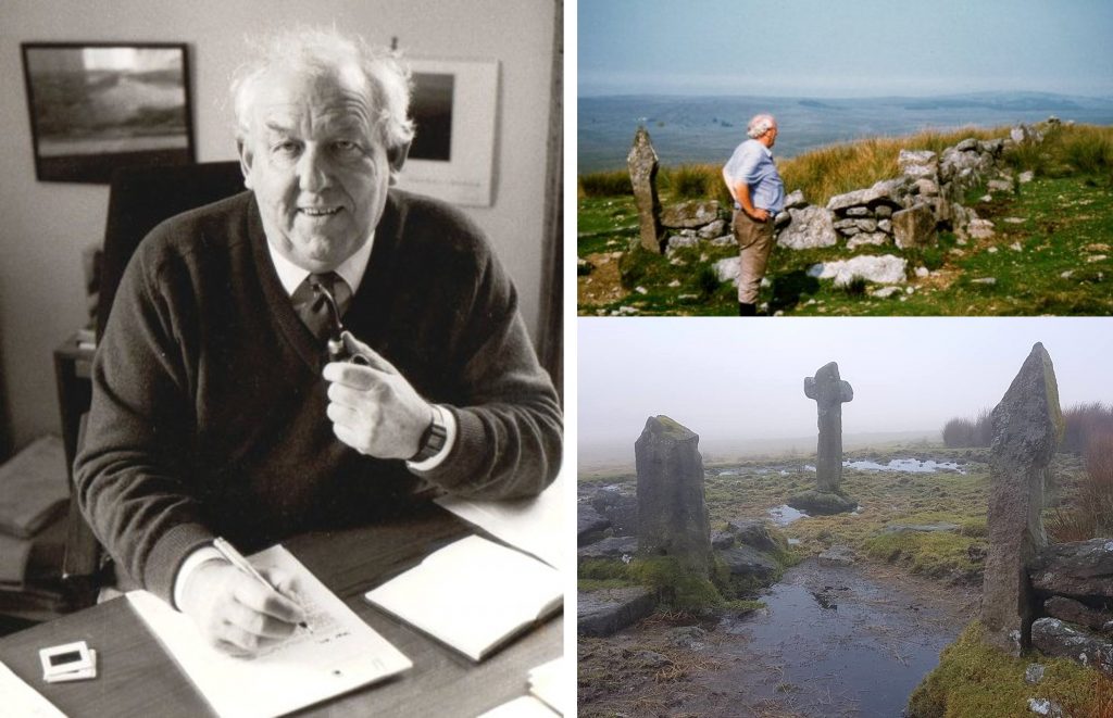
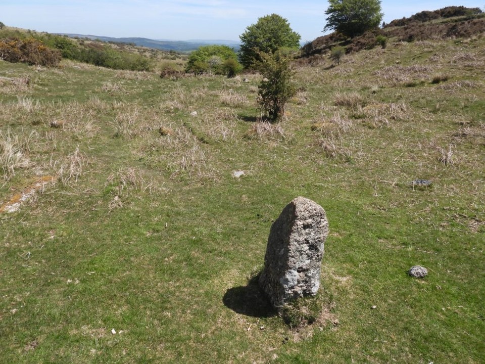
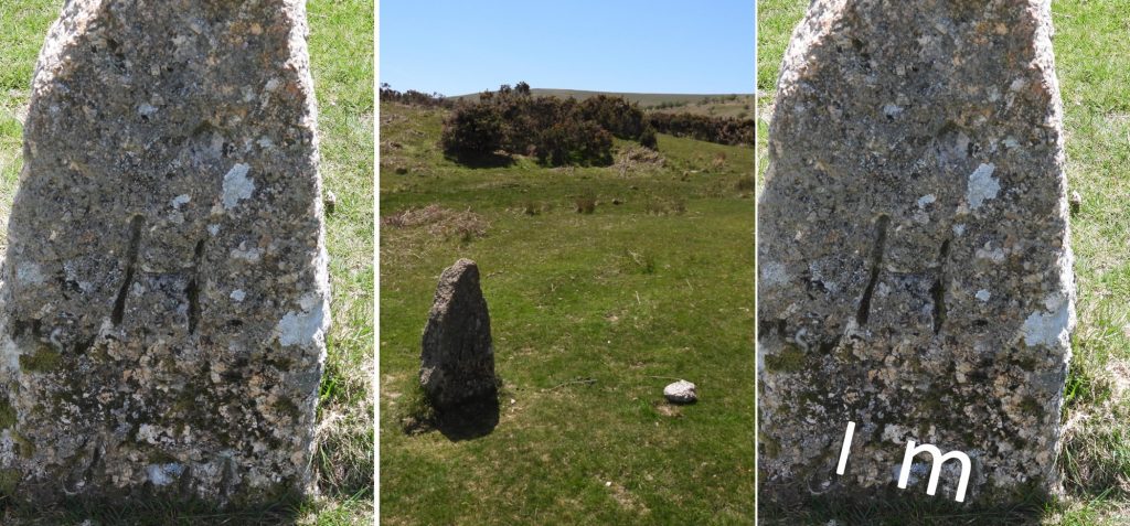
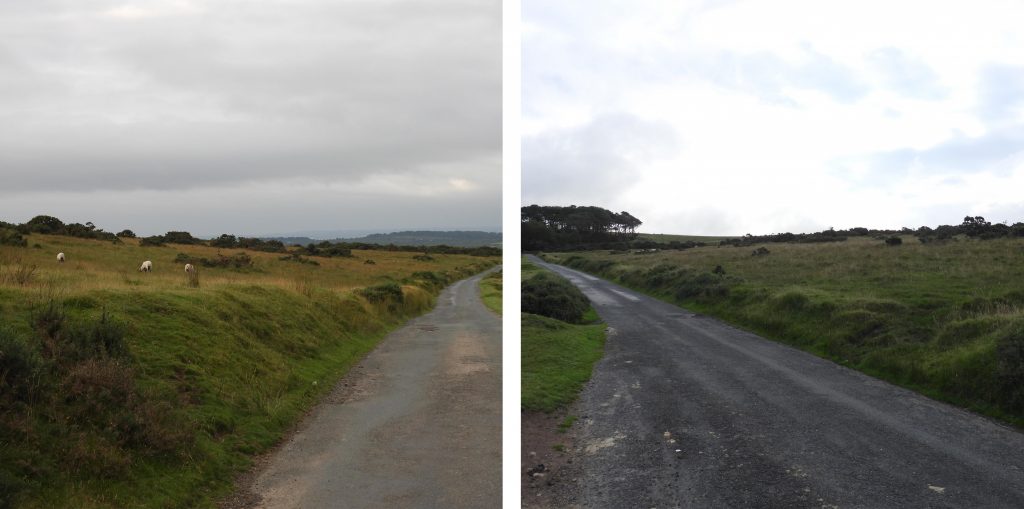
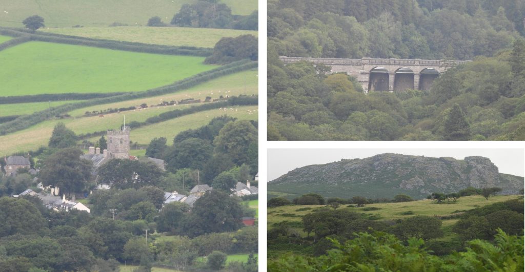
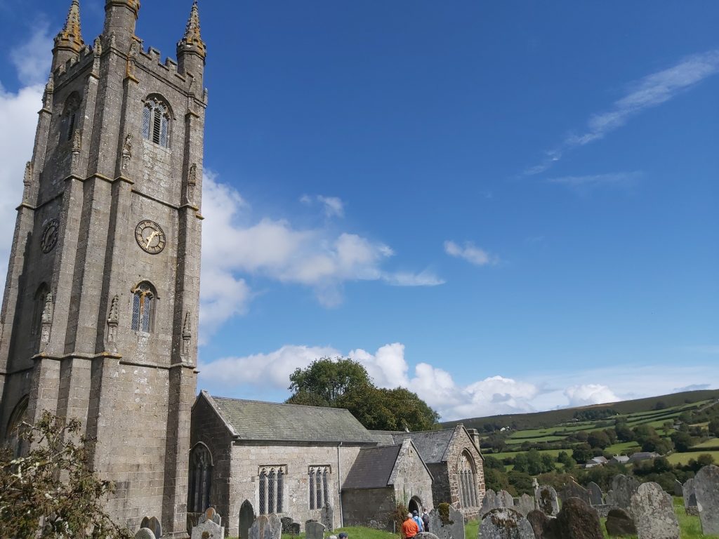
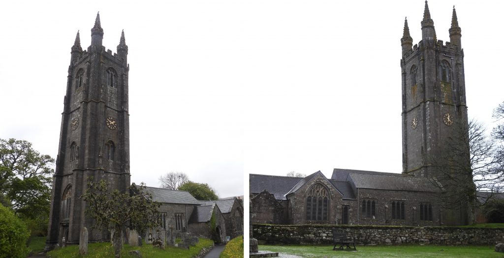
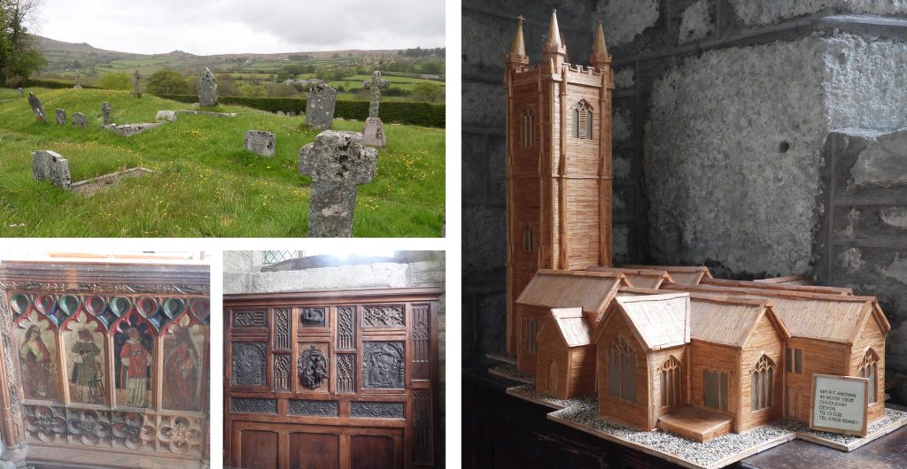
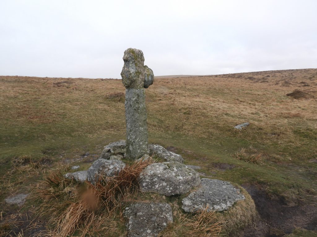
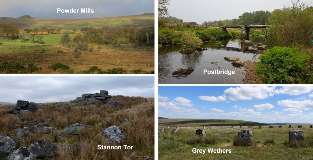
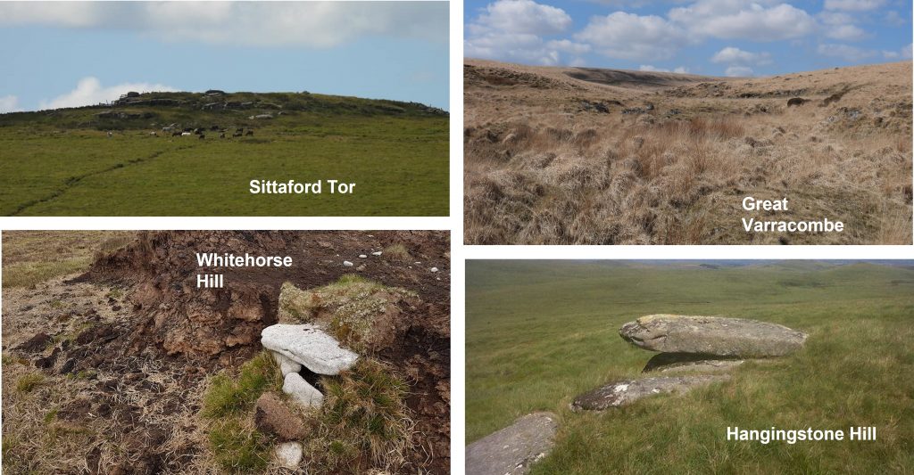
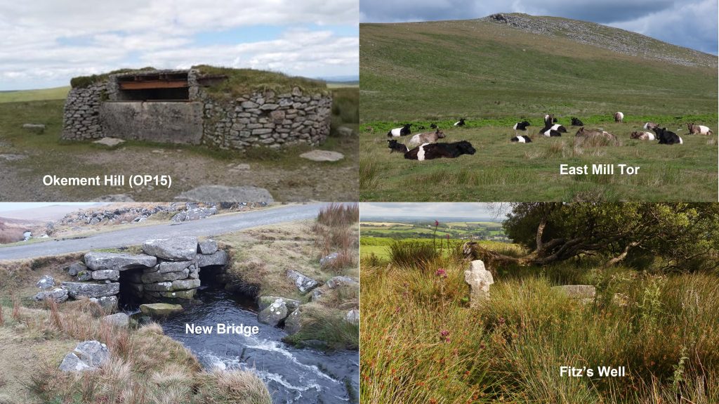
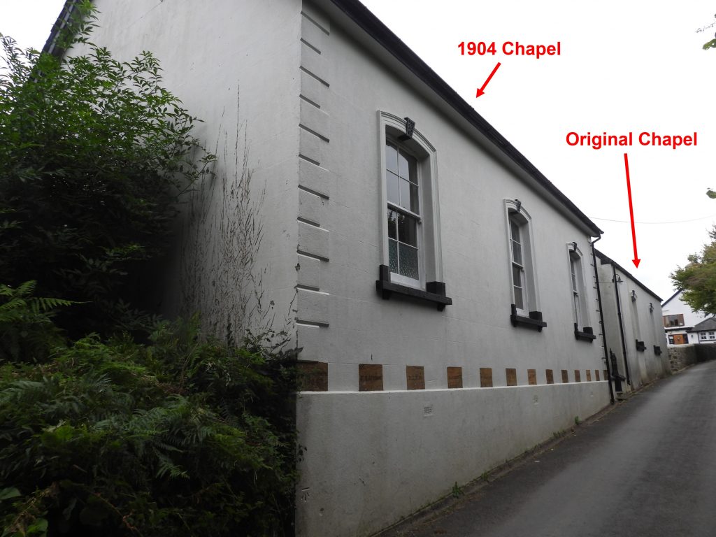
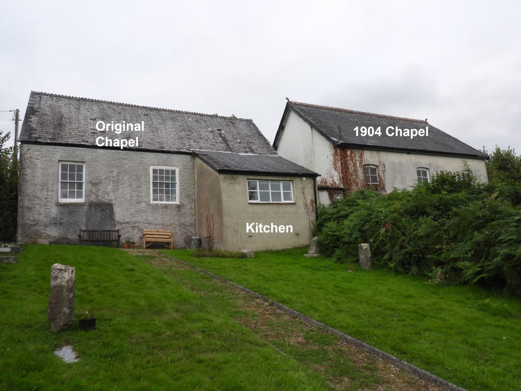
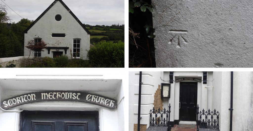
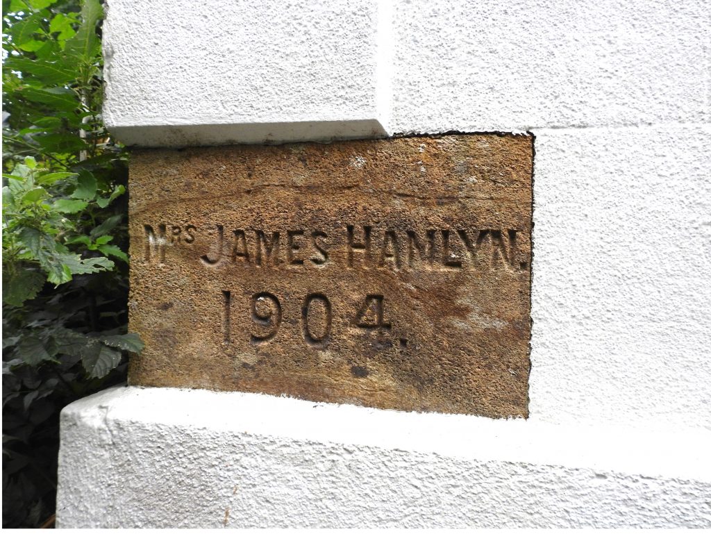
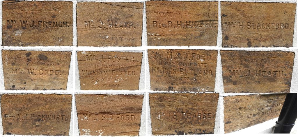
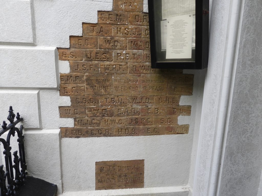
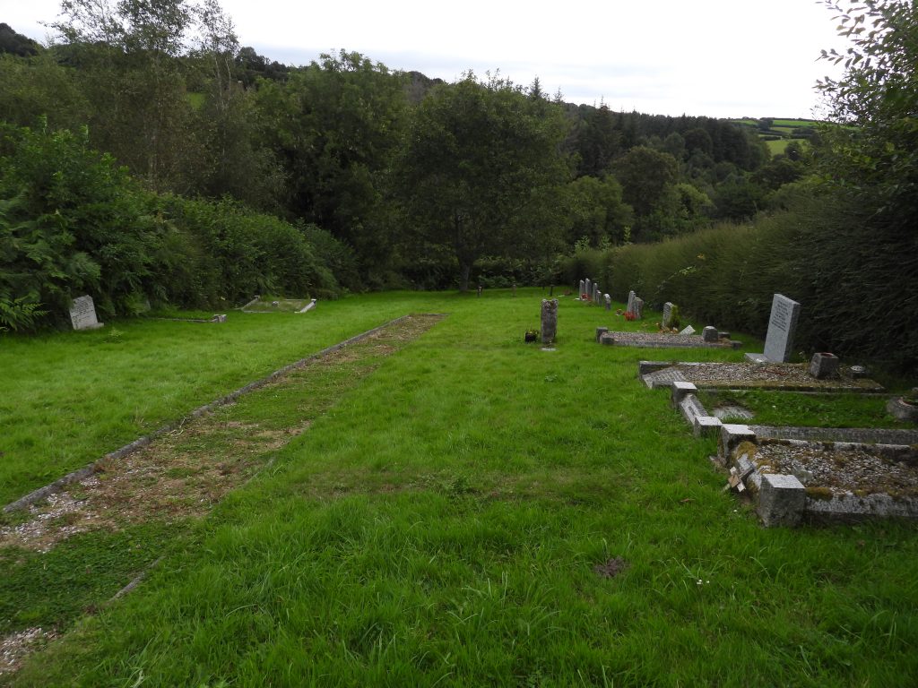
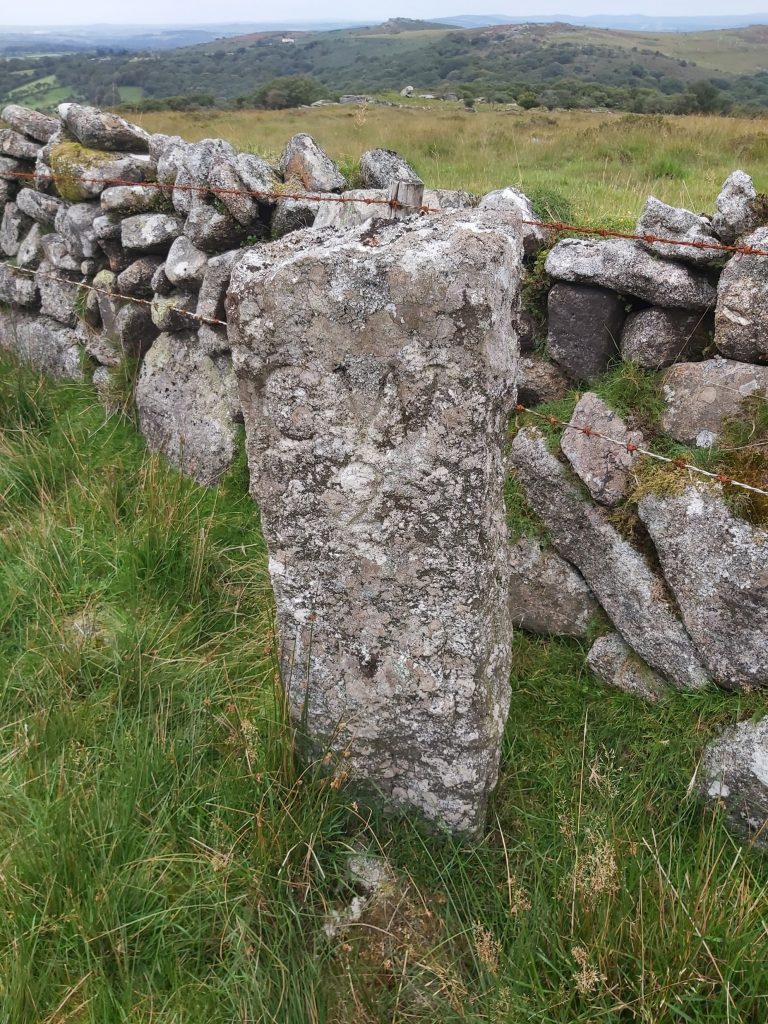
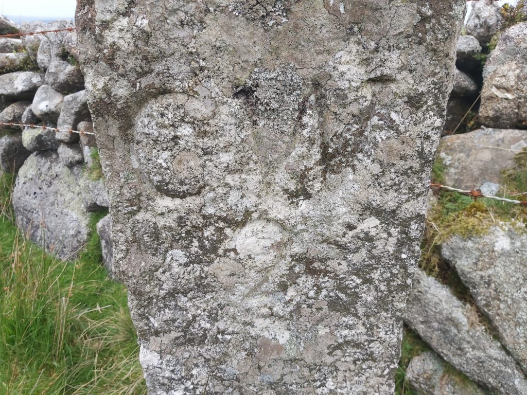
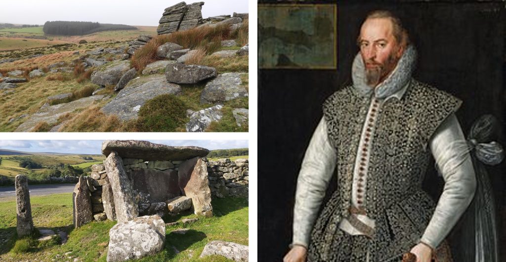
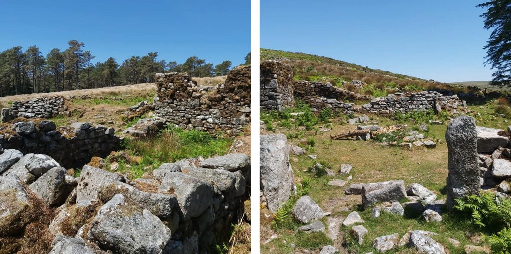
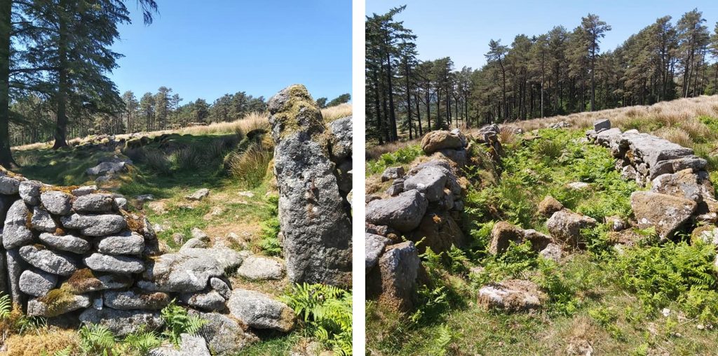
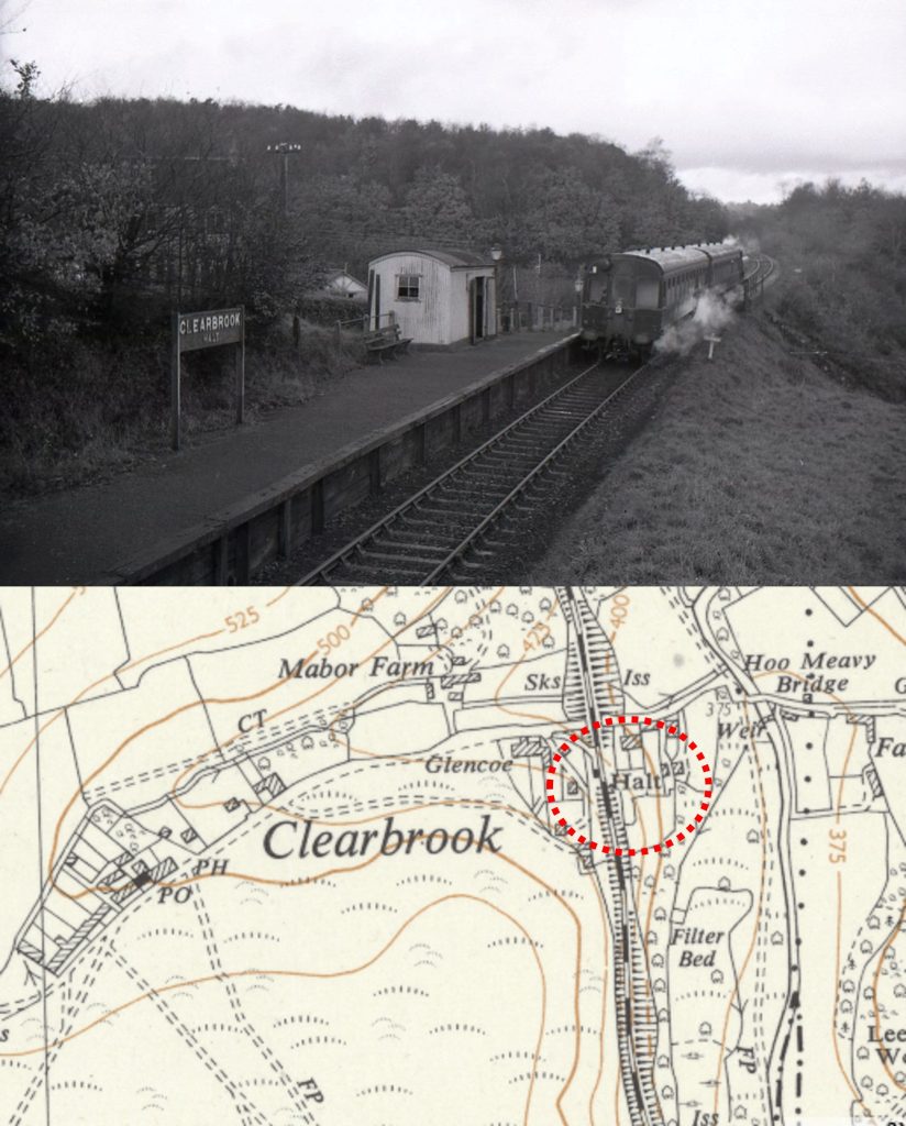
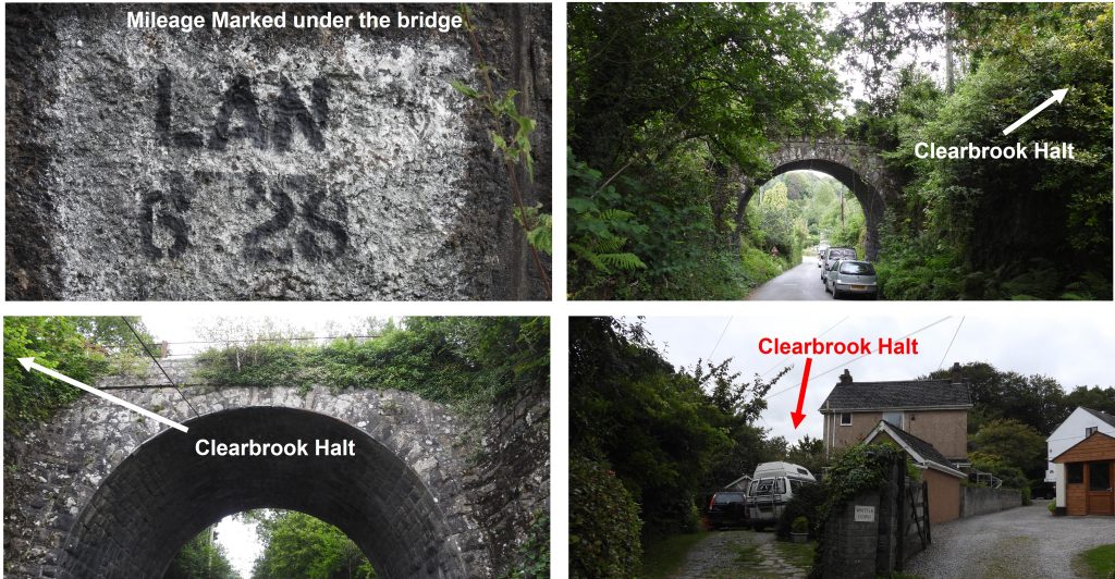
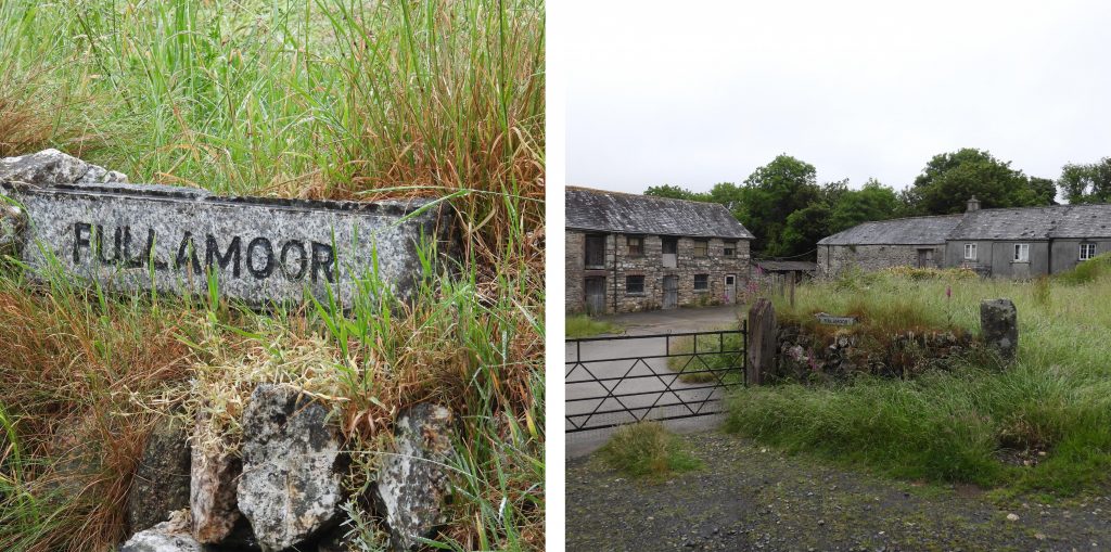
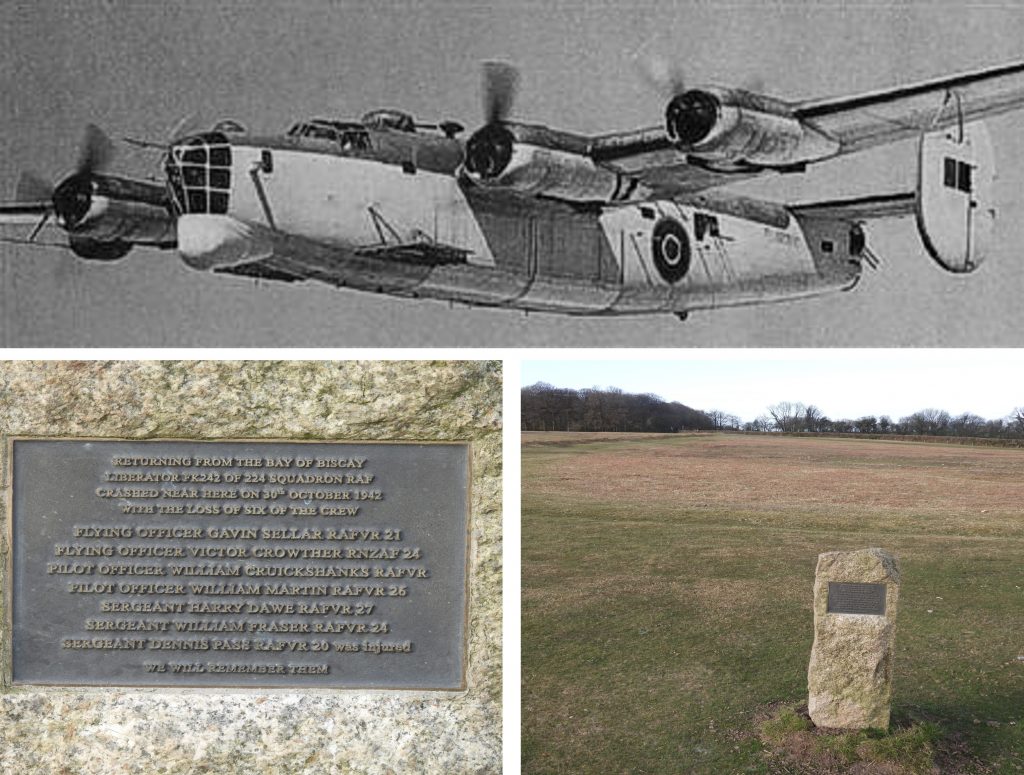
1st October 1930: A meeting was organised by the Dartmoor Preservation Society to consider steps to be taken to protest against the proposed afforestation of Dartmoor in the central area around Bellever and Laughter Hole. Source: The Dartmoor Diary 1991 by DNP. The picture was taken from atop Bellever Tor looking towards Laughter (Lough) Tor and was taken in February 2019.1st October 1930: A meeting was organised by the Dartmoor Preservation Society to consider steps to be taken to protest against the proposed afforestation of Dartmoor in the central area around Bellever and Laughter Hole. The meeting was held at the Athenaeum in Plymouth. Of course, history tells us they were unsuccessful in their protests. The picture is of Laughter Hole House taken from Riddon Ridge in early August 2021.2nd October 2004: “How important is China Clay to Dartmoor” was discussed at 7th Dartmoor Society annual public debate. Source: Dartmoor Magazine Issue 77 (Winter 2004). The debate was held at Lee Moor village hall and is reported as being well attended. At the debate, delegates were reminded that the china clay companies had given up their rights to dump waste on Shaugh Moor (areas X, Y and Z). These areas are shown on the map above.2nd October 2004: “How important is China Clay to Dartmoor” was discussed at 7th Dartmoor Society annual public debate. There was a presentation by Chris Cleaves of Imerys who emphasised the 175 year old industry which (at the time of the debate) employed 260 people. The picture shows a view looking East from Cadover Cross and shows where part of “Area X” from the previous map is located, namely the section of land between the road to Trowlesworthy Farm and the river. 2nd October 2004: “How important is China Clay to Dartmoor” was discussed at 7th Dartmoor Society annual public debate. Delegates were given the opportunity to tour the clay works and the village of Lee Moor to appreciate the social and community elements of the industry. The picture shows the Southern end of area Y near the “Hawks Tor Shelter” and “H” standing stone.2nd October 2004: “How important is China Clay to Dartmoor” was discussed at 7th Dartmoor Society annual public debate. The chairman concluded: “It is clear by the end of the day that people believed the industry to be important for a number of different reasons – as part of the national economy; as a supporter of the local community; and as an environmentally aware and technologically innovative industry working with others to create new landscapes which were already producing ecological benefits”. This view is close to where the former “Emmets Post” and on the boundary of the workings and area Z.2nd October 2004: “How important is China Clay to Dartmoor” was discussed at 7th Dartmoor Society annual public debate. A detailed summary of the debate was published in the October Newsletter of The Dartmoor Society. The picture shows some of the current china clay operations near Cadover Bridge.2nd October 2015: Okehampton Artillery Range: Observation Post 7 was first registered on the Historic England database (list entry 1425410). The database summarises OP as “a stone- and earth- covered concrete splinter-proof shelter, also known as a bunkhouse, built up on a small granite outcrop near to west of the East Okement River and 110m west of the military ring road”.3rd October 1944: Bert Pengelly of Doe Tor Farm was charged £3 10s for 2 hours of threshing by Farm Operations Ltd of Tavistock. Source: Historic Site Appraisal and Survey by Wessex Archaeology – January 2007. The picture of the Farm, Barn (silhouette) and Shippon dates from 1969. The buildings were demolished in 1970.3rd October 1944: Bert Pengelly of Doe Tor Farm was charged £3 10s for 2 hours of threshing by Farm Operations Ltd of Tavistock. The outline from the 1969 picture added to a modern picture from September 2020. Bert Pengelly (son of James and Rosanna) appears to have lived at the farm from 1930 to 1945. He was born in 1908.3rd October 1944: Bert Pengelly of Doe Tor Farm was charged £3 10s for 2 hours of threshing by Farm Operations Ltd of Tavistock. The picture shows the location of Doe Tor Farm, which is easily accessed from High Down Ford or alternatively up the track from Wheal Mary Emma. It is recorded that the farm was established around the 1730s.3rd October 1944: Bert Pengelly of Doe Tor Farm was charged £3 10s for 2 hours of threshing by Farm Operations Ltd of Tavistock. Using the OS Map farm outline and looking at the Wessex Archaeology plan, the infrastructure of the farm becomes apparent. This plan also shows 10 digit NGR references of each part of the farm. The farmhouse was last occupied in 1955.4th October 1868: Reported on this date in The Weekly Dispatch was a Highway Robbery near Rushford Bridge, Chagford. Source: Legendary Dartmoor website in Highwaymen of Dartmoor section. The report from the paper read “Highway Robbery – Miss Hammon, a young lady visiting at Chagford rectory, Devon, was stopped near Rushford Bridge, near Chagford, about six o’clock on Friday evening, by three men, who, after threatening her with personal violence, demanded her watch and money“. The date of the attempted robbery would have been Friday 2nd October 1868.4th October 1868: Reported on this date in The Weekly Dispatch was a Highway Robbery near Rushford Bridge, Chagford. The report from the paper continued: “She, with great coolness, refused to comply with the demand; at this time, very fortunately, approaching footsteps were heard, and the men decamped”. 5th October 2013: The Dartmoor Society held a debate at the Jubilee Hall, Chagford titled : What Future for Ponies on Dartmoor? The pony pictures are: Top Left at Plymouth Leat, Bottom Left at Cator Common, Top Right at Bellever, Bottom Right at River Swincombe.5th October 2013: The Dartmoor Society held a debate at the Jubilee Hall, Chagford titled : What Future for Ponies on Dartmoor? Robyn Petrie-Ritchie spoke on the History & Ecology of Ponieson Dartmoor and mentioned that there are historical records of unbroken ponies at Cornwood in 1086. The picture is Cornwood Square on a rather damp February morning.5th October 2013: The Dartmoor Society held a debate at the Jubilee Hall, Chagford titled : What Future for Ponies on Dartmoor? Robyn Petrie-Ritchie spoke on the History & Ecology of Ponieson Dartmoor and also mentioned there is evidence for ponies on Shaugh Moor in about 1600 BC (their hoofprints were found in an excavated ditch). The pictures are of Shaden Moor Cross and a LM (Lee Moor) / SM (Shaugh Moor) 1835 standing stone next to the old Cadover Bridge to Cornwood road.6th October 2000: On this date a round cairn described as being 740m WSW of Crazy Well Pool was first registered on the Historic England database. Location of the cairn.6th October 2000: On this date a round cairn described as being 740m WSW of Crazy Well Pool was first registered on the Historic England database. In reality the cairn is near the top of Raddick Lane in a clearing of the forest. The registration number on the database is 1009085. 6th October 2000: On this date a round cairn described as being 740m WSW of Crazy Well Pool was first registered on the Historic England database. The database describes the cairn thus : “The cairn mound measures 10m in diameter, stands up to 1m high and is situated within a post-medieval field. A slight hollow in the centre of the mound suggests partial early excavation or robbing”.7th October 1962: Abbots Way annual fundraising walk was started by Bill Ames. It is held on the first Sunday of October and the course is from Buckfast Abbey to Tavistock. The walk is approx 23 miles long.7th October 1962: Abbots Way annual fundraising walk was started by Bill Ames. He had been a headmaster of an international school in Rhodesia and then Ghana before returning to Devon in 1962 to take up the position of Tavistock and District youth officer. Source: Okehampton Times. 7th October 1962: Abbots Way annual fundraising walk was started by Bill Ames. He was passionate about outdoor activities as a way of engaging young people and I believe he started Whitchurch Pin Points, North/South and Abbots Way at about this time. One of the way points is Huntingdon Cross which was originally erected as a waymarker for the Abbots’ Way. However, in the mid 16th Century it was utilised by Sir William Petre, as one of four crosses used to mark the boundary of his manor, Brent, with the parishes of Dean Prior, Harford, and Princetown. Source: Okehampton Times and Dartmoor crosses.org.uk7th October 1962: Abbots Way annual fundraising walk was started by Bill Ames. After Bill, David Ashley, then Tony Bishop became Tavistock youth officers and continued to organise the Abbots Way Walk. In those days the event started at Buckfast Abbey and finished initially at the youth centre in Chapel Street, Tavistock, and then in the 1980s it moved to Tavistock College. Source: Okehampton Times. After Huntingdon Cross the route follows the Avon upstream to the clapper before the steep climb up to Crossway.7th October 1962: Abbots Way annual fundraising walk was started by Bill Ames. After Tony Bishop, the role was taken on by Jimmy James, then Angela Ball, John Collacott and John Olver as the organisers with the administration being carried out by the youth office under Pam Thurgood. Source: Okehampton Times. The picture is of Red Lake Cottage near Crossway another way point and can be found at SX64720 65941. It was the home of captain and Mrs Bray, who managed the operations at Red Lake Clay works. It is recorded that the cottage is 7 miles and 50 chain from the railway shed at Cantrell.7th October 1962: Abbots Way annual fundraising walk was started by Bill Ames. Funds raised from the walk have always been used for youth activities in the Tavistock area. A prominent rock near Erme Head is passed on the walk. BB Broad Rock (BB = Blachford Bounds).7th October 1962: Abbots Way annual fundraising walk was started by Bill Ames. A prominent way point on the walk is at Nuns Cross (or Siwards Cross) before the manned check point near Peat Cot. This cross is probably one of the best known crosses on the moor. The ancient name of Siward’s Cross (Latin: Crucem Sywardii) was quoted in the 1240 perambulation of the Forest of Dartmoor documents.7th October 1962: Abbots Way annual fundraising walk was started by Bill Ames. Another well known cross on the route is Beckamoor Cross (aka Windy Post or Feather Tor Cross). William Crossing puts its age down to the 16th Century and suggests that it may be a replacement for a much older cross that once stood on this site. The cross has a benchmark engraved on it and stands next to the Grimstone and Sortridge Leat which runs from the River Walkham below Great Mis Tor down almost into Horrabridge.7th October 1962: Abbots Way annual fundraising walk was started by Bill Ames. Nearing the end of the walk, Pixie’s Cross is passed (or at least not far from it). It is located on the golf course on Whitchurch Down. Just a couple of miles to go when this point is reached.7th October 1962: Abbots Way annual fundraising walk was started by Bill Ames. The author has completed the Abbots Way walk on 6 occasions (up to the time of this post), the first being on the 28th anniversary of the walk as the certificate testifies. Ordinarily the walk takes around 7-8 hours.8th October 1815: Two bullocks were killed when they fell down a shaft at Whiteworks Tin Mine. Source: Dartmoor Diary 1991 by DNP. The plan of the mine above shows that at least two of the shafts have been walled for stock protection.8th October 1815: Two bullocks were killed when they fell down a shaft at Whiteworks Tin Mine. The picture shows one of dozens of shafts around the mine. This one is at SX61237 70920. 8th October 1815: Two bullocks were killed when they fell down a shaft at Whiteworks Tin Mine. This walled shaft for stock protection can be found at SX61344 70835.9th October 1986: A public meeting at Postbridge Village Hall was held on this date to discuss low flying aircraft on Dartmoor. The picture was taken just south of Kings Tor. The aircraft looks like its destined to crash into the spoil tip at Swell Tor quarries.9th October 1986: A public meeting at Postbridge Village Hall was held on this date to discuss low flying aircraft on Dartmoor. In attendance was a Ministry of Defence Secretariat Civil Servant. Source: DNP Dartmoor Diary 1991.10th October 1239: The Forest of Dartmoor and Manor of Lydford was granted by Henry III to his brother Richard, Earl of Poitou and Cornwall. Source: DNP Dartmoor Diary 1991. Richard had rebelled against the King on three occasions and he had been “bought off” with lavish gifts. In 1238, Richard had rebelled against Simon of Montfort (one of Henry’s favourites). He was once again placated in 1239 so King Henry gave him the Forest of Dartmoor. Interestingly, after Richard was “gifted” Dartmoor should have really been called a “Chase” as only a King can own a Forest.10th October 1239: The Forest of Dartmoor and Manor of Lydford was granted by Henry III to his brother Richard, Earl of Poitou and Cornwall. It wasn’t until 1240, that the bounds of the Forest of Dartmoor were perambulated upon the King’s order to ratify who owned what and to settle disputes between Richard (the now owner) and four knights with neighbouring lands. Today, the Forest Boundary accepted by the Duchy includes Cosdon (Top Left), The Longstone (Top Right), Limsboro’ Cairn (Bottom Left) and Eastern Whitebarrow (Bottom Right).11th October 1988: Claude Warren of Buckfastleigh, aged 82 passed away on this date. He was well known in the district and had a great knowledge of the moor. He came from a family of blacksmiths at Holne and his very first job was to hammer the little iron balls on the spikes of the railings surrounding Venford Reservoir. The picture shows some of the railings next to the PUDC / RDH stone at the West end of the dam.11th October 1988: Claude Warren of Buckfastleigh, aged 82 passed away on this date. The iron balls were added to the railings following a hunting incident. A fox was being pursued by the hounds and went through the railings. The hounds were unable to follow and some were subsequently unfortunately impaled. 11th October 1988: Claude Warren of Buckfastleigh, aged 82 passed away on this date. The task of adding all the iron balls must have been a mammoth task and they certainly have withstood the testaments of time. A lovely tribute to Claude was recorded in the Dartmoor Magazine, Issue 14 (Spring 1989) which describes when he took a blind man for a walk on Dartmoor, recording on tape a running commentary on the sights and sounds around them. This was used as a library for the blind.12th October 1878: The Lydford Junction to Okehampton railway line opened. Lydford was originally built as the terminus of the Plymouth Devonport & Junction Railway. In 1865, Lydford later became a junction when the Launceston and South Devon Railway completed its extension from Tavistock to Launceston. The station was opened on 1st June 1865. 12th October 1878: The Lydford Junction to Okehampton railway line opened. The line was was a 4 ft 8 1⁄2 in (1,435 mm) standard gauge line that carried trains direct from London Waterloo station. On the line is Lake viaduct which extends for 140 yards, comprising nine arches – each 40 feet in span – and reaches a height of 70 feet. It is built entirely in granite.12th October 1878: The Lydford Junction to Okehampton railway line opened. Meldon viaduct on the line spans the West Okement and is a scheduled monument. The viaduct spans a distance of 166m (541 ft) and is 46m (150 ft) high.12th October 1878: The Lydford Junction to Okehampton railway line opened. Underneath Meldon viaduct you can clearly see the doubling of the width alongside the original single track bridge. 12th October 1878: The Lydford Junction to Okehampton railway line opened. The line passes Meldon Quarry. The station was originally constructed circa 1920 as Meldon Quarry Halt by the L&SW Railway and at such time had no public access and merely functioned as a staff halt for quarry workers, their families and other railway staff working at Meldon Quarry. The quarry originally had no metalled road access and some quarry workers and their families lived in cottages situated near the quarry. They used the halt for access to Okehampton. The halt was not shown in the public railway timetable and local passenger services would only call by special arrangement.13th October 1945: An American Douglas C-47 Skytrain 42-100640 struck the hillside at Huntingdon Warren. It was flying from Erding, Germany to Exeter but was diverted to Westernzoyland. The flight was just after WWII hostilities had ended. Source: Dartmoor Air Crashes by Robert Jones.13th October 1945: An American Douglas C-47 Skytrain 42-100640 struck the hillside at Huntingdon Warren. The aircraft was part of 484th Air Support Group USAAF. This was the last air crash reviewed around WWII. There had been around 45 air crashes around the moor between 1939 and 1945. 13th October 1945: An American Douglas C-47 Skytrain 42-100640 struck the hillside at Huntingdon Warren. Sadly all 7 crew were killed. The number of crashes that took place over Dartmoor during this period is a tangible reminder of the extent the air war that took place over the UK during WWII.14th October 1966: R.G.Haynes visited the small rectangular structure called “The Smithy” on the 1866 map, within Trowlesworthy Warren. His visit was recorded in Ruined Sites on Dartmoor, 139-40 (Un-published). Source: Dartmoor HER. The building can be found at SX57338 64550. The picture shows Little Trowlesworthy on the horizon.14th October 1966: R.G.Haynes visited the small rectangular structure called “The Smithy” on the 1866 map, within Trowlesworthy Warren. The Smithy can be best viewed looking from above in a South Westerly direction. The stone to construct this building may have been taken from nearby abandoned stone hut circles and enclosure walling.14th October 1966: R.G.Haynes visited the small rectangular structure called “The Smithy” on the 1866 map, within Trowlesworthy Warren. “The Smithy” is described in the Dartmoor HER as : “a two compartment structure which may have been the smithy and dormitory for workers at Little Trowlesworthy quarry until the 1880s”. The quarry was worked by John Freeman Sons and Co. of Penryn until the 1880’s. “The Smithy” was demolished by a local farmer to build his shippen.14th October 1966: R.G.Haynes visited the small rectangular structure called “The Smithy” on the 1866 map, within Trowlesworthy Warren. The Dartmoor HER further describes “The Smithy” thus: “The interior of the northern room (room 2) measures 4.5m long by 2.5m wide, whilst the southern one (room 1) is 4.5m long by 3m wide. The partition wall separating the two rooms measures 0.45m wide and stands up to 0.9m high, whilst the exterior wall survives as a 1.5m wide and 0.6m high rubble bank”.14th October 1966: R.G.Haynes visited the small rectangular structure called “The Smithy” on the 1866 map, within Trowlesworthy Warren. A cache is nearby to “The Smithy” and is attached to the outer face of a prehistoric enclosure.14th October 1966: R.G.Haynes visited the small rectangular structure called “The Smithy” on the 1866 map, within Trowlesworthy Warren. The author found the cache quite difficult to discern but (hopefully) successfully located it at SX57345 64541. The cache is described as “surviving as a 1.3m wide and 1m high rubble wall surrounding a rectangular internal area which measures 1.9m long by 1m wide”. The rocks in the picture appear to fit the description and is the closest point to the pound from “The Smithy”.14th October 1966: R.G.Haynes visited the small rectangular structure called “The Smithy” on the 1866 map, within Trowlesworthy Warren. The cache structure was probably built for storage of tools and equipment.15th October 2004: Peter Hirst, a member of the Dartmoor Tin Research Group (DTRG) committee sadly passed away on this date. In 1996, he co-authored with Roger Bird, The Brimpts Tin Mines – Dartmeet which was published by the DTRG. The picture is of a leaflet issued by the DTRG around that time, which the author bought for the princely sum of 30p !15th October 2004: Peter Hirst, a member of the Dartmoor Tin Research Group (DTRG) committee sadly passed away on this date. The Brimpts Mine trails were established on the initiative of Peter Hirst. The pictures are from the South Mine near the farmhouse. The main mining activities were between 1787-1798 and 1849-1855. Source: DTRG leaflet.15th October 2004: Peter Hirst, a member of the Dartmoor Tin Research Group (DTRG) committee sadly passed away on this date. The Brimpts Tin Mines Trail has had (at least) two further leaflet iterations as can be seen in the photographs. Aside his work with DTRG, Peter Hirst also was the Chairman of the Widecombe Fair Committee and he was an active participant of the Widecombe History Society. Peter had moved to Badgers Holt Bungalow, Dartmeet from Harlow in 1990. Source: Dartmoor Magazine, Issue 77, Winter 2004.15th October 2004: Peter Hirst, a member of the Dartmoor Tin Research Group (DTRG) committee sadly passed away on this date. The pictures are from the North Mine on the Brimpts Farm Mine Trail, which is located near Laughter (Lough) Tor. The pictures show some of the shafts (fenced ones) and a horse whim. 16th October 2000: Hentor Warren boundary stone (HWB2) standing on Lee Moor 860m south west of Hen Tor was first registered by Historic England (1015757). The designation states :”boundary stone denoting the eastern edge of Hentor Warren and is situated on a gentle west facing slope on Lee Moor overlooking the valley of Spanish Lake. The stone stands 1.02m high and is 0.24m wide by 0.25m thick”. The picture of the stone was taken late afternoon on a day in September 2015.16th October 2000: Hentor Warren boundary stone (HWB2) standing on Lee Moor 860m south west of Hen Tor was first registered by Historic England (1015757). The designation continues: “The letters HWB2 are incised on the eastern face of the stone indicating that it is the second boundary marker of Hentor Warren. The stone is mentioned in an 1807 lease granted by Lord Boringdon to Peter Nicholls of Sheepstor, a warrener. This monument is in the care of the Secretary of State”. The picture was taken on a late afternoon in March 2019, which shows (dark area) evidence of swaling. 17th October 1582: The Walkhampton Court Roll for this date recorded a fine of 2d. due to an illegal diversion of a leat at Deancombe. Source: DNP Dartmoor Diary 1991. The 1900 OS map shows there were two farms at Deancombe at one time.17th October 1582: The Walkhampton Court Roll for this date recorded a fine of 2d. due to an illegal diversion of a leat at Deancombe. It is recorded in the DNP Dartmoor Diary that: “Robert Cockle had put himself at the mercy of the court because he had diverted the pottwater of John Windiatt being upon the land of Alice Windiatt called Deancombe out of its right course”. The pictures are of the main building, outbuilding and trough at West Deancombe. 17th October 1582: The Walkhampton Court Roll for this date recorded a fine of 2d. due to an illegal diversion of a leat at Deancombe. The court made the order for the payment to “the Lord for the trespass aforesaid”. The pictures are East Deancombe including two granite pillars for a grinding wheel.18th October 2016: A number of PCWW (Plymouth City Water Works) stones were restored by seven Dartmoor Society volunteers. The (three) stones which were restored (as described in Dartmoor Society News) were between Nuns Cross Farm and Eylesbarrow. History: In 1893, the Plymouth Corporation Water Act was approved, which effectively gave them the right to “impound the water of the River Meavy and its tributaries”. Subsequently the reservoir at Burrator was constructed and was completed in 1898 effectively replacing Drake’s Leat (the previous source of water dated from 1591), which had become inadequate. The reservoir watershed, however, was owned by others, in the main Sir Henry Lopes of Maristow. The area of the watershed was 5300 acres. The selling of the watershed lands to the Plymouth City Water Works in 1916, 1919 and 1932 led to the erection of the granite boundary markers.18th October 2016: A number of PCWW (Plymouth City Water Works) stones were restored by seven Dartmoor Society volunteers. The volunteers were Tom and Elisabeth Greeves, Barrie Quilliam, Tanya and Barry Welch. There are 71 granite boundary posts as follows: PCWW 1917 (57) , PCWW 1919 (10) and PCWW 1932 (3) plus one post which is not inscribed and one inscription on North Hessary Tor (total 72). These are labelled PCWW 1-72. The sketch map in the previous picture has been faithful to the nomenclature of the “Old Plymouth Society”. It is possible that the restoration may have included PCWW (1917) #40 or #41 (or even both).18th October 2016: A number of PCWW (Plymouth City Water Works) stones were restored by seven Dartmoor Society volunteers. It is possible that the restoration may have included PCWW (1917) #42 or #43 (or even both). On the day, due to the excessive rain after reaching the third and final stone to be repaired, both a tractor and trailer got wedged in soft ground and proved to be totally stuck. As well as the granite markers (1917, 1919 and 1932) there is a series of smaller cast iron marker posts in the vicinity of the reservoir, which are undated and whose purpose is unclear.19th October 1973: Ian Mercer took up the appointment of Dartmoor’s first National Park Officer. The pictures are left: Ian Mercer at his desk at National Park Office; top right: Ian Mercer on Ter Hill; bottom right: the authors picture of Ter Hill (Mount Misery Cross) on a considerably more murky Dartmoor day than when Ian Mercer was there. He was the National Park Officer until 1990 and it is said that his greatest triumph was the Dartmoor Commons Act 1985. This was private legislation which set up a governing commoners’ council while giving the public the right to walk and ride the commons. 19th October 1973: Ian Mercer took up the appointment of Dartmoor’s first National Park Officer. The picture is of a “relatively new” set boundstone, dating from 1990. It is located at SX67820 68647. It was ‘unveiled’ at the Holne 1990 beating of the bounds, when Ian Mercer, the then Dartmoor Park Officer and acting steward of Holne Manor on behalf of Devon County was asked to remove a covering of bracken to reveal it.19th October 1973: Ian Mercer took up the appointment of Dartmoor’s first National Park Officer. The stone is inscribed with the obligatory ‘H’ for Holne but also (in sans-serif apparently) the initial I M (Ian Mercer). The stone was a token of appreciation by the Commoners for Ian Mercer for all he had done for the moorland farming community and Dartmoor in general. He was, apparently, ceremoniously ‘bumped’ on the stone, being lifted by several of those assembled.20th October 1986: On this date, work began on the undergrounding of overhead telephone wires on Lynch Common. The pictures are from the road on the north side of Lynch Common between Ringmoor Cottage and the Cadover Bridge / Meavy road.20th October 1986: On this date, work began on the undergrounding of overhead telephone wires on Lynch Common. The project was financed jointly by British Telecom and the National Park Authority. There are some fabulous views to the north from the common and include Meavy village, Burrator dam and Sheepstor.21st October 1638: During an afternoon service held at St. Pancras Church, Widecombe-in-the-Moor, a violent thunderstorm led to lightning striking the tower. This led to fireball passing through the church killing four worshippers. As well as four worshippers sadly being killed another 62 were injured. Source: DNP Dartmoor Diary 1991. The picture was taken on the day of Widecombe Fair in September 2019.21st October 1638: During an afternoon service held at St. Pancras Church, Widecombe-in-the-Moor, a violent thunderstorm led to lightning striking the tower. The tower clock is a gift from Mrs M. Harris, its face on the west side. It was a memorial to her husband, Mr S. Harris; they both had been interested in church towers and had promised each other whoever should die first, the other would put a clock in the tower in his or her memory. The date chosen was 21st October 1979, to coincide with the 341st anniversary of the tragedy. Source: Dartmoor Magazine No. 16, Autumn 1989. 21st October 1638: During an afternoon service held at St. Pancras Church, Widecombe-in-the-Moor, a violent thunderstorm led to lightning striking the tower. The picture of the grave (the cross in the lower right corner) is that of Olive Katherine Parr, otherwise known as Beatrice Chase. There is a lovely model of the church inside and some magnificent wood carvings.22nd October 1991: On this date, Spurrell’s Cross was registered as a scheduled monument by Historic England. The registration number is 1012238. The cross is also known as Purl’s, Spurls, Purles, or Pearl’s. It stands on the Blackwood Path close to the intersection of the Owley-Harford track and the Wrangaton-Erme Plains track.22nd October 1991: On this date, Spurrell’s Cross was registered as a scheduled monument by Historic England. It is thought that the name Spurrell’s relates to the Spurwell family from nearby Harford, of which the last member to live was Thomas, who died in 1634. Source: High Dartmoor by Eric Hemery (page 257). The Historic England description of the cross is as follows: “It is a granite cross 1.37m high, with a restored shaft and head of a different granite with spurred limbs. The head is set north/south and the northern arm is missing. 23rd October 1938: Duck’s Pool Letterbox was declared open. With the permission of the Duchy of Cornwall, it was erected as a commemoration to William Crossing. The bronze plaque reads: “In memory of William Crossing; author of many inspiring books on Dartmoor, whose guide is a source of invaluable information to all lovers of the moor. Died 3rd Sep 1928”.23rd October 1938: Duck’s Pool Letterbox was declared open. The memorial to William Crossing was set up by Dobson’s Moormen, a group of walkers who were once known as the Ford Wesleyan Recreation Club. Dr J W Malim and H. Franks were part of Dobson’s Moormen, who placed the letterbox canister with stamp and tablet as well setting up the memorial plaque. The first box was a teak container. However, in 1963 a new zinc container was placed at the Duck’s Pool and had an engraved tablet on its lid as a memorial to Mr R. C. Carter, a founder of the Dobson’s Moormen. 24th October 1937: On this day, the author of “Days on Dartmoor Diary 1939-1945”, Kenneth F Day completed a walk from Powder Mills to Okehampton, where he caught a train back to London. The first part of his walk was described thus: “We left Powder Mills at 9.45 a.m. We took the high road over Higher Cherrybrook Bridge, down into Postbridge which we reached at 10.15 a.m. Turning in at the gates of Stannon, we ascended Stannon Tor (1517′) and passed over the western slope of White Ridge to the double stone circle of Grey Wethers arriving there at 11.30 a.m”. 24th October 1937: On this day, the author of “Days on Dartmoor Diary 1939-1945”, Kenneth F Day completed a walk from Powder Mills to Okehampton, where he caught a train back to London. The next part of his walk was described thus: “Flanking Sittaford Tor (1764′) we crossed the North Teign River just above Teignhead Farm, climbed Great Varracombe and crossing a small stream, attained Whitehorse Hill (1974′) at 12.50 p.m. from which height all the salient features of our previous days walk could be seen. The going hitherto had been rough but firm; but the ridge northward to Hangingstone Hill (1984′), proved very seamed, though not so boggy as in the vicinity of Cut Hill and Cranmere. We reached Hangingstone at 1.20 p.m. and at this time the rain that had been threatening from the west held off no longer”.24th October 1937: On this day, the author of “Days on Dartmoor Diary 1939-1945”, Kenneth F Day completed a walk from Powder Mills to Okehampton, where he caught a train back to London. The final part of his walk was described thus: “We dropped down the northern slope (of Hangingstone Hill) to the commencement of the military track, which we followed over Okement Hill (1857′), under East Mill Tor (1684′) and across the Black-a-Ven at New Bridge, which we passed at 2.40 p.m. Rain now fell steadily, but Yes Tor and High Willhays presented a fine appearance, their summits occasionally hidden by driving cloud. We dropped down into Okehampton at 3.45 p.m. in good timeto catch our train which left at 4.11 p.m. We reached Waterloo at 9.15 p.m.” The author has assumed Kenneth F. Day would have passed Fitz’s Well en-route to Okehampton Station. 25th October 1904: Scoriton Chapel opening ceremony took place on this day. The building on the north west side of the village on the Michelcombe / Holne road is in actual fact two buildings, which were built in 1834 and 1904. The original chapel (which became the Sunday School) is nearest the camera in the above picture with the “new” chapel, which is the subject of this post, is at the far end. They are separated by a lobby entrance. The entrance door of the original chapel is at the south east end of the building and faces the camera in the photograph.25th October 1904: Scoriton Chapel opening ceremony took place on this day. The original (Wesleyan) chapel cost £90 to construct in 1834 and new 1904 chapel around £450. The new chapel was built due to the increasing popularity of Scoriton Chapel alongside the decreasing popularity of Holne Church, where Rev’d Gill ‘ruled with a rod of iron’ and was a very difficult man. The opening ceremony was preceded by a luncheon. There were enthusiastic speeches made at the ceremony and it was hoped that the final £40 for the chapel could be raised Source: Dartmoor Magazine, Issue 76, Autumn 2004. 25th October 1904: Scoriton Chapel opening ceremony took place on this day. Viewing from the graveyard, the stark differecne between the 1834 and 1904 constructions becomes evident. The kitchen extension looks a 20th century addition.25th October 1904: Scoriton Chapel opening ceremony took place on this day. The pictures show the 1834 entrance taken from the Tradesman Arms car park (top left), lobby entrance between the two buildings (bottom left and bottom right) and OS benchmark which is on north east end of the 1904 chapel (bottom right).25th October 1904: Scoriton Chapel opening ceremony took place on this day. The new chapel foundations were completed by end of June 1904. The contractor was a Mr Badcock (of Ashburton) with the supervision being carried out by a Mr Edwards (also of Ashburton) and the stone being supplied by John Butland’s quarry in Michelcombe. The stone was brought to site by a Mr William French using farm carts. There are 14 inscribed foundation stones with 13 facing the road. The end (north west) stone being dated 1904 with the name Mrs James Hamlyn. Source: Dartmoor Magazine, Issue 76, Autumn 2004. 25th October 1904: Scoriton Chapel opening ceremony took place on this day. The collage of photographs above show 12 (of the 13) foundation stones facing the road. The 13th stone is Mrs James Hamlyn (see previous photograph). The foundation stones were laid by August Bank Holiday 1904. Of note of the names inscribed: Top Row far left – Mr W. French assisted with bringing stone to the site and contributed £10 15s, Top Row far right – Mrs H. Blackford, whose husband contributed £14, Middle Row far left – Mrs W. Codd, whose husband contributed £7 4s, Bottom Row second from right – Mr J. B. Pearse contributed £44 13s 6d. The last stone (Bottom Row far right) behind the drain pipe is inscribed Mrs J.T.Bond who was the wife of Alderman Bond of Plymouth laid the “chief” stone at a ceremony on the August Bank Holiday 1904. All the above information was obtained from the Dartmoor Magazine article.25th October 1904: Scoriton Chapel opening ceremony took place on this day. The 14th foundation stone (Mr J.S.Doidge) is located in the lobby entrance between the 1834 and 1904 buildings.25th October 1904: Scoriton Chapel opening ceremony took place on this day. The photograph is the graveyard behind the 1834 building.26th October 1835: A letter written to a Mr Dickins by the manor steward on this date, provided details of the locations of seven stones marking out a large sett for the Walkhampton China Clay Works. At the foot of the enclosure wall a short distance west of Little King Tor stands a boundstone inscribed ‘CW2’, the only known survivor of an original seven stones. This stone can be located at SX55152 73883.26th October 1835: A letter written to a Mr Dickins by the manor steward on this date, provided details of the locations of seven stones marking out a large sett for the Walkhampton China Clay Works.
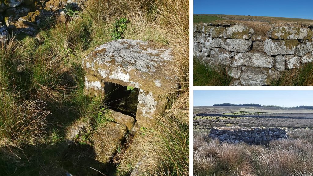
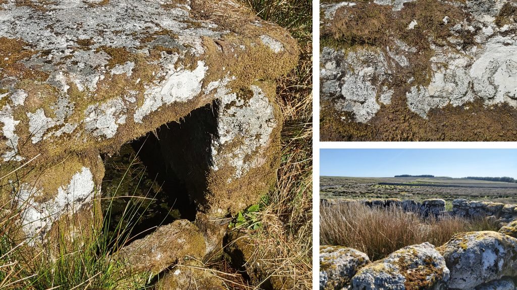
The letter states: “In order to shew the Boundaries of Mr Barons Clay Set, you will recollect seven granite posts will be required to be set up with inscriptions thereon as under. Will you be good enough to get some person to prepare them — each as near the place where wanted, as conveniently may be. They should be set up before the Lease is executed. No 1, By the Rail Road near Prince Town to be inscribed W on the West side D on the East; No 2, By the side of the High Road — similarly inscribed; No 3, Corner of the Hedge of the Field called Furze Park part of Waytown to be inscribed on the North side thereof CW1; No 4, By the Hedge on the West side of little King Torr to be inscribed on the South side thereof CW2; No 5, To be sett up to shew the Triangular piece on the North side; No 6, of the Rail Road to be severally inscribed on that side which; No 7, will be towards the Land granted CW3, CW4, CW5. No working will be required, unless it be a little facing, at the place of inscription — nor need they be above two or three feet above ground — they should however let into the ground 18 inches or two feet”. Source: Mike Brown Guide to Dartmoor CD27th October 1971: Fice’s Well was first registered on Historic England database. The registration number is 1002616. The database entry states: “This monument includes a holy well situated within the Black Brook Valley close to the river. The monument survives as a circular walled enclosure with a flight of access steps and contains a roofed, square stone built well building. The enclosure measures approximately 6.5m in diameter and is defined by a faced outer stone wall of up to 1.5m high with an earth ramp on the interior topped with a stone parapet. On the south east side are a series of nine stone steps which provide access. The well building is constructed from drystone walling and measures approximately 0.8m by 0.8m internally and is 0.8m high”.27th October 1971: Fice’s Well was first registered on Historic England database. The database further states: “Externally the side walls are approximately 1m high and composed of two courses supporting a square capstone which measures 1.1m long and wide and up to 0.2m thick. On the front edge of this capstone are two recessed panels containing the inscriptions ‘I F’ and ‘1568’ which stands for John Fice, identified by Revd Bray in the 19th century as being John Fitz of Fitzford, an astrologer, who with his family had a rather strange history. The original circumstances surrounding the construction of the well is unknown, although local legend about it being built by a thirsty traveller seems unlikely given its close proximity to the Black Brook. The well water is also reputed to have eye-healing properties. The area around the well was drained in the 19th century and the outer enclosure was constructed at this time. The well is listed at Grade II”.27th October 1600: Sir Walter Raleigh presided over a Great Stannary Court at Crockern Tor of 96 Devon tinners from Chagford, Ashburton, Plympton and Tavistock. This was the last gathering to be held at Crockern Tor itself although there were a few later ‘great courts’ (ref: passmore – Heritage Gateway). The stone chairs and table of the stannaries are no longer in situ, but the so-called “Judge’s Seat” still exists at Dunnabridge Pound.28th October 1966: R.G. Haynes visited Roundy Farmstead in the parish of Walkhampton. In his records (1966-1969, Ruined Sites on Dartmoor, 111 (Un-published). SDV150434.) he states “Lintel stone bore date 1668. The farmhouse is quite small with very small windows. Fireplace could not be seen though lintel was visible. Possible stairwell with blocked doorway.” Roundypark Farm was first recorded 1668 and was abandoned around 1841. The main building can be found at SX57807 70120.
The English heritage record states: “The farmhouse is terraced into the hillslope and survives as a two roomed rectangular building defined by a 0.7m wide drystone wall standing up to 2.6m high. The upper room measures 5.1m long by 3.9m wide and is separated by a rubble partition wall from the lower room which is 3.9m long and 3.3m wide”. The Haynes observation about the lintel stone is recorded by English Heritage as bearing the letters RC and the date 1668. However, this stone can no longer be seen at the farm as it was subsequently removed to Burrator. It has been suggested also that the initials RC are those of Richard Crymes, whose family were long seated at Crapstone.28th October 1966: R.G. Haynes visited Roundy Farmstead in the parish of Walkhampton. The pictures show the entrance to the farm (left) and a second building (right). The second building was a barn (or shippon). It is defined by drystone walling, standing up to 1.3m high. The interior of this structure measures 7.62m long by 3.05m wide, the doorway faces west and leads directly into the farmyard. (Source: English Heritage). The barn can be located at SX57787 70113. The farmstead was shown as ‘Roundepark’, still roofed, on mid-19th century Tithe Map.29th October 1928: Clearbrook Halt was opened. The description from oldplymouth.uk/ Railways Launceston Branch states “It had taken about three weeks to construct, although the timber-fronted platform was made up with ashes, the painters had not finished their work, and the house containing the waiting room and booking office had not arrived. Judging from the photographs of a typical waiting hut made of corrugated iron, the “house” never did arrive: 29th October 1928: Clearbrook Halt was opened. The halt today cannot be accessed as there is a private property and garden on the site. The halt was built close to the bridge over the Clearbrook / Hoo Meavy road. Under the bridge is a sign which indicated that the bridge is at 6 miles 25 chains mile point from Tavistock Junction. Clearbrook Halt was closed to passenger traffic on December 31st 1962, when the Launceston Branch was closed.30th October 1951: Happy 70th Birthday Dartmoor ! The designation of Dartmoor as a National Park was confirmed on this date. The Peak District, Lake District and Snowdonia were also awarded the designation in 1951.30th October 1991: On this date, the “History as it happens” photographic competition results (to co-incide with the 40th anniversary of Dartmoor National Park) were announced. The winning photograph (above) was by Ann Hain and was called “Rails – River Teign”. The competition was organized and sponsored by the Museum of Dartmoor Life, the Dartmoor Magazine, the Dartmoor National Park and West Devon Borough Council. The winners were announced at a special presentation event held at the Museum of Dartmoor Life. Source: Dartmoor Magazine, number 25 (Winter 1991).30th October 1991: On this date, the “History as it happens” photographic competition results (to co-incide with the 40th anniversary of Dartmoor National Park) were announced. The photographs above of the Manga Rails, (also known as Mangersford) were taken in December 2020, whilst the author was completing the Forest of Dartmoor Perambulation walk.30th October 1942: A Liberator IIIa FK242 of 224 Squadron was returning from an patrol over the Bay of Biscay when it crashed at Fullamoor Farm. It had taken off from RAF Beaulieu, Hampshire and had been employed to escort ships as part of Operation Torch, the Allied invasion of North Africa. After ten hours on patrol the Liberator whilst on its return journey hit a barrage balloon cable as it passed over Plymouth. The aircraft was badly damaged and the crew tried to make an emergency landing at RAF Harrowbeer, Yelverton. It was dark and with no runway lights to guide it, so sadly it crashed at Fullamoor (near Horrabridge). Source: Devonmuseums.net 30th October 1942: A Liberator IIIa FK242 of 224 Squadron was returning from a patrol over the Bay of Biscay when it crashed at Fullamoor Farm. On Plasterdown, close to Fullamoor Farm is a memorial plaque mounted on a granite post commemorating six of the crew who died – a 7th crew member was seriously injured.31st October: This date is also known as All Souls Night, Night of the Dead or Halloween. It is said to be the night when the portal between the worlds of the dead and the living are opened. Amongst the numerous legends relating to Dartmoor is Lydford Castle. The 12th century castle was once used as a prison for offenders against Dartmoor’s strict hunting and tin-working laws. It is said that Judge Jeffreys, notorious for his harshness is said to haunt the castle in the shape of a black boar. That said, although he held court in many Devonshire towns, and legend holds that he was at his savage and judicial best at Lydford, despite a scarcity of historical evidence that he ever visited the village! 31st October: This date is also known as All Souls Night, Night of the Dead or Halloween. The myth and legend of the haunting by Judge Jefferys may relate to the loathing people had for him. Although he held court in many Devonshire towns, and legend holds that he was at his savage and judicial best at Lydford, despite a scarcity of historical evidence that he ever visited the village!