A collection of walks, discoveries, insights and pictures of exploring Dartmoor National Park
October 2, 2021
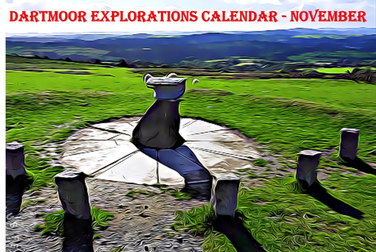
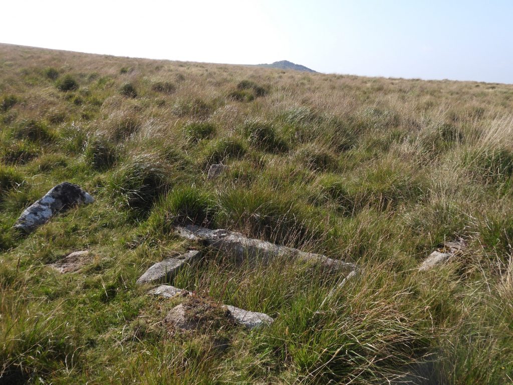
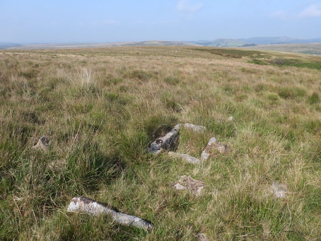
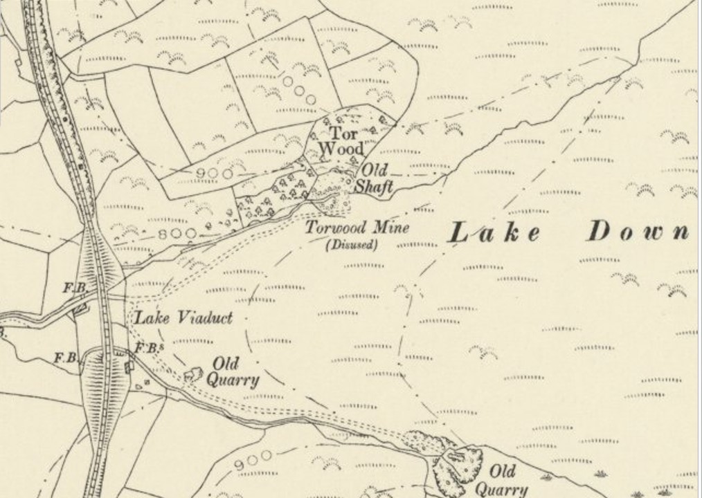
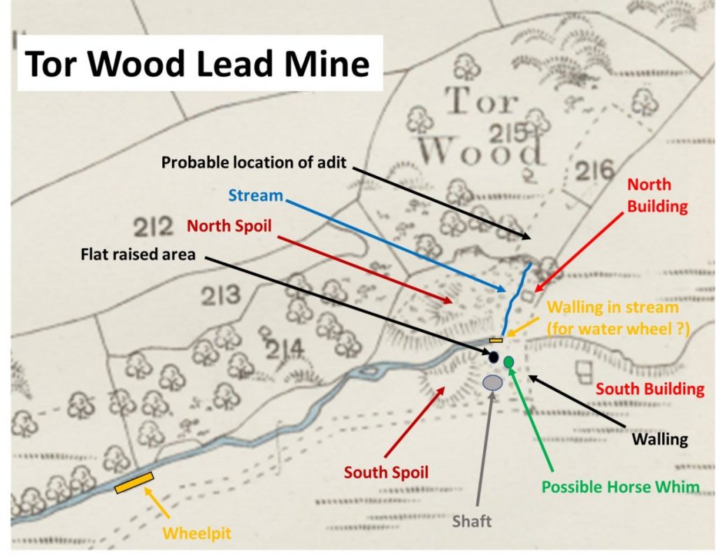
DARTMOOR EXPLORATIONS CALENDAR – November
In 1991, the Dartmoor National Park Authority (DNPA) published a spiral bound diary to commemorate their fortieth anniversary (1951-1991), called “The Dartmoor Diary”.
Inspired by this publication (and some of the entries in it) and to celebrate the DNPA 70th anniversary year in 2021, the “Dartmoor Explorations Calendar” records an event or story, complemented with photographs for each day of the year.
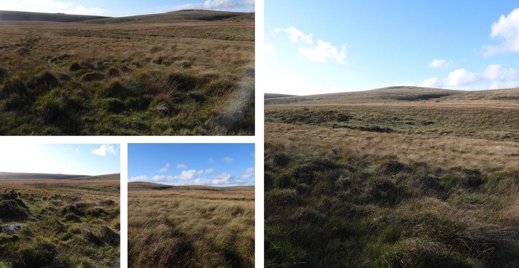
This page of the Dartmoor Explorations Calendar celebrates November on Dartmoor and its immediate borderlands.
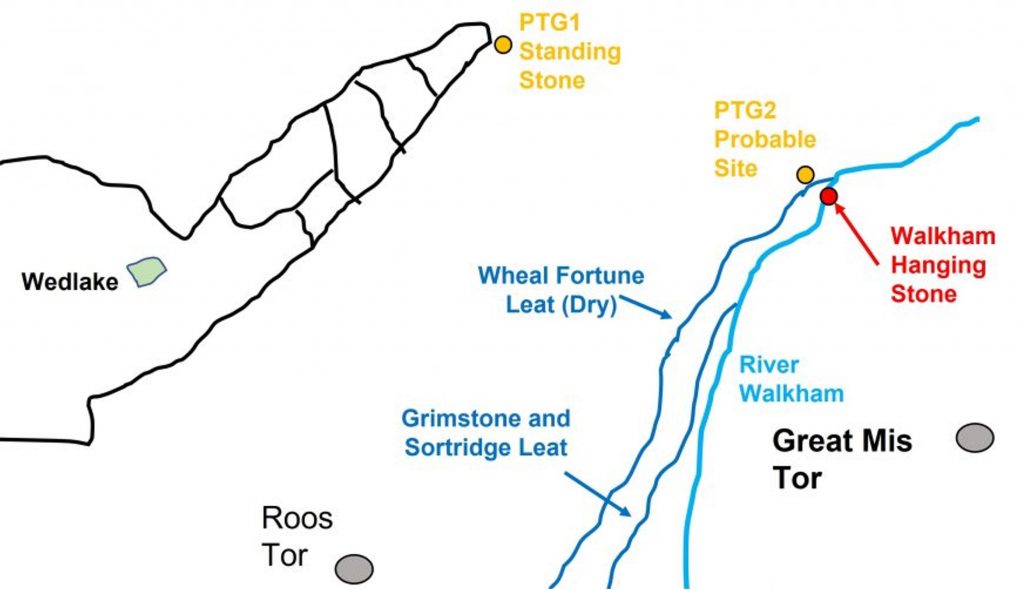
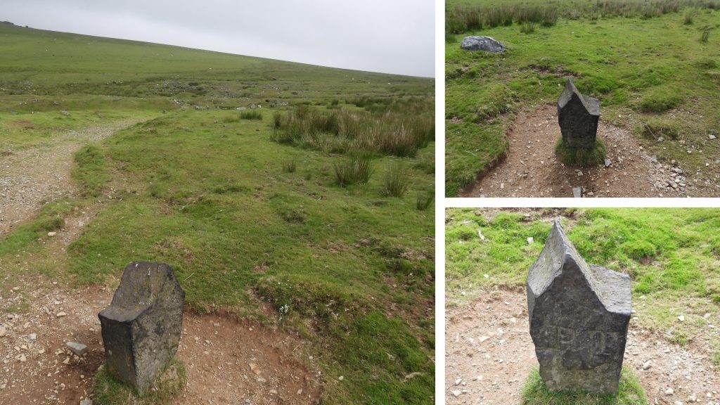
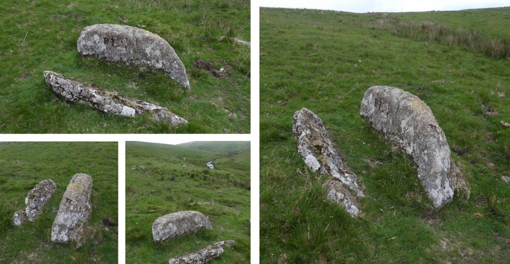
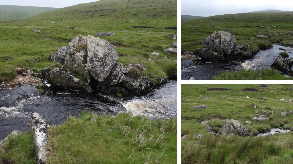
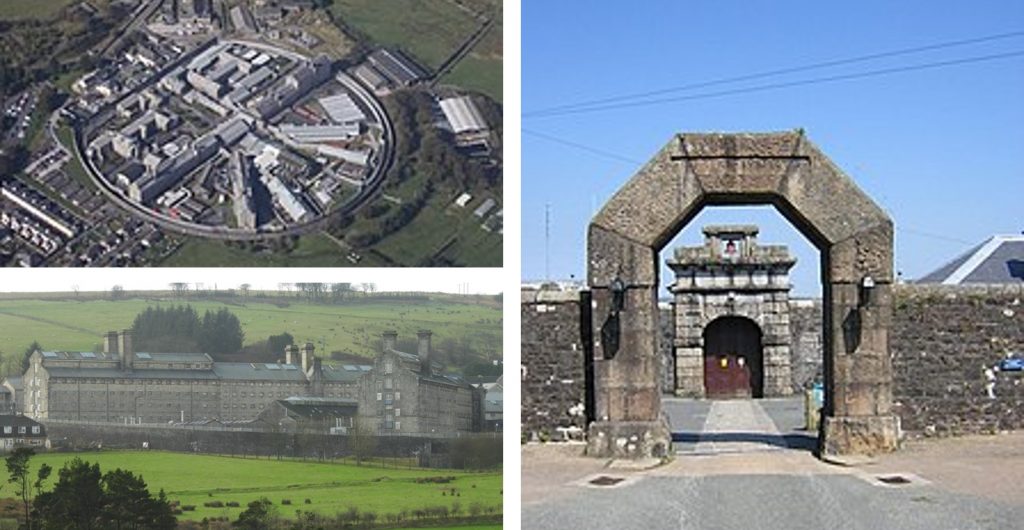
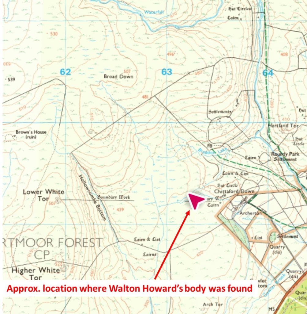
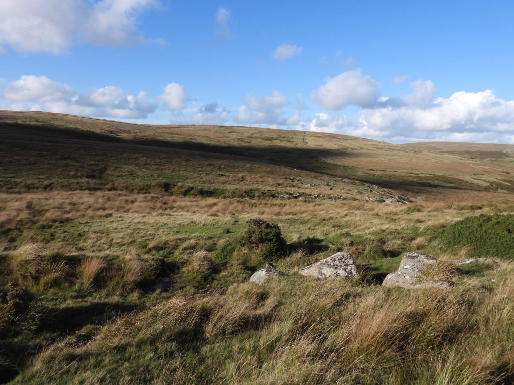
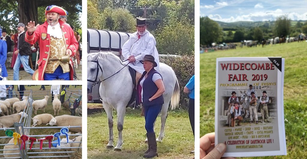
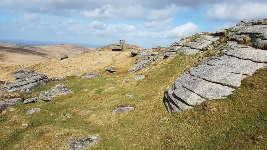
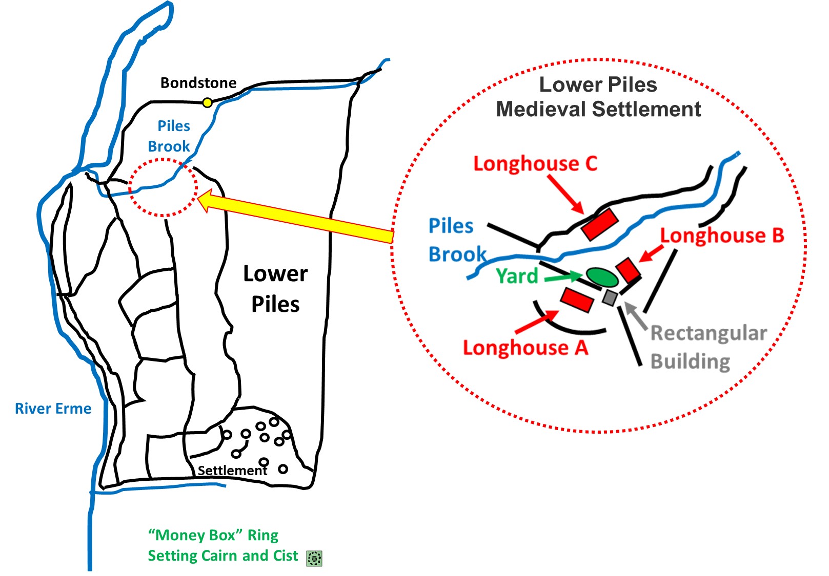
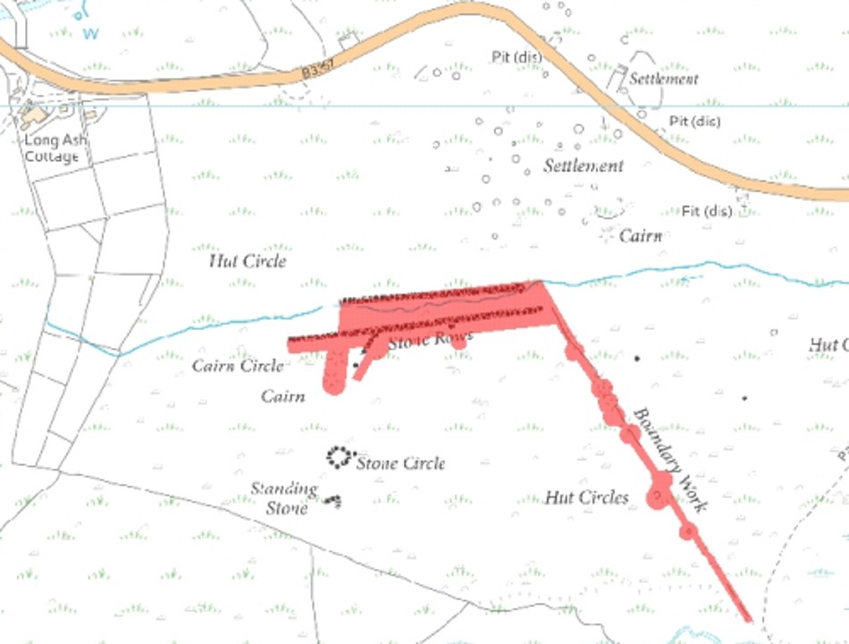
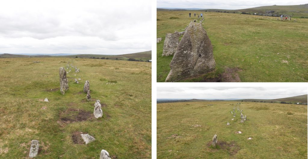
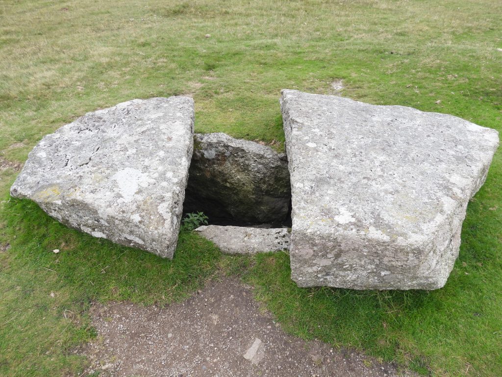
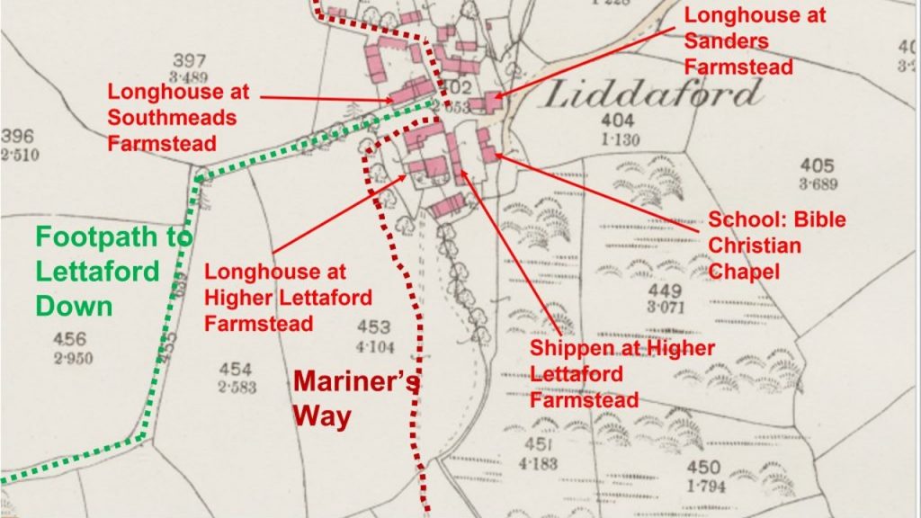
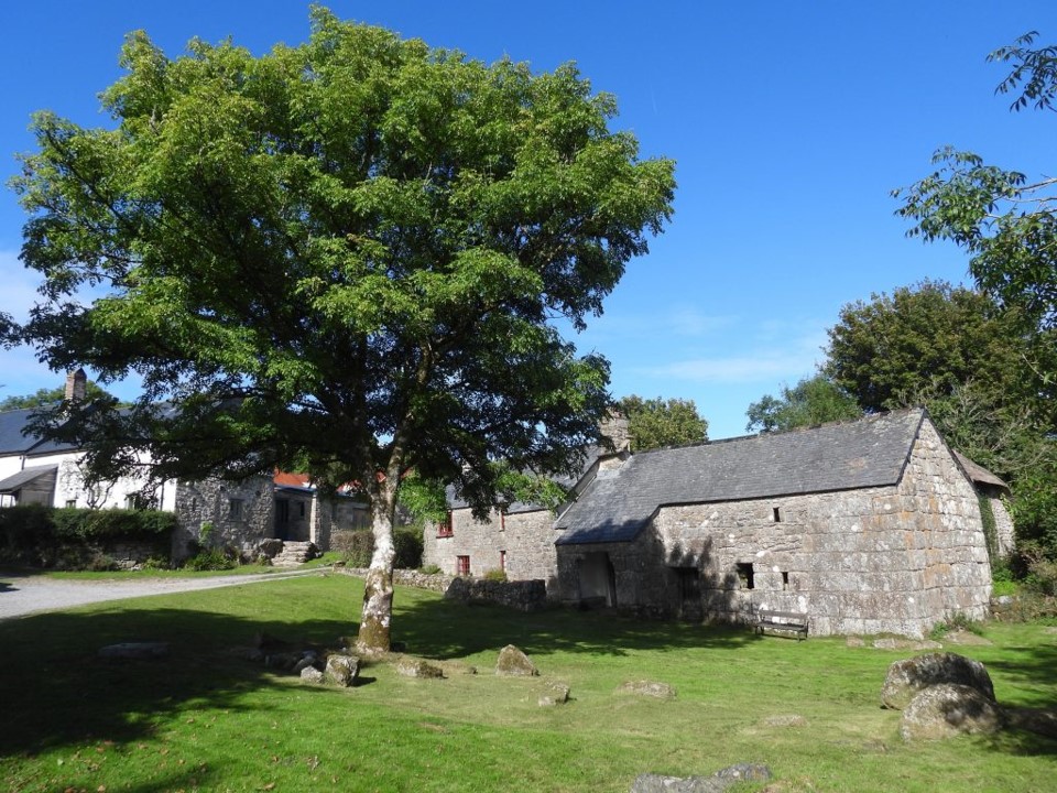
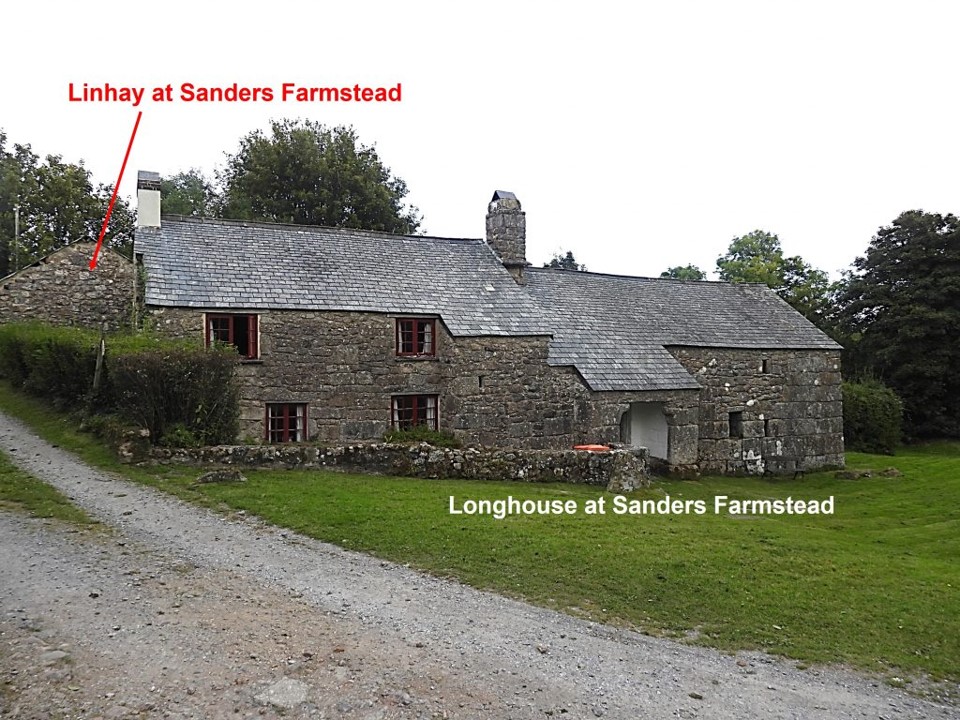
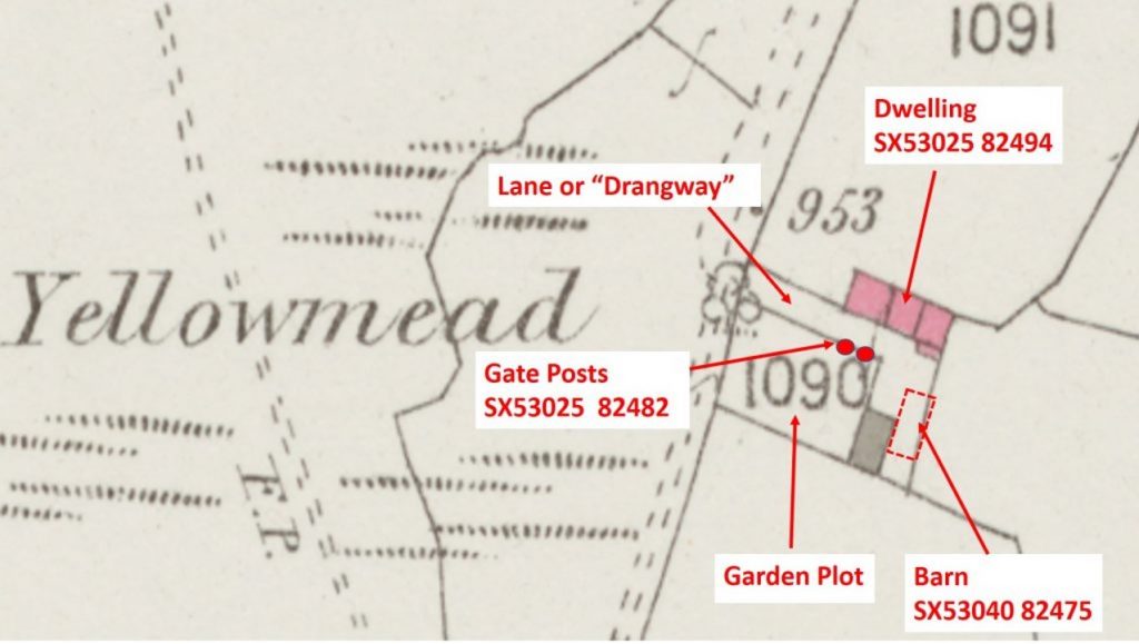
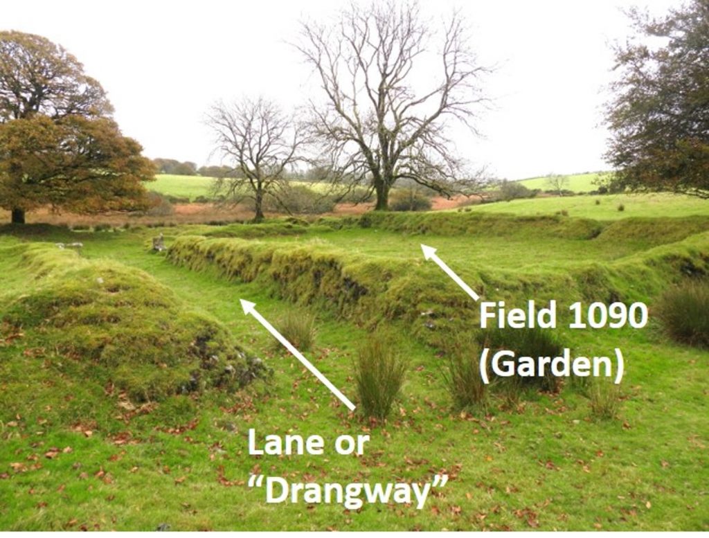
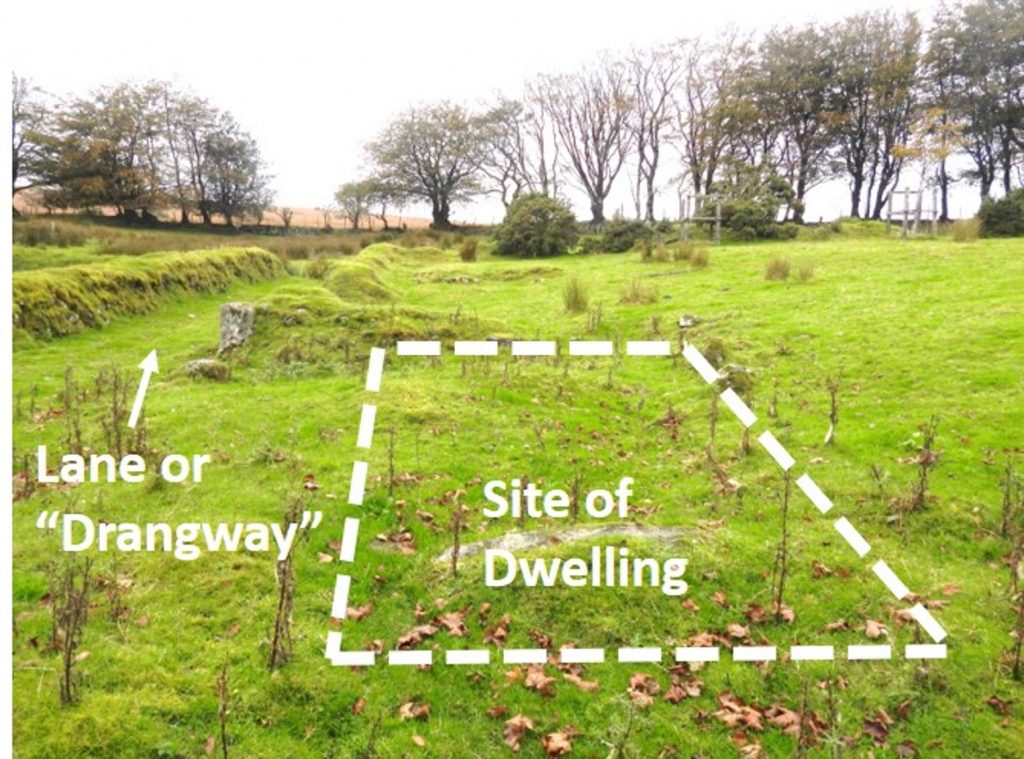
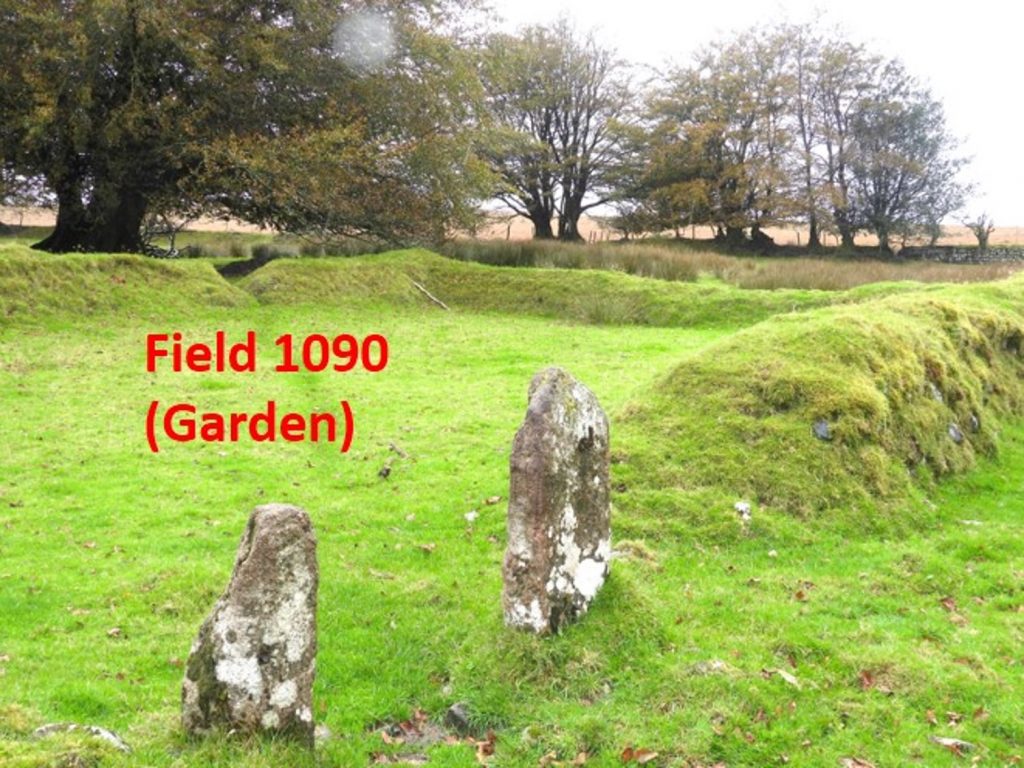
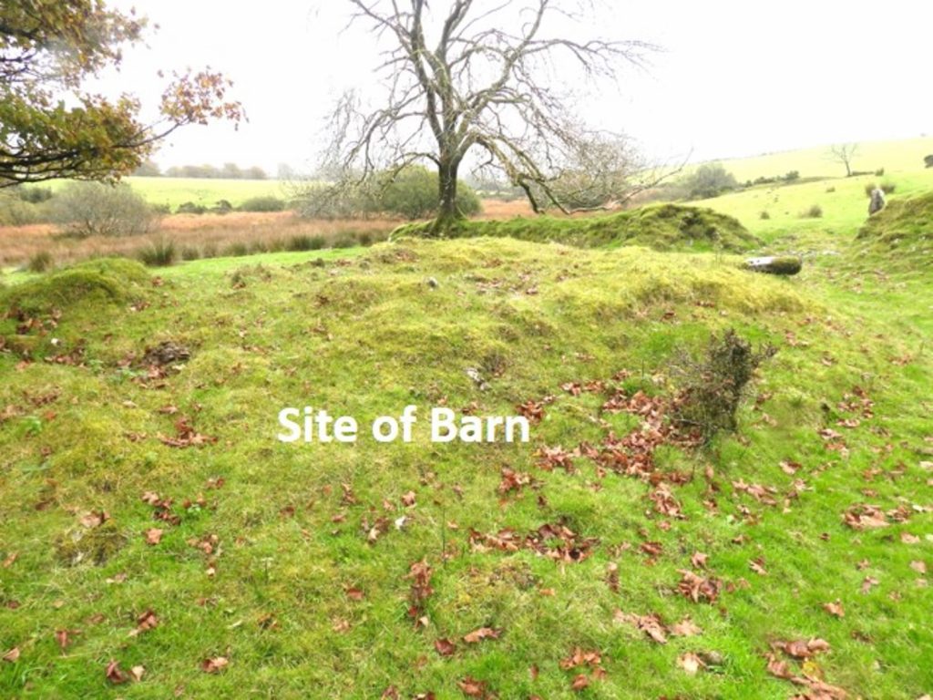
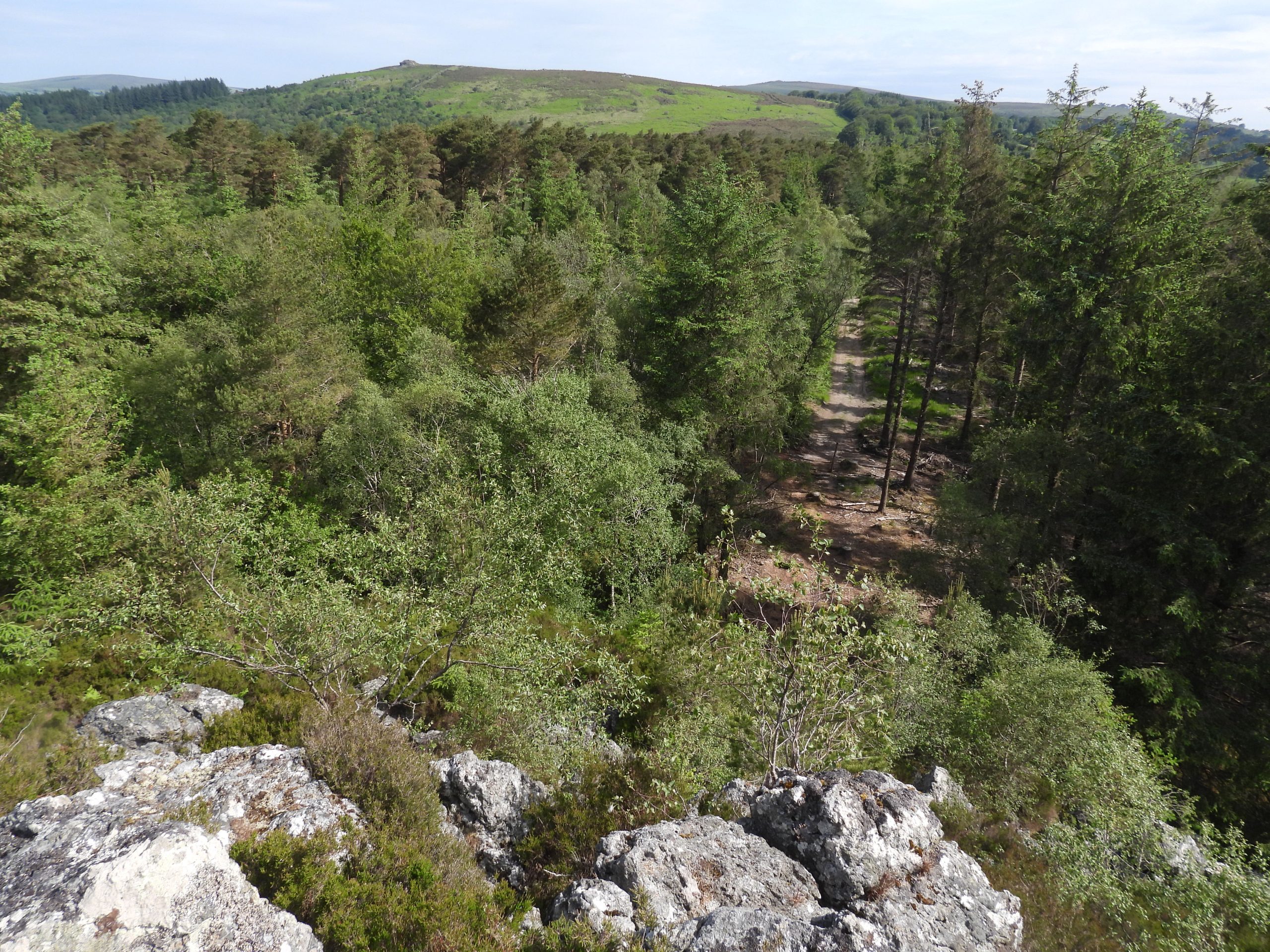
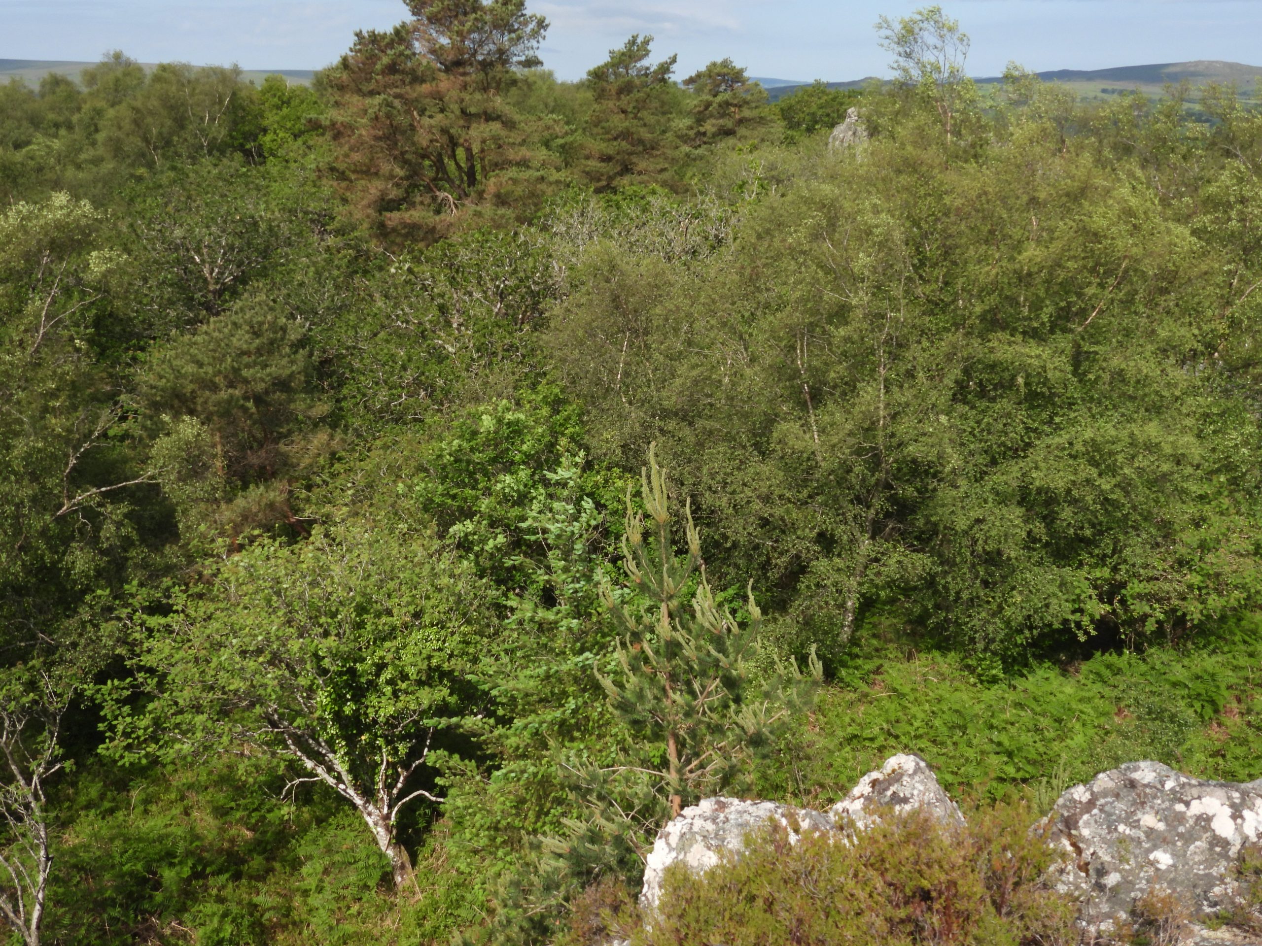
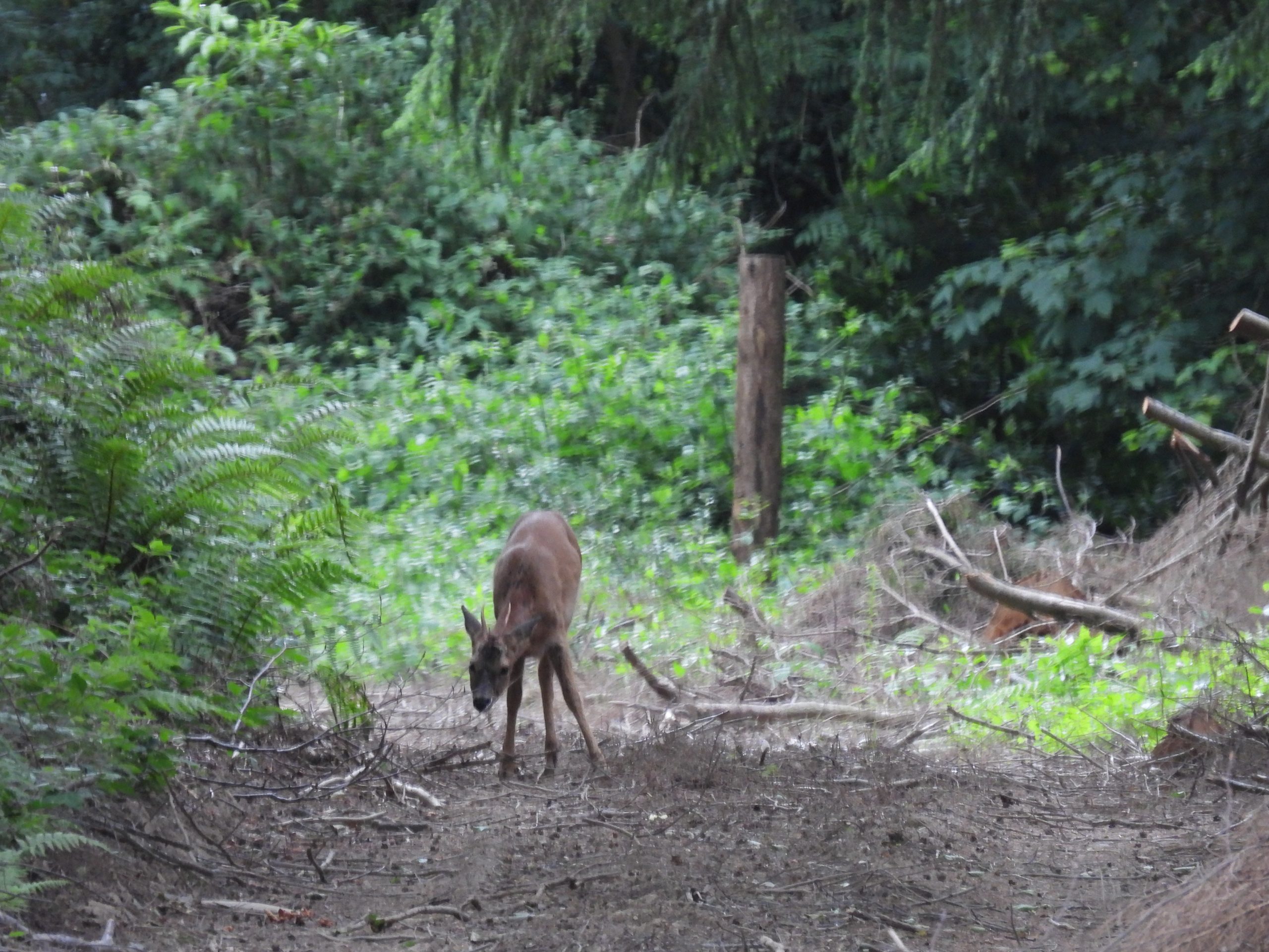
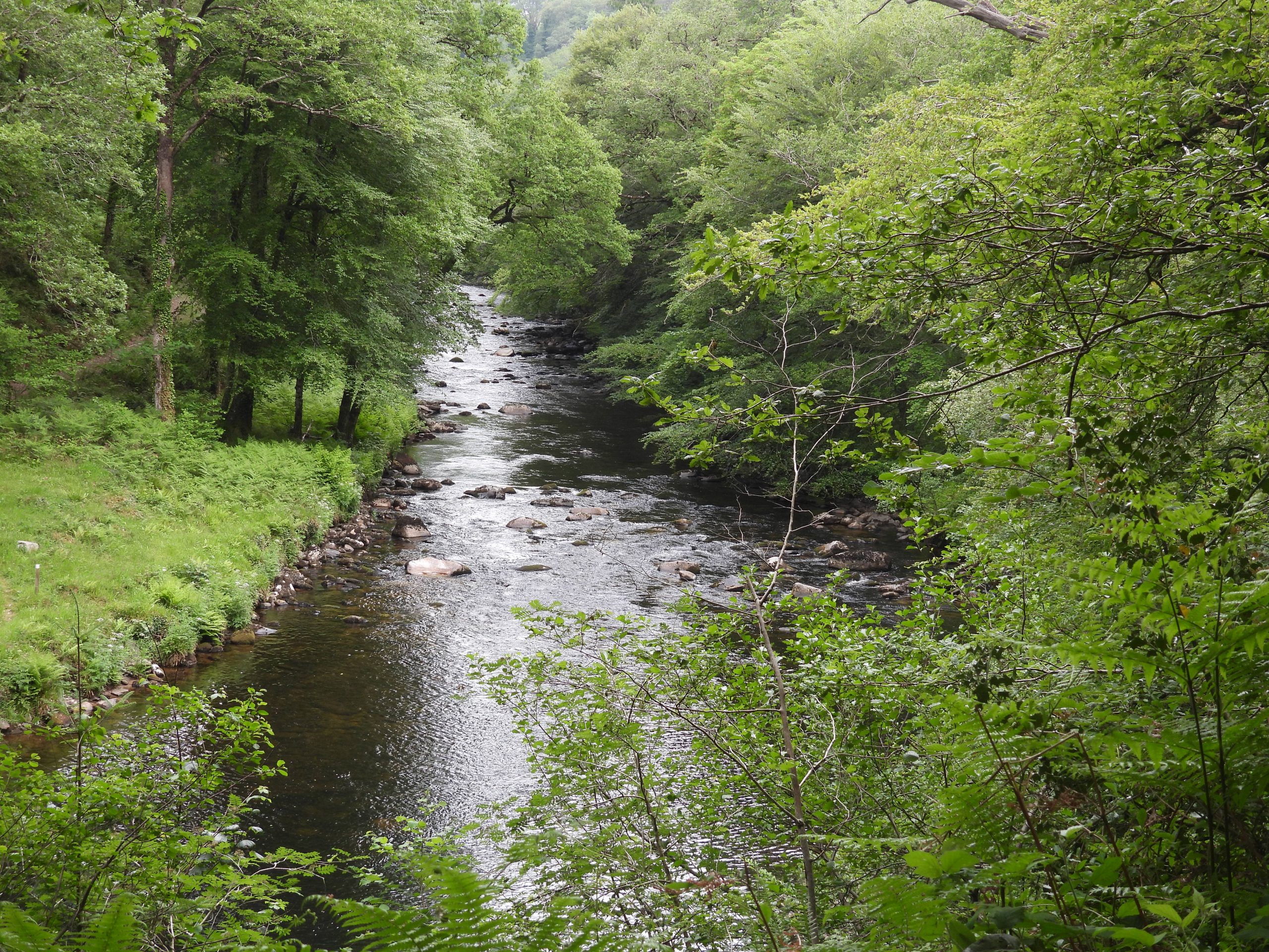
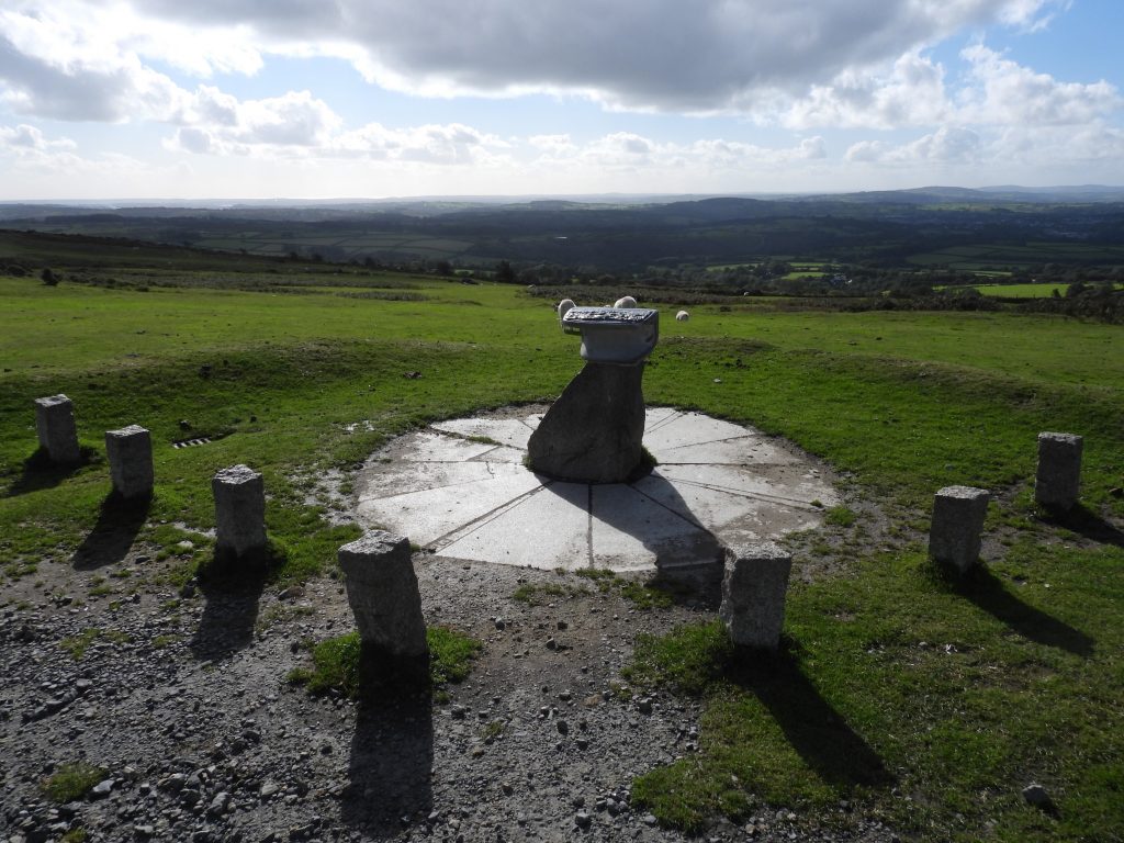
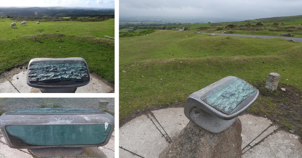
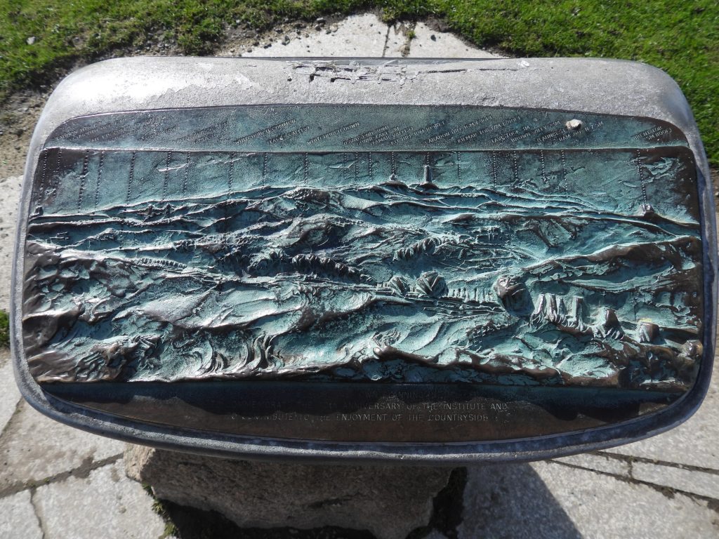
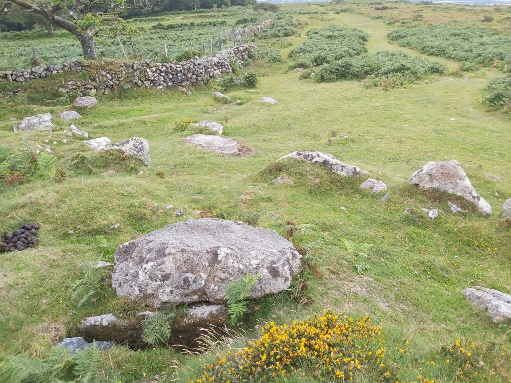
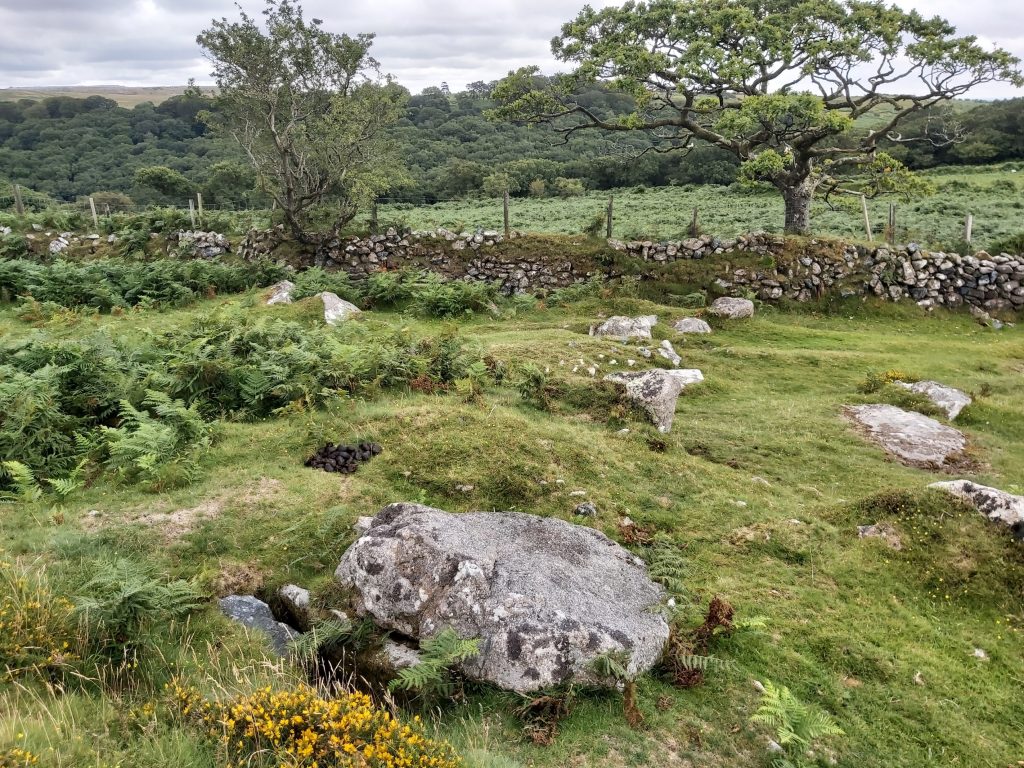
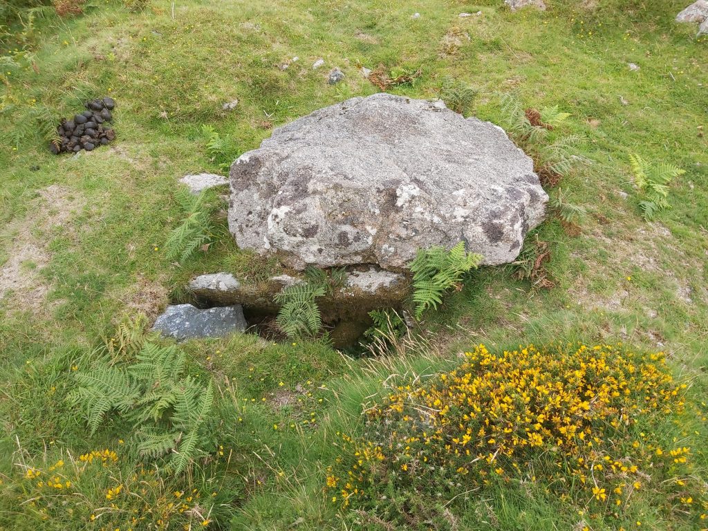
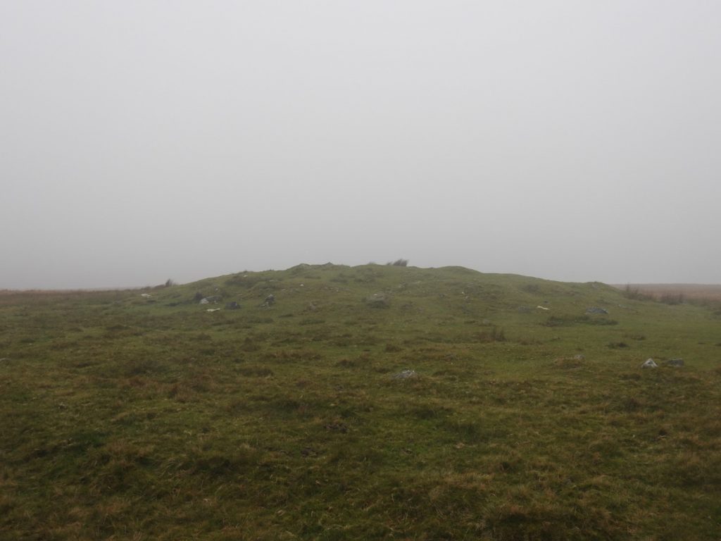
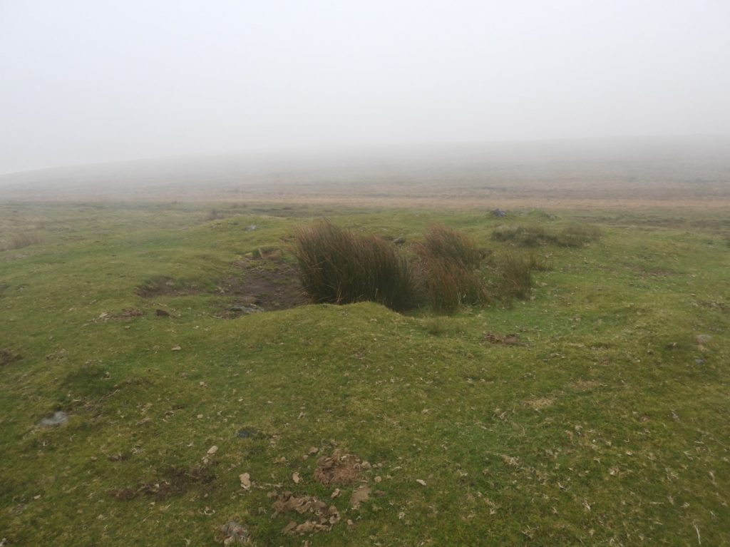
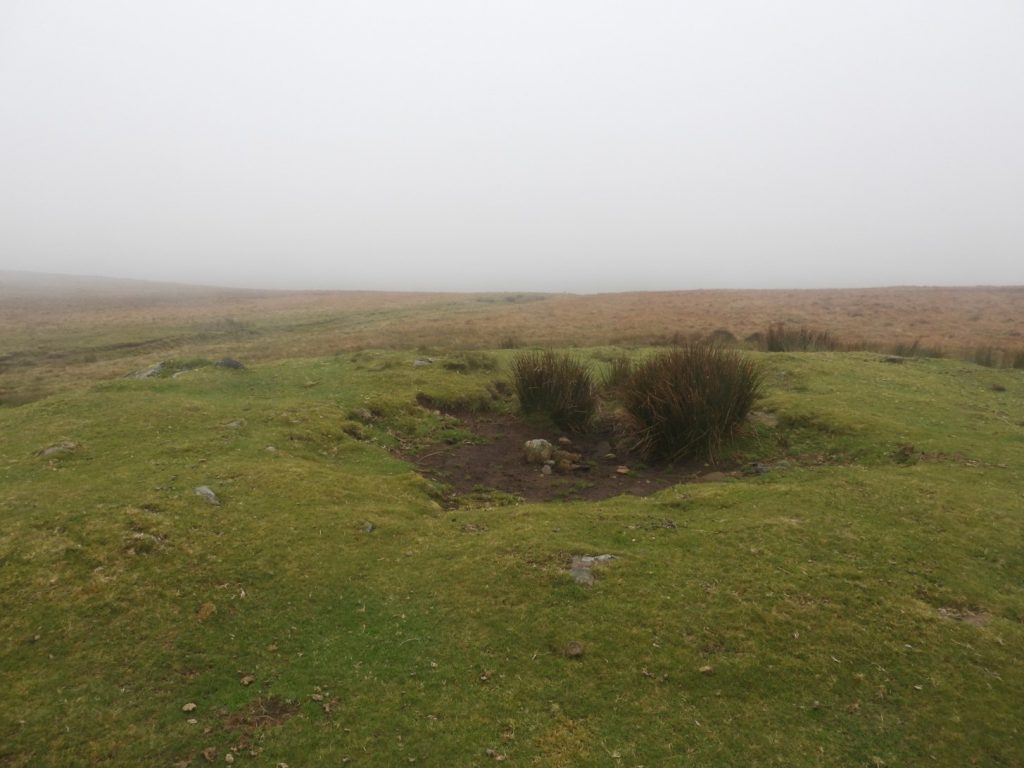
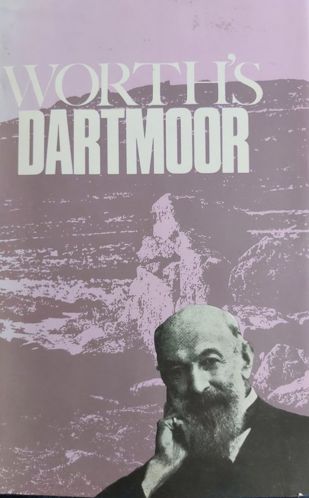
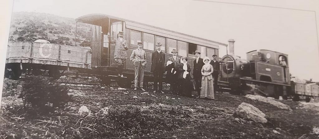
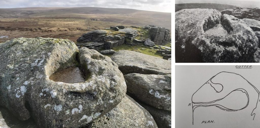
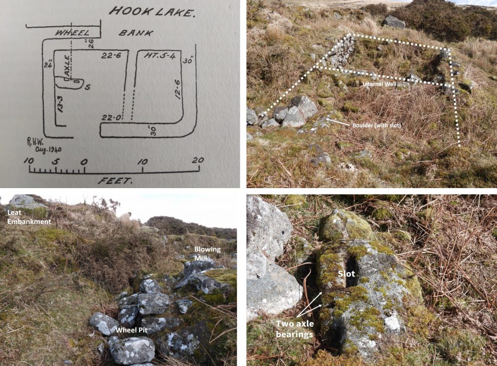
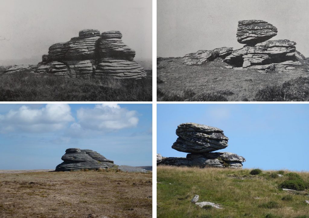
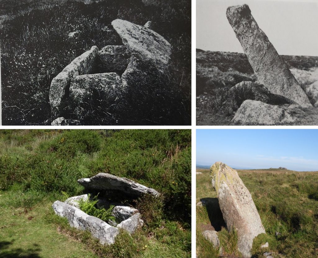
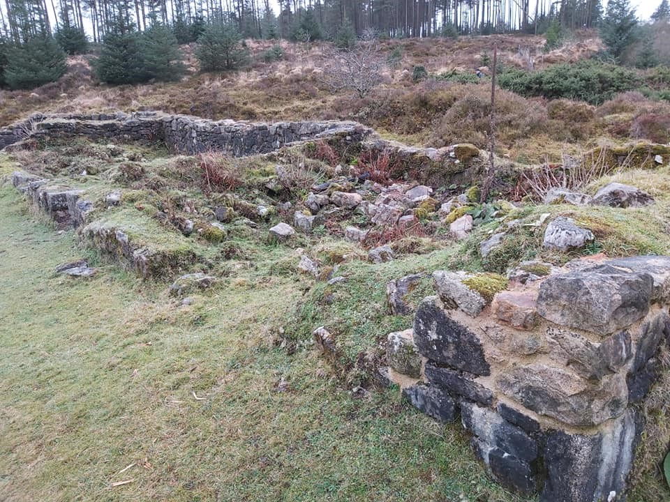
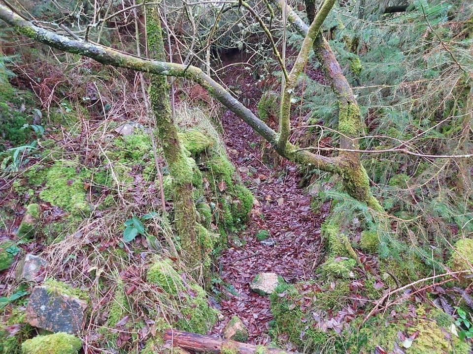
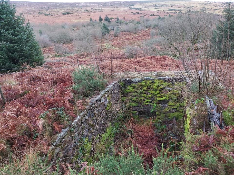
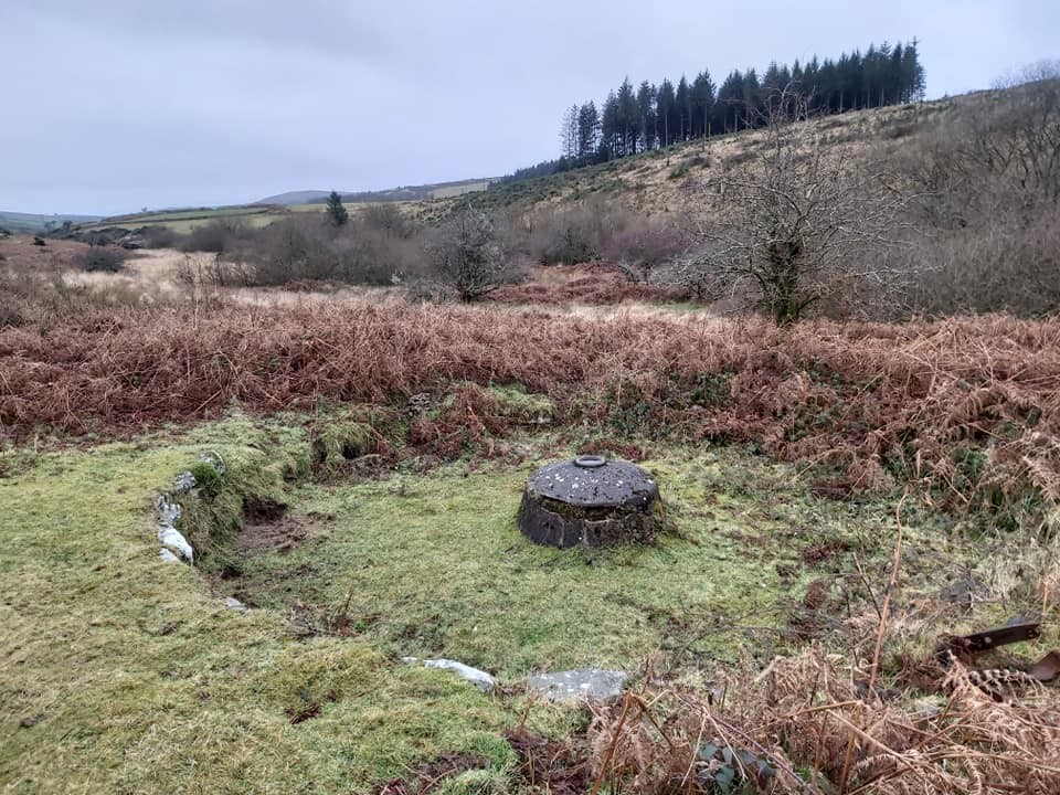
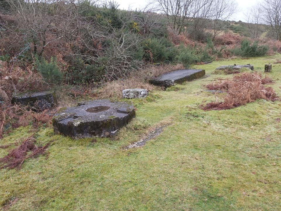
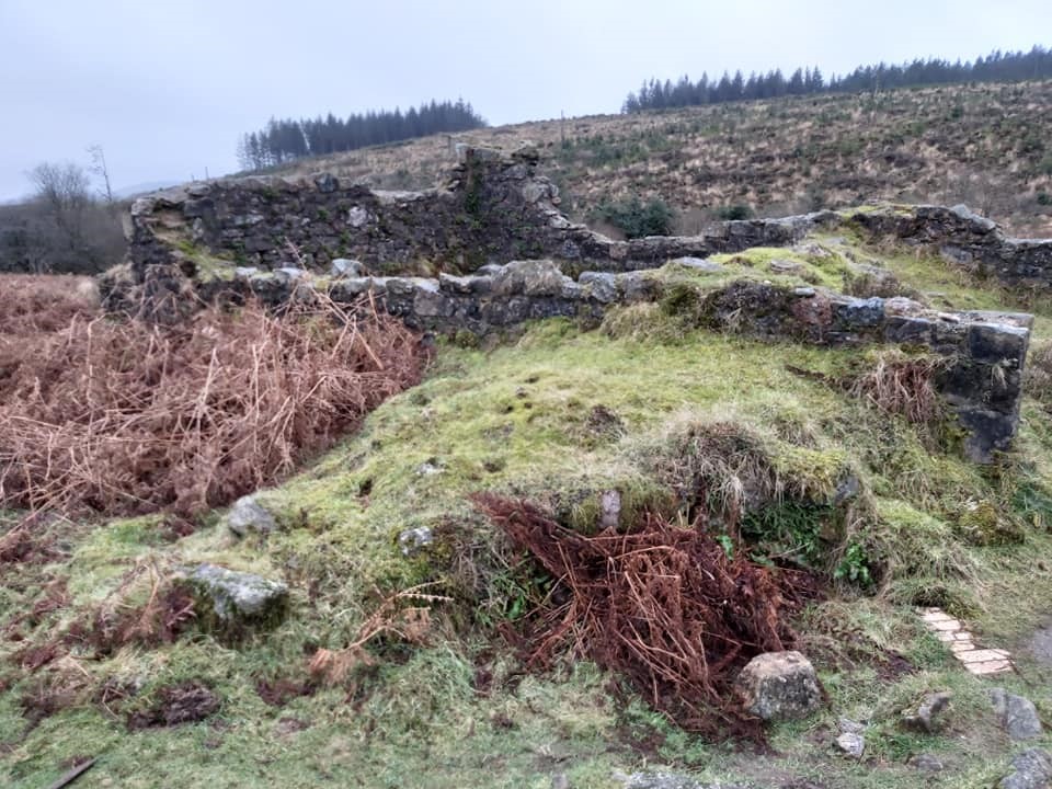
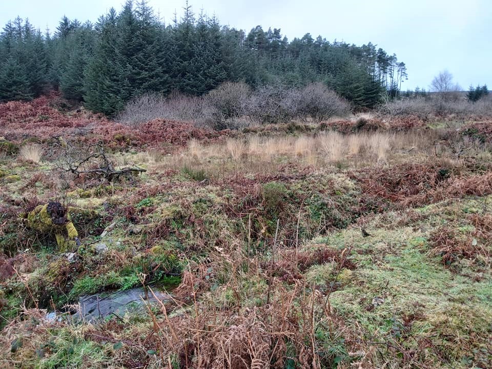
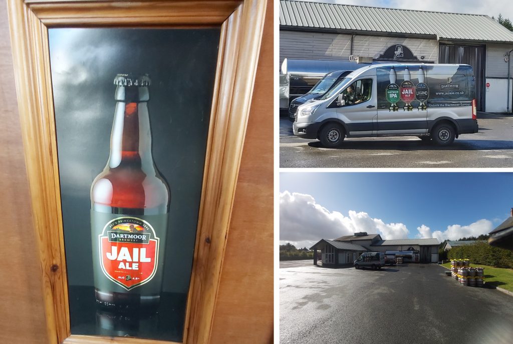
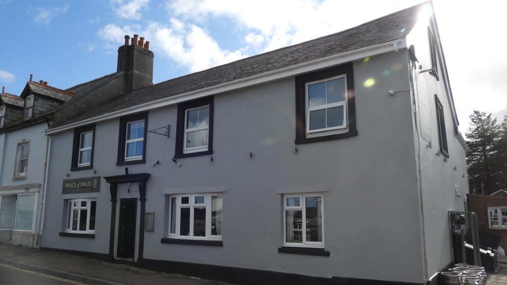
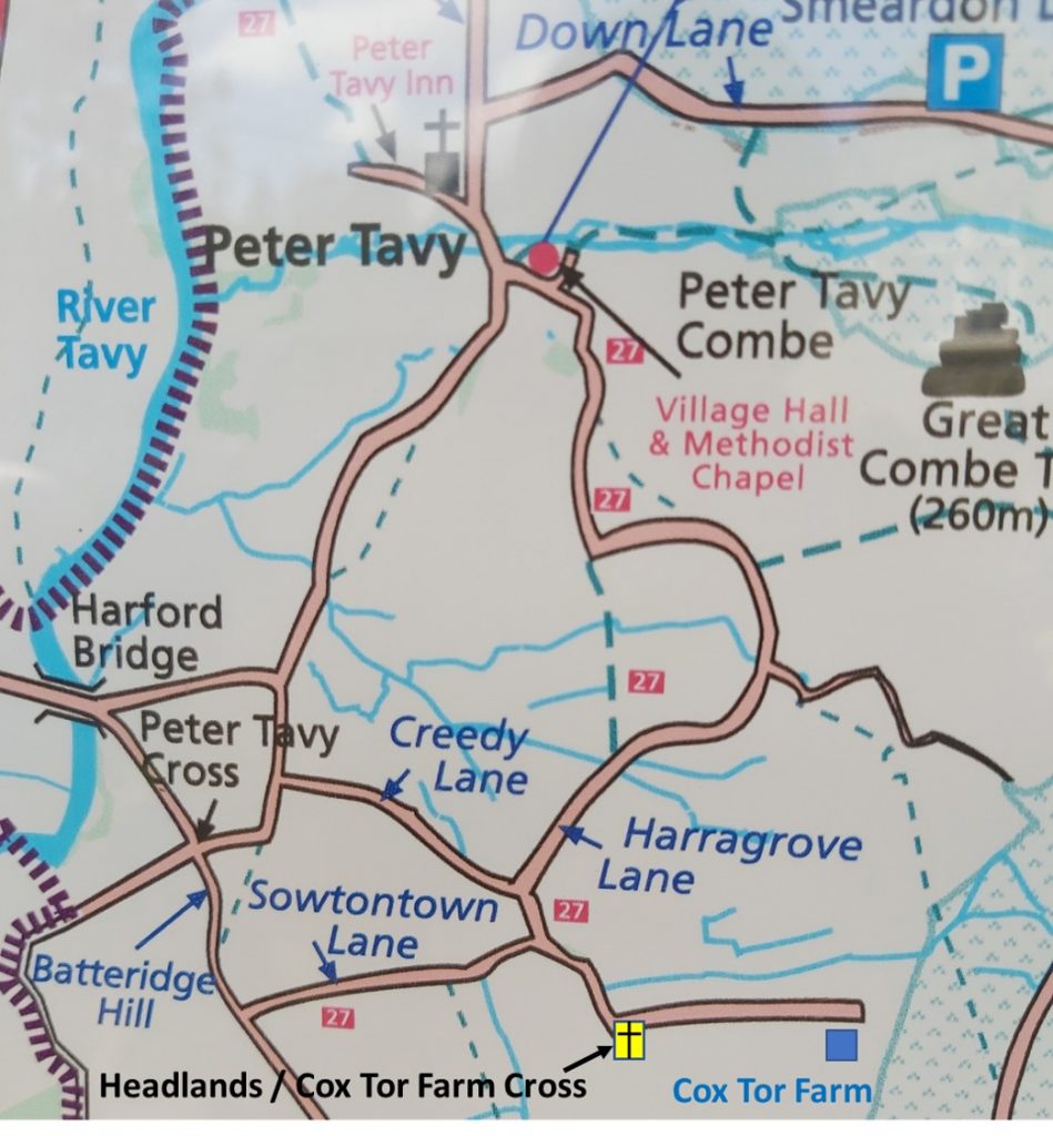
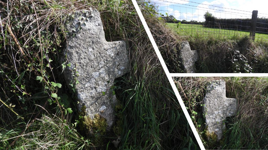
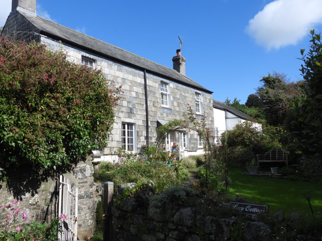
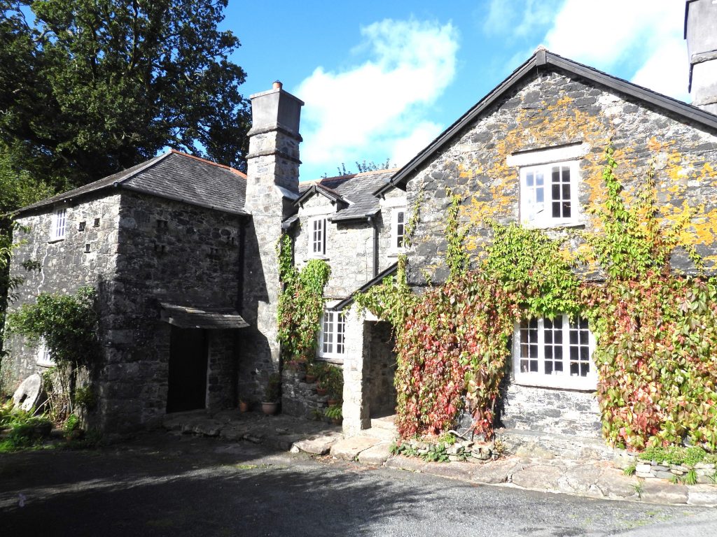
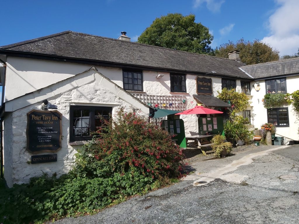
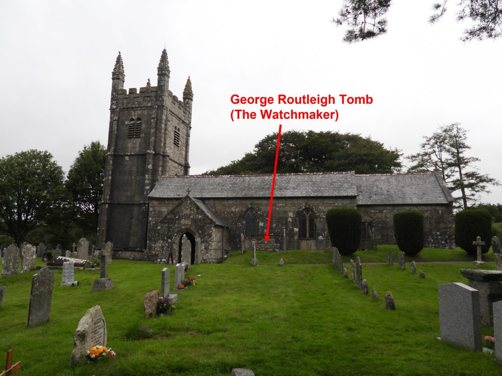
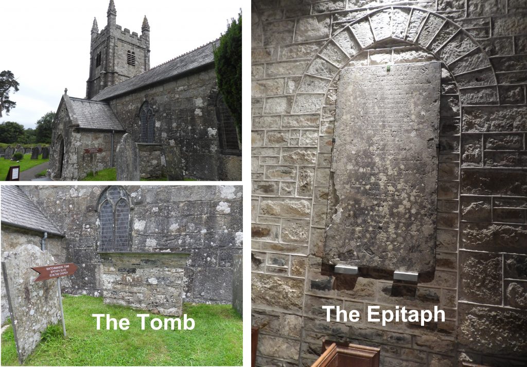
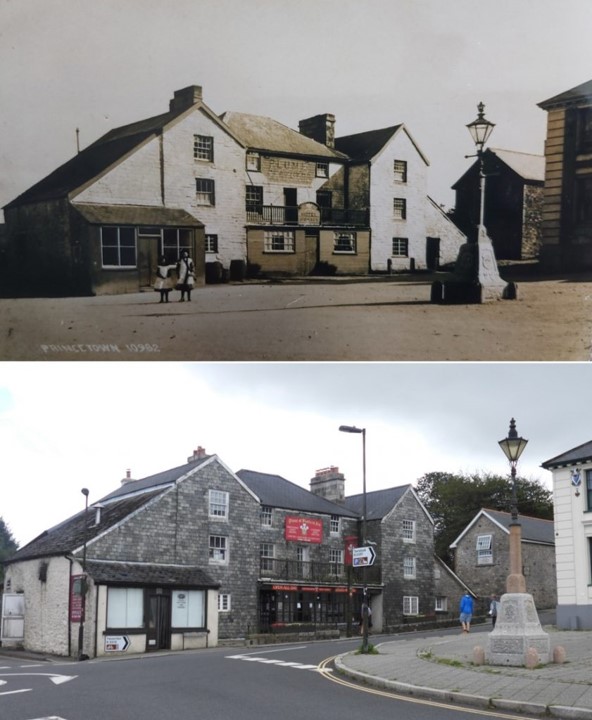
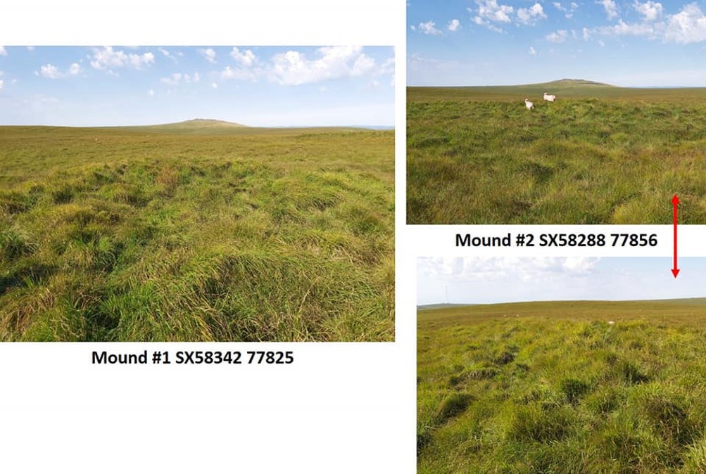
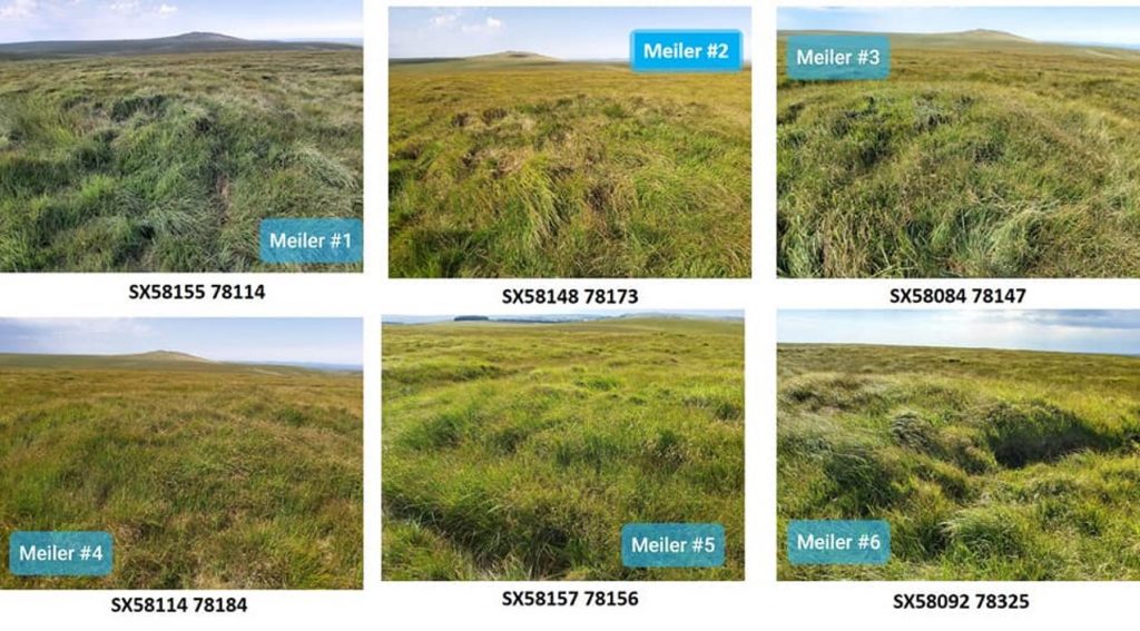
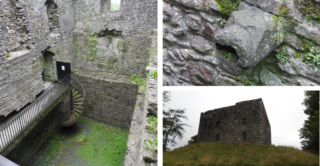
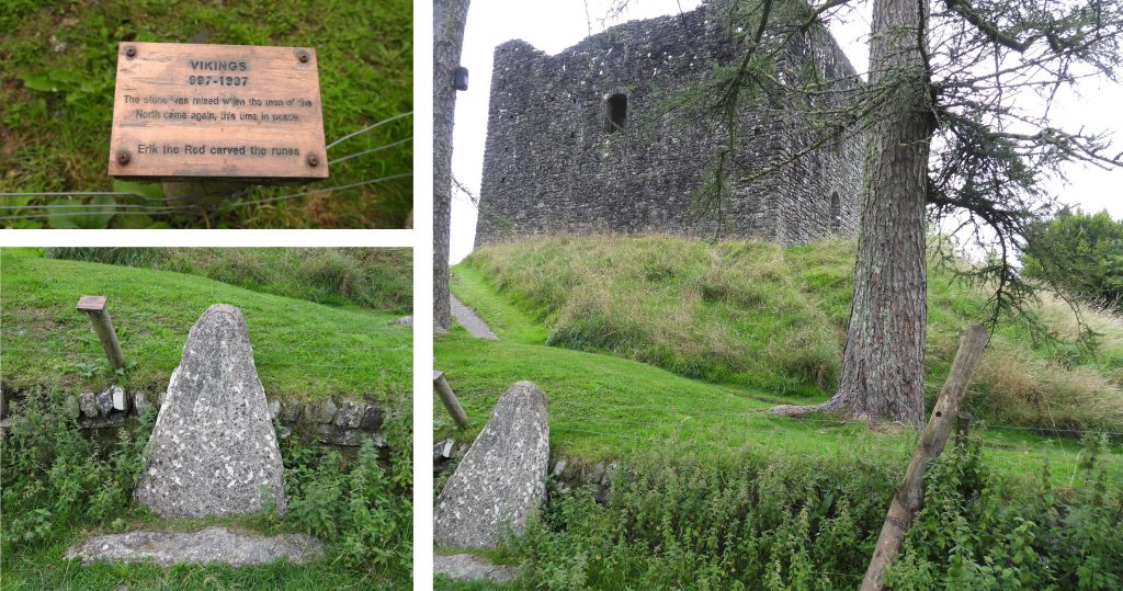
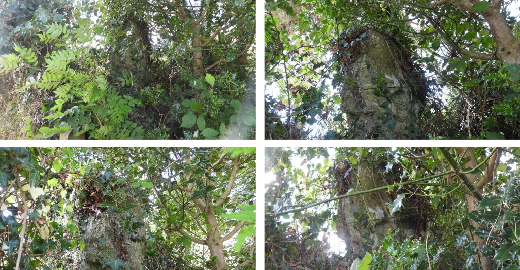
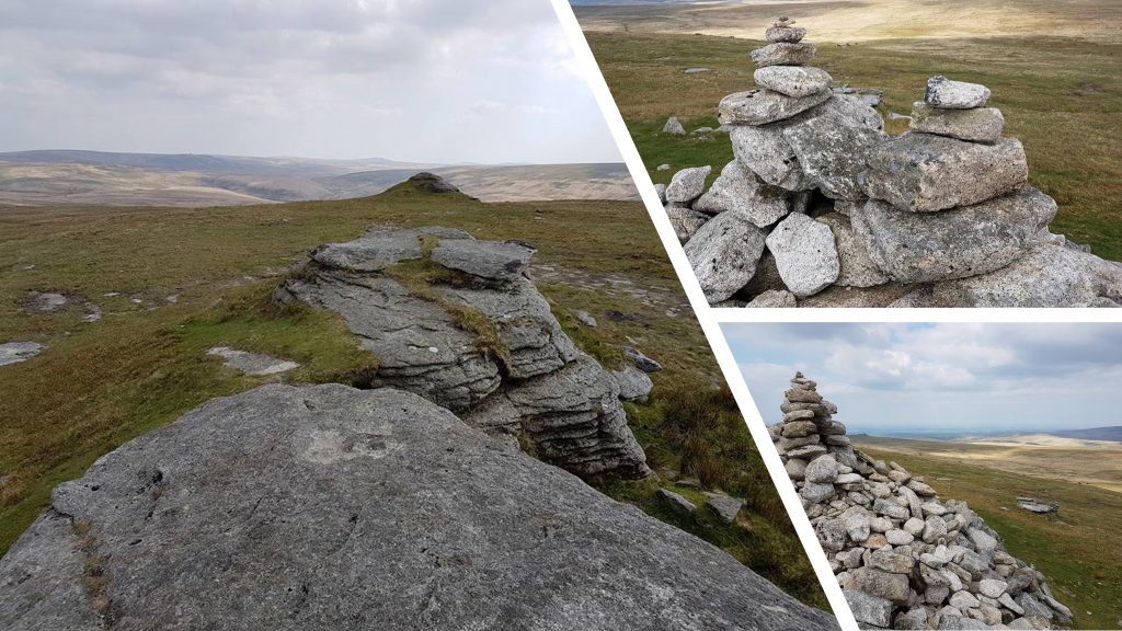
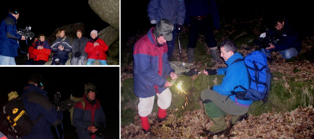
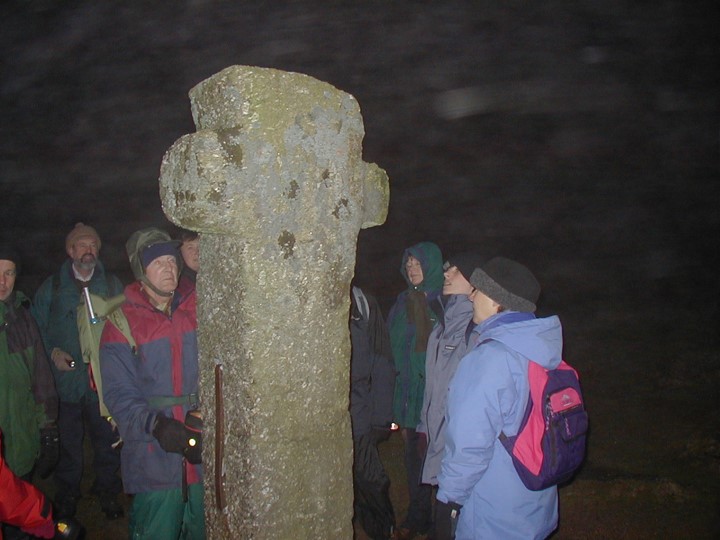
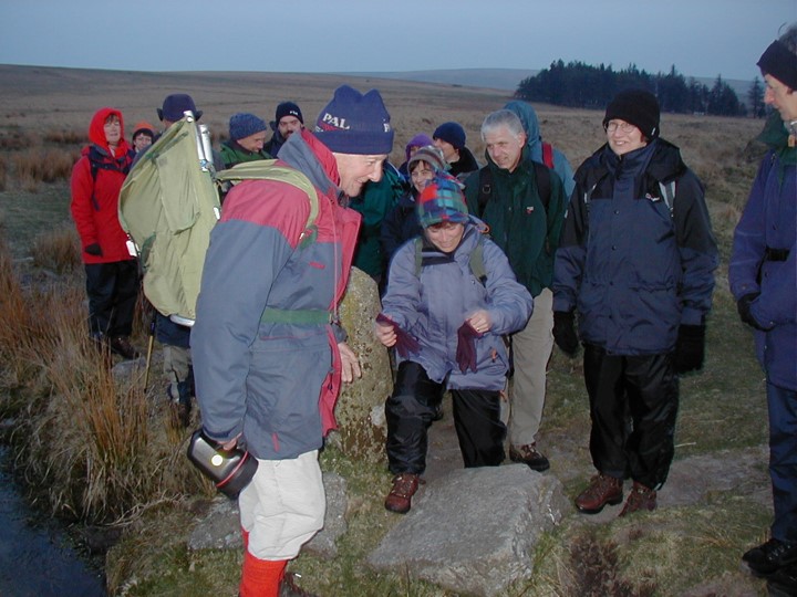
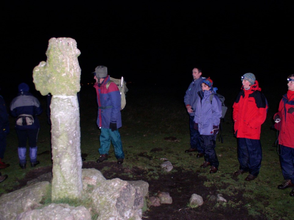
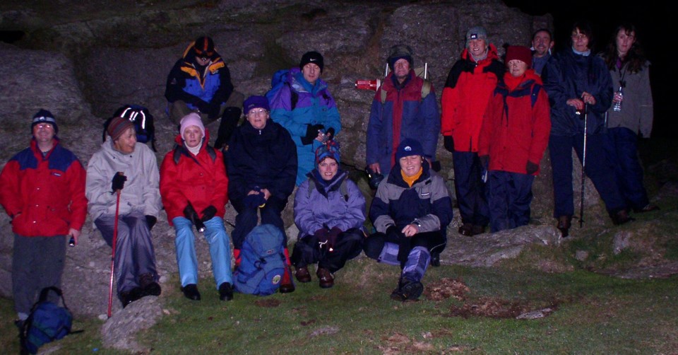
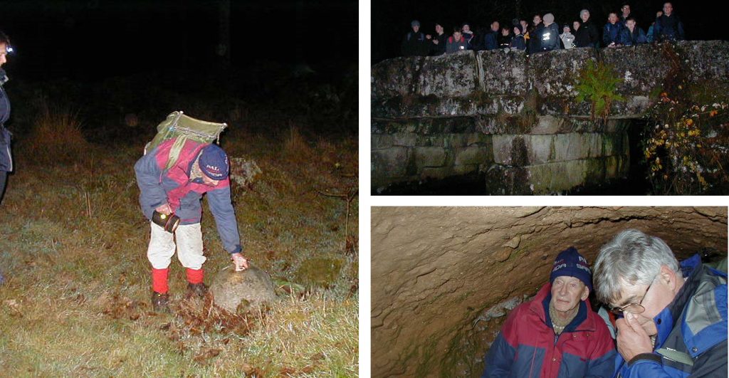
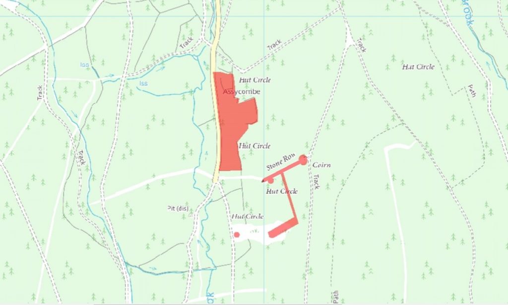
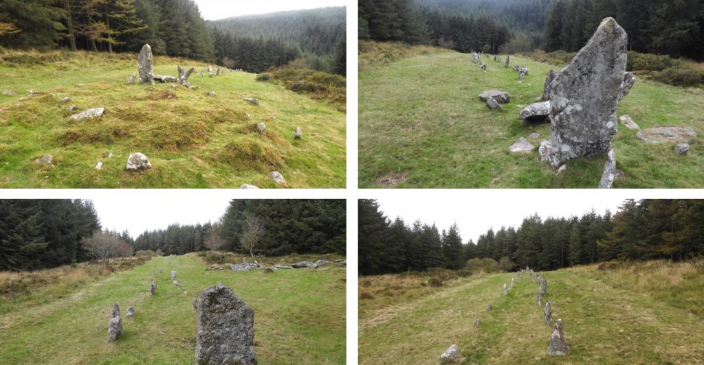
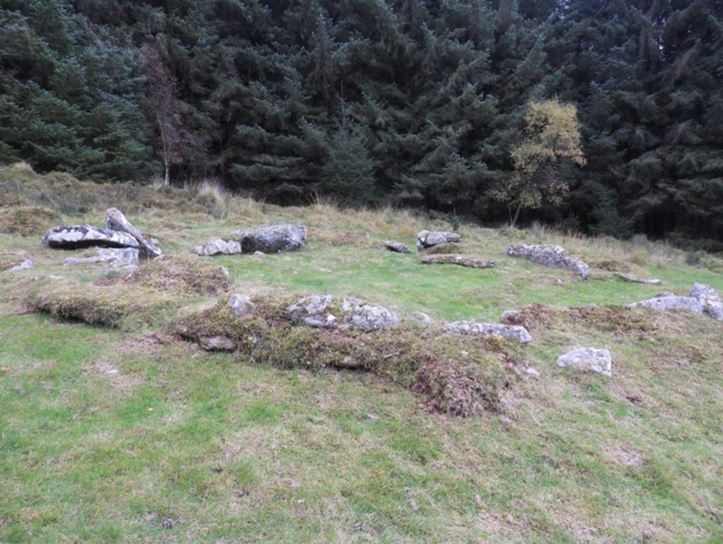
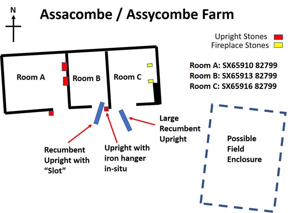
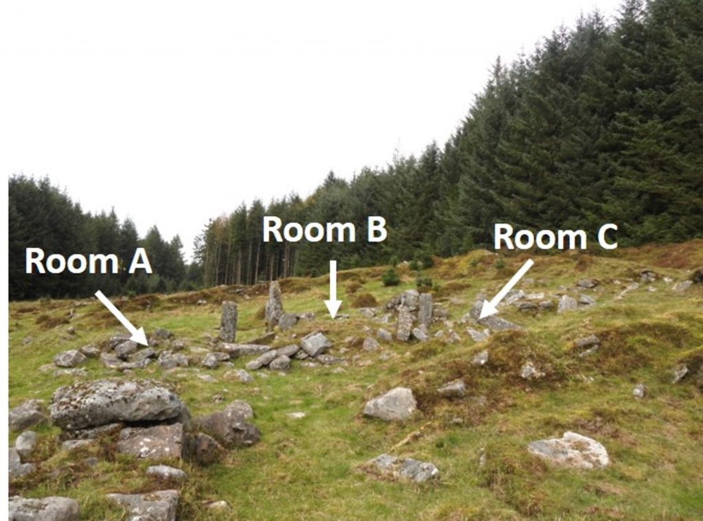
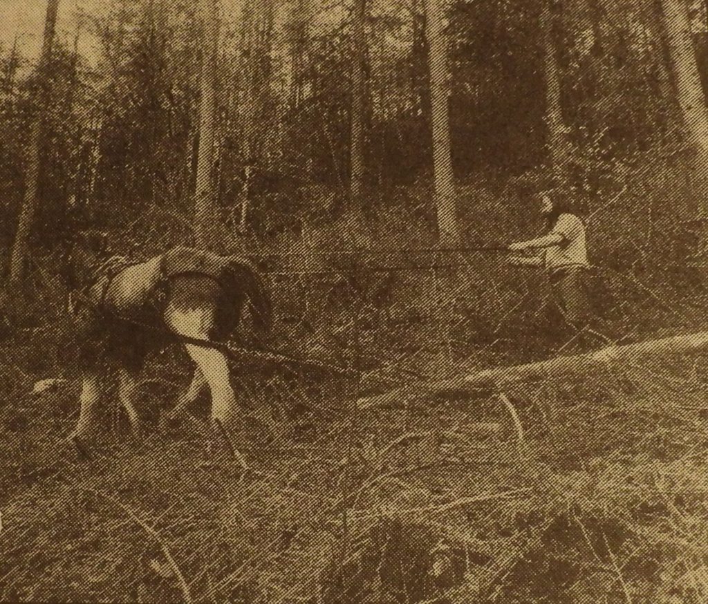
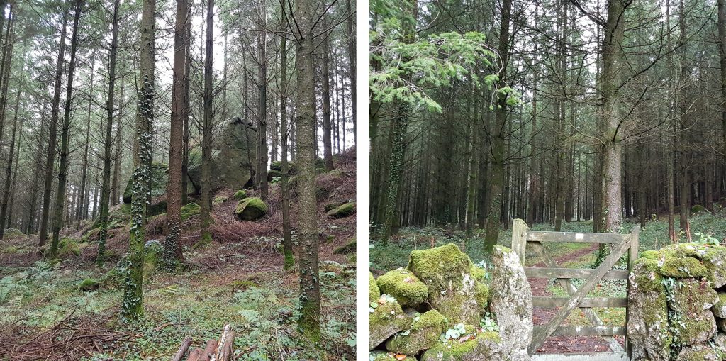
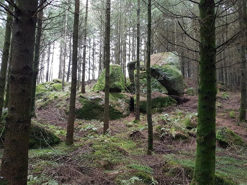
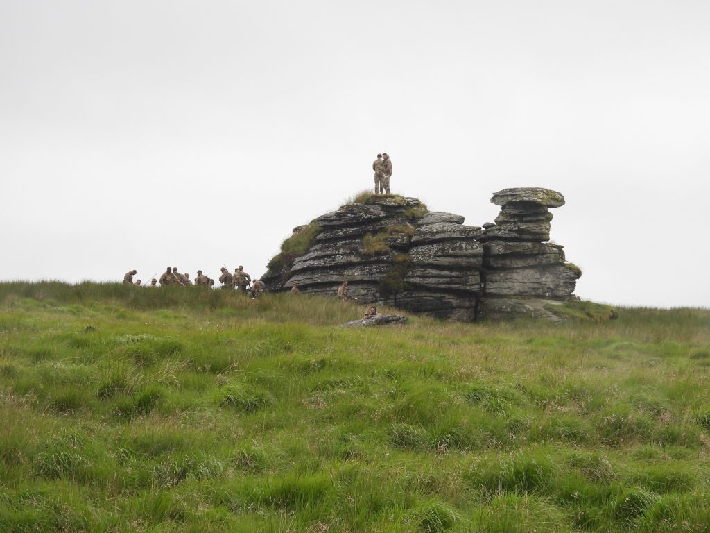
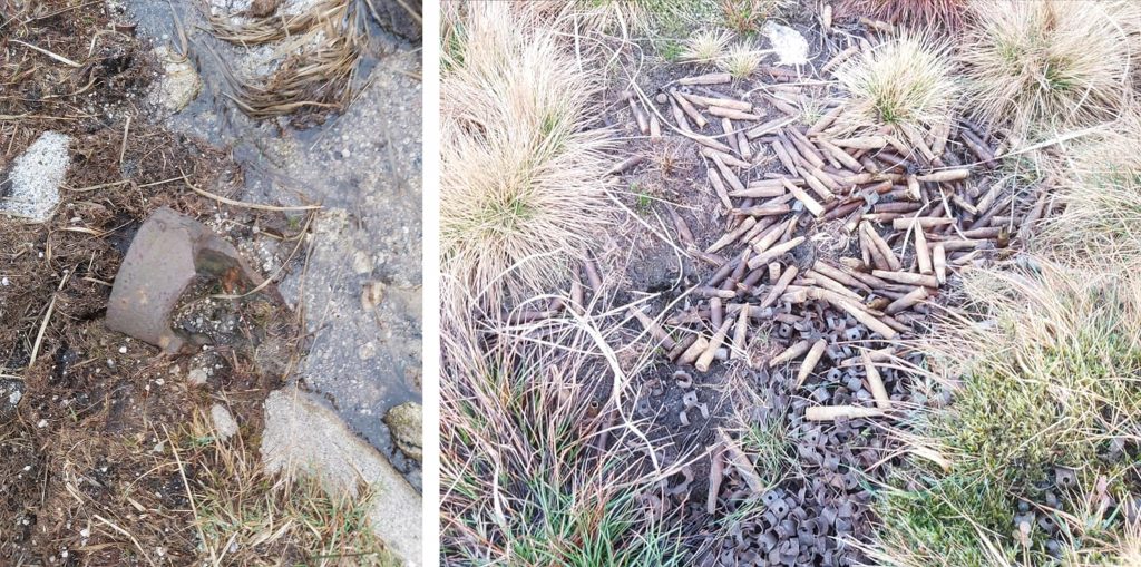
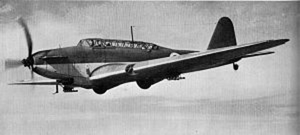
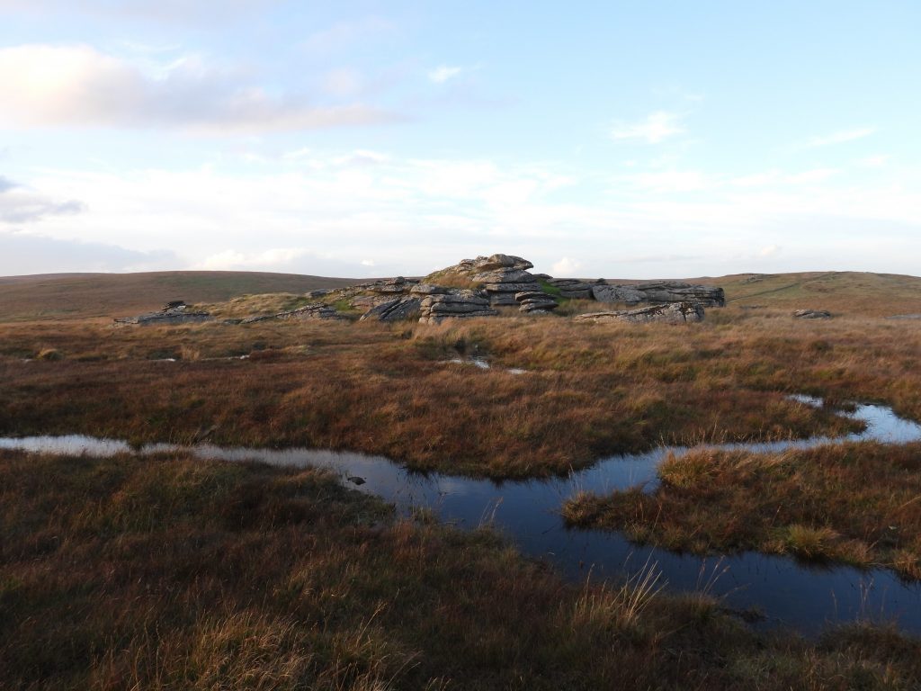
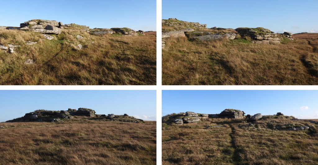
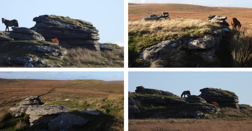
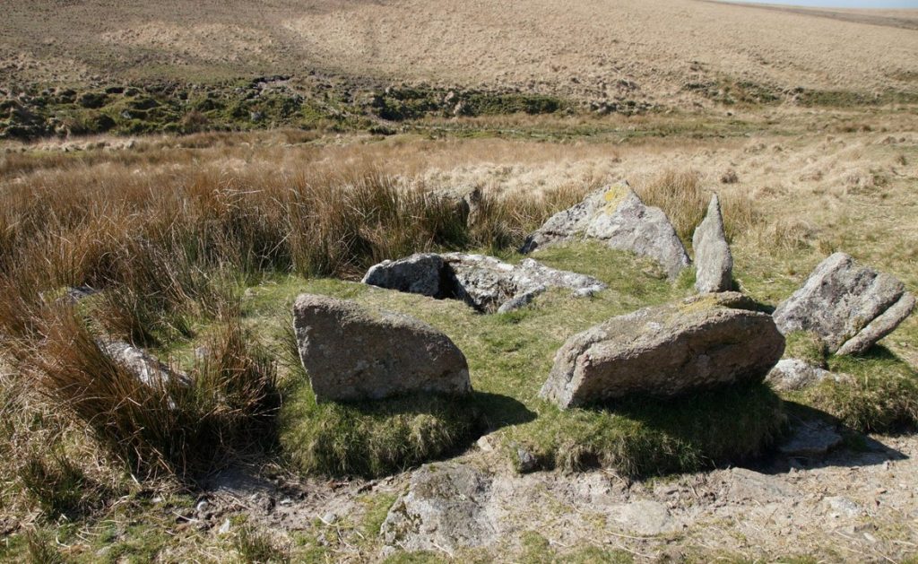
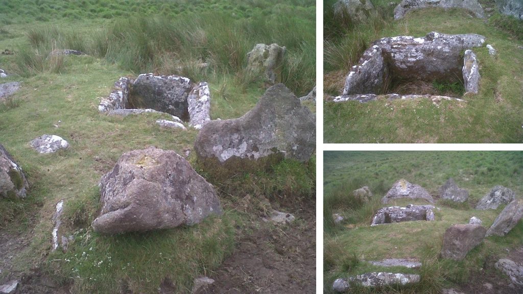
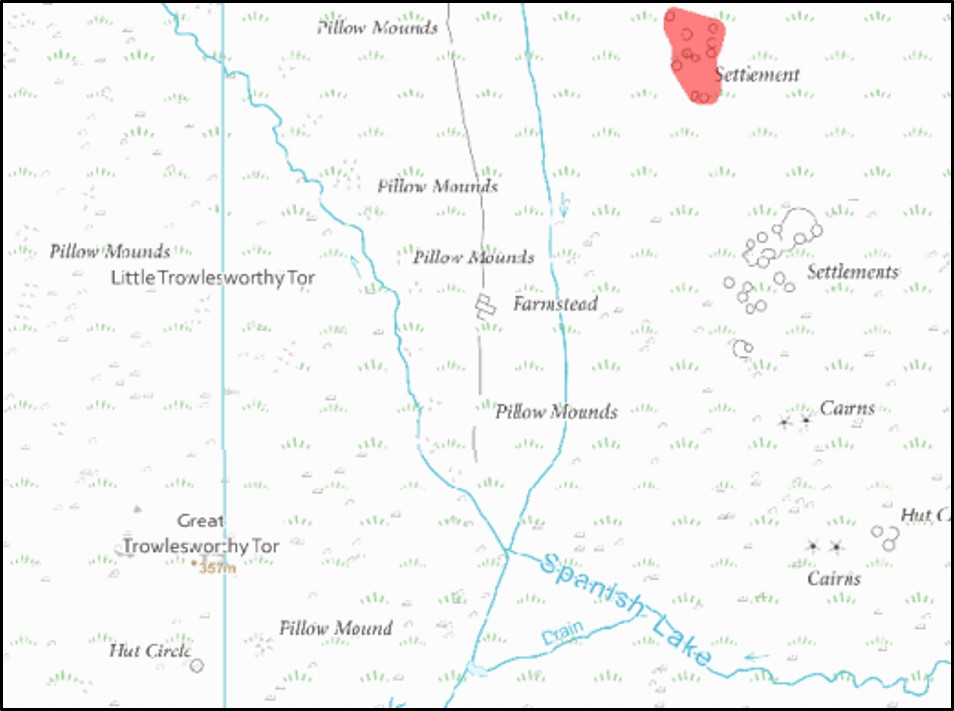
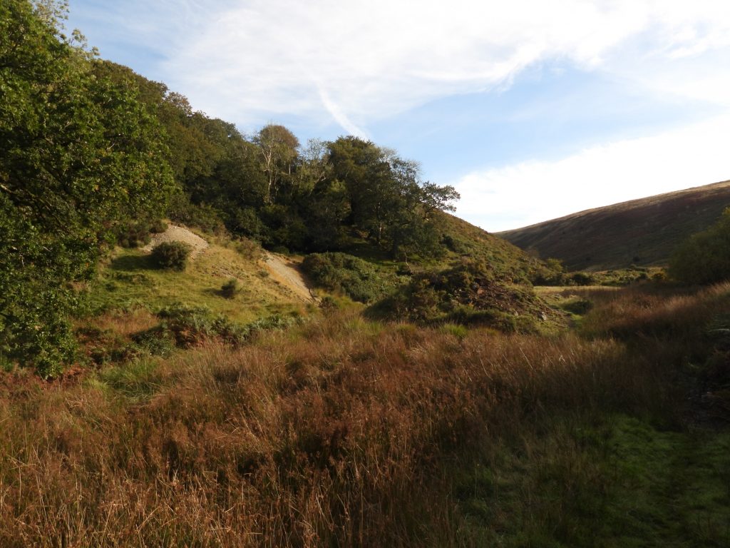
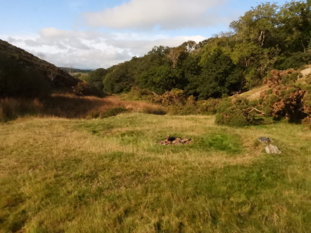
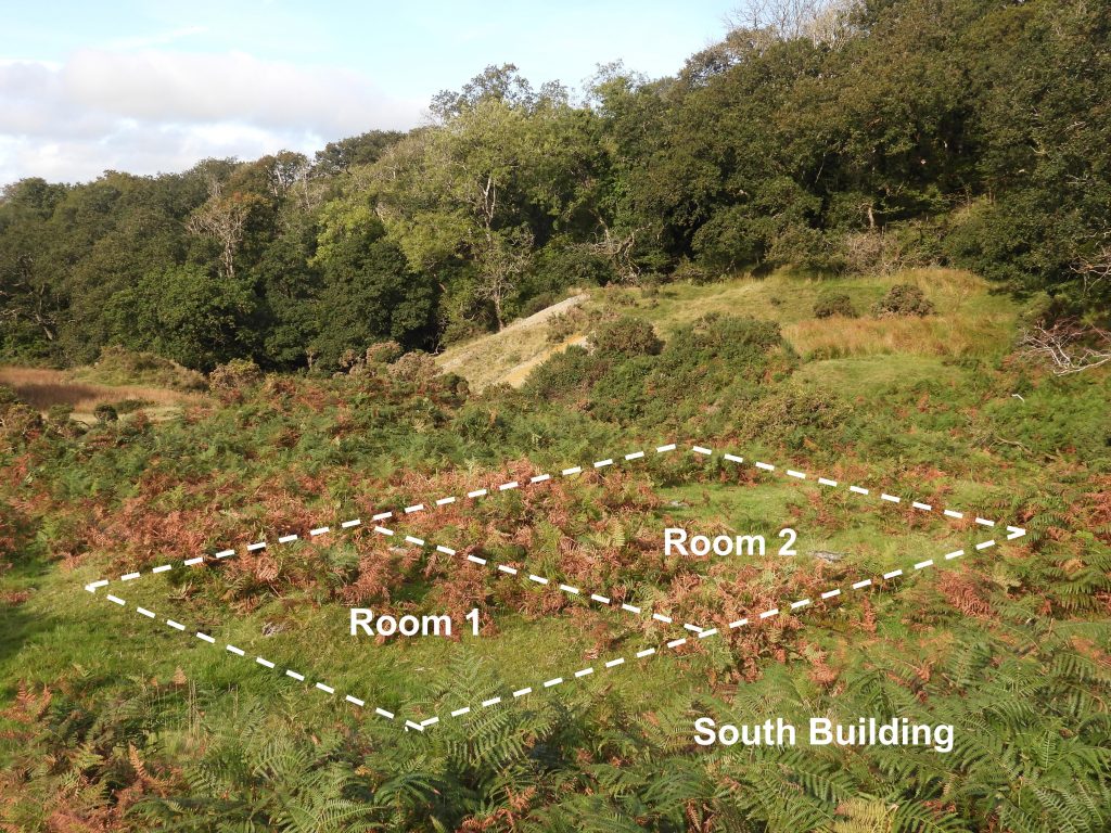
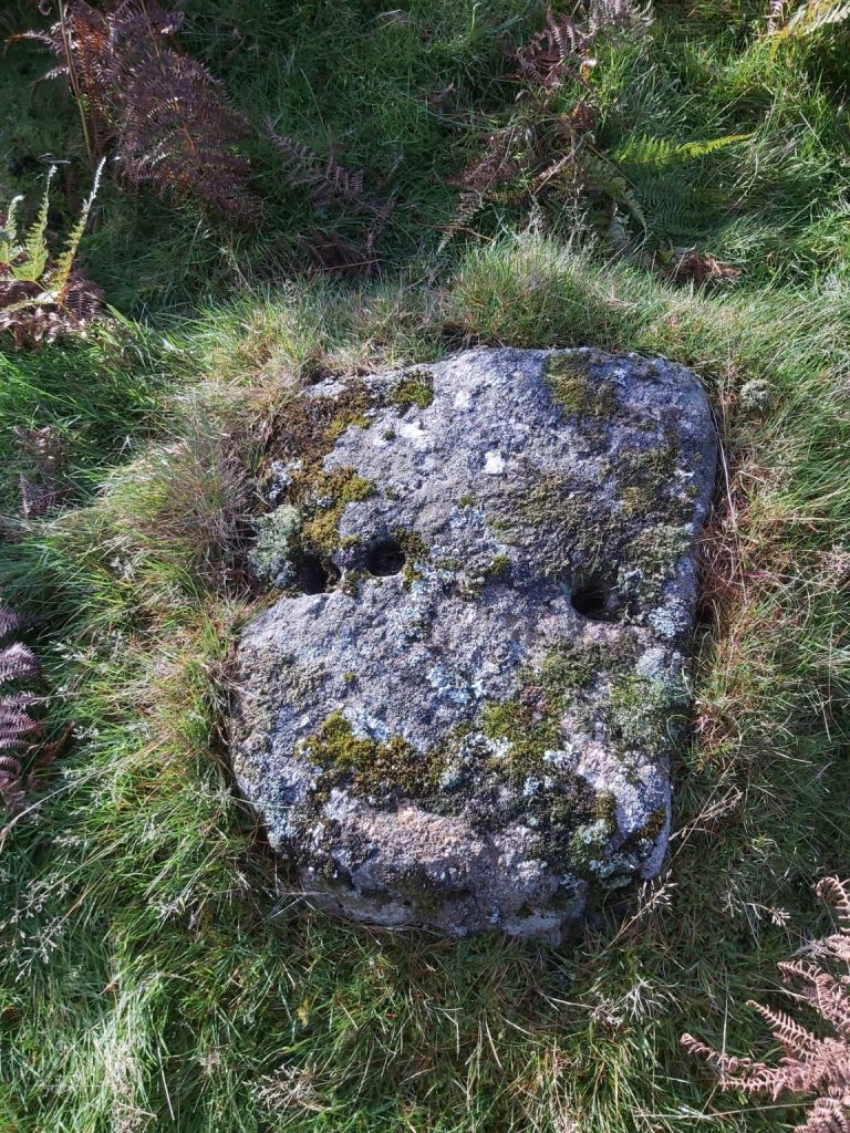
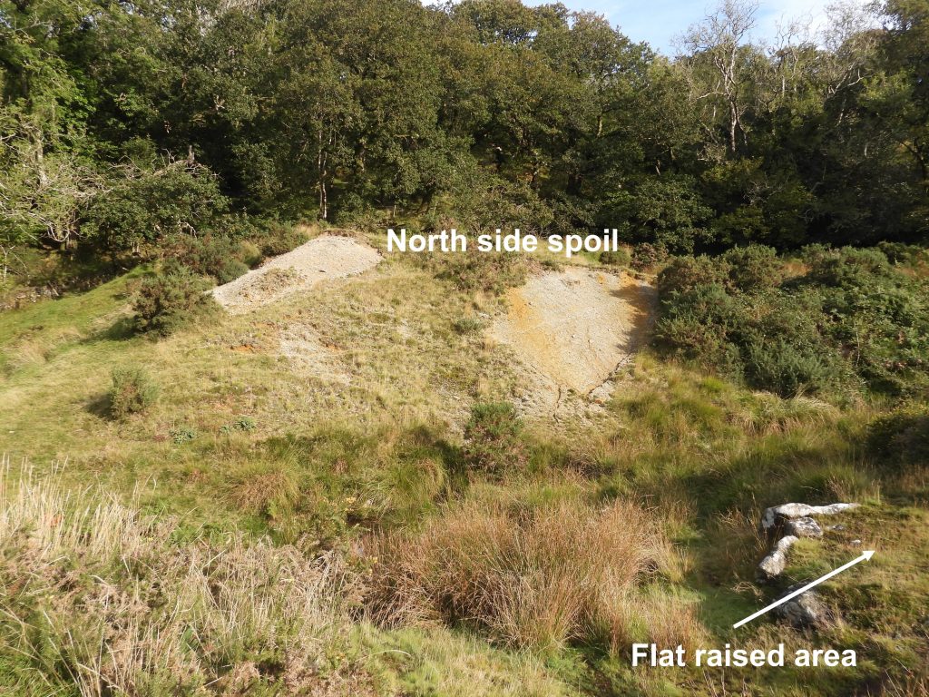
1st November 1847: A licence was granted by Prince of Wales to two Tavistock men to quarry granite. The licence was described as “within a portion of the Commons of Devon, north and south of the road leading from Tavistock to Merrivale Bridge. The northern part of this sett is shown in the sketch map from Wedlake enclosures to the Walkham.1st November 1847: A licence was granted by Prince of Wales to two Tavistock men to quarry granite. The pictures are Peter Tavy Granite 1 stone engraved “PTG1”, which was recumbent until the late 1980’s. This stone marks part of the northern boundary of a sett which relates to a licence granted by Duchy of Cornwall for the two Tavistock men to take granite from within the commons. The two men were Joseph Edgcumbe, a chemist and druggist and John White, a wine and spirit merchant. This stone can be located at SX54726 78057.1st November 1847: A licence was granted by Prince of Wales to two Tavistock men to quarry granite. Probable PTG2, which marks the northern boundary of the aforementioned sett from 1847. A full description of this rock is given in the second edition of Dave Brewer Dartmoor Boundary Markers book, as follows: “6’ earth fast boulder, split naturally, with the letters “PT” on the side of the larger piece, the former well formed but the latter more poorly executed due to the nature of the rock together with what appears to be “TO” on the side nearest the river”. This naturally split rock can be found at SX55554 77687.1st November 1847: A licence was granted by Prince of Wales to two Tavistock men to quarry granite. Walkham Hanging Stone can be located at SX55595 77663. The northern boundary of the sett licenced to Edgcumbe and White was described as a “straight line from a post marked “PTG1” placed by the boundary of the commons at or near Wedlake (Peter Tavy) to a stone post marked “PTG2″ on the west bank of the Walkham at or near Hanging Rock”.2nd November 1850: The first convict prisoners, 95 in total, arrived at Princetown prison. Source: DNP The Dartmoor Diary 1991. The inscription above the gateway is taken from Virgil’s Aeneid and reads “Parcere Subiectis” which translates Spare the Vanquished.3rd November 1934: The body of who is believed to have been Walton Howard from Warrington was found at Rowter Marsh. The body was found by Jack Bailey of Higher Merripit Farm. The body was badly decomposed having been there for around 10 weeks. Source of information for this story: Bodies on the moor by Trevor James.3rd November 1934: The body of who is believed to have been Walton Howard from Warrington was found at Rowter Marsh. Walton’s body was only identified by the possessions found which included a wristwatch, manicure set and a leather workers’ knife (Howard worked in the tannery business). That said, there was doubt (and there still is to this day) whether it was Walton Howard as the hair colour wasn’t as expected, nor the age (estimated vs. Howard’s actual age) and the deceased had a beard, whereas Howard didn’t. The picture is from the south east of Rowter Marsh looking towards Broad Down.3rd November 1934: The body of who is believed to have been Walton Howard from Warrington was found at Rowter Marsh. Howard was last seen on 25th August, leaving work carrying a suitcase. He had mysteriously withdrawn £10 from his bank account (a lot of money in those days), which possibly alluded to the fact he had intended to travel ? The pictures show how desolate Rowter Marsh is looking north towards Braddon Tor (aka Hoax Tor amongst other) and Broad Down3rd November 1934: The body of who is believed to have been Walton Howard from Warrington was found at Rowter Marsh. Howard was initially buried in Postbridge, before being exhumed (after a resumed inquest in January 1935) and taken to Warrington cemetery for reinterment. The mystery surrounding this story still remains.4th November 1862: Eden Phillpotts the writer, poet and dramatist and president of the Dartmoor Preservation Association was born. He was born in Mount Abu, India, was educated in Plymouth, Devon, and worked as an insurance officer for 10 years before studying for the stage and eventually becoming a writer. Phillpotts wrote a great many books with a Dartmoor setting.4th November 1862: Eden Phillpotts the writer, poet and dramatist and president of the Dartmoor Preservation Association was born. One of his novels, Widecombe Fair, was inspired by the annual fair at Widecombe-in-the-Moor and provided the scenario for his comic play The Farmer’s Wife (1916). It went on to become a 1928 silent film of the same name, directed by Alfred Hitchcock.4th November 1862: Eden Phillpotts the writer, poet and dramatist and president of the Dartmoor Preservation Association was born. The picture is of Watchet Hill Cottage (aka the Black House), which was last occupied in 1960’s. It is approx 120 years old. Eden Phillpotts stayed here and it was one of the main locations in his novel, The Secret Woman, which was published in 1905.4th November 1862: Eden Phillpotts the writer, poet and dramatist and president of the Dartmoor Preservation Association was born. Phillpotts spent most of his adult life in Devon, and was a close friend of Agatha Christie, who claimed to be influenced by Eden in her early years as a writer. Source: Devon Persepectives website. Phillpotts “Children of the Mist”, was one of his 20 volume Dartmoor Cycle of 18 novels and two volumes of short stories and evokes the dramatic moorland landscape unfolding from Steeperton Tor.4th November 1719: John Williams leases to Lewis Jutsham one of the Piles Newtakes near Harford. It was described as “All that one large close of land and pasture with thapputenance called or commonly known by the name of Higher Old Pyles sometimes parcell of One tenement Barton of ffarm comonly called by the name Old Pyles”. (Ref: Mike Brown Dartmoor 2001). It is assumed that the tenement was one of the three marked on modern OS maps as ‘farmstead’.4th November 1719: John Williams leases to Lewis Jutsham one of the Piles Newtakes near Harford. Picture is looking down at Longhouse A, the yard (between Longhouse A and Longhouse B) and small rectangular building from the east. The dome of Stalldown Barrow is in the distance5th November 1954: Three stone alignments, ten cairns, three stone hut circles and a length of the Great Western Reave on Longash Common were first registered on Historic England database. The “monument” is as shown on the above map. 5th November 1954: Three stone alignments, ten cairns, three stone hut circles and a length of the Great Western Reave on Longash Common were first registered on Historic England database. The “monument” has two stone alignments. The northern alignment is orientated approximately east to west and includes a 182m long, double row of upright stones, A second double stone alignment lies 24m south of this alignment and runs roughly parallel with it. This alignment includes a 264m long double row of upright stones. More information can be found at: https://historicengland.org.uk/listing/the-list/list-entry/10134295th November 1954: Three stone alignments, ten cairns, three stone hut circles and a length of the Great Western Reave on Longash Common were first registered on Historic England database. The picture shows a large stone cist forming a rectangular pit. The Historic England database states that: “It measures 2.2m long, 0.9m wide and 0.8m deep. It is aligned south east to north west and partly covered by a large granite coverstone, which has been split into two parts. In 1895, the cist was investigated by the Dartmoor Exploration Committee who found a flint scraper, a flint flake and a polishing stone. According to Worth the cist was too generously restored, and he clearly believed that it was originally smaller”. 6th November 1972: Sanders longhouse at Lettaford was listed by English Heritage on this date. The 1873-1888 map shows the hamlet being named as Liddaford. The three longhouses around which the farmsteads of Higher Lettaford, Southmeads and Sanders are annotated above as is the school (Bible Christian Chapel) and the Mariner’s Way. Post of Lettaford can be found here: https://dartmoorexplorations.co.uk/lettaford-hamlet/6th November 1972: Sanders longhouse at Lettaford was listed by English Heritage on this date. The picture shows Sanders Farmstead Longhouse (now owned by Landmark Trust and rented out as a holiday let). Also in the picture on the left, partially obscured by the tree is Southmeads Farmstead Longhouse and the Pig Houses.6th November 1972: Sanders longhouse at Lettaford was listed by English Heritage on this date. Another view of the Sanders Farmstead Longhouse. Also in the picture, the gable end of the old Linhay can just be seen. The Longhouse is recorded as being early 16th century with mid 16th and 17th century modifications. The walls partly granite ashlar, partly granite rubble. The Landmark Trust renovated the Longhouse in 1977. The Linhay is recorded as having been built in the late 18th or early 19th century.7th November 1796: Walter Radcliffe of Warleigh leased Yellowmead farm to Thomas Rice of Wilsworthy Hamlet, Peter Tavy, at an annual rent of £5. The ruins of this farm lie very close to the route of the Lych Path (or Way) which runs from Lydford to Widecombe, therefore is is possible that there may have been a farmstead here since medieval times. 7th November 1796: Walter Radcliffe of Warleigh leased Yellowmead farm to Thomas Rice of Wilsworthy Hamlet, Peter Tavy, at an annual rent of £5. The farm may have once been called “Old Meade” at one time as the prefix of “Yellow” in Dartmoor placenames can sometimes be derived from the word “Old”. Two of the most striking features noted when first approaching the farm are the lane or “drangway” and Field 1090 (see map), which was the garden.7th November 1796: Walter Radcliffe of Warleigh leased Yellowmead farm to Thomas Rice of Wilsworthy Hamlet, Peter Tavy, at an annual rent of £5. To the north east of the lane, the foundations of a dwelling can be made out (as per the location shown on the map). Stone from this building was taken for use on other sites. 7th November 1796: Walter Radcliffe of Warleigh leased Yellowmead farm to Thomas Rice of Wilsworthy Hamlet, Peter Tavy, at an annual rent of £5. The field is recorded as being “internally approx 21m x 12m and bordered by hedgebanks mostly about 1m in height but reaching 1.5m at the lower end.” The westernmost of the two posts has the remains of iron hangings on its N side and the eastern most gate post has an iron plug set in the chamfer.” Source: an archaeological and historical survey conducted by Dr Tom Greeves in 2008, which covers the period from 1672 to 1904.7th November 1796: Walter Radcliffe of Warleigh leased Yellowmead farm to Thomas Rice of Wilsworthy Hamlet, Peter Tavy, at an annual rent of £5. This is the most conspicuous building remains on site at SX53040 8275. It is a stony mound (and is approx. 10m x 8m and around 0.8m max. height).7th November 1873: Richard Andrews and William Smerdon are each paid 3s 8d (about 18p) for two days work “in Awsewell taking down larch for Capt. Browning”. (ref: Dartmoor 2001 – By Mike Brown). It is thought ‘Capt. Browning’ refers to Captain Richard Browning who managed East Birch Tor Mine (near Headland Warren Farm).The picture is from on top of Auswell Rocks looking towards Buckland Beacon7th November 1873: Richard Andrews and William Smerdon are each paid 3s 8d (about 18p) for two days work “in Awsewell taking down larch for Capt. Browning”. The picture is from on top of Auswell Rocks looking north west 7th November 1873: Richard Andrews and William Smerdon are each paid 3s 8d (about 18p) for two days work “in Awsewell taking down larch for Capt. Browning”. Nice to see this young deer in the woods7th November 1873: Richard Andrews and William Smerdon are each paid 3s 8d (about 18p) for two days work “in Awsewell taking down larch for Capt. Browning”. The view is the Double Dart near Lover’s Leap7th November 1835: An advert in the Mining Journal called for applications “from parties desirous of setts, to search for tin and other metals, within lands belonging to Duchy of Cornwall”. The advert stated that attendance will be given on 9th, 10th and 11th November, next at the Duchy Hotel at Prince’s Town7th November 1835: An advert in the Mining Journal called for applications “from parties desirous of setts, to search for tin and other metals, within lands belonging to Duchy of Cornwall”. The photograph of the Duchy Hotel is from c1900, before alterations which were undertaken in 1908-9. Originally the building was used to house the officers from the Napoleonic prison militia. The first landlord was William Stocker in 1810. 7th November 1835: An advert in the Mining Journal called for applications “from parties desirous of setts, to search for tin and other metals, within lands belonging to Duchy of Cornwall”. It is possible that three men from Tavistock Henry Prenton, Francis Prout and John White responded to this advert as, in 1836 a licence was granted to them to run for twelve months at the cost of 1/18 share or dues for Knack Mine in the Upper Taw Valley. The bounds of the mine were set as being: “From a certain rock or stone marked WV on the eastern side of the shaft known by the name of Wheal Virgin Shaft to the length of three hundred fathoms eastward and four hundred fathoms westward, being together seven hundred fathoms on the course of the lode on which the said shaft is now sinking and one hundred and fifty fathoms north and south thereof…” The picture shows the Wheal Virgin (WV) stone7th November 1835: An advert in the Mining Journal called for applications “from parties desirous of setts, to search for tin and other metals, within lands belonging to Duchy of Cornwall”. If this story relates to the three men from Tavistock (Henry Prenton, Francis Prout and John White) in 1836, they would have been familiar with the scene shown in the photograph. As with most Dartmoor mines the site at Knack Mine first aroused interest due to the Medieval openworks dug by the ‘old men’. On the western valley slopes of the upper River Taw there is evidence of tin lodes worked from surface sometime around the 16th century. Working of these openworks at depth probably started in the late 18th century. Indeed Duchy records in 1799 show the mine was known as Wheal Virgin and was owned by Gill & Co. The ‘Halcyon’ days of the mine did not arrive until 1878, when one ton of black tin was sold and 27 men were employed.8th November 1984: The 3d orientation table at Barn Hill / Pork Hill Car Park was unveiled by His Royal Highness, the Duke of Cornwall / Prince of Wales. This well known feature is located at the western end of the car park overlooking the valley towards Tavistock and beyond.8th November 1984: The 3d orientation table at Barn Hill / Pork Hill Car Park was unveiled by His Royal Highness, the Duke of Cornwall / Prince of Wales. This Orientation Table has a 3D representation of the topography in front of it.8th November 1984: The 3d orientation table at Barn Hill / Pork Hill Car Park was unveiled by His Royal Highness, the Duke of Cornwall / Prince of Wales. The 3d topography interpretation is shown in the picture.8th November 1984: The 3d orientation table at Barn Hill / Pork Hill Car Park was unveiled by His Royal Highness the Duke of Cornwall / Prince of Wales. The table gives the distances of 20 places which can be seen and 1 not seen from this viewpoint. The places are: Staddon Hts, Plymouth Hoe, Mt. Edgecumbe Pk, Roborough Down, Plaster Down, Tamar Bridge, Saltash, Whitchurch Common, Tavy Valley, Whithcurch Down, Lands End (obviously not in view), Gunnislake, Tamar Valley, Kit Hill, Caradon Hill, Kilmar Tor, Tavistock, Brown Willy, Launceston, Ramsdown and Brent Tor.8th November 1984: The 3d orientation table at Barn Hill / Pork Hill Car Park was unveiled by His Royal Highness, the Duke of Cornwall / Prince of Wales. The inscription below the 3d topography interpretation states: “Erected by the Royal Town Planning Institute to commemorate the 70th anniversary of the Institute and to contribute to the enjoyment of the countryside”.8th November 1984: The 3d orientation table at Barn Hill / Pork Hill Car Park was unveiled by His Royal Highness the Duke of Cornwall / Prince of Wales. To the front (west side) of the table two more inscriptions can be found. Inscription 1 states: “Erected by the Royal Town Planning Institute with assistance from the Countryside Commission, Dartmoor National Park, the Manpower Services Commission and the co-operation of the Duchy of Cornwall and the Whitchurch Commoners. Base stone and paving from Merryvale (sic) Quarry donated by Tarmac Quarry Productes, sculptor Brian Rothnie (Access) Bristol. Inscription 2 states: “Unveiled by His Royal Highness the Duke of Cornwall 8th November 1984”. Note the spelling error on inscription 1, which should of course read Merrivale (not Merryvale).8th November 1984: The 3d orientation table at Barn Hill / Pork Hill Car Park was unveiled by His Royal Highness the Duke of Cornwall / Prince of Wales. The picture shows the close up of Inscription 2 from the previous photograph with the unveiling information.9th November 2015: Round barrow north of Cadworthy Wood record on Historic England database was last updated. The record is 1002552 and part of the records states: “This monument includes a kerbed cairn with cist situated within a coaxial field system on the south eastern side of Wigford Down, overlooking the Plym Valley. The kerbed cairn survives as a circular stony mound measuring up to 8.23m in diameter and 0.8m high. A retaining kerb is visible to the south as a 0.6m high arc of large stones with an internal diameter of approximately 7m”. 9th November 2015: Round barrow north of Cadworthy Wood record on Historic England database was last updated. The record reveals that: “The cairn had been subject to an earlier excavation but was re-examined by Worth in 1900 and two fragments of late Bronze Age pottery were recovered”.9th November 2015: Round barrow north of Cadworthy Wood record on Historic England database was last updated. The record further states: “The central cist is also visible, as a stone lined rectangular feature partly obscured by the displaced coverstone. It measures up to 1.1m long by 0.8m wide and 0.7m deep”. 10th November 1964: White Barrow round cairn was first recorded on the Historic England database. The entry reference is 1007896. White Barrow is accepted by Permabulators as part of the modern boundary. It is nothing more than a low grassy mound with a few stones and could easily be missed (in the mist!).10th November 1964: White Barrow round cairn was first recorded on the Historic England database. The picture shows a view (North) from White Barrow, showing the line of the Lych Path / Way, can be seen. The Lych Path is a medieval track along which the dead were taken from the early settlements from the eastern part of the moor to Lydford Church. The Historic England database describes the cairn as mound measuring 19.7m in diameter and standing up to 1.4m high on the north side and 0.7m high on the south. 10th November 1964: White Barrow round cairn was first recorded on the Historic England database. This picture is of White Barrow looking east. The Lych Path descends to the River Walkham valley from this point. The Historic England description further states the barrow has “a shallow hollow in the centre of the mound suggests partial early excavation or robbing. The outer edges of the mound survive as a buried feature below deep peat deposits”.11th November 1950: Richard Hansford Worth passed away on this date. He was born on 5th November 1868 in Plymouth and was a civil engineer, geologist, archaeologist and writer on Dartmoor. He was the author of numerous papers published by the Devonshire Association and the Plymouth Institution. Some 37 of these papers became the basis of the book Worth’s Dartmoor published posthumously.11th November 1950: Richard Hansford Worth passed away on this date. He is pictured here alongside his wife (centre) at the opening of the Redlake Tramway on 11th September 1911. He was the Engineer employed on the project for the clay pipeline and the construction of the tramway. The 8 miles 17 chains tramway took only a year or so to build with Richard Hansford-Worth having surveyed the route in 1909. 11th November 1950: Richard Hansford Worth passed away on this date. On page 31 of “Worth’s Dartmoor” is a sketch of Gutter Tor Rock Basin and on the page facing page 95 is a photograph of same. The section of the book is called “Physical Geography”. The authors photograph was taken in January 2020.11th November 1950: Richard Hansford Worth passed away on this date. On page 297 of “Worth’s Dartmoor” is a sketch of Hook Lake Blowing House. The author has a post on this blowing house (which makes reference to Worth) and can be found at : https://dartmoorexplorations.co.uk/hook-lake-tinners-mill/11th November 1950: Richard Hansford Worth passed away on this date. In “Worth’s Dartmoor” under the Physical Geography section are two tors, Chat Tor (left) and Thornworthy Tor (right). Worth noted the Lamellar bedding with rare but well marked joints of Chat Tot and the rounded block of Thornworthy Tor.11th November 1950: Richard Hansford Worth passed away on this date. In “Worth’s Dartmoor”, reference is made to Thornworthy Kistvaen and the Hanging Stone on Lee Moor. The Hanging Stone is inscribed with “C B” and it is suggested (not by Worth though) that this stone might relate to Cholwich with possibly it being part of the bounds of an original clay sett.11th November 1825: A 21 year lease was granted to John Collier for the Fillace Down Mining Sett. This was a small Copper Mine, which over its lifetime was also known as Walkhampton Consols and Wheal Rose, which was last worked in about 1860. Remains of the mine are north of the Walkhampton to Horrabridge road and parts of the leat which formerly brought water from the brook just below Knowle Farm, are still traceable. Helen Harris (1968), in her book Industrial Archaeology of Dartmoor, records about the mine: “There are overgrown dumps and a pit about 3.0 metres deep, also two stone walls above the river bank which probably formed part of a wheelpit”.11th November 1825: A 21 year lease was granted to John Collier for the Fillace Down Mining Sett. The north-eastern extent of the mine sett appears to have been marked by a row of three stones, which are depicted on 19th Century OS maps. There are only two extant stones today. The stone marked the divide between Fillace Down and Knowle Down and are inscribed appropriately ‘FD / KD’. The stones are located at SX52490 69847 and SX52510 6980611th November 1825: A 21 year lease was granted to John Collier for the Fillace Down Mining Sett. Northeast boundary of the sett is marked by a wide ‘reave’ or wall. The photograph is of the ‘reave’ is looking south where stone 3 is believed (using side-by-side maps as a guide) to have been located at SX52520 69748.11th November 1825: A 21 year lease was granted to John Collier for the Fillace Down Mining Sett. Of interest near the southern boundary of the sett is a boundary stone inscribed ‘HCC 1867 No 5’. It is one of eight such stones which marked the bounds of the ‘Horrabridge Consolidated Chapelry’. These bounds later became those of the civil parish. The stone would have been erected 7 years after the mine closed.12th November 1930: Golden Dagger, the last tin mine on Dartmoor closed. Source DNP – The Dartmoor Diary 1991. The picture is of the Miners Dry at SX68291 80327, which was where miners clothes were dried.12th November 1930: Golden Dagger, the last tin mine on Dartmoor closed. Adit level mine entrance at SX68219 80364.12th November 1930: Golden Dagger, the last tin mine on Dartmoor closed. Picture is the Stamps Wheel Pit / Wheel House.12th November 1930: Golden Dagger, the last tin mine on Dartmoor closed. Buddle at lower end of the Redwater valley.12th November 1930: Golden Dagger, the last tin mine on Dartmoor closed. Ruins of the Engine House from 1920’s at SX68545 79883.12th November 1930: Golden Dagger, the last tin mine on Dartmoor closed. Dinah’s House at SX68465 80048 comprised 5 rooms. Two bedrooms, a lounge, a kitchen and a store room12th November 1930: Golden Dagger, the last tin mine on Dartmoor closed. The picture is of the pre-1920’s dressing floor, which can be found at SX68410 80151.12th November 1993: ‘Jail Ale’ and ‘Prince of Ales’ were launched by the Dartmoor Brewery.12th November 1993: ‘Jail Ale’ and ‘Prince of Ales’ were launched by the Dartmoor Brewery. The launch took place in the Prince of Wales pub in Princetown.13th November 1892: The shocking tragedy of a double murder at Peter Tavy. The incident took place at Creedy Lane near Cox Tor Farm. The police found 17 year old Emma Doidge dead at the scene from a single gun shot and her 22 year old companion William Rowe lying a few yards away close to death himself, caused by a similar wound. William Rowe died the following day at home. Their assailant was William Williams, the 19 year old son of the miller from Peter Tavy.13th November 1892: The shocking tragedy of a double murder at Peter Tavy. It was a Sunday and Emma Doidge was being walked home to Cox Tor Farm by William Rowe following a church service where Emma had sung in the choir and William was blowing (or pumping) the organ for his father Joseph who was the resident organist. William Williams harboured an infatuation for Emma and ambushed them on that fateful evening. He previously purchased a revolver in Tavistock 5 days earlier.13th November 1892: The shocking tragedy of a double murder at Peter Tavy. Cox Tor Farm was where Emma lived. Williams had written to her in the weeks leading to the incident, but she had spurned his advances and sent him a short note saying that she could only see him as a brother. From this, Williams became jealous especially towards William Rowe who lived in Lucy Cottage in Peter Tavy not far from where he lived himself at the village (higher) mill.13th November 1892: The shocking tragedy of a double murder at Peter Tavy. In the lane leading to Cox Tor Farm is a Latin cross head (with one arm missing) which is known as either Cox Tor Farm Cross or Headlands Cross (being between the two properties of these names). The cross is believed to be medieval in origin being roughly dressed granite. It has an iron rod set in the back which suggests it has been used as a gate-post and may not be in its original position. Interestingly, this cross does not appear on any 19th century maps (to the authors knowledge) but does on 20th century maps. It may be purely co-incidental, however, the author has always thought the placing of this cross in the bank of the hedge may well be related to the tragedy.13th November 1892: The shocking tragedy of a double murder at Peter Tavy. The picture shows Lucy Cottage in Peter Tavy, the former home of William Rowe.13th November 1892: The shocking tragedy of a double murder at Peter Tavy. The picture shows Higher Mill in Peter Tavy, the former home of William Williams.13th November 1892: The shocking tragedy of a double murder at Peter Tavy. Peter Tavy Inn was where the inquest was opened and adjourned on Tuesday 15th November 1892.13th November 1892: The shocking tragedy of a double murder at Peter Tavy. The inquest was concluded at the village school on Saturday 19th November 1892, two days after the double funeral took place for Emma Doidge and William Rowe at St. Peter’s Church. The school opened in 1865 and was used until 1959. It is now the village hall. William Williamson was found guilty of his crimes and executed in March 1893.14th November 1802: George Routleigh (the watchmaker) passed away on this date. He had lived in Launceston but his tomb can be found just outside the porch of St. Petroc’s Church Lydford. It is believed that when his health started to decline he moved in with his brother (Edward), who was a local churchwarden and who was living in the parsonage house. Source: Legendary Dartmoor14th November 1802: George Routleigh (the watchmaker) passed away on this date. The lid stone of his tomb has been removed from outside and now resides on a wall inside the church and is lit by a spotlight. This was to prevent further weathering of the epitaph inscribed on it. The epitaph is rather amusing and was originally thought that George had written it some years before his death. The words have been found to have been published in an American almanac in 1797, being the work of a black American astronomer called Benjamin Banneker who was also a clockmaker. However, in more recent years, an even earlier version has been discovered as having been printed in the Derby Mercury in 1786. Source: Devon Heritage. The epitaph reads:
Here lies in horizontal position The outside case of George Routleigh, Watchmaker Whose abilities in that line were an honour To his profession Integrity was his mainspring, And prudence the regulator Of all the actions of his life. Humane, generous and liberal His hand never stopped Till he had relieved distress. So nicely regulated were all his motions That he never went wrong Except when set agoing By people Who did not know His key. Even then he was easily Set right again. He had the art of disposing his time So well That his hours glided away In one continual round Of pleasure and delight Till an unlucky minute put a period to His existence. He departed this life Nov. 14th 1802 Aged 57 Wound up In the hopes of being By his Maker And of being thoroughly cleaned, repaired And set agoing In the world to come.
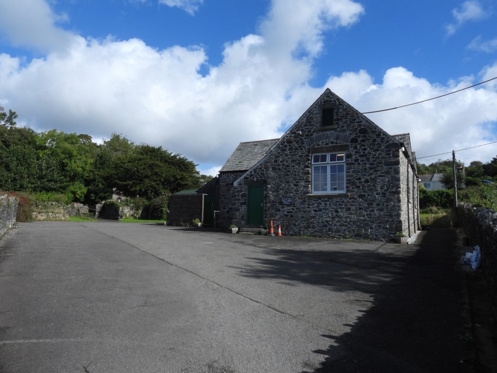
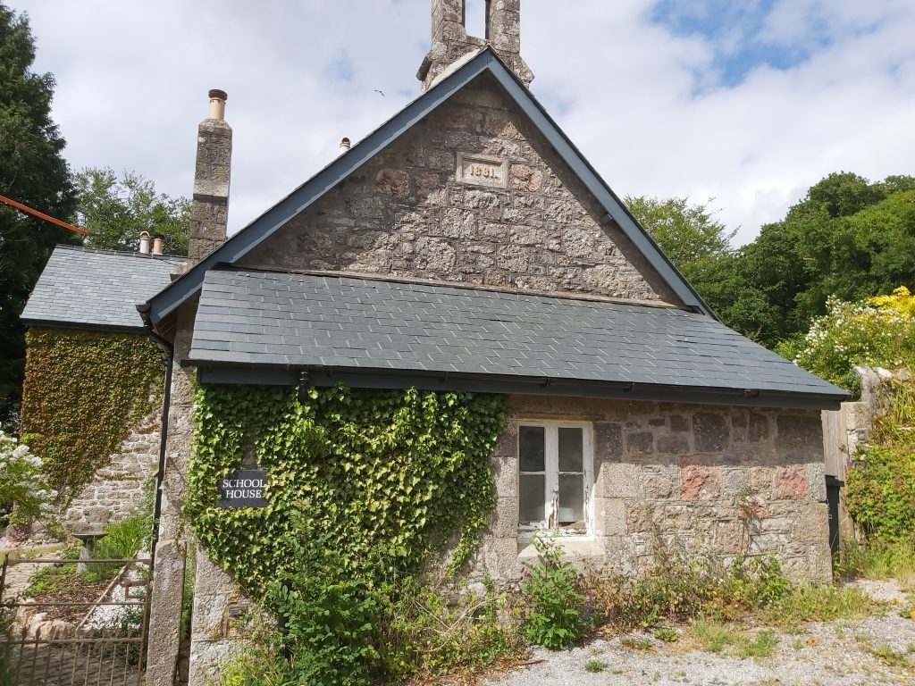
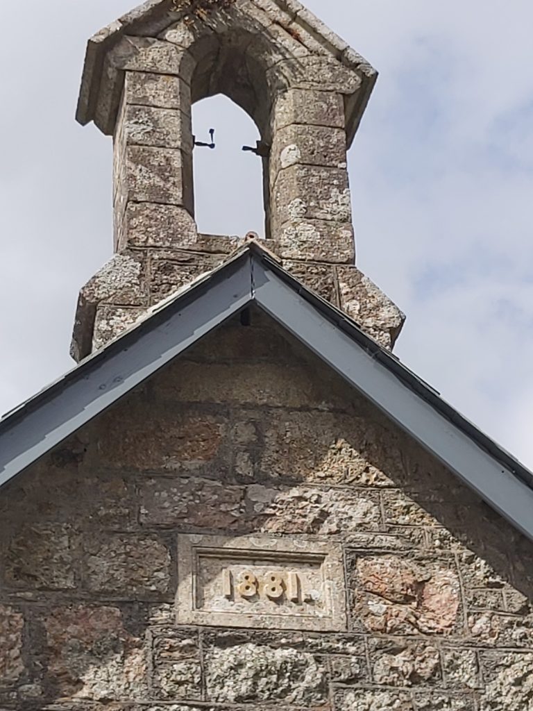
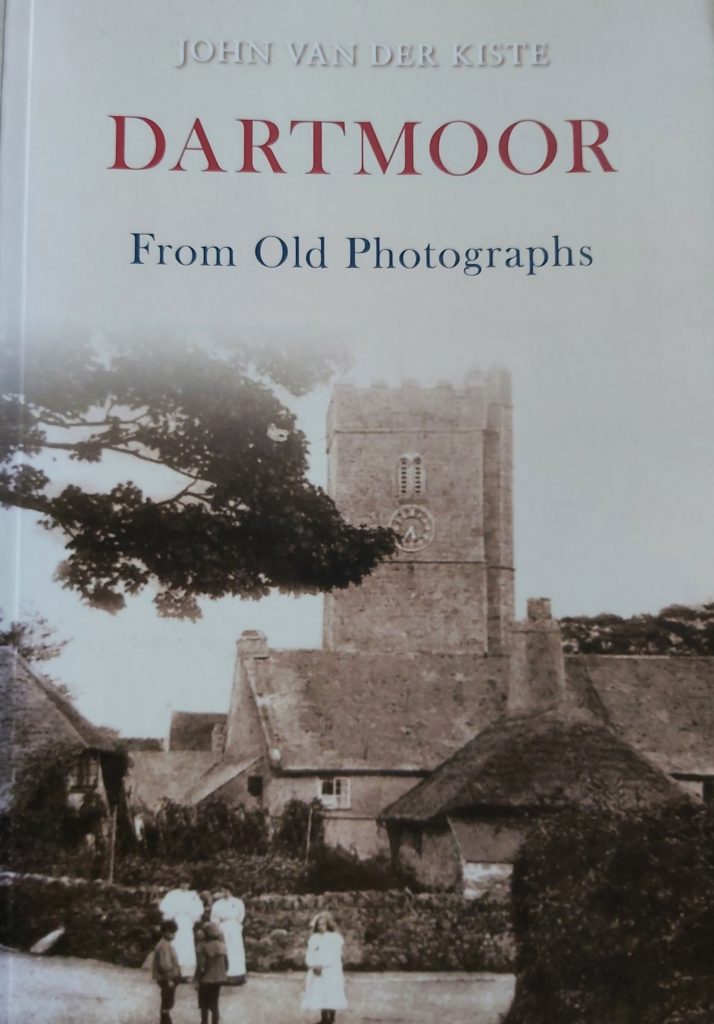
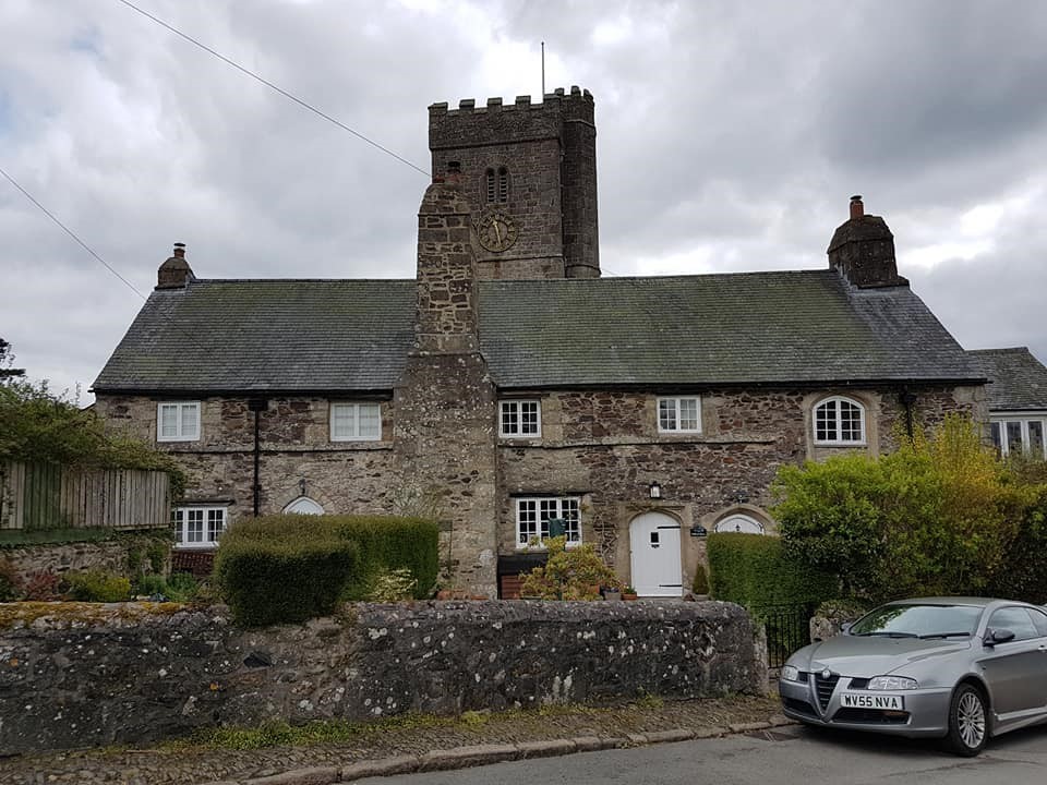
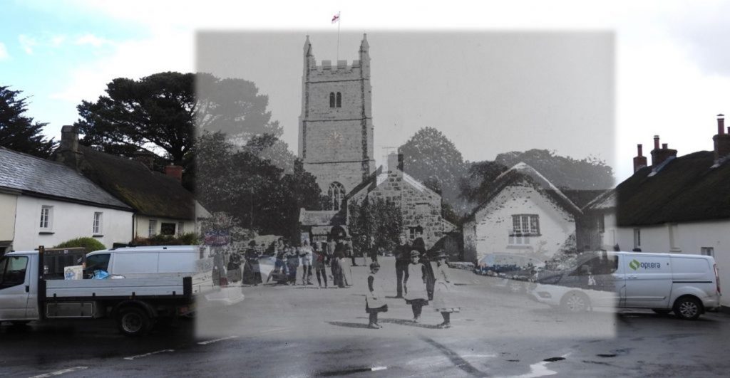
15th November 1918: At Harford School, an extract from the logbook on this date states: “On hearing the Armistice had been signed Monday 11th, stopped lessons and sang the National Anthem at a quarter past three”. (ref: Dartmoor 2001 – Mike Brown). Was this an indication of how slowly news (even on National and International importance) filtered through to some secluded hamlets? The school house was built on the site of an old cottage in 1881 (see date plaque in picture), along with accommodation for the school mistress. The schoolhouse was used from 1881 to 1920, when pupils were moved to Ivybridge. 15th November 1918: At Harford School, an extract from the logbook on this date states: “On hearing the Armistice had been signed Monday 11th, stopped lessons and sang the National Anthem at a quarter past three”. Of interest, is that an entry in the Cornwood school logbook records for Monday 11th November that: “Shortly after assembly I heard the sirens and hooters of Plymouth sounding…I anticipated that they signalled the acceptance by Germany….for an Armistice”. Did Harford only hear about the Armistice 4 days after Cornwood in spite of their proximity to each other ?15th November 2010: “DARTMOOR From Old Photographs” by John Van der Kiste was published. The book has 128 pages of black and white photographs and postcards in six sections; 1. Views ; 2. Tors, Crosses and Hut Circles ; 3. Churches, Schools, Houses and Farms ; 4. Towns, Villages and Hamlets ; 5. Railways and Transport ; 6. People and Military plus Acknowledgements. Source: Date found on two sources, Amazon and Blackwell.co.uk.15th November 2010: “DARTMOOR From Old Photographs” by John Van der Kiste was published. The front cover of the book shows a view of St. Michael’s Church, Ilsington, from c1900. This photograph shows a view of Ilsington taken in 2018. The row of 3 cottages in front of the church were formerly the Church House dating from early 16th century. They were restored in 1938. The Church is late 13th or early 14th century and was enlarged and partly rebuilt in 15th or early 16th century. 15th November 2010: “DARTMOOR From Old Photographs” by John Van der Kiste was published. The picture(s) are Drewsteignton in 1889 overlaid with a 2021 view. This view (aside tarmac and modern vehicles) has changed very little. The delightful Holy Trinity church stands like a sentinel overlooking the village scene. There is a subtle change to the Holy Trinity Church from the 1889 view. insofar as there is now a clock face showing. The original (faceless) clock was removed from the church tower in 1892, when the present movement was installed. It had been made by an unknown local craftsman c.1670-1700. It had neither a face nor hands but struck the hours on the tower bell. It is now in the back of the nave. Source : Heritage Gateway.15th November 2010: “DARTMOOR From Old Photographs” by John Van der Kiste was published. The old postcard of the Plume of Feathers, Princetown (for which the author already had a copy) is in the book p78 and is thought to date from c1907. The Jubilee lamp dates from 1887. Plume of Feathers was built in 1785. The author can just about remember the small gift shop at the front / left of the building. 16th November 1802: Sourton (Parish) buried the body of a stranger found dead on moor, which although unremarkable in its own right is nevertheless intriguing as it was essentially a lesson learnt where previously they have refused the very same and consequentially rescinded part of their land to Okehampton. Source: Mike Brown’s Guide to Dartmoor CD. The picture is St. Thomas a Becket Church in Sourton village, which is assumed where the burial took place. After a Coroners Inquest, it was stated that the stranger appeared to be about 44 years of age and from items found in his pocket and upon enquiry he was confirmed to be Benjamin Hardridge late of Broadstreet Point, Portsmouth, Hants16th November 1802: Sourton (Parish) buried the body of a stranger found dead on moor which although unremarkable in its own right was essentially a lesson learnt where previously they have refused the very same and consequentially rescinded part of their land to Okehampton. The story can be explained as follows: At the southern end of a boundary ditch / reave at the head of Deep Valley stands a boundstone (called “Spring Rock”). It appears to be inscribed ‘B/So’, on its two faces. The stone and ditch mark the boundary between Bridestowe and Sourton Commons, the land to the east shared by both parishes, that to the west being the preserve of Sourton only. North of this point, the area of land encompassed by the ditch and the modern parish boundary line is known as The Triangle. It was this area which was rescinded to Okehampton parish following a boundary dispute, as a result Sourton refusing to bury the body of a previous stranger found dead on the moor.16th November 1802: Sourton (Parish) buried the body of a stranger found dead on moor which although unremarkable in its own right was essentially a lesson learnt where previously they have refused the very same and consequentially rescinded part of their land to Okehampton. From the description of the dispute, the land known as the Triangle has been assumed as that shown in the above map. The date of the land dispute appears to be open to conjecture, for it was not recorded by any of Dartmoor’s early writers.16th November 1802: Sourton (Parish) buried the body of a stranger found dead on moor which although unremarkable in its own right was essentially a lesson learnt where previously they have refused the very same and consequentially rescinded part of their land to Okehampton. The body of the first stranger found dead on the Moor was at, or near, Iron Gates. That said, the exact location of Iron Gates, or Iron Catch Gate, a former bondmark of the parishes, is disputed, although Boundary Stone called Spring Rock was known as “Iron Gate” by William Crossing.17th November 2010: A Dartmoor Society Research Lecture was held with Lauren Parry giving a talk on ‘the sustainable carbon smanagement of British blanket peatlands: a case study on Dartmoor’. As part of her research, Lauren chose three sites to monitor. One of the sites was Maiden Hill (between the headwaters of the Walkham and Cowsic rivers). This was ‘control’ site, seemingly unaffected by digging or burning. The picture is on the north side of Maiden Hill near Spriddle Lake.17th November 2010: A Dartmoor Society Research Lecture was held with Lauren Parry giving a talk on ‘the sustainable carbon management of British blanket peatlands: a case study on Dartmoor’. Another site chosen to monitor was Blackbrook Head (4 km N of Princetown)– a site with evidence of draining/digging – there are some 30km of dug drainage ditches here within a 100ha area. The author has visited the area and explored the tinners’ hut, mounds and meilers.17th November 2010: A Dartmoor Society Research Lecture was held with Lauren Parry giving a talk on ‘the sustainable carbon management of British blanket peatlands: a case study on Dartmoor’. The picture is the Tinners’ Hut near Black Dunghill17th November 2010: A Dartmoor Society Research Lecture was held with Lauren Parry giving a talk on ‘the sustainable carbon management of British blanket peatlands: a case study on Dartmoor’. The pictures show the two mounds in the Blackbrook Head area. Both look man made.17th November 2010: A Dartmoor Society Research Lecture was held with Lauren Parry giving a talk on ‘the sustainable carbon management of British blanket peatlands: a case study on Dartmoor’. The pictures show 6 Meilers which are the most obvious man made looking in the area. Meilers are man made mounds used in the production of peat charcoal.17th November 2010: A Dartmoor Society Research Lecture was held with Lauren Parry giving a talk on ‘the sustainable carbon management of British blanket peatlands: a case study on Dartmoor’. The third location chosen by Lauren to monitor was Black Hill (1km S of Cranmere Pool) – a site with recent burning. The data (taken from https://www.dartmoorsociety.com/debates/2010_research_lecture) shows an estimate that “Dartmoor contains some 9.7 Mt (1 x megatonne = 106, i.e. 1 million, tonnes) of carbon stored in its peat, which is the approximate equivalent of some two years of emissions by the agricultural industry. Most of this (7.22 Mt) is stored within the blanket peat i.e. 629 tonnes per hectare. The Forest of Dartmoor alone contains some 5.95 Mt (562 tonnes per hectare)”. Fascinating stuff……18th November 1267: Henry III gave Richard, Earl of Cornwall, a market on Wednesdays at his manor of Lydford. He also gave him a fair of three days on the eve, day and morrow of St. Petroc. Recorded on the Heritage Gateway, the stone keep at Lydford castle (pictured) had three main periods; the first of which was a free standing stone building of two or more storeys built in the late 12th century; the second was in the late 13th century, two storeys were added to the original ground floor walls (used as prison accommodation, with different standards of comfort reflected by variations in the room sizes and amenities) ; the third phase was 18th century refurbishment.18th November 1267: Henry III gave Richard, Earl of Cornwall, a market on Wednesdays at his manor of Lydford. The picture is of a Viking Rune stone next to the Keep at Lyford Castle.18th November 1267: Henry III gave Richard, Earl of Cornwall, a market on Wednesdays at his manor of Lydford. Neither Henry or Richard would have dropped in for a pint at the Castle Inn as the building is thought to be 16th or 17th century in date and was first known as the White Horse Inn. It changed its name to the Castle Inn in 1807. 18th November 1267: Henry III gave Richard, Earl of Cornwall, a market on Wednesdays at his manor of Lydford. St Petroc’s Church in Lydford is first mentioned in the 13th century and with earlier church sacked by the Danes in 997. The tower and south aisle were built in the 15th century with the church being restored in the 19th century.19th November 1974: Leapra Cross, a wayside cross at the entrance to Moor Gate Farm was first registered on the Historic England database. The registration number is 1009180. The record states: “……squared head and arms and short length of the shaft of a medieval wayside cross of coarse granite with large feldspar crystals. It is set on top of a hedgebank on the west side of the gateway leading to Moor Gate Farm, about 23m south of the B3212 Moretonhampstead to Princetown road”. 19th November 1974: Leapra Cross, a wayside cross at the entrance to Moor Gate Farm was first registered on the Historic England database. It is also called Leeper Cross and is medieval in origin. It was set up in its present location in 1937 on the insistence of the Dartmoor Preservation Association. However, prior to that at the turn of the 20th century William Crossing had noted the cross at Liapa Farm and wrote about it (Crossings Guide page 263). In his guide he describes “a fine granite cross may be seen built into the garden wall” . Shortly after Crossing’s comments, a Viscount Hambledon had the cross removed and taken to his house at North Bovey. 20th November 1940: A Gloster Gladiator crashed on High Willhays. The Gladiator II N5644 of 247 Sqn took of from St Eval at 2000 hrs to carry out a night patrol east of Plymouth. When the aircraft did not return and was thought to have crashed into the sea. Members of the Home Guard were asked to keep a look out.20th November 1940: A Gloster Gladiator crashed on High Willhays. On 22nd November, the wreckage of the Gladiator was found with sadly inside the body of the pilot, Sgt Thomas. It was presumed that the pilot had made an error of navigation and flown into a hillside at over 2,000 feet with the Gladiator breaking up over a distance of 200 yards. RIP Sgt Thomas.21st November 2003: Ted Birkett Dixon who lead WEA night walks on Dartmoor lead his final walk. The picture is from the last walk and the presentation of a cake at Middleworth Farm, near Norsworthy Bridge. Ted was the recorder for the Dartmoor Preservation Association from the early 1950’s having taken over the role from Richard Hansford-Worth. The author feels very privileged to have known and been guided by Ted.21st November 2003: Ted Birkett Dixon who lead WEA night walks on Dartmoor lead his final walk. The picture is Ted explaining the operation of a buddle at Golden Dagger Mine on 22nd March 2002.21st November 2003: Ted Birkett Dixon who lead WEA night walks on Dartmoor lead his final walk. On 7th November the BBC Spotlight cameras (with Johnny Rutherford) joined a walk from Norsworthy Bridge to Combeshead Tor and back. The two pictures on the left show the BBC cameras interviewing some of the group and Ted. The picture on the right is Ted and the author lighting a sparkler as it was close to bonfire night. The BBC Spotlight feature appeared on two consecutive nights. The video quality isn’t the best but here is part one https://youtu.be/eVooGeZm_4M and here is part two https://youtu.be/vlSoFUcRmhQ The author appears at around 2′ 10s (my 14 seconds of fame !!)21st November 2003: Ted Birkett Dixon who lead WEA night walks on Dartmoor lead his final walk. The picture is Ted at Nun’s (Siwards) Cross from 8th March 2002.21st November 2003: Ted Birkett Dixon who lead WEA night walks on Dartmoor lead his final walk. The picture is Ted en-route between Gutter Tor Car Park and Yellowmead quadruple circle from 11th April 2003.21st November 2003: Ted Birkett Dixon who lead WEA night walks on Dartmoor lead his final walk. The picture is Spurrell’s Cross from 24th October 2003.21st November 2003: Ted Birkett Dixon who lead WEA night walks on Dartmoor lead his final walk. The picture is also from 24th October 2003 taken at Hangershell Rock. Ted is in mid-picture.21st November 2003: Ted Birkett Dixon who lead WEA night walks on Dartmoor lead his final walk. These pictures are from the final walk. Ted was 80 the day after (22nd November). A true gent who lead night walks for around 50 years. We presented him with a framed print of the Wallabrook Clapper by Stephen Townshend. The author has continued night walks (not with WEA) and is known as “Ted’s Apprentice”.21st November 1821: Peter Tavy Church (St. Peters) receives “material injury from a tremendous storm of lightning and thunder”, the results that leave the tower and church “lamentable spectacles of the Judgements of God”, as a contemporary report in the parish register records (ref: Mike Brown – Dartmoor 2001 – A Dartmoor Diary of Yesteryear). St. Peter’s is believed to be of 14th century origin, was much rebuilt in 15th century and restored in the 1870s.21st November 1821: Peter Tavy Church (St. Peters) receives “material injury from a tremendous storm of lightning and thunder”, the results that leave the tower and church “lamentable spectacles of the Judgements of God”, as a contemporary report in the parish register records. Peter Tavy’s cross was re-erected on 11th December 2000 to mark the millennium. The new shaft and cross was made by Messrs Pascoe of Gunnislake with granite being donated by DNPA which was quarried at Merrivale. A special service was held on 1st January and was attended by about 50 people. Carvings on the socket stone include the Cross Keys of St. Peter, a Fish, a frontal view of a Rams head, a Salamander and a Rampant Lion. The cross had been dismantled 150 years earlier as horse drawn hearses needed extra room to turn around outside the church, so the cross was removed. The cross was laid in pieces outside the church wall but the shaft and cross were lost just leaving the socket. A new shaft and cross had to be made.22nd November 1965: A Stone alignment, hut circle settlement, medieval long house and post-medieval farmstead at Assycombe were first registered by Historic England. The registration number is 1017981. The map indicates the extent of the monument.22nd November 1965: A Stone alignment, hut circle settlement, medieval long house and post-medieval farmstead at Assycombe were first registered by Historic England. The entry on the database states: “The stone alignment includes two parallel lines of upright stones leading downslope for 125m from an encircled cairn. The lower end of the alignment is denoted by a blocking stone”. These features are shown in the four pictures.22nd November 1965: A Stone alignment, hut circle settlement, medieval long house and post-medieval farmstead at Assycombe were first registered by Historic England. The entry on the database further states:“Midway along the alignment a length of reave crosses the row and leads towards two stone hut circles situated to the south”. These features are shown in the picture.22nd November 1965: A Stone alignment, hut circle settlement, medieval long house and post-medieval farmstead at Assycombe were first registered by Historic England. The record additionally states: “The post-medieval farmhouse includes a three roomed building with drystone and orthostatic walls standing up to 2m high. Surrounding the farmhouse are at least four yards each defined by low drystone walls and beyond these are several small fields”. This farmstead (Assycombe Farm) is subject of a Dartmoor Explorations post, here: https://dartmoorexplorations.co.uk/fernworthy-forest-farms/22nd November 1965: A Stone alignment, hut circle settlement, medieval long house and post-medieval farmstead at Assycombe were first registered by Historic England. The picture is Assycombe Farm building from the South. This is taken from a similar location to one found on the Dartmoor Archive from 29th May 1894 (Burnard collection). Each of the three rooms had an entrance on the south side, which clearly can be seen from the 1894 picture. The uprights still extant in 2020 can still be made out in the 1894 picture. https://dartmoortrust.org/archive/record/348923rd November 1987: The National Park Authority undertook larch thinnings at Sanduck, utilising heavy horses. Source: DMP Dartmoor Diary 1991.23rd November 1987: The National Park Authority undertook larch thinnings at Sanduck, utilising heavy horses. The horses were used to extract the timber economically from a woodland with difficult access.23rd November 1987: The National Park Authority undertook larch thinnings at Sanduck, utilising heavy horses. The work was undertaken with the assistance of David Underhill from the Totnes based Devonshire Omnibus Company. The picture shows Sanduck Grove Tor.24th November 2000: Vermin trap described as 700m ENE of Trowlesworthy Warren House, forming part of Trowlesworthy Warren was first registered by Historic England. The registration number is 1014612. Historic England describes the vermin trap as being adjacent to the Lee Moor China Clay Works leat and lying on a gentle north west facing slope overlooking the River Plym. 24th November 2000: Vermin trap described as 700m ENE of Trowlesworthy Warren House, forming part of Trowlesworthy Warren was first registered by Historic England. The vermin trap is described as “including two lengths of drystone wall forming a `V’-shaped trap pointing towards the leat. The position of the trap suggests that it was designed to capture vermin using the leat for access into the warren. The trapping area no longer survives above the ground surface but would have originally been sited at the point where the two lengths of walling meet. The drystone walls measure up to 1m wide by 0.5m high and are composed of large orthostats filled between with rubble. The eastern arm is 8m long, whilst the western one is 7.7m long and terminates by a large earthfast boulder”. 24th November 2000: Vermin trap described as 700m ENE of Trowlesworthy Warren House, forming part of Trowlesworthy Warren was first registered by Historic England. This picture shows the leat described in the Historic England designation looking towards Spanish Lake. The boundaries of the warren are denoted by the River Plym, Spanish Lake and Blacka Brook. Trowlesworthy Warren is generally accepted as the oldest surviving warren on the Moor. Sometime before 1292 Samson de Traylesworthie was granted land for rabbit farming by Baldwin de Redvers, Earl of Devon. Many years later in 1551, the warren was leased to William Woollcombe. The warren appears to have remained in constant use until the first half of the 20th century.25th November 1975: The Sharp Inquiry into military training on Dartmoor opened in Exeter. Evidence of military usage and legacy can be found right across the moor. One sad example of evidence is when (pre National Park days) American machine gunners in 1944 used the Langstone as a target. Marks can still be discerned on the standing stone to this day. Sylvia Sayer gave evidence at the inquiry and recounted ‘the sad and farcical inquiry of 1947′, the first public inquiry.25th November 1975: The Sharp Inquiry into military training on Dartmoor opened in Exeter. Baroness Evelyn Sharp, who was formerly one of Britain’s top civil servants conducted the inquiry. Major General Pounds under cross examination did concede that ‘We do agree that the aims of the national park and the services are incompatible’. This was an important admission and led to Lady Sharp writing in her report: ‘I accept that military training and a national park are discordant, incongruous and inconsistent’, and that ‘on Dartmoor military training is exceedingly damaging to the national park’. Source: Campaigner Kate website. The picture shows an “exercise” with Steng-a-Tor being taken over on a non-firing day25th November 1975: The Sharp Inquiry into military training on Dartmoor opened in Exeter. The Sharp Inquiry made little immediate change although there have been some improvements, such as 4 tors being taken outside the ranges (Watern, Roos, White and Great Mis), the removal of shell and mortar firing and the closure of the military roads to civilian traffic (although some walkers may see this as a backward move). On a personal note, the one big issue the author has, is regularly finding military detritus on the North Moor, especially around Holming Beam, Brim Brook and Row Tor. 26th November 1964: The wreckage of a Fairey Battle which crashed at Lower White Tor in 1939, was removed by an RAF helicopter. Source: DNP Dartmoor Diary 1991. The Fairey Battle was a British single-engine light bomber that was designed and manufactured by the Fairey Aviation Company. It was developed during the mid-1930s for the Royal Air Force (RAF) as a monoplane successor to the Hawker Hart and Hind biplanes. Source: Wikipedia.26th November 1964: The wreckage of a Fairey Battle which crashed at Lower White Tor in 1939, was removed by an RAF helicopter. The plane had left R.A.F. Benson (Oxfordshire) 4th July 1939 on a training mission flying from Benson to Roborough airfield where they were to refuel. 26th November 1964: The wreckage of a Fairey Battle which crashed at Lower White Tor in 1939, was removed by an RAF helicopter. On the flight in 1939, as it crossed Dartmoor, low cloud / mist had rolled in which left the crew clueless as to their location. The crew believed that by their flying time they were near Roborough. The pilot lowered the undercarriage and descended. When the aircraft hit the ground its undercarriage fractured and the plane broke into two pieces. All three crew survived with minor injuries.26th November 1964: The wreckage of a Fairey Battle which crashed at Lower White Tor in 1939, was removed by an RAF helicopter. The airmen eventually found safety at Powder Mills Farm having walked down Hollowcombe Bottom and followed the Cherrybrook. They were fortunate to have chosen the easterly route out as north or west in the mist would have added to their problems given the terrain.27th November 1991: Grim’s Grave cairn with a cist on Langcombe had its last amendment on Historic England database. The list entry is 1018591. It is described as “consisting a retaining kerb of nine, possibly ten, stones up to a metre in height, surrounding a mound 5.5m in diameter and 0.5m in height, with a central cist”. 27th November 1991: Grim’s Grave cairn with a cist on Langcombe had its last amendment on Historic England database. It is further described thus : “The cist is 1m in length and up to 0.8m in width, and 0.9m in depth. Both side and end slabs are in place and the coverstone has been replaced in position. The ground outside the retaining kerb is badly eroded, leaving the monument standing above the surrounding ground level”. 28th November 1991: An unenclosed stone hut circle settlement on the western edge of Lee Moor was first registered by Historic England. The registration number was 1012116. As can be seen from the map there are enclosures with hut circles in the vicinity.28th November 1991: An unenclosed stone hut circle settlement on the western edge of Lee Moor was first registered by Historic England. There are two pairs of huts conjoined, the rest are single and there are possible entrances to the south in some huts. The conjoined huts in the picture are at SX58453 64768.28th November 1991: An unenclosed stone hut circle settlement on the western edge of Lee Moor was first registered by Historic England. The monument consists of at least nine hut circles which range from 3m to 7m in diameter with walls of stone and earth 1m in width and up to 0.6m in height.29th November 1991: Cairn with a cist south-east of Shavercombe Tor was first registered by Historic England. The registration number is 101221. It is one of several cairns in the immediate vicinity. There is also a boulder with an incised cross just north of this monument (across Shavercombe Brook).29th November 1991: Cairn with a cist south-east of Shavercombe Tor was first registered by Historic England. It is described as “a mound of 5m in diameter and 0.4m in height and has a low retaining kerb of at least eight stones up to 0.5m wide and 0.2m in height”. The picture shows Hen Tor in the background looking south.29th November 1991: Cairn with a cist south-east of Shavercombe Tor was first registered by Historic England. The description continues: “The four slabs of the cist remain in place, the western side slab is 1.6m in length and extends beyond the southern end slab, the eastern side slab is 0.8m in length and there is a gap at either end between it and the end slabs. The northern end slab is 0.7m long, and the southern one is 0.6m long with a gap between it and the end slabs. Internally the cist measures 1m in length, 0.7m in width and 0.6m in depth”. The picture is looking west with Sheepstor and Gutter Tor amongst the tors in view.30th November 2007: Torwood Mine was recorded on Historic England website. Reference SDV364039. This very small mine is located beside the Deep Valley brook, which is a tributary of the Crandford Brook, and adjacent to Tor Wood. It is east-north-east of Lake viaduct at SX5365 8908. 30th November 2007: Torwood Mine was recorded on Historic England website. The map is from late 19th century and is annotated with features described in the Dartmoor HER or interpreted by the author.30th November 2007: Torwood Mine was recorded on Historic England website. Approaching the main mine area from the west, the obvious features which first meets the explorer are spoil heaps, of which there are two, one either side of the Deep Valley brook.30th November 2007: Torwood Mine was recorded on Historic England website. As mentioned in the mine sale of 1828, there was a horse whim. A circular area just east of the shaft could possibly have been the location of that horse whim. It is not mentioned in the Dartmoor HER description. It can be found at SX53677 89073. 30th November 2007: Torwood Mine was recorded on Historic England website. The building on the south side of the brook survives as a rectangular earthwork terrace. To the east is a slight revetment. It is likely that it would have been a mainly timber building, so few foundations remain. The terrace measures approximately 7m by 6m.30th November 2007: Torwood Mine was recorded on Historic England website. In room 2 of building 1, there is a stone with three holes drilled in it, which may well have been part of the foundations. The stone can be located at SX53705 8907830th November 2007: Torwood Mine was recorded on Historic England website. Just south of the brook, several metres to the north of the shaft is a flat raised area with banking made up of a number of large boulders. This definitely looks man made. It does seem to be placed to prevent flooding of the shaft. It is quite a small area. Could it have housed a small building or a capstan ?