A collection of walks, discoveries, insights and pictures of exploring Dartmoor National Park
April 8, 2021
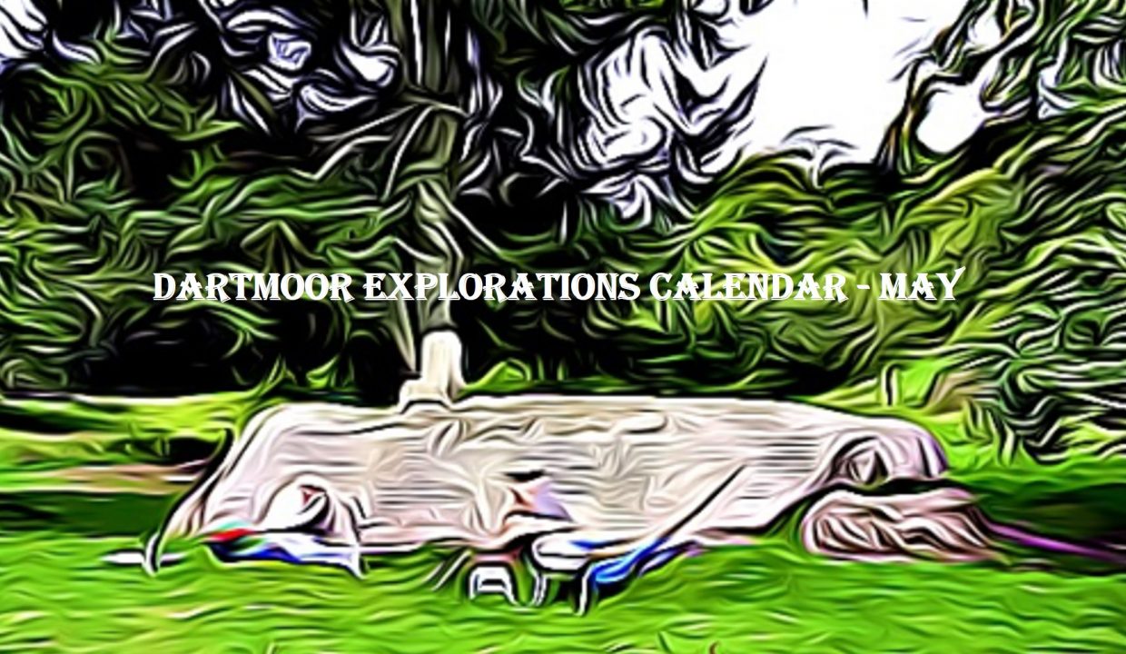
DARTMOOR EXPLORATIONS CALENDAR – MAY
In 1991, the Dartmoor National Park Authority (DNPA) published a spiral bound diary to commemorate their fortieth anniversary (1951-1991), called “The Dartmoor Diary”.
Inspired by this publication (and some of the entries in it) and to celebrate the DNPA 70th anniversary year in 2021, the “Dartmoor Explorations Calendar” records an event or story, complemented with photographs for each day of the year.
This page of the Dartmoor Explorations Calendar celebrates May on Dartmoor and its immediate borderlands.
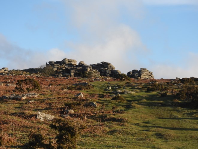
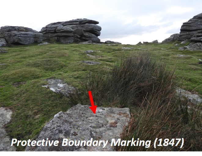
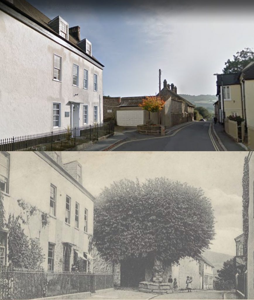
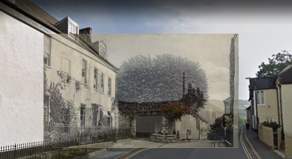
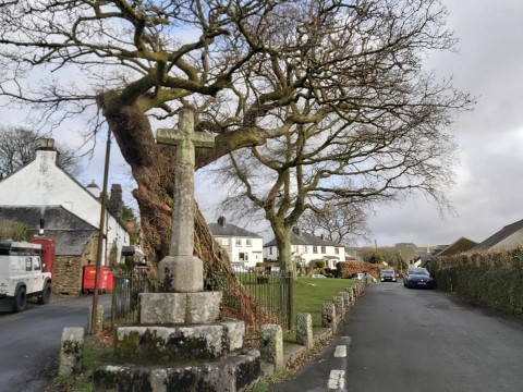
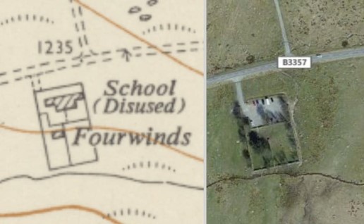
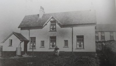
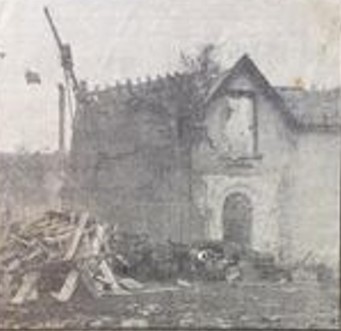
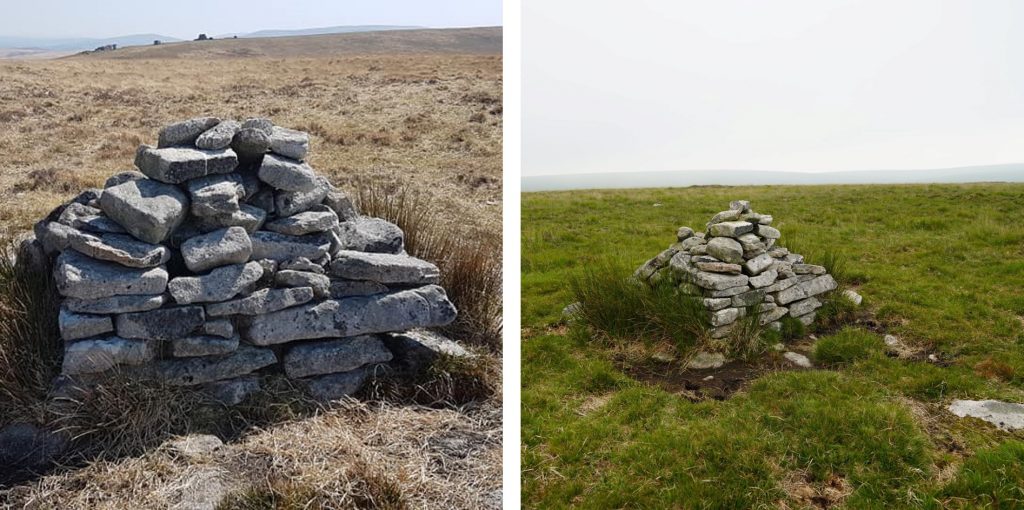
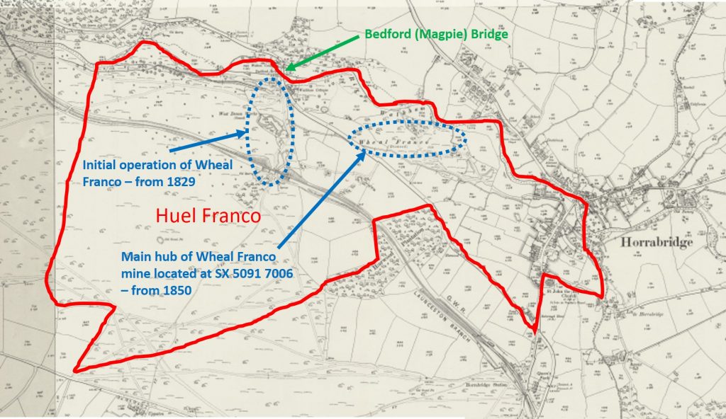
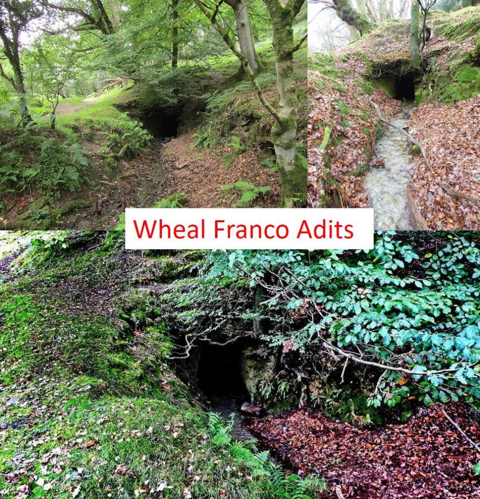
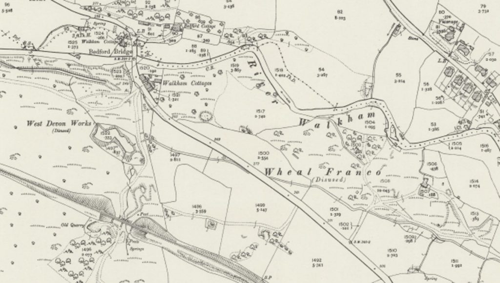
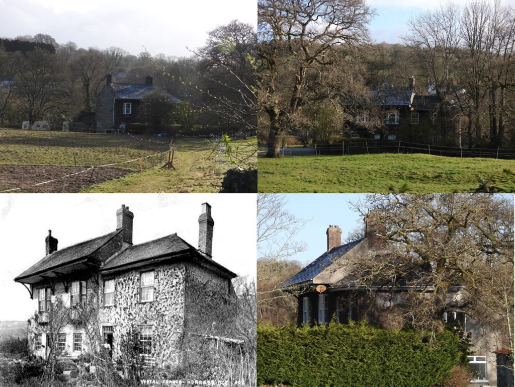
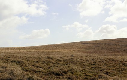
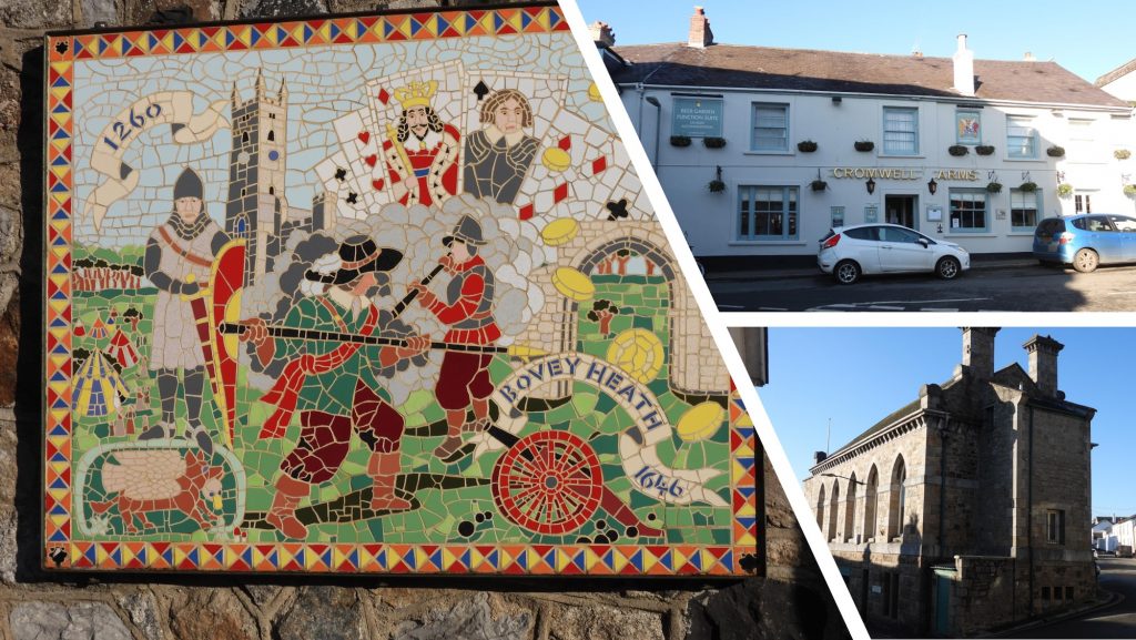
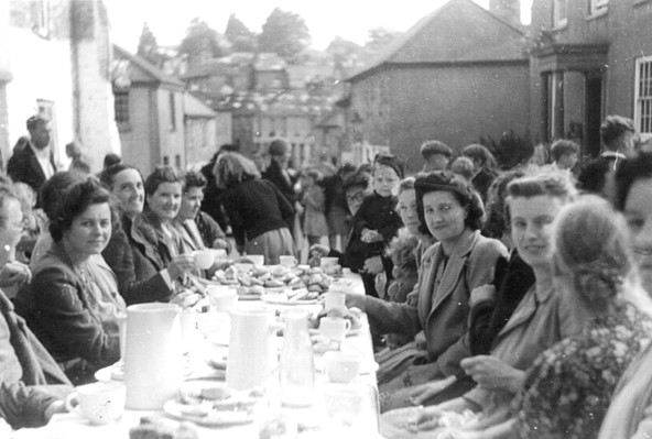
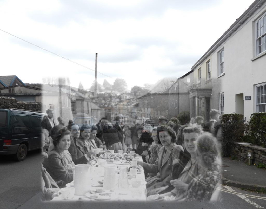
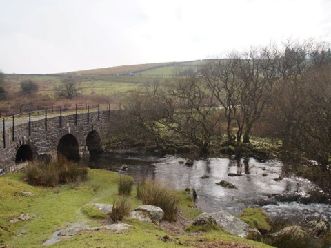
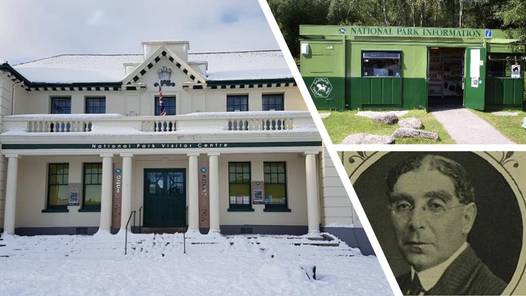
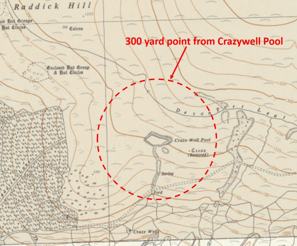
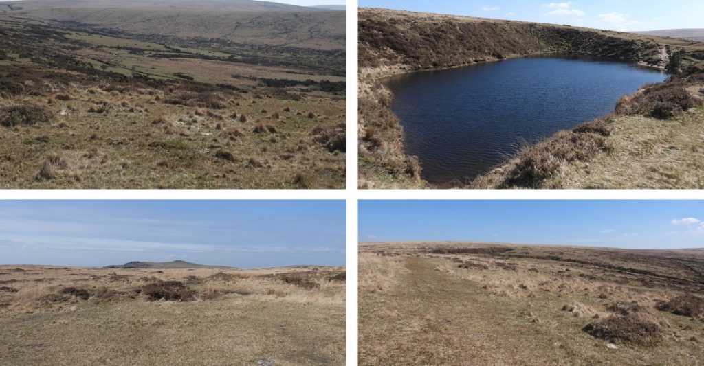
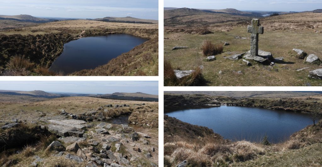
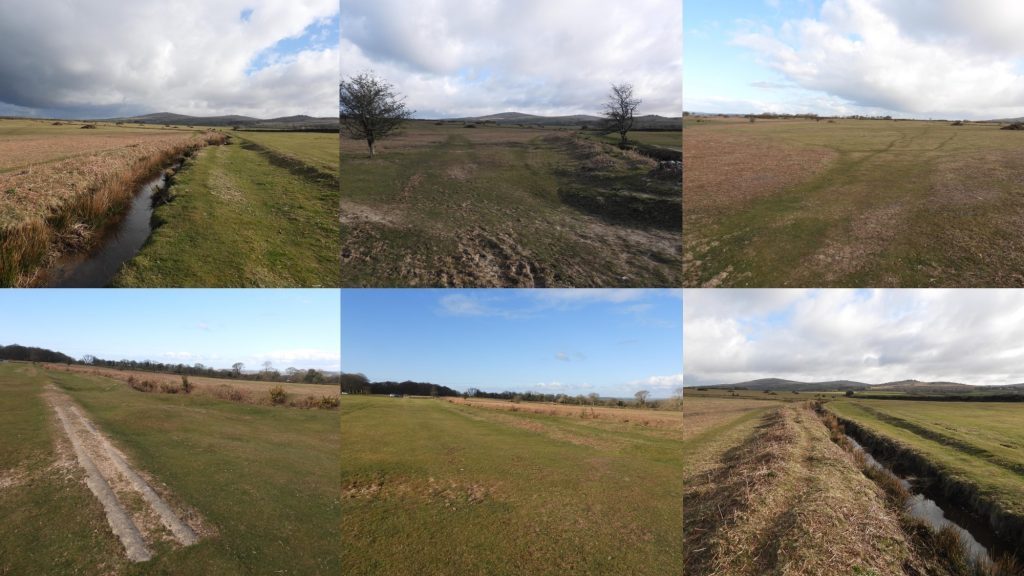
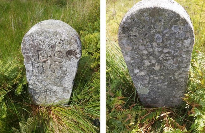
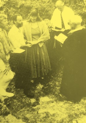
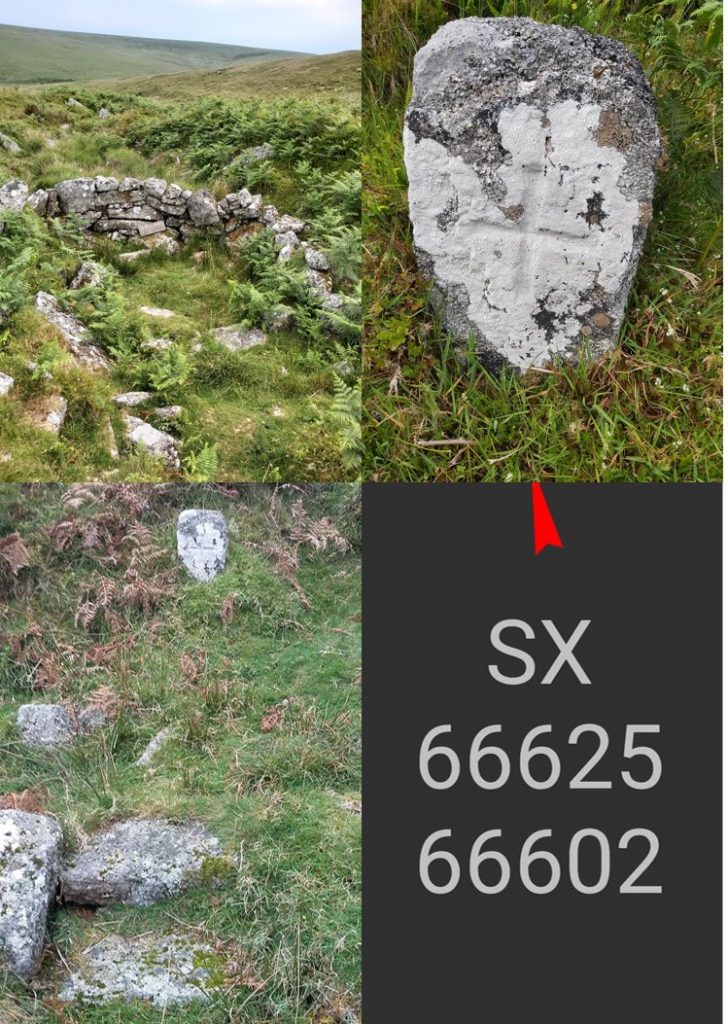
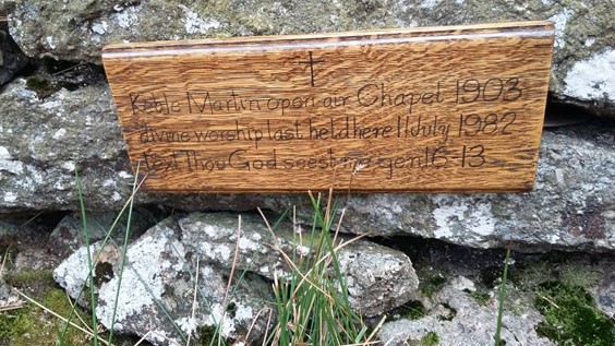
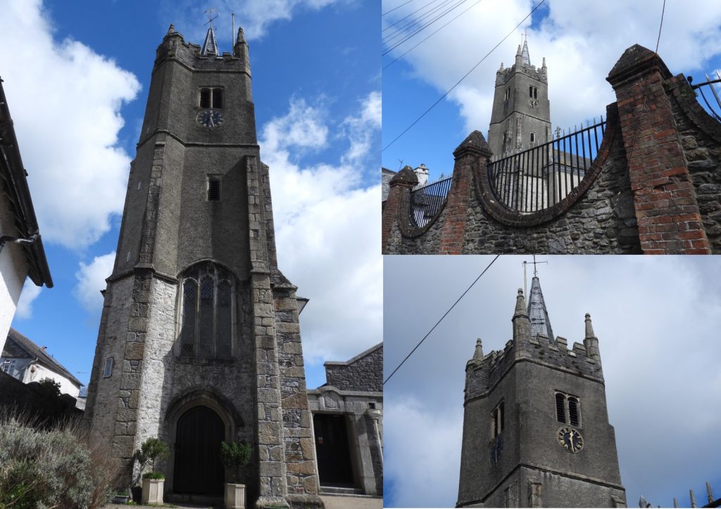
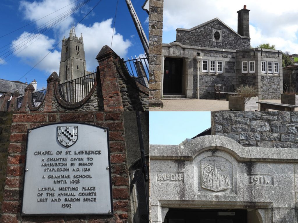
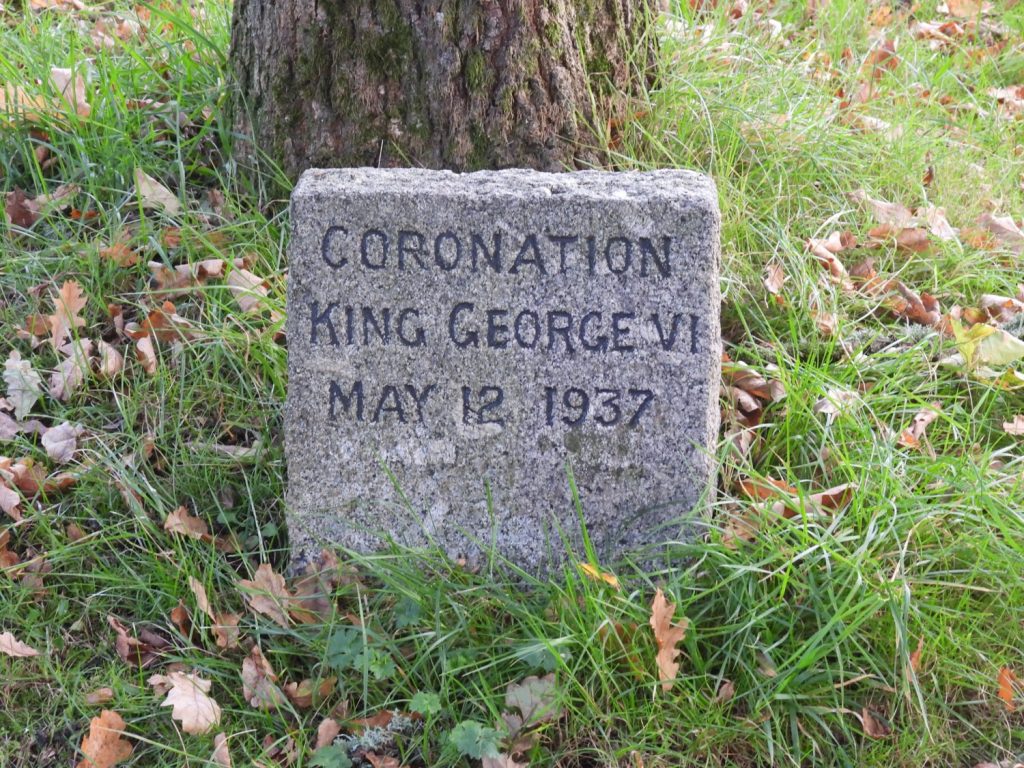
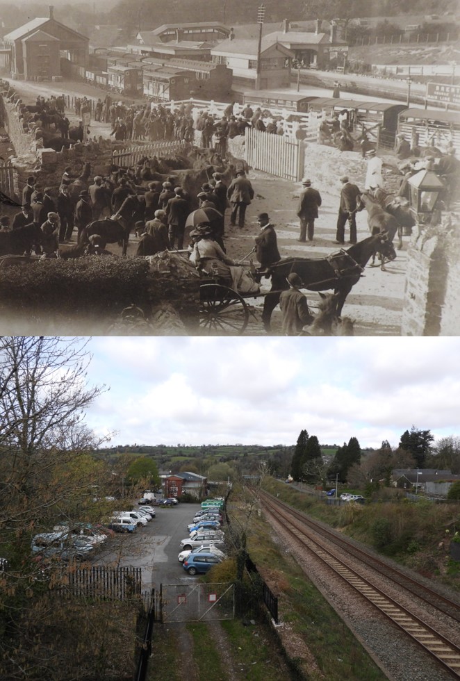
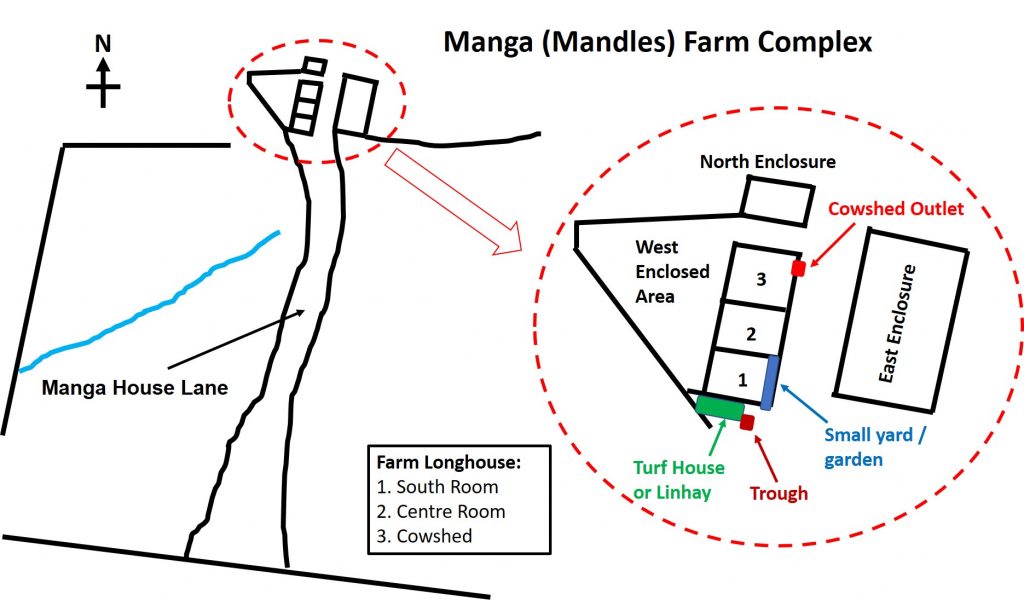
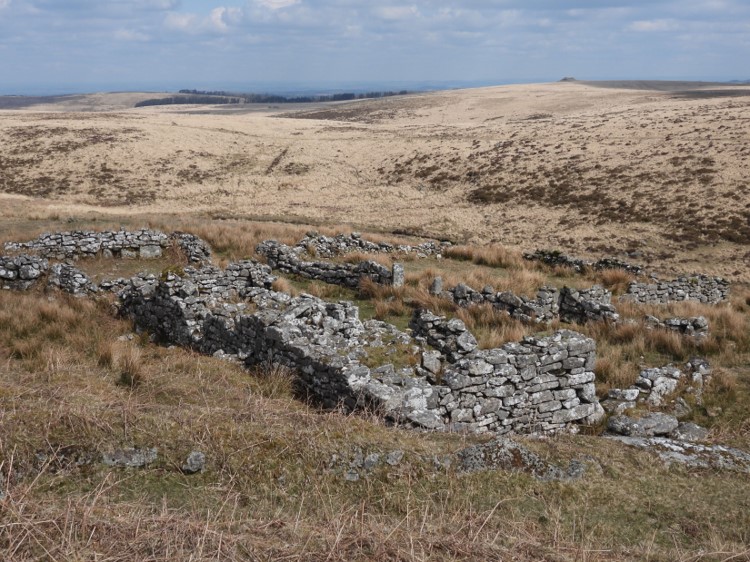
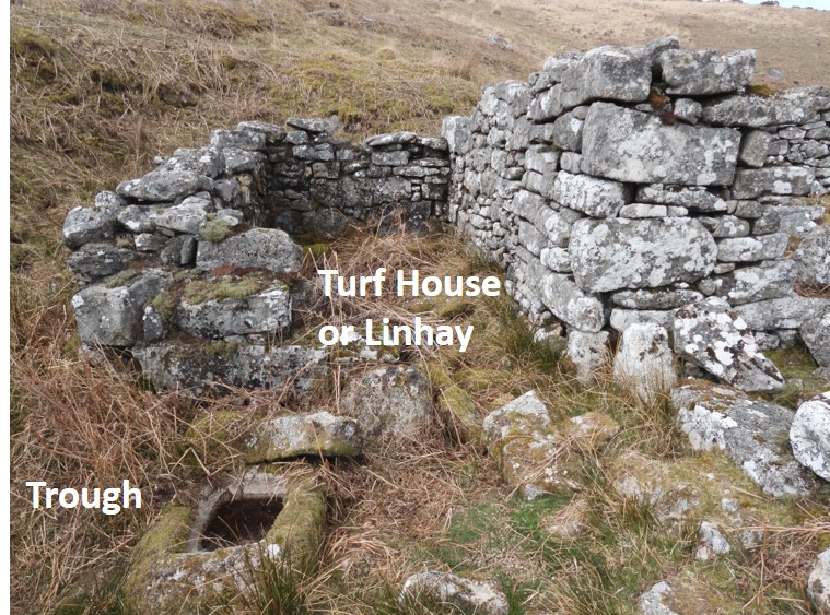
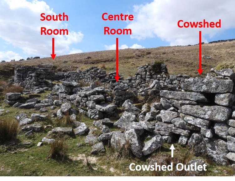
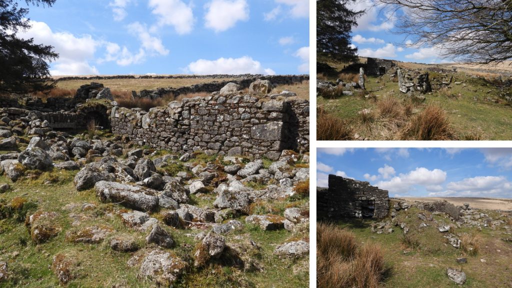
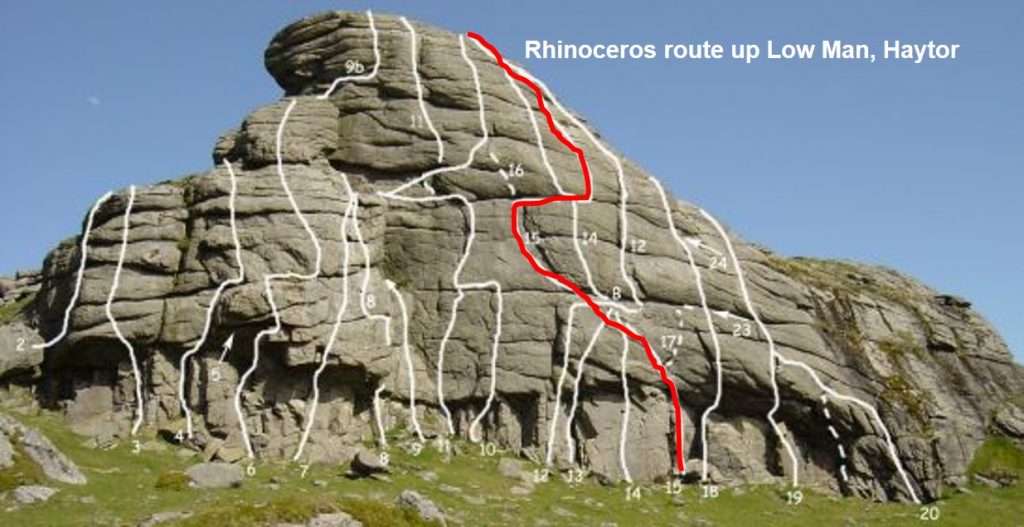
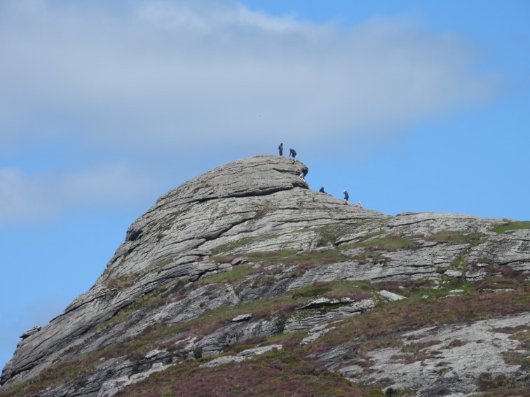
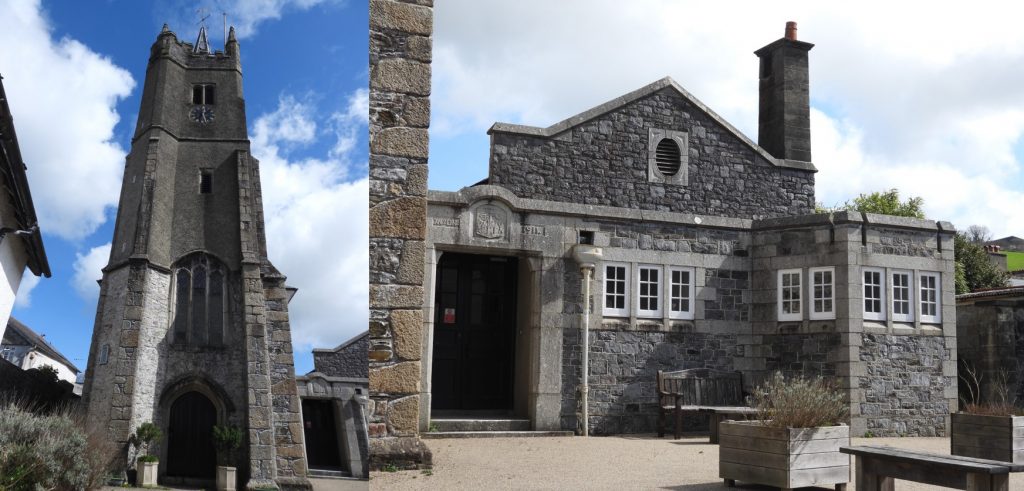
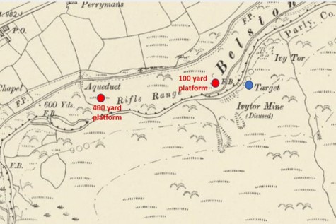
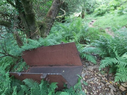
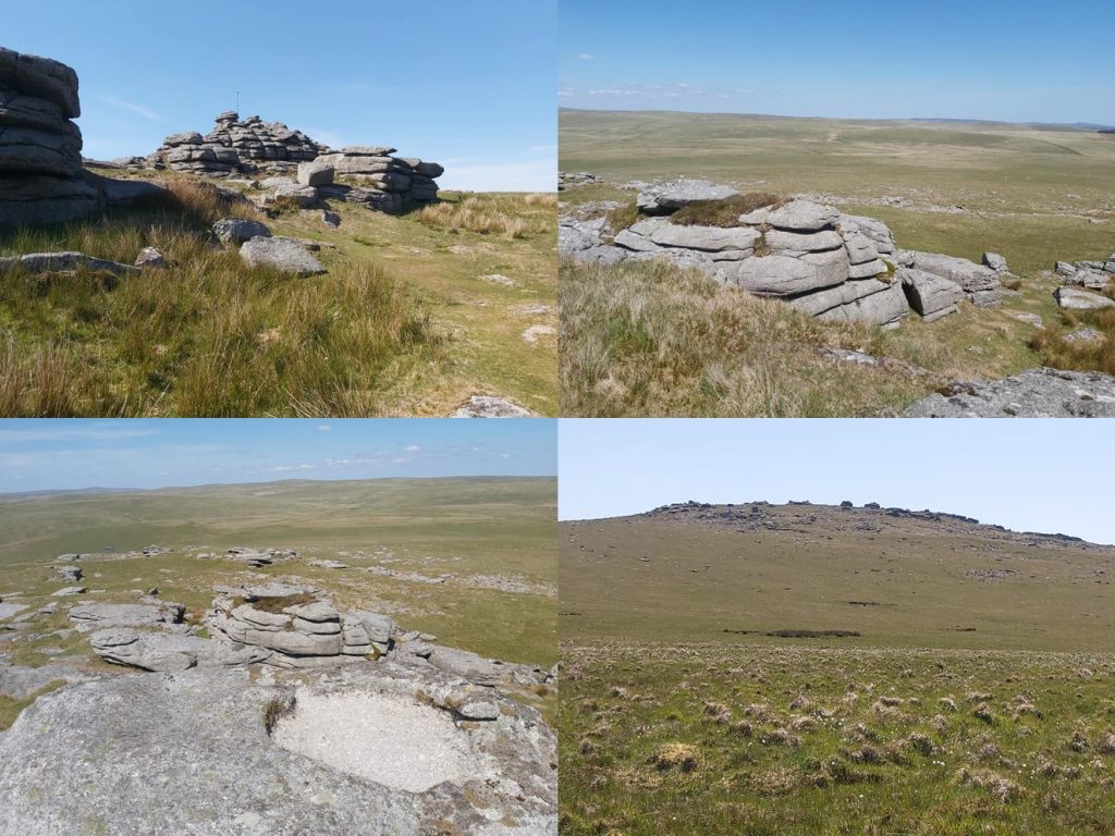
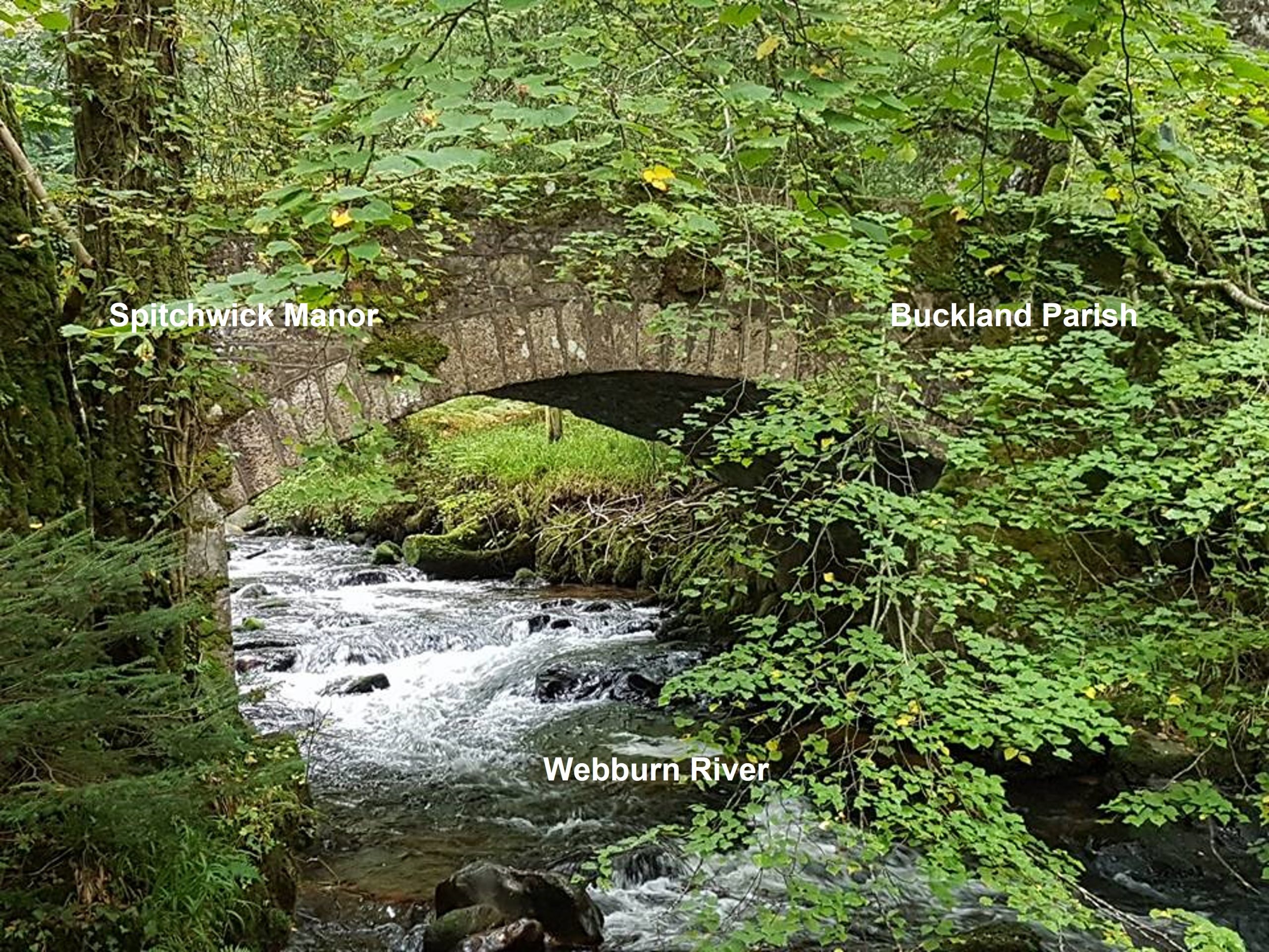
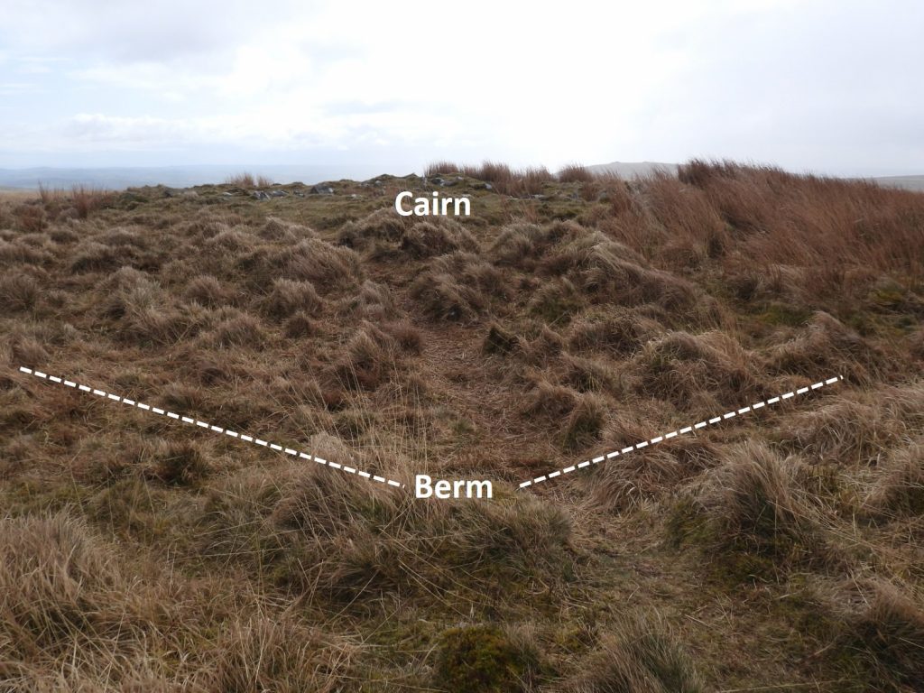
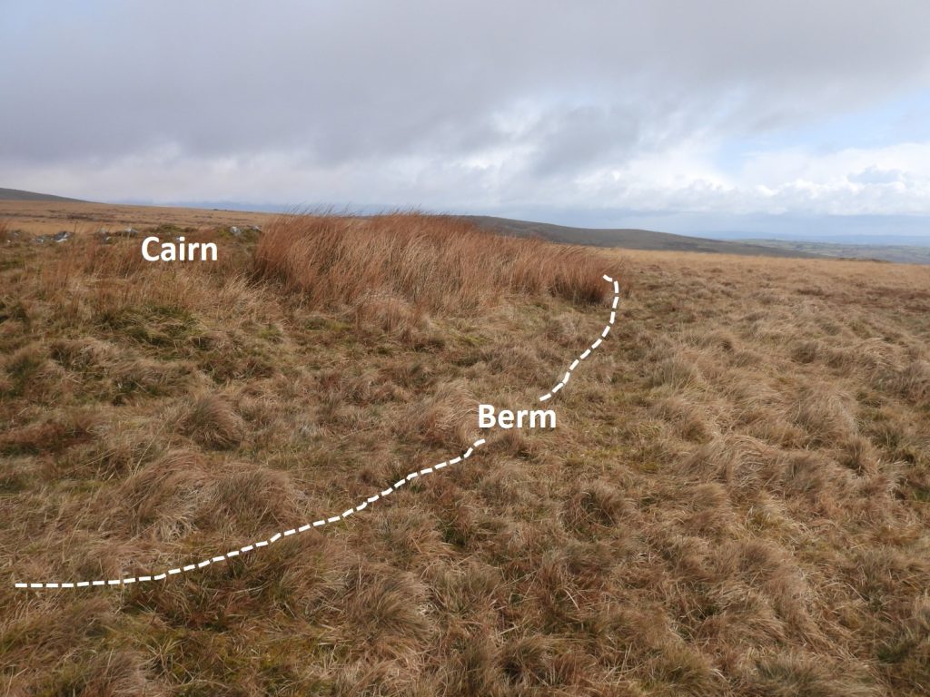
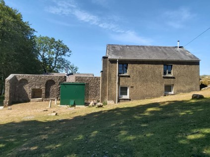
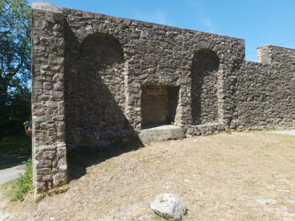
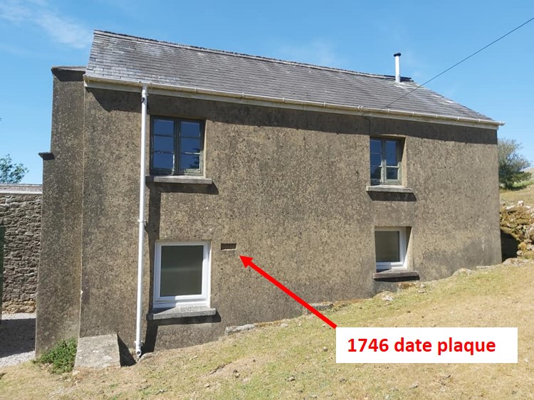
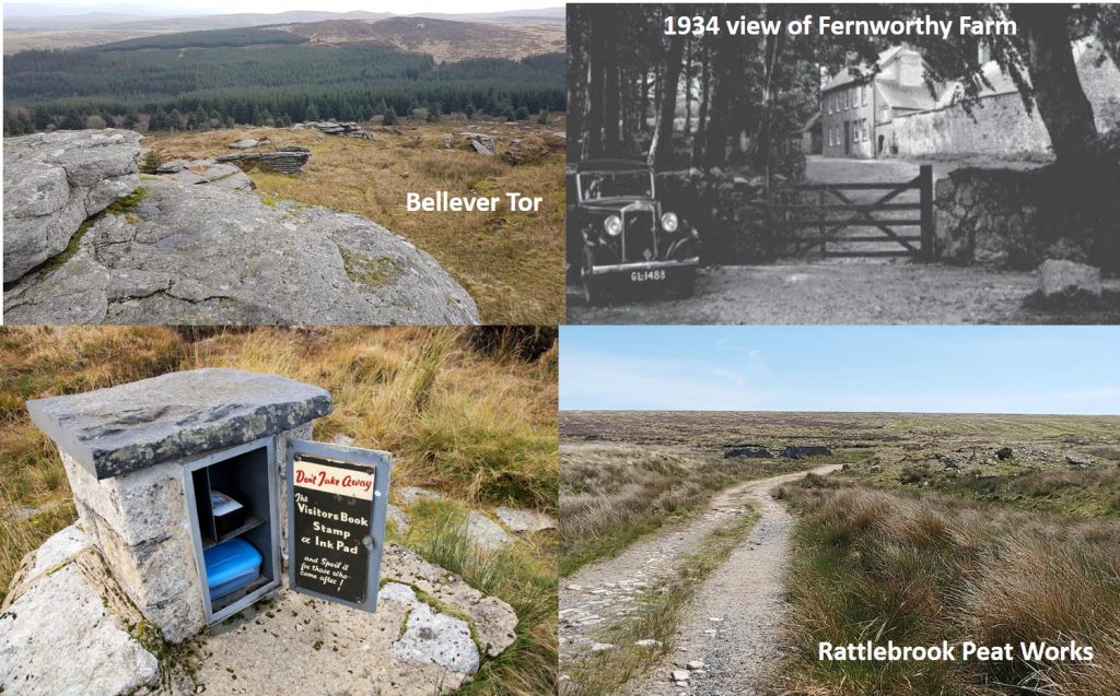
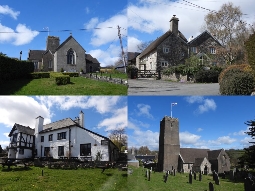
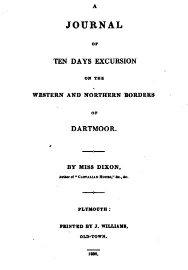
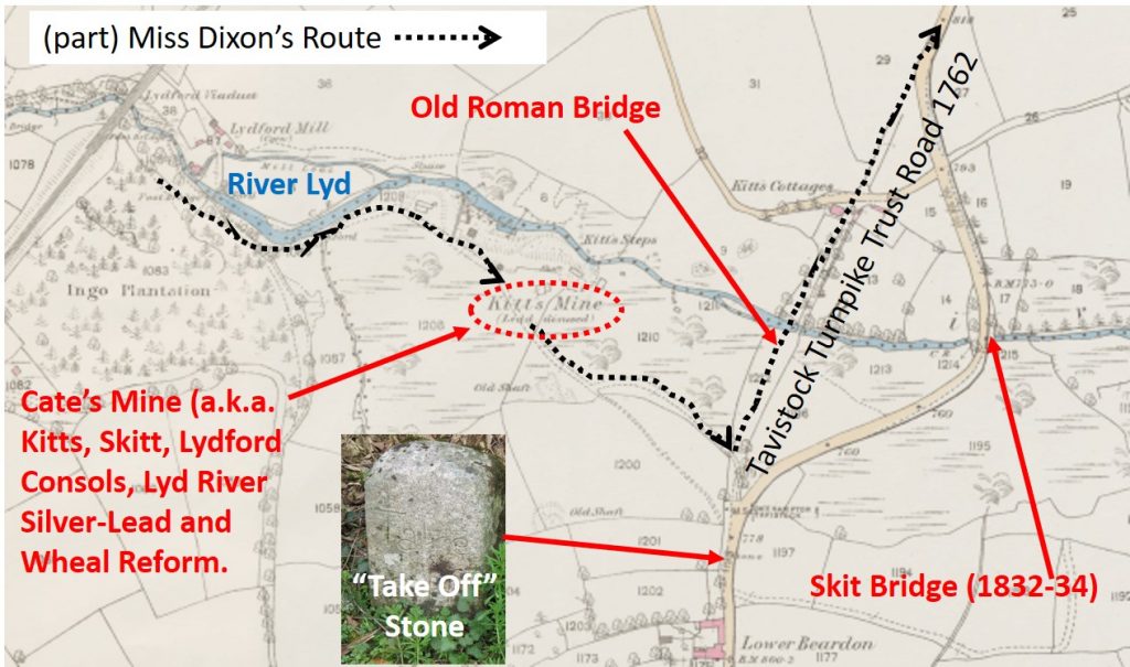
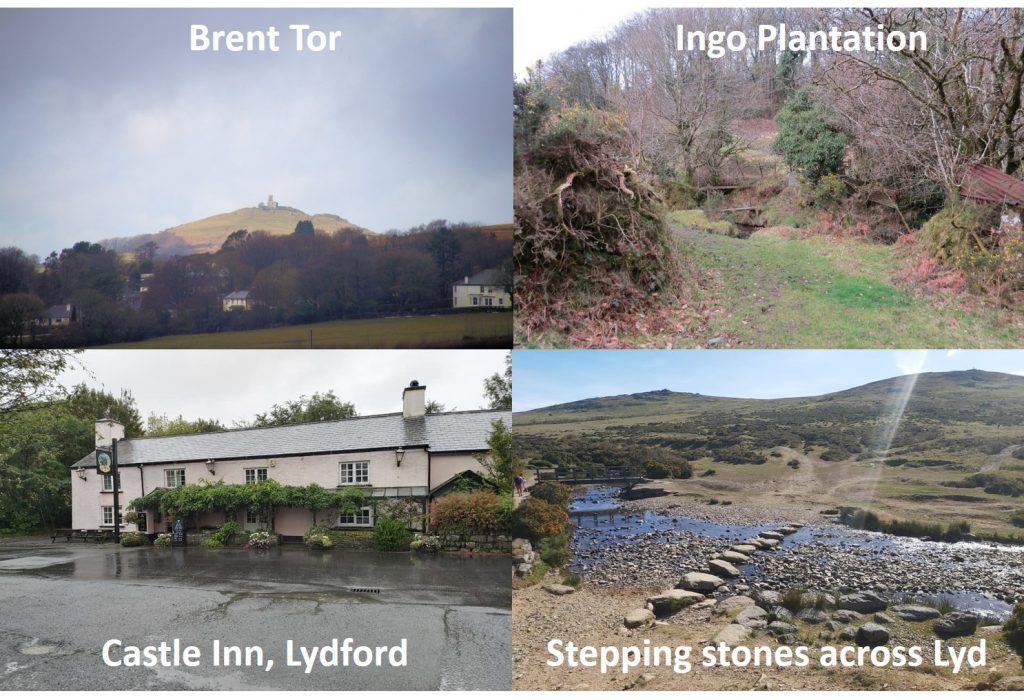
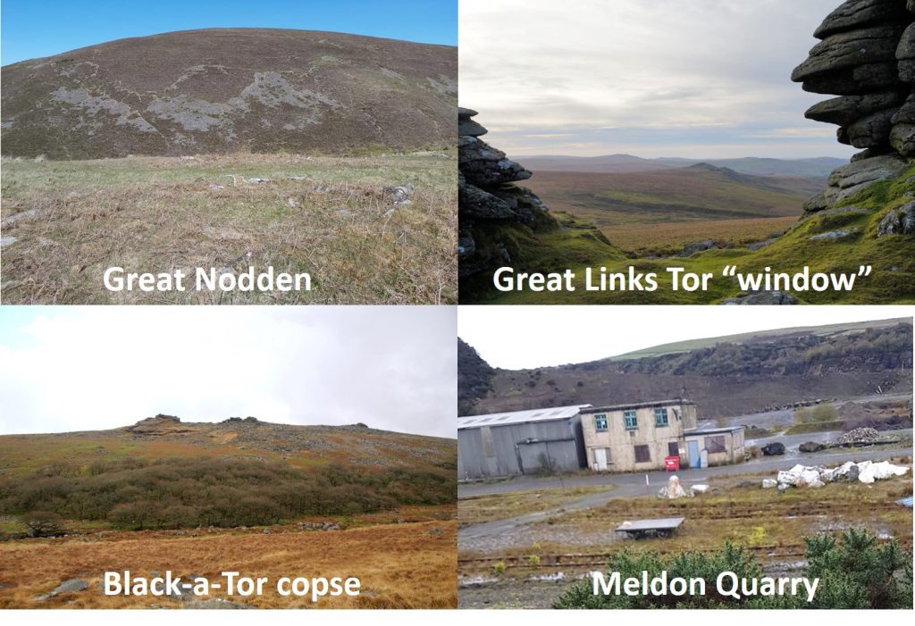
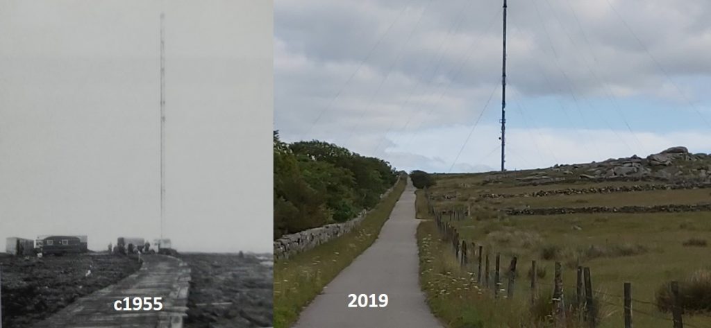
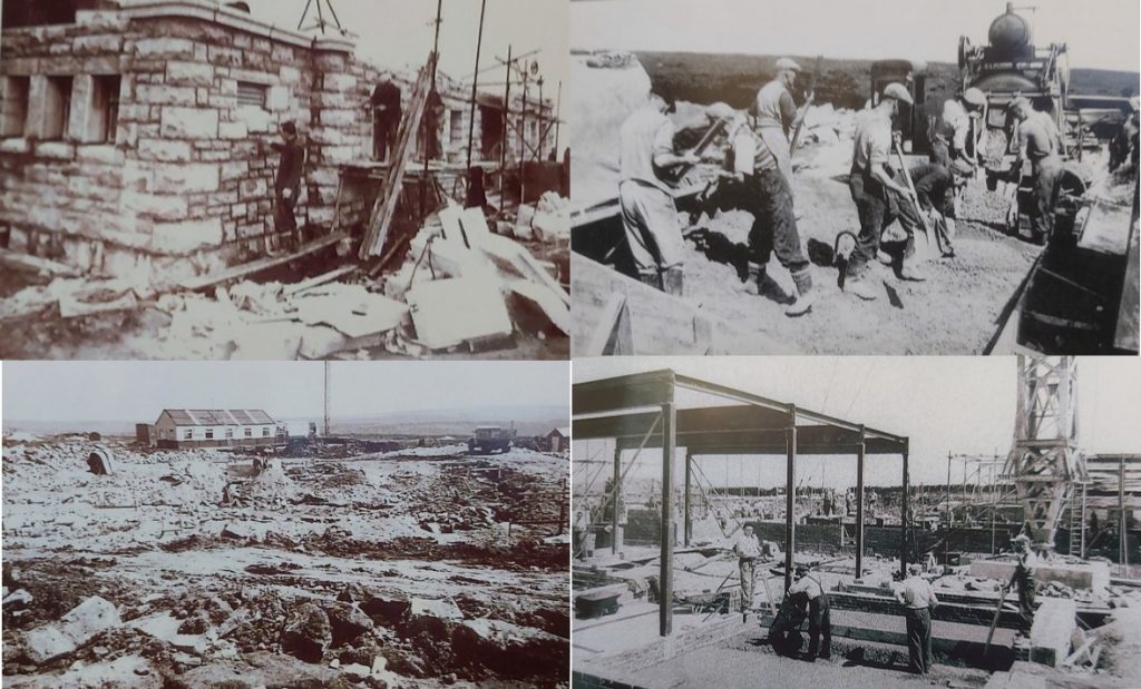
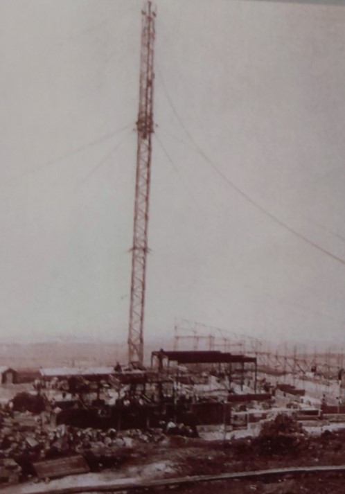
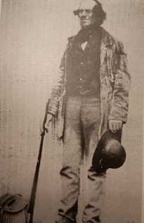
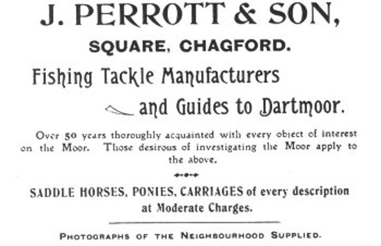
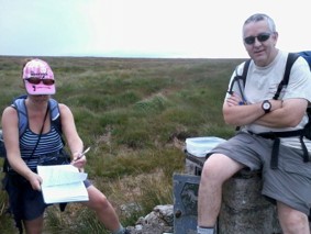
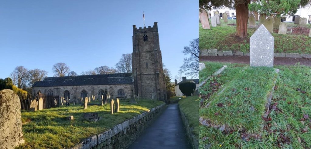
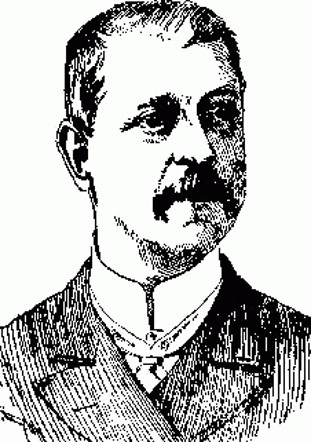
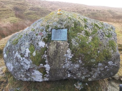
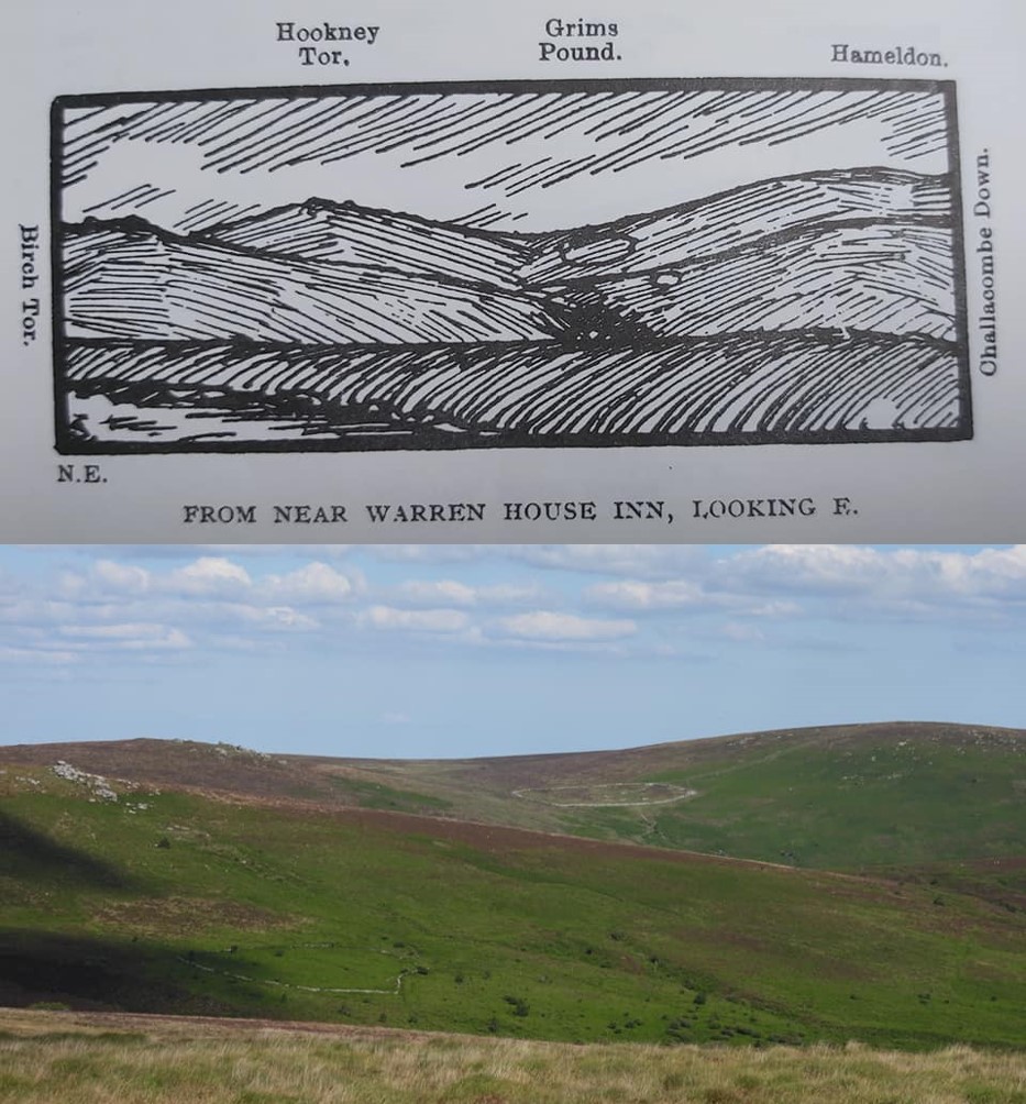
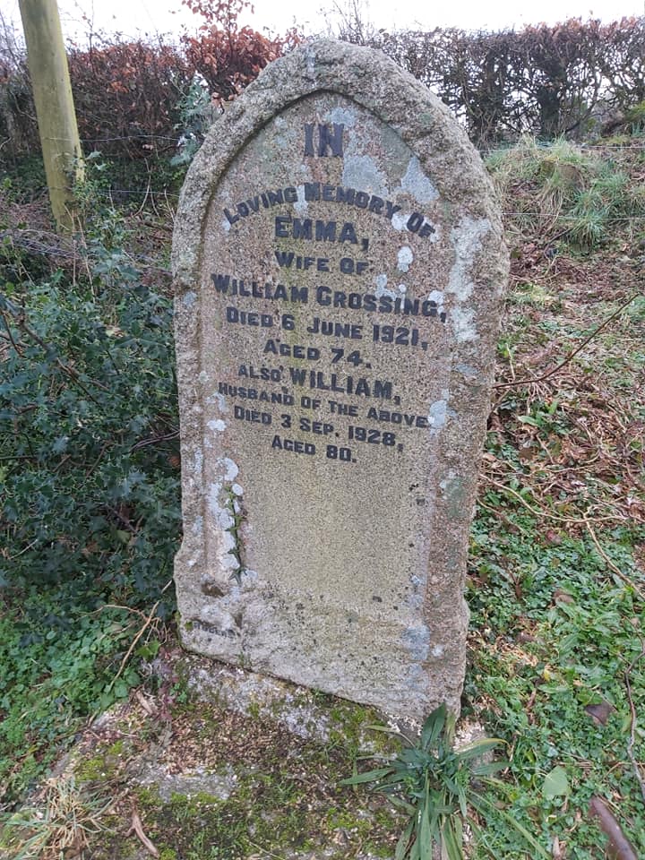
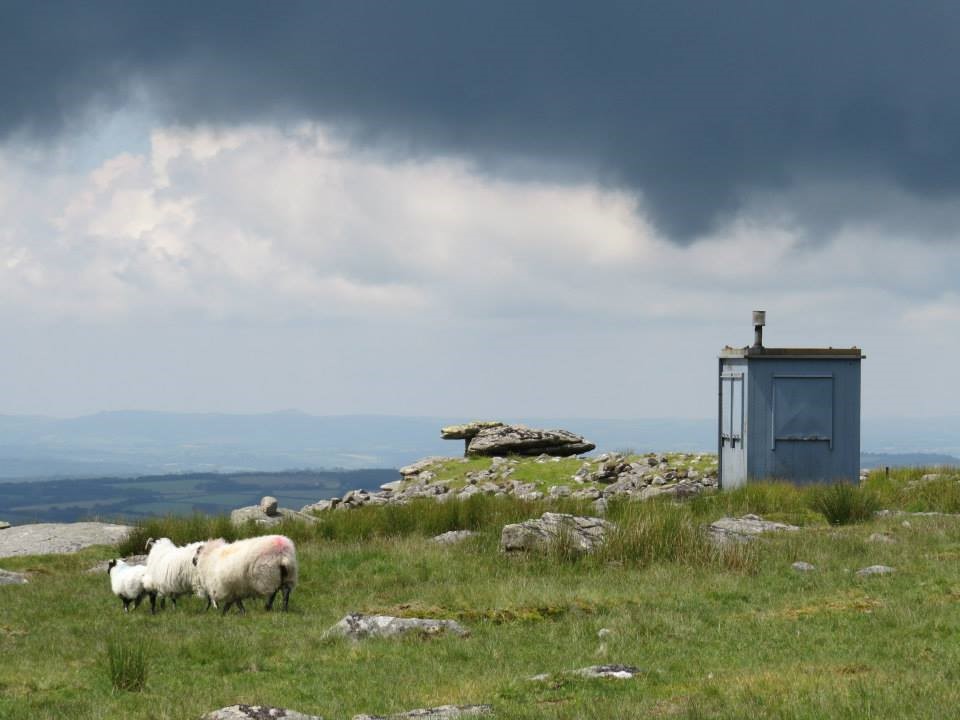
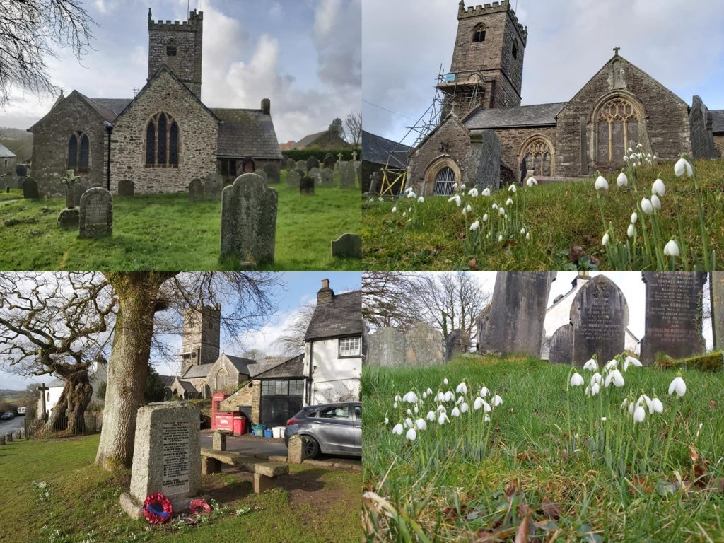
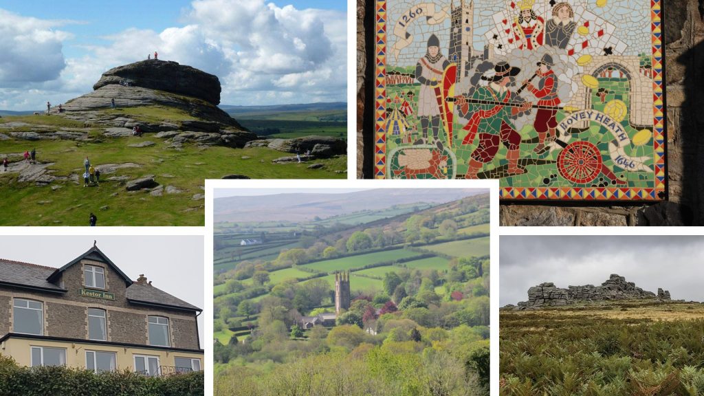
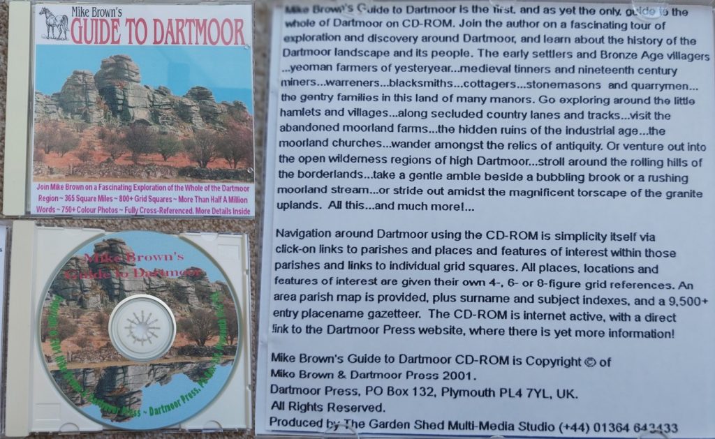
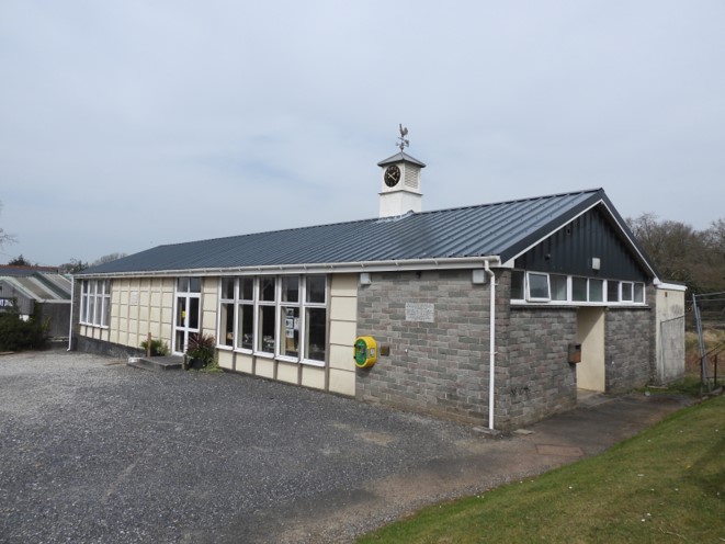
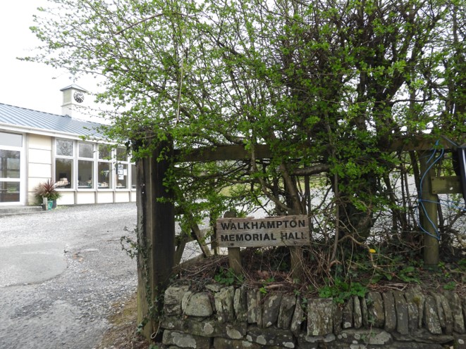
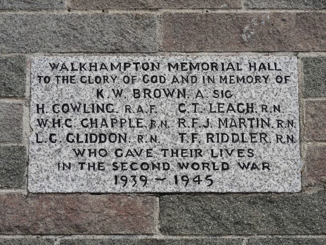
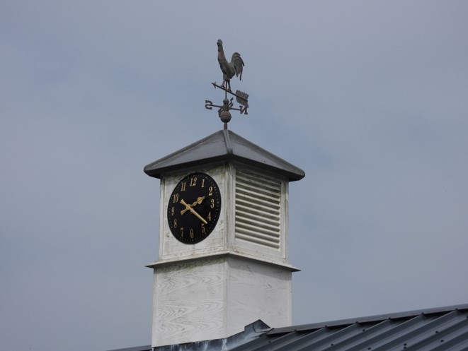
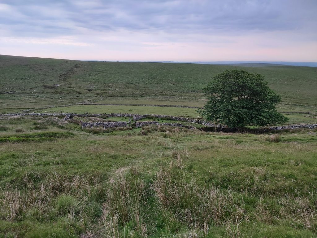
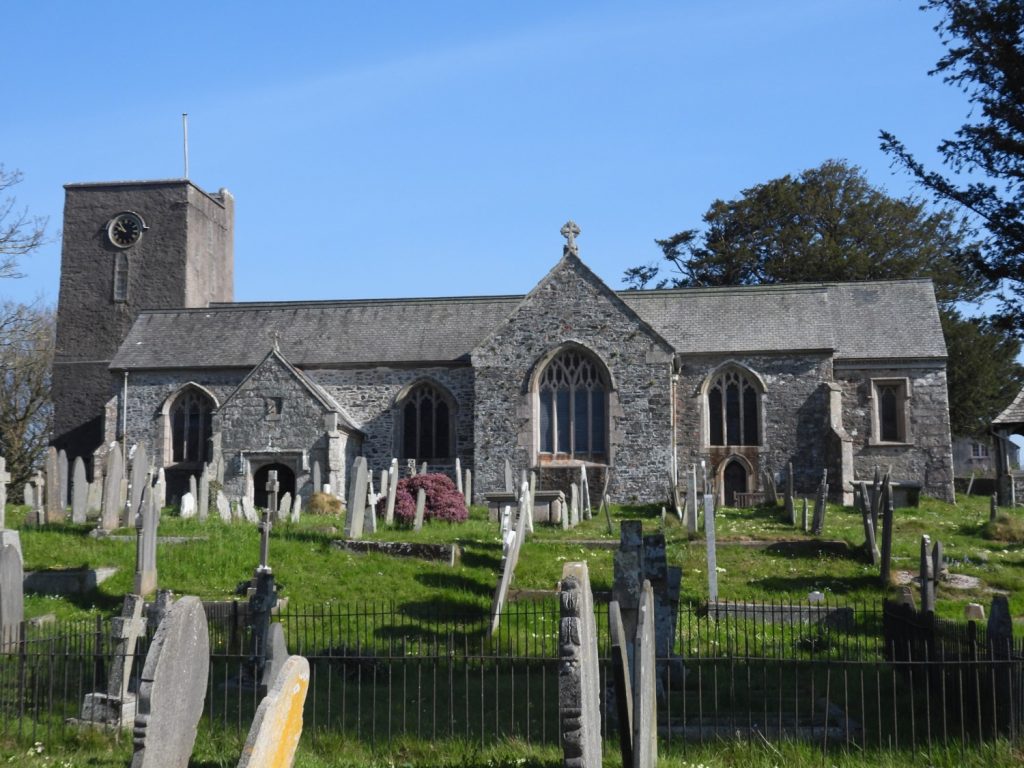
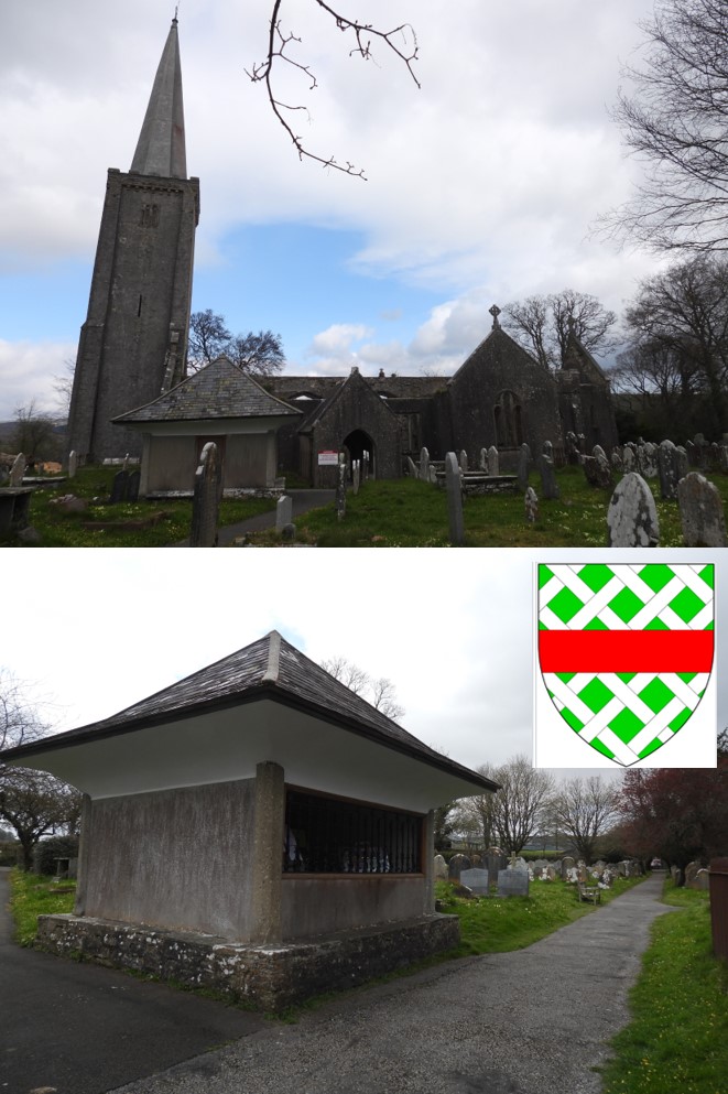
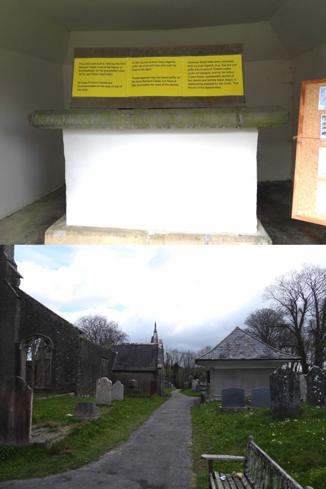
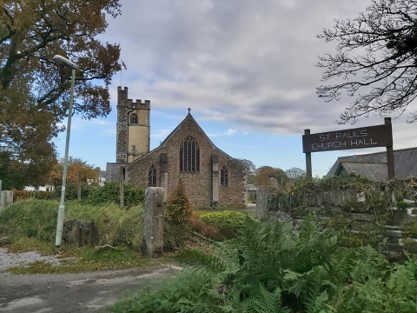
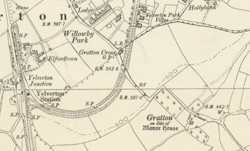
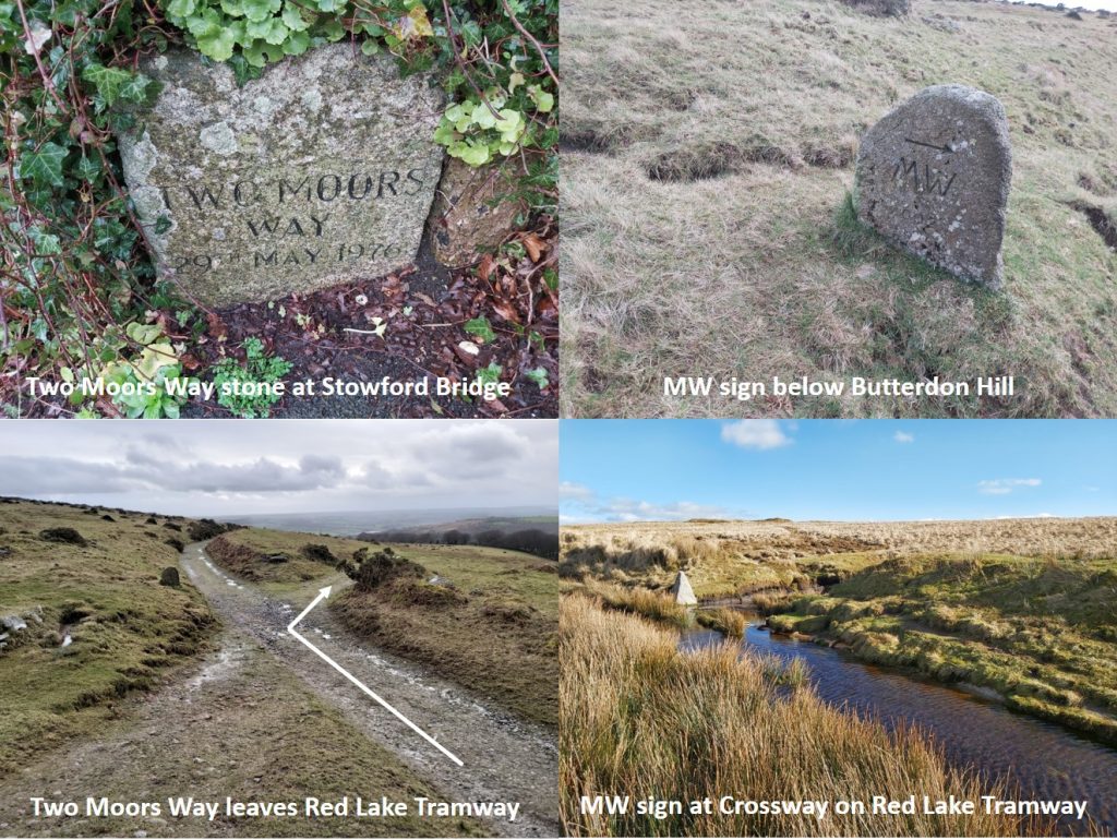
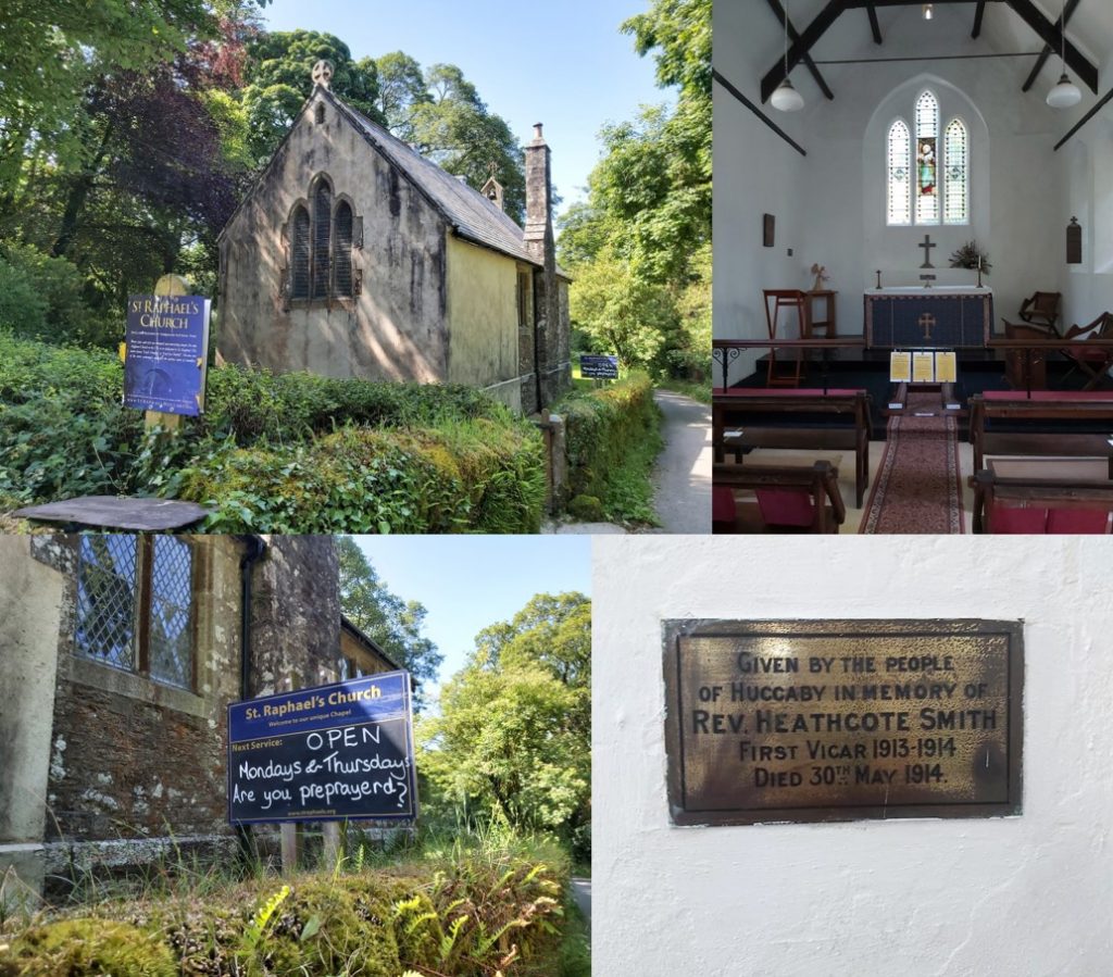
1st May 1960: The Christian custom of welcoming May day was held at the top of Pew Tor. The service was held at 0800 and was conducted by the Reverend Michael Newman, whereby the congregation “thanked God for the beauty of his grandeur”. The picture was taken early January 2021 from the south side of the tor.1st May 1960: The Christian custom of welcoming May day was held at the top of Pew Tor. This service was conducted for the second successive year. The picture is from near the top of the tor and is of a “hot cross bun” inscribed rock (one of nine), which set the limits in 1847, within which it was forbidden to remove stone.1st May: In Moretonhampstead (and possibly Meavy), the villagers would centre their May Day celebrations around the “Dancing Tree”, which was an adaptation of the Maypole traditions. In Moretonhampstead, the tree was known as the Cross Tree, the Punchbowl Tree or the Dancing Tree. It was a pollarded elm whose branches were at one time trained into the shape of a punch bowl. The then and now pictures show a comparison.1st May: In Moretonhampstead (and possibly Meavy), the villagers would centre their May Day celebrations around the “Dancing Tree”. It is interesting to attempt to superimpose the old picture on a modern colour one for the Moretonhampstead tree. The tree dates back to at least to 1790, when it is believed it was already big enough to hold tables and chairs. It grew through the base of what may well have been a very old cross to the south of the church, giving its name to Cross Street. 1st May: In Moretonhampstead (and possibly Meavy), the villagers would centre their May Day celebrations around the “Dancing Tree”. The Meavy Oak in picture, is stated as being as old as the first consecrated church here (1122).1st May 1979: The 96 day long public enquiry into the proposed Okehampton by-pass began. The main picture was taken showing the town from the map location marked “St. Michael’s Bungalow”. The road cannot be seen from here but certainly it can be heard !1st May 1994: The final service took place at St. Michael and All Angels, Princetown. (Ref: Mike Brown – Dartmoor 2001 – A Dartmoor Diary of Yesteryear). The church was built between 1812 and 1814 with permission for the construction of the church having been given 1812 by the Lord Commissioners of the Admiralty. It was designed by the architect Daniel Alexander and built initially by prisoners from the Napoleonic Wars before being finished by those captured during the American who were held in the prison1st May 1994: The final service took place at St. Michael and All Angels, Princetown. Sign outside the main door indicating that it is maintained by The Churches Conservation Trust. The church was declared redundant on 1st November 1995, and was vested in the Trust on 8th January 2001.1st May 1994: The final service took place at St. Michael and All Angels, Princetown. Inside the church, the flags are the Union Flag, the United States Flag and the French Flag. 1st May 1994: The final service took place at St. Michael and All Angels, Princetown. The east window stained glass was installed in 1910 in memory of the American prisoners who helped build the church and depicts the life of Christ. The window is by Mayer of Munich and was was partially funded by a donation of £250, in 1908, from the National Society United States Daughters of 1812 as part of their work commemorating those who died in the War of 1812.2nd May 1969: Featured in The Western Morning News under Personal. ‘CHAGFORD RESIDENTS – will all residents interested in the suggestion of Yellow Lines parade in CHAGFORD SQUARE at 11 till 11.15 a.m on SATURDAY 10 MAY. Those in favour are invited to stand in the centre of the square and those against to stand on the peripheral pavements. Our elected Councillors can thus be shown what the electors want’. The above picture was taken New Year’s Eve, 2019.2nd May 1964: Foggintor School was demolished in 1964 by 10 schoolboys. The map is post 1936, as that is when the school closed. The name “Four winds” was the newly acquired private dwelling, which used to be the school house. The name has stuck to this day as the car park is known as Four Winds Car Park.2nd May 1964: Foggintor School was demolished in 1964 by 10 schoolboys. This is the back of the old school house, probably taken from approx location of the fir tree. The school can be seen on the right. The caption is ‘The headmaster, Mr Stoyle, his wife and their son Ivan pose for the photographer at the rear of the Headmaster’s House’2nd May 1964: Foggintor School was demolished in 1964 by 10 schoolboys. The school was demolished in 1964 and the house in 1965. Some of the stone was used for the road straightening at Devils Bridge. This picture from a local newspaper is of the house being demolished. Apparently the demolition was carried out by using the labour of ten boys from an approved school.3rd May: Stinging nettle day. A tradition on Dartmoor on 3rd May is to celebrate ‘sting-nittle day’ which formed part of the May Day tradition. “First of May is May Doll Day, Second of May is Kissing Day, Third of May is Sting-Nittle Day“. As described on the Legendary Dartmoor website, on this day children would arm themselves with stinging nettles and charge around whipping all and sundry. It was said that others would stuff dock leaves into their pockets in the event that they should get stung. Its scientific name, Urtica dioica, comes from the Latin word uro, which means “to burn,” because its leaves can cause a temporary burning sensation upon contact. The leaves have hair-like structures that sting and also produce itching, redness and swelling3rd May: Stinging nettle day. In July 2000, there was a talk in Widecombe given by Colin Ridgers on the folklore and medicinal uses of plants on Dartmoor. On Stinging Nettles he is reported to have saidthe use of their dried stems were used to make early form of fabric during 1500 and the formic acid in the plant was thought to help cure rheumatism. Also, from the Legendary Dartmoor website, “the nettle was often used in the kitchen and the tops were often lightly boiled and served as a substitute for ‘greens’, supposedly they are very high in natural proteins. Sometimes the old moorfolk would drink nettle beer, especially if they were suffering from rheumatics, lumbago or gout”.3rd May 1219: Henry III directed a writ to William Briwere commanding him to ‘permit the men of Joan, Queen of England, to dig, burn and lead away from the turbary of Dartmoor to her stannary as they used and ought’ – this was in connection with the production of charcoal for processing tin ore. Source: The Dartmoor Diary 1991 by DNP. The pictures is are of a Peat Burning Platform near Wild Tor which is believed to have been constructed between 1100 AD to 1900 AD. The level platform was prepared with circular tiers of dried peat bricks with horizontal vents to admit a controlled air flow. Sites for peat charcoal burning were always on raised ground within areas of visible turf cutting and, on Dartmoor, between altitudes 465 metres and 545 metres. Source: Dartmoor HER (SDV356948).3rd May 1979: The Dartmoor National Park authority secured its operational headquarters at Parke, Bovey Tracey by lease agreement with the National Trust.4th May 1837: Dues paid by Capt Paull of Wheal Franco in 1837 were recorded on this date as £111 09s 4d. In 1829, the sett was leased to William Patey, a Plymouth shopkeeper, John Paull the younger, a local miner, and John Boswarva, an accountant, the sett extending 300 fathoms westwards and including a small portion of land east of the main road near Bedford Bridge. Source: Mike Brown, Guide to Dartmoor CD.4th May 1837: Dues paid by Capt Paull of Wheal Franco in 1837 were recorded on this date as £111 09s 4d. The initial grant allowed “free liberty to raise and bring to grass all such Copper and other Ores Metals Minerals and Fossils as shall be there found”, and also to “spall pick wash stamp dress cleanse and make merchantable the said Ores”. They were also permitted to “drive, dig, work and make within the limits of the Premises hereby granted any new or other Adit or Adits Shaft or Shafts Pits Drifts Leats and Watercourses in over upon and through any part of the said Premises and to use those already made…” The pictures above show some of the adits. The term was for 21 years at a rent of “one Full Twelfth dish dole share or part of all such Copper…Ores [etc]…” for the first three years, then a tenth share for the remaining 18 years, and the lessees were also directed to “at their own expense and with all reasonable expedition properly spall and render fit for stamping all Tin Ores”, and further instructed to work the mine “regularly and effectually and in every respect according to the practice of good Miners and bind secure and keep open in a firm durable and miner-like manner all Adits Shafts and other workings”. All information sourced from Mike Brown’s Guide to Dartmoor CD.4th May 1837: Dues paid by Capt Paull of Wheal Franco in 1837 were recorded on this date as £111 09s 4d. On 17th December 1850, Sir Ralph Lopes leased the sett to three new adventurers, Christopher Bridgman, William Burnell and Samuel Treeby, and the main centre of activity was transferred to a site just northwest of the village (now on private land, where Franco farm is located). The sett was also extended to take in the eastern part of Horrabridge north of the road over Knowle Down to Walkhampton. Conditions were again essentially the same as those in the earlier leases, the rent by then having been reduced to an eighteenth share per annum.4th May 1837: Dues paid by Capt Paull of Wheal Franco in 1837 were recorded on this date as £111 09s 4d. On the post 1850 sett, there is little to see today as its on private land, where Franco farm is located. The whole Wheal Franco copper mine operated until 1875. It was very productive, employing around 130 men and going down to 160 fathoms (960 feet).
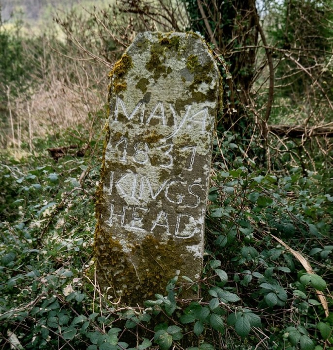
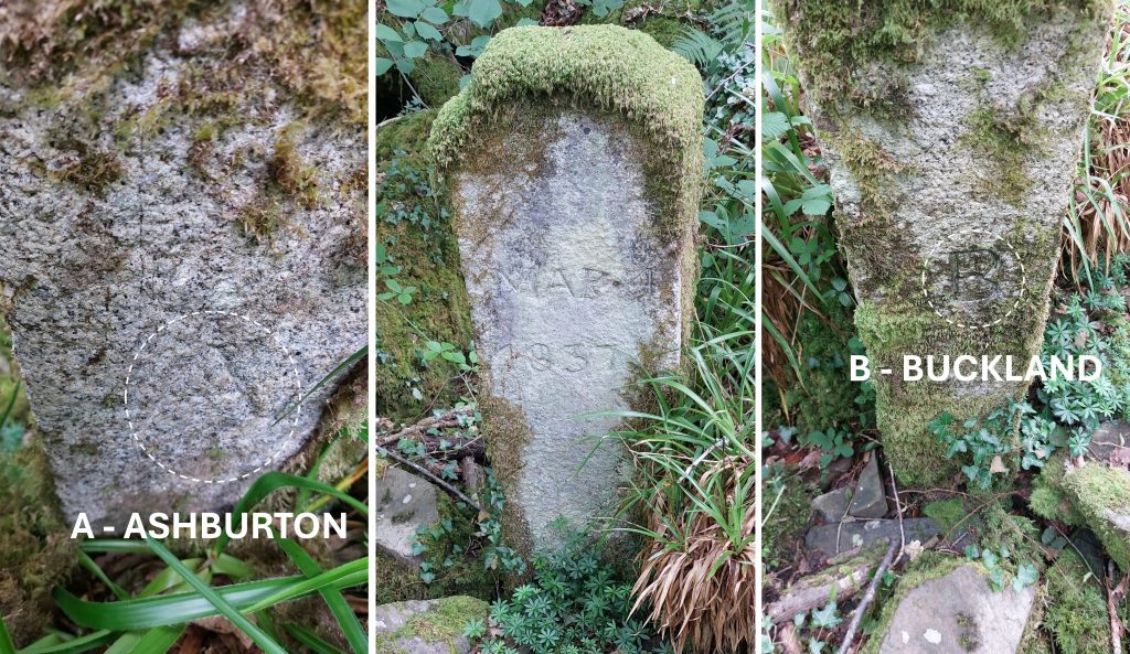
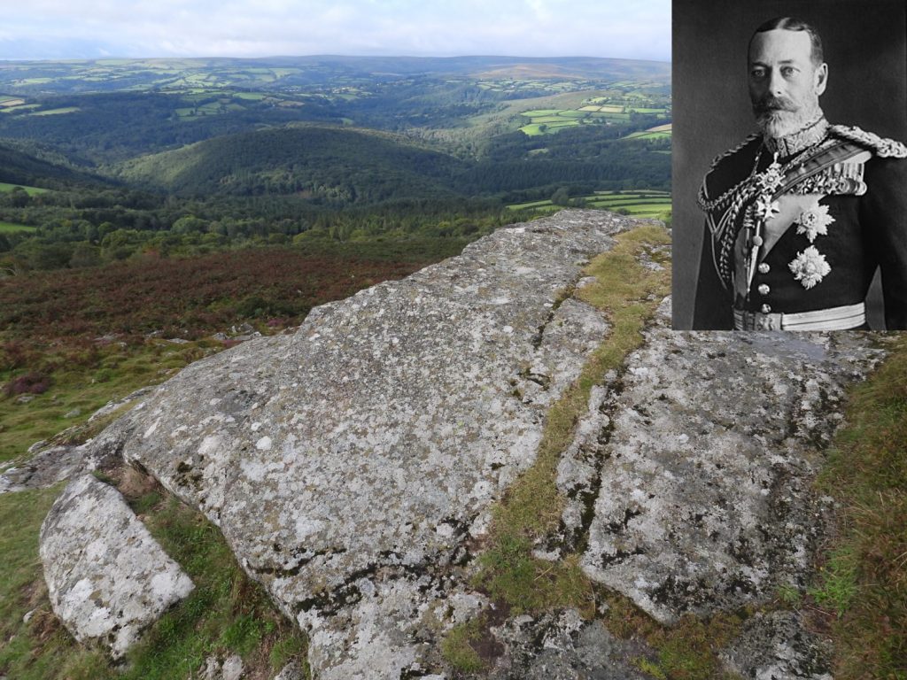
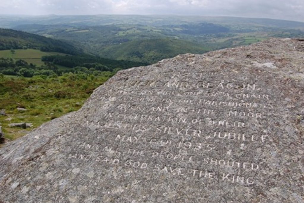
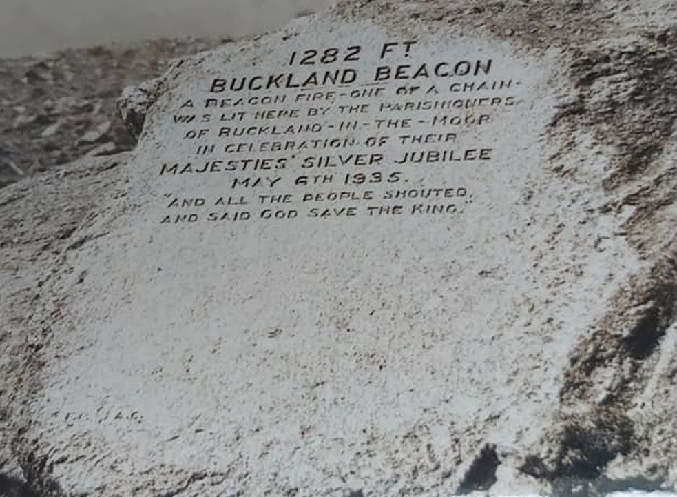
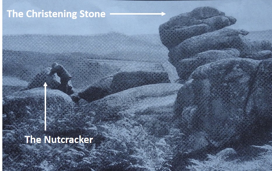
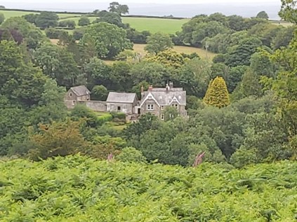
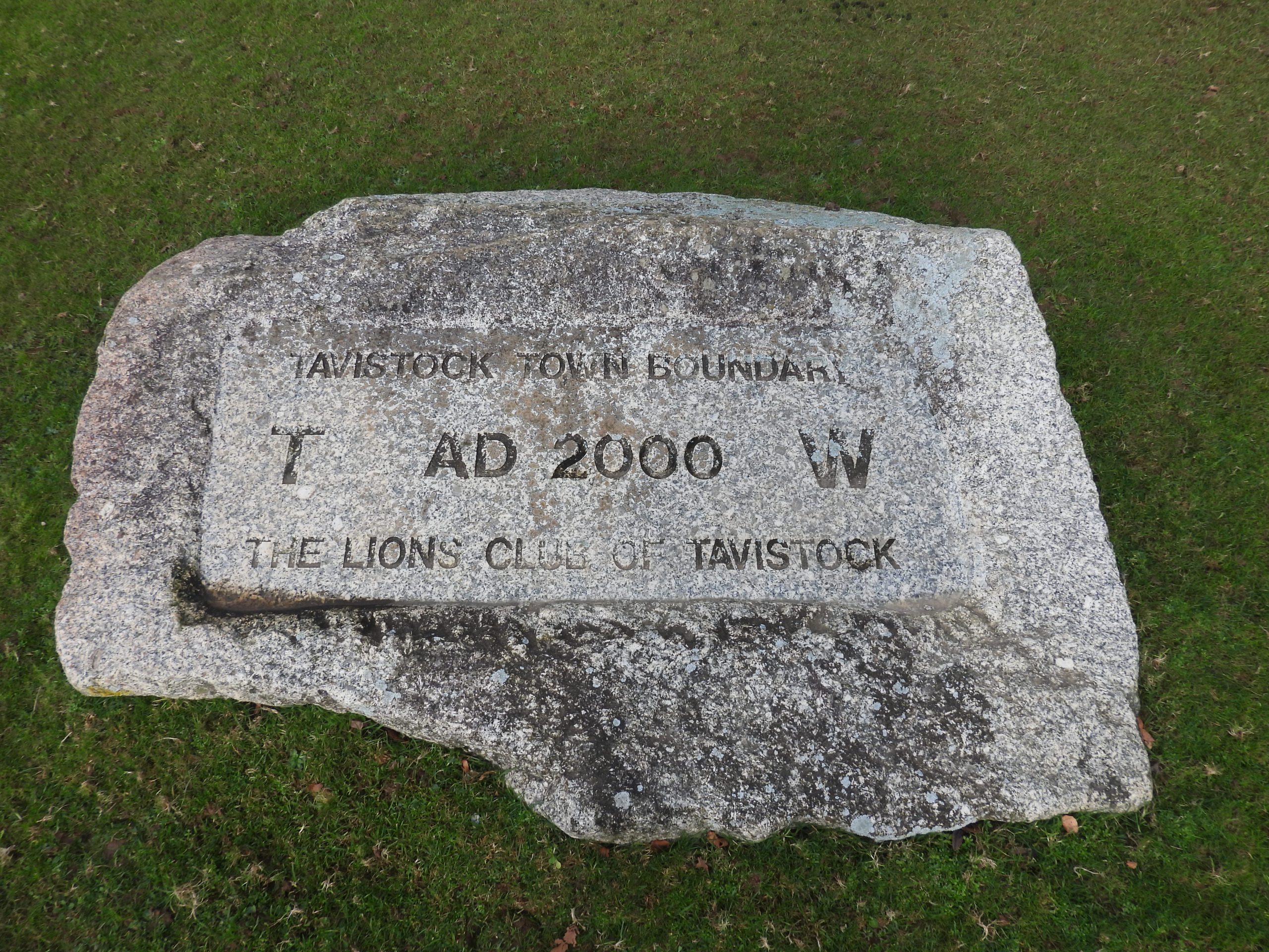
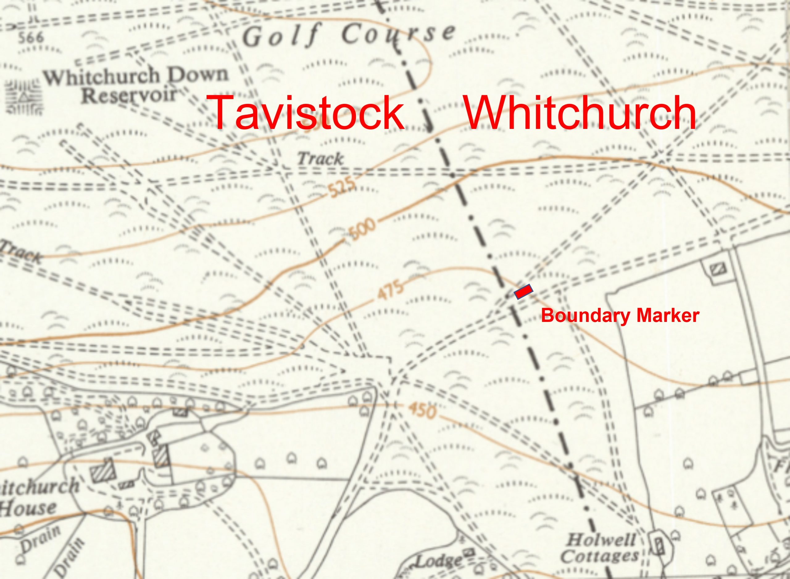
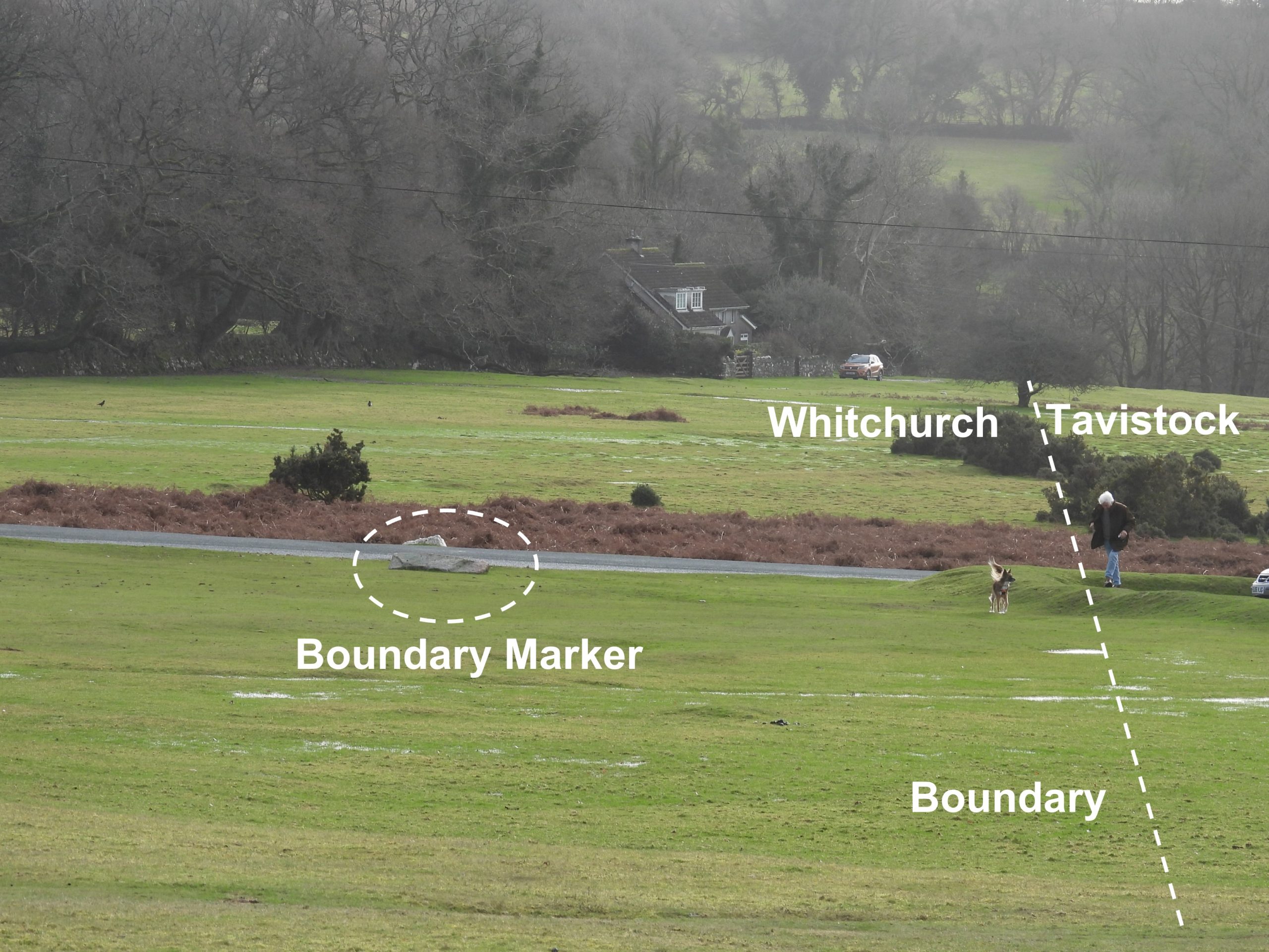
4th May 1837: Two new boundary stones were erected during a view of the bounds of Buckland-in-the-Moor. The above stone is located at SX72829 72308 and marked as ‘Muswell’ on old maps. It has an ‘A’ (Ashburton) and ‘B’ (Buckland) inscribed on opposing faces. On the front face it is inscribed ‘MAY 4 1837 Kings Head’
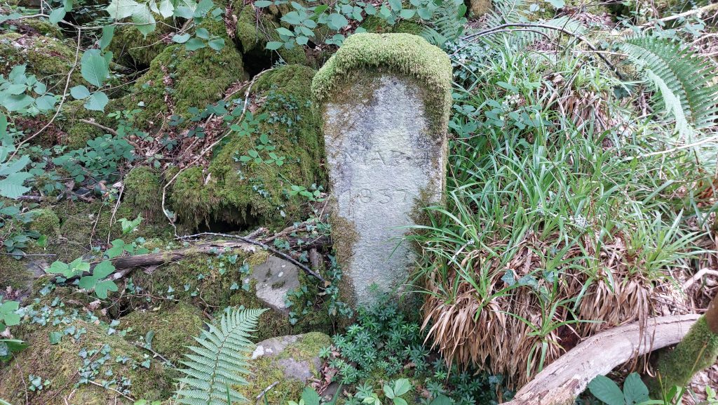
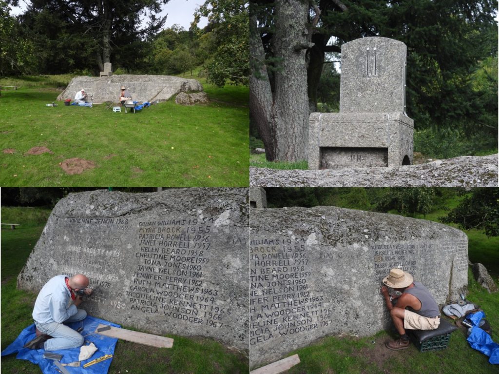
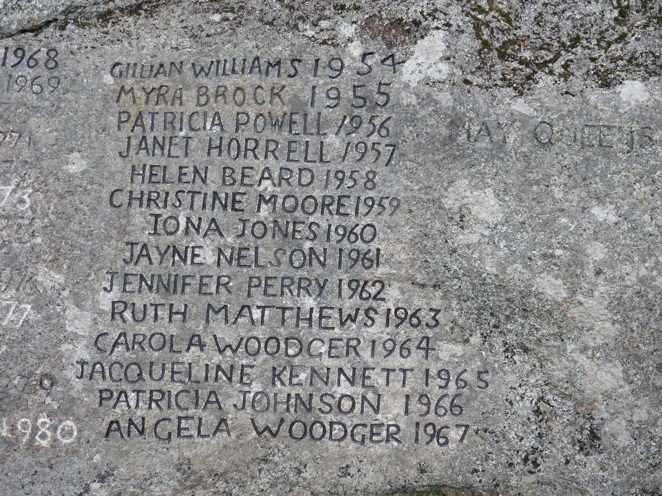
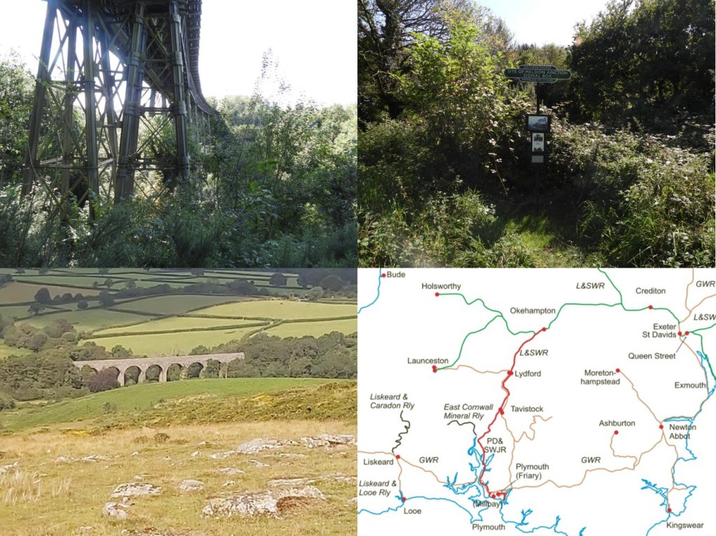
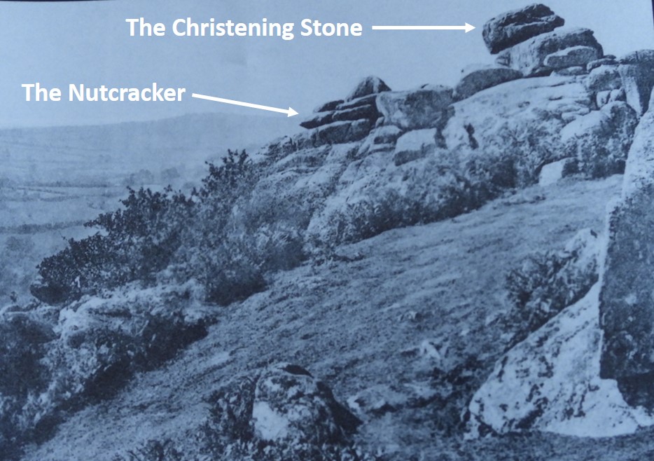
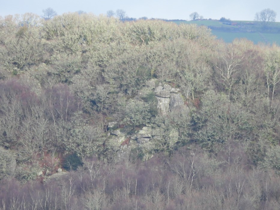
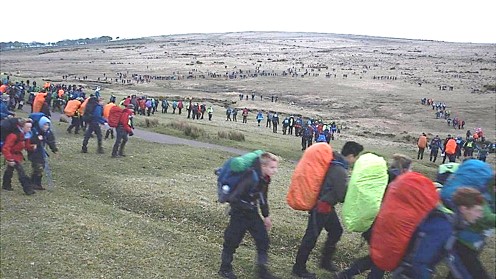
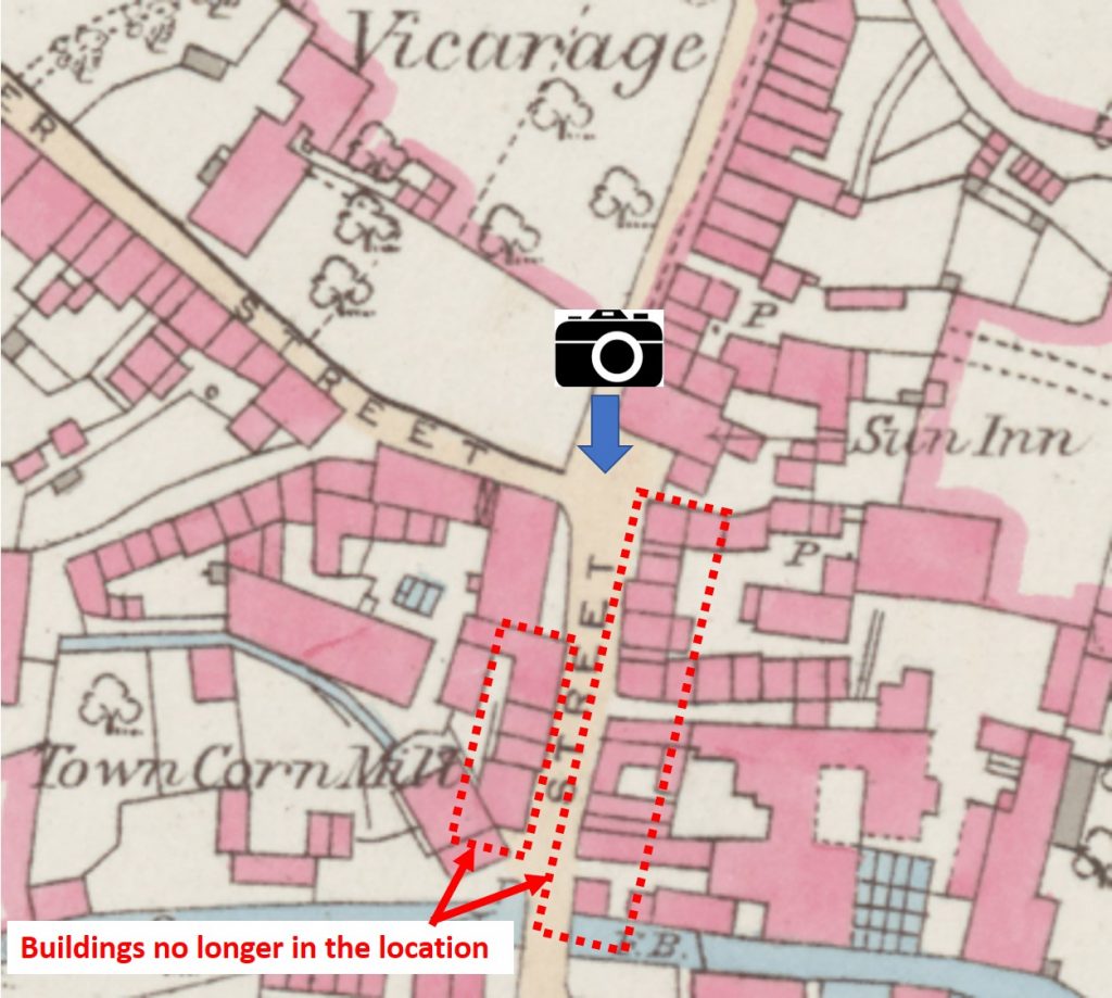
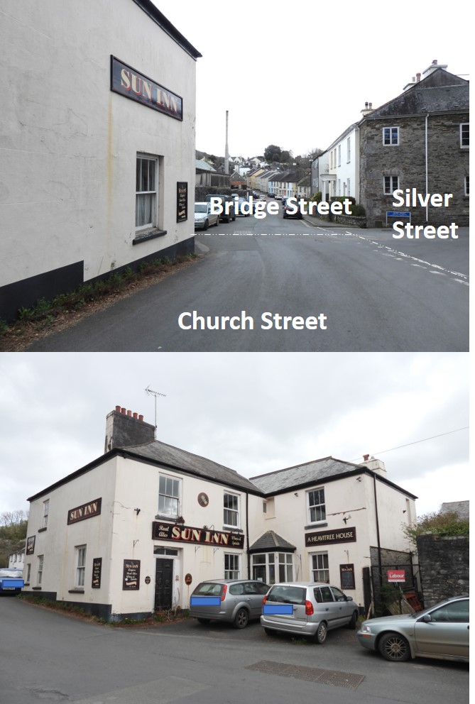
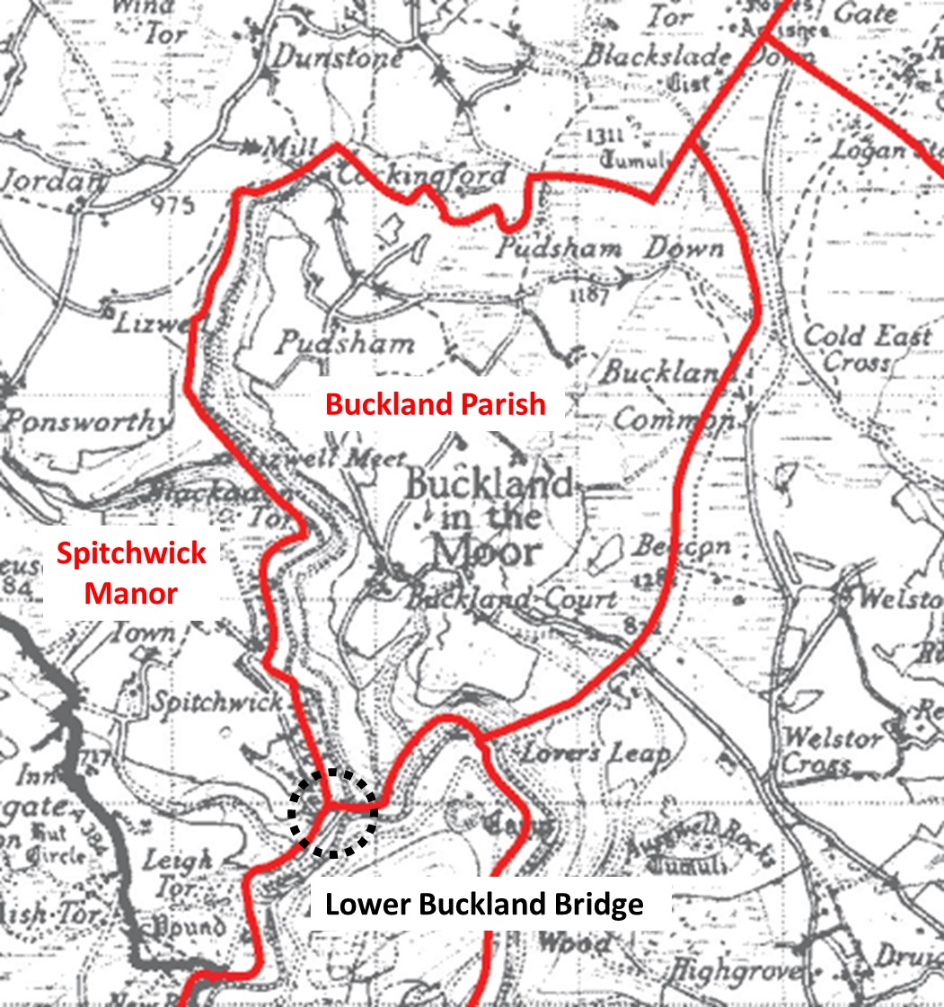
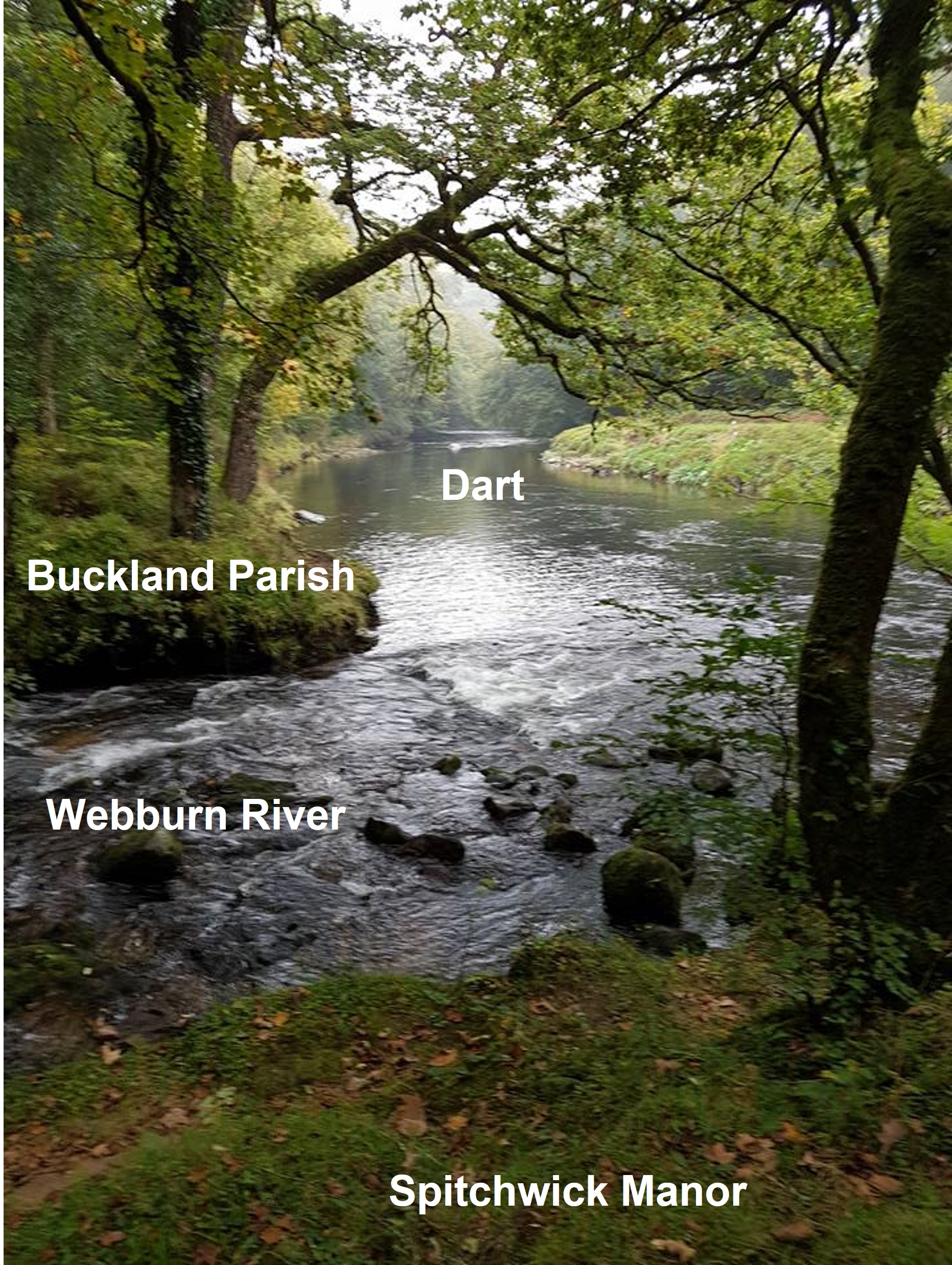
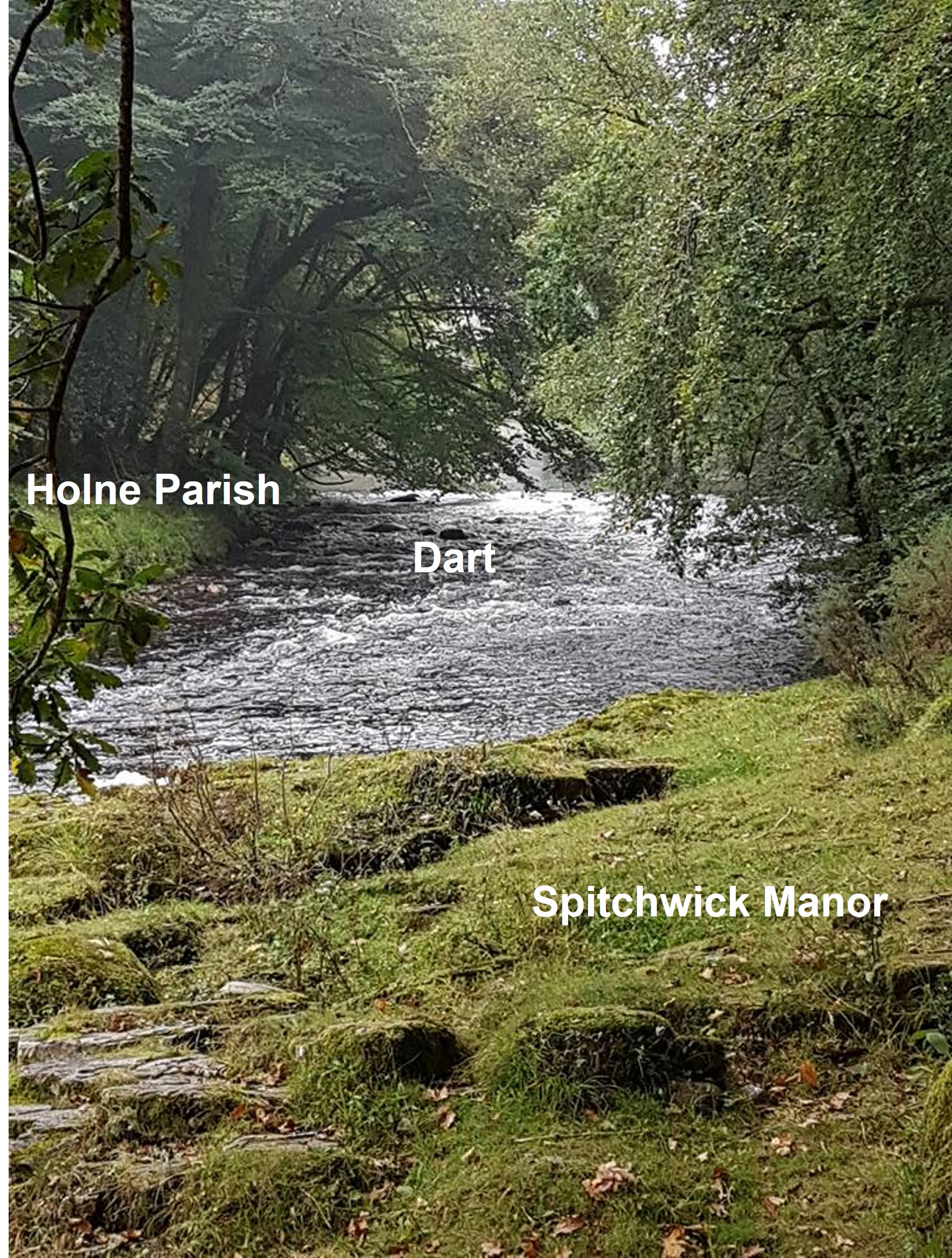
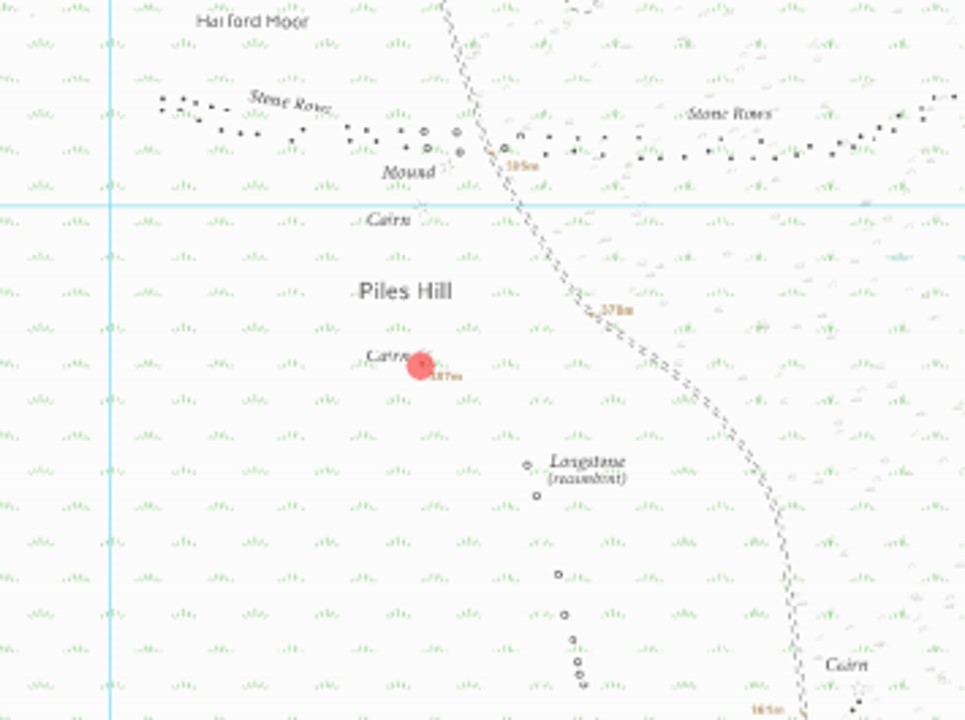
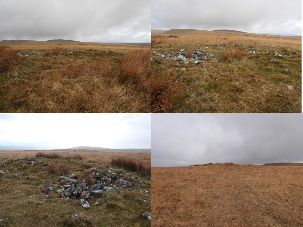
4th May 1837: Two new boundary stones were erected during a view of the bounds of Buckland-in-the-Moor. The above stone is located at SX72666 72254 near Lover’s Leap on the River Dart4th May 1837: Two new boundary stones were erected during a view of the bounds of Buckland-in-the-Moor. The stone is Inscribed with an ‘a’ and ‘b’ on opposing faces with the main face inscribed ‘MAY 4th 1837’ (albeit the ‘MAY’ does look like ‘MAR’).5th May 1962: The Lustleigh May Queen was Jennifer Perry. Traditional May Day celebrations in England can be traced back to Roman times. During the middle ages, it was customary to go “a-maying” early in the morning to collect fresh flowers with which to crown the “fairest maiden in the village”. It is believed Lustleigh probably held its own ceremony during these times but it lapsed until early 20th Century. Cecil Torr, who lived in Wreyland (Long Tor Farm), revived it in its present form and was conducted on his land from 1905 to 1940. Cecil Torr wrote: “ There is a May Day festival here, for which I am responsible. There used to be dancing around the Maypole at the Flower Show and other festivals but none upon May Day itself: and I put an end to that anomaly“. Source: https://www.lustleigh-society.org.uk/lustleigh-may-day-a-history/5th May 1962: The Lustleigh May Queen was Jennifer Perry. The celebrations at Long Tor Farm, Wreyland stopped in 1940 and between 1941 and 1953 there wasn’t a May Day Queen. In 1954, the celebrations moved to the current location at Town Orchard, where there was a suitable rock for the crowning ceremony. Newspaper reports at the time tell of large amounts of granite being blasted out of the ground in order to create a flat space for the Maypole dancing to take place. The pictures show the names and dates of the May Queens from 1954 through to 2019 being cleaned, lightly chiselled out and re-painted (September 2020).6th May 1968: The last train to run on the London and South Western Railway, between Lydford Junction to Okehampton was on this date. Source “The Dartmoor Diary 1991” by DNPA. The collage picture shows; Meldon Viaduct (top left), Lake viaduct (bottom left), Location of Meldon signal box (top right) and map of Devon railways (bottom right). 6th May 1935: A beacon fire, one of a chain was lit on Buckland Beacon by the parishioners of Buckland-in-the-Moor in celebration of their Majesties’ (George V and Mary) Silver Jubilee. The inscription on the rock describing the event is now rather difficult to discern. There is a clearer picture on the Dartmoor Trust website6th May 1935: A beacon fire was lit on Buckland Beacon in celebration of their Majesties’ (George V and Mary) Silver Jubilee. The inscription on the rock reads: 1282 FT BUCKLAND BEACON A BEACON FIRE ONE OF A CHAIN WAS LIT HERE BY THE PARISHIONERS OF BUCKLAND-IN-THE-MOOR IN CELEBRATION OF THEIR MAJESTIES SILVER JUBILEE MAY 6TH 1935 AND ALL THE PEOPLE SHOUTED AND SAID GOD SAVE THE KING6th May 1935: A beacon fire was lit on Buckland Beacon in celebration of their Majesties’ (George V and Mary) Silver Jubilee. The inscription on the rock is very easy to reads on this photograph.6th May 1950: The nutcracker logan stone at Lustleigh Cleave was reported to have been toppled by unscrupulous vandals. In fact, the nutcracker rock hadn’t been toppled but its near neighbour, the Christening Stone (so named as it had a series of hollows, which collected water, which is reputed to have been used by parishioners for Lustleigh christenings). The group of rocks were collectively known as Nutcracker Rocks. The story made both local and national papers of the day. The gentleman in the picture is rocking the nutcracker. Source: Dartmoor Magazine #58, Spring 2000.6th May 1950: The nutcracker logan stone at Lustleigh Cleave was reported to have been toppled by unscrupulous vandals. The Royal Artillery attempted to re-instate the rock (which had fallen 20ft) in June 1950. The attempt failed and the rock fell further down the valley. In August an attempt was made to replace the logan with a new one, but that too failed.6th May 1950: The nutcracker logan stone at Lustleigh Cleave was reported to have been toppled by unscrupulous vandals. The name Sharpitor Nut Crackers (Logan Stone) still appears on OS maps. It was once clearly visible from the path above, but the whole tor is now well hidden in trees and can best be viewed from across the valley at Trendlebere Down.7th May 2016: The 56th Ten Tor event started at 07:00 on this day. The first Ten Tors expedition took place in September 1960.7th May 2016: The 56th Ten Tor event started at 07:00 on this day. 400 teams of 6, making 2,400 teenagers – mostly school and youth groups from across the South West took part in the event, covering routes of 35, 45 and 55 miles over two days. In 2013, there was a major overhaul to the event with fewer river crossings to reduce the need for air support in bad weather.7th May 2016: The 56th Ten Tor event started at 07:00 on this day. From around February / March, it is quite common to see teams training. The picture above is from March 2019 and shows a ten tors group on the skyline above Taw Marsh.7th May 1883: Mayor’s Monday was celebrated on this day in Bovey Tracey. Some years previously the residents and the neighbouring farmers were accustomed to turn out en masse in honour of the occasion. Processions were formed chiefly by persons on horseback, who would perambulate the whole boundary of the parish, led by bands of music. Source: The Dartmoor Diary 1991 by DNP.8th May 1945: VE Day celebrations on Church Street / Bridge Street outside the Sun Inn, Buckfastleigh. On 7th May, the formal act of military surrender was signed by Germany, ending the war in Europe. The next day celebrations broke out all over the world to mark Victory in Europe (VE Day). In Britain, Churchill marked the occasion by declaring 8th May a public holiday.8th May 1945: VE Day celebrations on Church Street / Bridge Street outside the Sun Inn, Buckfastleigh. The view of the same location with old picture superimposed. There have been quite a number of changes with many buildings no longer in the area. However a good point of reference to compare the pictures is the canopy on the building (number 10 – Bridge Street called Laurel House) at top right of the black and white image.8th May 1945: VE Day celebrations on Church Street / Bridge Street outside the Sun Inn, Buckfastleigh. Approx location of the original photograph at the junction of Church Street, Bridge Street and Silver Street. Note: Bridge Street appears to be a relatively new name as old maps show the street to be called Market Street. Today, Market Street appears to be just south of the River (Mardle).8th May 1945: VE Day celebrations on Church Street / Bridge Street outside the Sun Inn, Buckfastleigh. Today the former Sun Inn looks a little forlorn.9th May 1919: Princetown became a separate parish in its own right, as per this Order in Council published in the London Gazette on this date. Source Mike Brown Guide to Dartmoor CD. In the paper, it recited the geographical limits of the new parish: “The territory to be annexed to the New Parish of St Michael and All Angels, Princetown…All that portion of the Parish of Walkhampton…bounded upon part of the west partly by the Parish of Whitchurch and partly by the Parish of Peter Tavy…upon the north-west by the last-mentioned Parish, upon the north-east by the said Parish of St Michael…and on the remaining sides…by an imaginery line commencing at the point which divides the said New Parish of St Michael…from the said Parish of Walkhampton crosses the middle of the road leading from Princetown to Plymouth…..”9th May 1919: Princetown became a separate parish in its own right, as per this Order in Council published in the London Gazette on this date. In the paper, it further recites the geographical limits of the new parish: “…..and extending thence south-westward along the middle of the said road for a distance of 40 chains or thereabouts to the centre of Devil’s Bridge, which carries the said road across the River Meavy, and extending thence first north-eastward, then eastward, and then northward along the middle of the River Meavy and of the western branch of such river for a distance of 22 chains…to the centre of the bridge which crosses the Princetown branch line of the GWR……..”9th May 1919: Princetown became a separate parish in its own right, as per this Order in Council published in the London Gazette on this date. In the paper, it further recites the geographical limits of the new parish: “…and extending first south-westward, then westward, then again south-westward, and then north-westward along the middle of the said line of railway to a point due east of the trigonometrical point of the OS at a height of 1,314 feet at or near the summit of King’s Tor, and extending thence…in a straight line due north for a distance of 52 chains or thereabouts to a point in the middle of the road leading from Moretonhampstead to Tavistock at a distance of 1 chain…..”9th May 1919: Princetown became a separate parish in its own right, as per this Order in Council published in the London Gazette on this date. In the paper, it further recites the geographical limits of the new parish: “……..east of the milestone indicating 15 miles to Moretonhampstead and 5 miles to Tavistock, and…then north-westward, then south-westward and then northward along the middle of such road to the centre of Merrivale Bridge…”10th May 1975: Sir Henry Slesser opened a new mobile information centre in the square at Princetown. This was to be his last duty as Chairman of the Dartmoor National Committee. He would have been in his early 80’s at that time. The centre at that time was a specially designed caravan, which one suspects may have been a similar size to the information centre at New Bridge shown in the picture above. During its time in the square the information centre attracted 2646 visitors in the following 21 weeks. For the following year the centre was moved to Two Bridges for a trial period. The picture of Sir Henry above was taken in 1924. I wonder if he could have imagined the 21st century centres we have today. The picture of Princetown in the snow was taken early February 2019.11th May 1958: Fice’s Well stone wall surround restored. Men of the 571 Construction Squadron, Royal Engineers, Territorial Army from Raglan Barracks, Devonport worked on the restoration. They also assisted in the restoration of a clapper bridge over the Blackabrook. The “modern” wall structure around the well is believed to have been built by Dartmoor prisoners in the 19th Century. Inside is the stone covered spring and on the lintel stone is carved ‘I.F. 1568’, standing for John Fice.11th May 1931: A moth aircraft crashed in thick fog 300 yards from Crazywell Pool. The crash is thought have happened due to a faulty compass. The pilot (a Mr Cardon) was unhurt and managed to walk to Sheepstor having followed Newleycombe Lake down to Norsworthy Bridge. He arrived at the home of the parents of Basil Hutchinson. Source: Letters page (Basil Hutchinson) from Dartmoor Magazine #16, Autumn 1989.11th May 1931: A moth aircraft crashed in thick fog 300 yards from Crazywell Pool. At Sheepstor, telegrams were sent off and after a meal and change of clothes, Mr Cardon went by taxi to Plymouth, then caught the midnight train to London. His plane was entrusted for care to the Hutchinson’s. Apparently both wheels of the plane had been forced into the wings by the force of the impact but otherwise damage was surprisingly slight. It is not known to the author, the precise location of the crash, but looking at contours on a map and the topography of the ground, it is possible landing south west of the pool offers flat ground. The ground north or south of the pool is a little steeper.11th May 1931: A moth aircraft crashed in thick fog 300 yards from Crazywell Pool. The story continues after two days from the crash when two men turned up from the Croydon School of Flying with a lorry (presumably they were able to get close to the crash site). They dismantled the plane and took it back to London by road. Basil Hutchinson concluded the story by saying that he believed the plane flew again and in fact was entered to fly in the King’s Cup Air Race in the June of that year.11th May 1983: The National Park Authority purchased Plasterdown, 232 acres from the Ministry of Defence in order to re-instate the site of the former camp back to moorland. Source: The Dartmoor Diary 1991 by DNP.11th May 1993: On this date, a new Duke Stone at SX74523 77192 was erected by Dartmoor Preservation Association, in memory of F.H (Harry) Starkey and has his initials FHS near the base on the side which is also inscribed DS 1853. The original stone on the Ilsington / Manaton parish boundary, was erected in 1853, “to the memory of the present Lord of the Manor” (Edward Adolphus, The Duke of Somerset). The original stone is believed to have gone missing in 1938.12th May 1990: Marriage Blessing took place at Keble Martin Chapel. Conducted by Rev. Eric Carless, the marriage of Derek Newman and Caroline Atchley was blessed on this date. The groom had camped out overnight so as to arrive at the “chapel” on time. The bride had to, however walk in from Lud Gate in her wedding dress and walking boots. Some of the guests arrived by Land Rover, courtesy of a local land owner. They had a reception at Hayford Hall. Information taken from Dartmoor Magazine Issue 20, Autumn 1990.12th May 1990: Marriage Blessing took place at Keble Martin Chapel. The Chapel is at ‘Mattins Corner’ and was built in 1903 by Rev Keble Martin and his companions. Ironically it is located at SX666 666. The cross was incised by Arthur Martin. Of note is that Rev Keble Martin, wrote the book The Concise British Flora in Colour, which is beautifully illustrated.12th May 1990: Marriage Blessing took place at Keble Martin Chapel. The wooden plaque at the chapel reads: “Keble Martin open air Chapel 1903, divine worship last held here 11 July 1982 text “thou God seest Gen 16:13”12th May 1986: The National Park began making considerable structural repairs to St. Lawrence Chapel in Ashburton. The pictures were taken on Easter Monday, 2021.12th May 1986: The National Park began making considerable structural repairs to St. Lawrence Chapel in Ashburton. The plaque at the entrance gates states the chapel dates back to 1314, was a lawful meeting place of the annual courts since 1593 and was a grammar school until 1938. 12th May 1937: King George VI coronation. This commemoration stone can be found on the green at North Bovey.13th May: South Brent traditionally had two fairs (13th May and 10th October), known as Lamb Fair and Goose (or roast goose) Fair. These dates are from late 18th century. Prior to this the dates were in April and September. At these fairs, sheep, cattle and ponies were traded. The Black and White picture shows a horse fair at South Brent Station c. 1900. It is recorded that windows in the town were barricaded during these fairs due to the horned cattle and ends of old iron bedsteads used to block doorways against straying sheep.13th May 1808: On this date a Mr Matthew Crawford and a Lt Col Richard Fleming took out a 99 year lease to build both Teignhead and Manga farms for them to be built within 10 years. The lease was for 1551 acres (reduced later to 904) and the annual rent was £58 3s 11d (about £5,300 today). The building of the was overseen by a Mr William Rogers, who was the agent for Crawford and Fleming. It is believed that Manga farm with its thatched roof was abandoned in the 1870’s.13th May 1808: On this date a Mr Matthew Crawford and a Lt Col Richard Fleming took out a 99 year lease to build both Teignhead and Manga farms for them to be built within 10 years. In the Dartmoor HER (SDV269516) it is stated that Manga Farm “lies on a slight shelf on the steep east facing slope of Manga Hill. The remains comprise a 3-roomed dwelling and two small enclosures. Positioned along the slope the structure measures 14 metres north to south by 3.8 metres internally with boulder walls 0.6 metres thick and up to 2 metres high”. William Crossing sited the farm (which he called Mandles) on Great Varracombe. In the Dartmoor HER, F.H. Starkey states this is in error – but is this the case ? On the original lease map the farm was built on was then known as Great Varracombe (not Manga Hill as it is today). Little Varracome was on land to the south. Early (pre-1829) records suggest the farm was called Varracombe. Of course, today Great and Little Varracombe’s are attributed to brooks only and not to tracts of land. Was the farm renamed due to its proximity to other things “Manga” (ie brook, falls, hole and rock) ? 13th May 1808: On this date a Mr Matthew Crawford and a Lt Col Richard Fleming took out a 99 year lease to build both Teignhead and Manga farms for them to be built within 10 years. A small linhay is attached to the south wall. It is referred to as a Turf House by Elisabeth Stanbrook in a Dartmoor Magazine article from Autumn 2002. 13th May 1808: On this date a Mr Matthew Crawford and a Lt Col Richard Fleming took out a 99 year lease to build both Teignhead and Manga farms for them to be built within 10 years. F.H. Starkey (1978-1981) states : “Farmhouse circa 12 metres by 4 metres with three rooms”. The south room is suggested by some as the kitchen and the centre room being the main living area and where the entrance was on the east side. In a Dartmoor Magazine article (from Autumn 2002), it suggests that the northern most room was a bedroom. Confusingly, the Dartmoor Magazine article also states there was a cowshed to the north with a drainage channel which can still be seen. So, if this is the case there would have been “four” rooms / cells, namely; south room (kitchen), centre room (living area), north room (bedroom) and cowshed. The confusion is that the Dartmoor HER only refers to three rooms. 13th May 1808: On this date a Mr Matthew Crawford and a Lt Col Richard Fleming took out a 99 year lease to build both Teignhead and Manga farms for them to be built within 10 years. The pictures are on Teignhead Farm which was occupied until 1943 when it was requisitioned by the war office. A picture by Robert Burnard from August 1889 can be found on the Dartmoor Trust Archive here: https://dartmoortrust.org/archive/record/322314th May 1971: On “Low Man” (the western outcrop of Haytor) there is a climbing route called “Rhinoceros” . In June 1968, Jim Collins climbed pitch 1 – (known as Aviation direct at the time) and the second pitch was added by Pat Littlejohn on 14th May 1971, who gave it the name.14th May 1971: The “Rhinoceros” climbing route on Low Man (Haytor), the second pitch was added by Pat Littlejohn on this date, who gave it the name. The picture is Low Man taken from the south side, zoomed in from near Bag Tor.14th May 1988: St Lawrence May Fair, Ashburton was held, to mark the official opening of the chapel to the public. The date was close to the 2nd anniversary of the National Park starting extensive restoration works on the building.15th May 1891: D company 4th volunteer battalion, Devonshire Regiment held a shooting competition at Ivy Tor Rifle range. Looking at an old map, the rifle range had a target and 600 yards point clearly marked. Today, evidence of the target and the 100 & 400 shooting platforms remain.15th May 1891: D company 4th volunteer battalion, Devonshire Regiment held a shooting competition at Ivy Tor Rifle range. Target remains today, believed to have been made by Bodley foundry in Exeter. This is a three sided “Mantlet”. Each part has incised markings. When operational the mantlet would have been vertical and the target operator would have stood up inside for protection ! This is at SX62766 9352815th May 1891: D company 4th volunteer battalion, Devonshire Regiment held a shooting competition at Ivy Tor Rifle range. The picture is Skaigh House (known as Rockside in 1891). A write up in Western Morning News, 15th May 1891, regarding the shooting competition makes fascinating reading, viz; “Mr J Byres Leake came to the range about noon, and invited all the competitors to Rockside to refreshment at the close of shooting, which kind offer was gladly accepted by the men. The shooting being over, the members retired to Rockside, where the prizes were distributed by Mrs Byres Leake.” The article further states: “The men were then shown over Rockside, including the hot-houses, billiard room, stables etc. This done they all entered the conservatory, where refreshments were handed around. Before marching off the men gave Mr and Mrs Byres Leake three hearty good cheers”. 16th May 1970: Great Mis Tor struck by lightening. Local newspapers reported that the tor had been hit with such ferocity that granite boulders were cut in half and fragments were strewn over a wide area.16th May 1902: The bounds of Spitchwick Manor were perambulated, the event lead to a rebuke by Buckland-in-the-Moor over Spitchwick’s claim to rights over the whole (width) of the Dart. Of interest, is that the boundaries between Spitchwick and Buckland only meet the Dart at one single point. This point is a few 10’s of metres below Lower Buckland Bridge where the Webburn enters the Dart. So why the rebuke, if the two do not share the Dart as a boundary ?16th May 1902: The bounds of Spitchwick Manor were perambulated, the event lead to a rebuke by Buckland-in-the-Moor over Spitchwick’s claim to rights over the whole (width) of the Dart. A steward from Bucklan-in-the-Moor is recorded as saying: “Mr Bastard [Lord of the Manor] desires me at once to inform you that he entirely repudiates such a claim….when the Ordnance map was made some years ago…Mr Bastard substantiated his claim which rights up to that time had been undisputed and have not since been in question”16th May 1902: The bounds of Spitchwick Manor were perambulated, the event lead to a rebuke by Buckland-in-the-Moor over Spitchwick’s claim to rights over the whole (width) of the Dart. One assumes the boundary of the Webburn River that Spitchwick and Buckland share wasn’t disputed and effectively the boundary is in the middle of the river. The next Spitchwick Manor bounds perambulation didn’t take place for 22 years (17th May 1924), an account of the event is recorded here: https://www.legendarydartmoor.co.uk/2017/01/01/spitchwick-manor/16th May 1902: The bounds of Spitchwick Manor were perambulated, the event lead to a rebuke by Buckland-in-the-Moor over Spitchwick’s claim to rights over the whole (width) of the Dart. As Spitchwick had claims over the Dart, one would assume that the parish of Holne would have had more cause to complain than Buckland as their boundary actually abuts the Dart (upstream from the Webburn in direction of Deeper Marsh)17th May 1956: Cairn on Piles Hill was first registered on Historic England website on this date. Note from the map it states that the nearby Longstone is recumbent. It has now been re-erected.17th May 1956: Cairn on Piles Hill was first registered on Historic England website on this date. The registration was 1012474. On the website is describes the cairn thus: “This very large cairn, 32 m. in diameter, is situated on the summit of Piles Hill. It consists of a central mound, 1.5 m. in height, on a stone and earth platform, with a 3 m. wide berm extending beyond the circumference of the mound and a bank of stones surrounding the whole monument. It is considered to be a variant of the Wessex Bell Barrow type”.17th May 1956: Cairn on Piles Hill was first registered on Historic England website on this date. The picture taken from the north west shows the 3m berm.17th May 1956: Cairn on Piles Hill was first registered on Historic England website on this date. The picture taken from the south shows the 3m berm.18th May 1977: Major fire at Standon Farm. The picture is of the front of Standon Farm with the old farmhouse on right and the new farmhouse (where the fire took place) on the left.18th May 1977: Major fire at Standon Farm. The picture shows the remains of the new farmhouse wall. Plans to rebuild were just too expensive. Through a facebook post, the author received a reply from Alec Phillpott of Brousentor : “I reported this fire to Tavistock fire service. It took them three quarters of an hour to get here. The Princetown crew were first to arrive. Two marines were in residence and decided to light fire with petrol from jerrycan. The house had about fifty beds all with rubber matresses so was quite an inferno. The debris from the fire was conveyed to Tavistock Crowndale dump”. More information can be found in the report “STANDON FARM PETER TAVY an historical and archaeological survey” by Dr Tom Greeves.18th May 1977: Major fire at Standon Farm. The Old Farmhouse has, just to the right of the lower left window, a date plaque. This farmhouse is likely to be on the site of an early, very possibly medieval, dwelling. (Source: “STANDON FARM PETER TAVY an historical and archaeological survey” by Dr Tom Greeves.)18th May 1204: King John granted a charter to disafforest Devonshire ‘up to the metes and bounds of Dartmoor’. He was making a desperate attempt to raise funds for an army for a war with King Phillip of France, by giving up his rights in Devon but retaining the highlands of Dartmoor. It is believed it raised 5000 marks for the crown. In those times the term “forest” in this context was crown land, reserved for hunting comprised trees, turf and vegetation, where hunting would have included deer, hare, rabbit, pheasant, boar, wolf, fox, martin, partridge, quail, heron and mallard.18th May 1204: King John granted a charter to disafforest Devonshire ‘up to the metes and bounds of Dartmoor’. The boundary was important as revenue could be derived from activities within the forest. King John failed (as with Saxon and Norman tradition) to order a “perambulation” to seal the boundary lines. However, in spite of this, it was not until his son, King Henry III came to the thrown that the first perambulation of Dartmoor was secured, this was in 1240. 19th May 1921: Edward, Prince of Wales toured Dartmoor on this date. Various reports state he stayed at either Duchy Hotel (The Times) or Princehall (Okehampton Times). He was reported to have travelled by horseback as part of a hunt to Fernworthy Farm (where he met one of his duchy tenants); the route was via Bellever Tor. At 1300, he was guided on foot to Cranmere Pool, where he arrived at 1430. He then went onwards to Rattlebrook Peat Works. The return trip, as is intimated in Okehampton Times was via Bridestow Station (which one would assume he didn’t walk to).19th May 1921: Edward, Prince of Wales toured Dartmoor on this date. According to the Okehampton Times: “He (Edward) must, however, be the only member of the Royal Family to walk to Cranmere Pool. In a distinguished group of seven people, he made the pilgrimage accompanied by Sir Walter Peacock, Admiral Sir Lionel Halsey, Mr William Proudfoot, Lord Clinton, Mr Jim Endacott and Mr Raleigh Philpotts. There were two extra members: one was an intrepid unnamed reporter from the Western Morning News who, presumably, carried the heavy camera equipment and certainly deserved a scoop. The heir apparent observed, after he tested the weight of the equipment, you deserve fifty photographs for carrying this ten miles. The other was William Rich, a Dartmoor worthy of his time, redoubtable, garrulous, expert moorsman and with his sturdy thickset figure and his white beard he was a familiar sight. William Rich acted as his guide to Cranmere Pool and to a visit to the Rattlebrook Peat Works.” Interestingly, the DNPA Dartmoor Diary from 1991, states that he was guided to Cranmere Pool by J. Endacott and the Times only mention four of the party (and also states William Rich, who was 76, only met the Prince at Rattlebrook Peat Works). 20th May 1737: An entry in the Holne Churchwardens’ accounts, records that on this day the parishioners agree that there shall be an allowance to killing foxes 10/6. This was at a time when payments for the destruction of vermin, including foxes, badgers and martins, came out of the church rate. The collage shows the Church (top left and bottom right), Church House Inn (bottom left) and village farm (top right).21st May 1830: This date was day three of Miss (Sophie) Dixon’s Ten days excursion of the western and northern borders of Dartmoor. Her 81 page journal (see picture) is a fabulous read and a wonderful insight into the early 19th century Dartmoor excursions. Day three (Friday 21st May) started at 05:00 and her route with her companions was (as far her description allows the author to follow): Brent Tor, Lydford (for breakfast stop), Cate’s Mine, High Down, Great Nodden, Great Links Tor, West Okement Valley, Meldon quarry and finally Okehampton, which was reached about 16:30. Miss Dixon described it as a walk of around 28 to 30 miles.21st May 1830: This date was day three of Miss (Sophie) Dixon’s Ten days excursion of the western and northern borders of Dartmoor. When the group left Lydford after their breakfast, they made their way to the “Turnpike Road”. The journal describes having passed Cate’s Mine “a shaft of recent date” en-route. The mine has been known by many names over the years, including Kitts (as shown on the map). The mine closed a few years later after this excursion. Miss Dixon would not have seen the London and South Western Railway bridge crossing the Lyd or Skit Bridge, which the modern A386 passes over crossing the Lyd. Miss Dixon would have used the old Tavistock Turnpike Trust Road.21st May 1830: This date was day three of Miss (Sophie) Dixon’s Ten days excursion of the western and northern borders of Dartmoor. The pictures depict part of Miss Dixon’s journey from her descriptions. She describes following the old Turnpike Road (now A386) “until it diverged by a steep lane”, which one assumes is the lane to Lydford High Down next to the Dartmoor Inn. It is possible that she took Skitt Lane to High Down Farm, but the author thinks this unlikely from the description.21st May 1830: This date was day three of Miss (Sophie) Dixon’s Ten days excursion of the western and northern borders of Dartmoor. Miss Dixon’s route from High Down is a little open to interpretation. That said, she mentions “Great Nodden, Woodcock Hill, Great Lynch (sic) Tor, then towards Sourton Tors, West Ockment (sic), Black Tor and Meldon quarry”. Of course Meldon reservoir would not have been built for another 142 years. The journal at the end of this days excursion says “the largest proportion of which was over hills, where the wind blew with such violence that we had extreme difficulty to proceed at all”.22nd May 1979: The National Park Authority negotiated public access to woodland at Becky Falls. This agreement also assured future management of the woodland in the area. The picture is an old clapper in the woodland en-route to Lustleigh Cleave.22nd May 1979: The National Park Authority negotiated public access to woodland at Becky Falls. The footpath through the area southwards from Freeland / Water to Lustleigh Cleave is very picturesque.22nd May 1956: The North Hessary Tor mast was officially opened. In August 1951, when the BBC announced their proposals, North Hessary standing at 1696 ft (517m) above sea level, was deemed the only suitable place for a 5kW television station / mast for maximum coverage of 405 line television to serve Plymouth, Torquay, Exeter and East Cornwall. It was built in 1955 and must have been very controversial for the fledgling National Park. The pictures show the access road under construction c1955 (note the temporary caravans) and the road in July 2019. 22nd May 1956: The North Hessary Tor mast was officially opened. The original mast was designed and constructed at 750 ft (230m) tall, so the height above sea level easily made it the highest point in Devon. It was a repeater station with TV pictures coming from Wenvoe, Cardiff in South Wales and the sound coming direct Post Office cable. At a meeting, in June 1952, the Dartmoor National Park Committee recommended (by the chairman’s casting vote) that DCC (Devon County Council) should grant planning permission. Apparently, Sylvia Sayer, DNP Committee member walked out in disgust. The pictures show various points of the construction and are c1955.22nd May 1956: The North Hessary Tor mast was officially opened. In 1953, after much debate and consideration for alternative sites (including King Tor, put forward by Sylvia Sayer), it was decided to hold an inquiry. This started on 29th September in Exeter. In 1954, the BBC announced they would start work as soon as possible and the mast and station would be ready by the end of 1955. Today, the mast stands at only 600 ft (183 m), as it was shortened for structural reasons in March 1987. The mast, today is used for FM transmissions as well as being a TV signal relay. 22nd May 1859: Birth date of Sir Arthur Ignatius Conan Doyle. The BBC 2012 modern take on the famous Conan Doyle book, ‘Hound of the Baskervilles’ included scenes of Hound Tor. He passed away on 7 July 1930.23rd May 1895: James Perrot, the well known Dartmoor guide and father of letterboxing died on this date. James Perrott was born in March 1815 at Coombe (according to devonperspectives.co.uk) or at Thorn Farm (according to Dartmoor Magazine #38). Both locations are close to Chagford to where he moved at an early age and remained until his death in 1895.23rd May 1895: James Perrot, the well known Dartmoor guide and father of letterboxing died on this date. James began his working life as a wheelwright but then diversified into making and selling fishing tackle from a small shop in Chagford Square. His shop was next to the Ring of Bells Inn. Gradually his business empire expanded and added to through his guiding services and the hiring of saddle horses/ponies and carriages. In his later years he spent most of his time in his small shop in Chagford Square. He married Mary Harvey (from Yardworthy) in October 1839 and they had four sons and four daughters. His eldest son, Richard (Dick) assisted with the businesses.23rd May 1895: James Perrot, the well known Dartmoor guide and father of letterboxing died on this date. He is probably best known today for having established the first Dartmoor letterbox. In 1854, he built a small cairn at Cranmere Pool in which he placed a bottle. The idea was that visitors could leave their calling card. A visitor’s book was added later. Various free-standing containers were used for the cards at different times until in 1937, following an appeal by the Western Morning News, a permanent stone box with a door was built. The picture above was taken in August 2013 and is Steve, the author of this website and Debbie of DW Research and Archive Services (https://www.dwresearchservices.co.uk/). 23rd May 1895: James Perrot, the well known Dartmoor guide and father of letterboxing died on this date. During his life, James Perrott became close friends with many well-known West Country writers including novelists Charles Kingsley and R D Blackmore. Writing about him in 1895, J.W.Page wrote: “James Perrott, the well known guide, the best living authority on that land of tors, of which he is, indeed, a veritable ‘walking cyclopaedia.” Furthermore, he was described as: “Rugged, frank and of cheery disposition, his sterling worth caused him to be respected by those who made his acquaintance” as written by William Crossing about James Perrott in his series of articles published in the Western Morning News. His final resting placed is in the churchyard of St. Michael the Archangel, Chagford, where his gravestone can be easily found.24th May 1909: The Western Morning News published the first edition of William Crossing’s Guide to Dartmoor. Apart from the Guide, Crossing wrote books about the antiquities and folklore of Dartmoor, as well as poetry and plays. These included: One Hundred Years on Dartmoor, Gems in a Granite Setting, The Ancient Stone Crosses of Dartmoor, and a collection of personal memoirs of his rambles on the moor, Amid Devonia’s Alps. 24th May 1909: The Western Morning News published the first edition of William Crossing’s Guide to Dartmoor. William Crossing’s passing was honoured by the Dobson’s Moormen walking group who attached a plaque to a boulder at Duck’s Pool that reads: In memory of William Crossing, author of many inspiring books on Dartmoor, whose Guide is a source of invaluable information to all lovers of the moor. Died 3rd Sep. 1928, aged 80.24th May 1909: The Western Morning News published the first edition of William Crossing’s Guide to Dartmoor. Crossing needed an illustrator for the Guide and obtained the services of one Philip Guy Stevens, the boyfriend of the daughter of the landlord of the Duchy Hotel in Princetown. Philip worked at Dartmoor Prison as an administrator, as well as having some artistic talent and a knowledge the moor. Crossing would ask him for a particular view which often entailed the artist making a 10 mile round trip starting out at 5am before beginning his day-job at the prison. The picture above is a comparison of a typical Stevens illustration of Grimspound (from Warren House Inn) and a photograph from the same location (taken in July 2020).24th May 1909: The Western Morning News published the first edition of William Crossing’s Guide to Dartmoor. In July 1925, William was no longer able to cope on his own and was moved to a Tavistock Institution; some time later he was moved to a private nursing home in Plymouth where he remained until his death. He was laid to rest beside his wife in the churchyard of St Mary’s in Mary Tavy.24th May 1942: An Avro Lancaster 1 R5617 from RAF 207 Squadron crashed into Standon Hill during a night training exercise from Bottlesfield, Leicestershire. Of the crew, unfortunately four were killed. The picture was taken in June 2014 on top of the hill.25th May 1726: A Meavy Parish Register entry reads: “Thomas in Elford was bur’d in Woolan”. This was because of an unpopular and short-lived law which had been made to boost the woollen industry by shrouding corpses in wool. Source: The Dartmoor Diary 1991 by DNPA25th May 1975: An experimental bus service, the Pony Express, was introduced to run on Sundays and Bank Holidays through to September to cover the Bovey Tracey, Haytor, Widecombe-in-the-Moor, Hound Tor and the Becky Falls area. Source: The Dartmoor Diary 1991 by DNPA. The photographs above represent the five aforementioned locations.25th May 2001: Mike Brown’s Guide to Dartmoor CD-ROM launched. This was the product of many years of archive and field work conducted by local historian Mike Brown. With over 750 photographs, a 9500+ entry place name gazetteer and over 500k words, it was (and still is) an invaluable source of information for any Dartmoor enthusiast. 26th May 1945: Walkhampton village hall was built shortly after the Second World War in memory of those who had served in the forces. On this date, four raffles were started to help raise money for the hall; the prizes were a wheelbarrow, a pig, logs and a dartboard.26th May 1945: Walkhampton village hall was built shortly after the Second World War in memory of those who had served in the forces. On this date, four raffles were started to help raise money for the hall. The minutes of a parish meeting held in April 1944 record that “the interest of ex-Servicemen and Women would be best served by putting money towards a public hall”, and a year later that “money be raised for a parish hall in memory of those fallen and in appreciation of all serving forces in the parish”. 26th May 1945: Walkhampton village hall was built shortly after the Second World War in memory of those who had served in the forces. On this date, four raffles were started to help raise money for the hall. This inscribed granite tablet is set into the wall facing the road.26th May 1945: Walkhampton village hall was built shortly after the Second World War in memory of those who had served in the forces. On this date, four raffles were started to help raise money for the hall. A farmer agreed to give one of his fields adjoining the site, one of the very few plots of reasonably flat land within the village, for the sports field which is still used for this purpose today. The author played many seasons on this pitch in the 1990s.26th May 1808: Thomas Michelmore became the Duchy’s new tenant at Huntingdon Warren. The annual rent for the land (585 acres) and the dwelling house was £4 7s 8d (£4.38). This is around £300 today, taking inflation into account. (Source: Mike Brown’s Dartmoor 2001 – a diary of yesteryear)26th May 1726: Dame Mary Rogers of Blachford was convicted by the Archdeacon’s Court of Totnes for interfering with services at St. Michael’s Church, Cornwood and ordered to pay a fine. This was a long running issue which had begun three years earlier in 1723. She took the matter to higher courts and successfully had the judgement overturned in 1731, some 8 years after the ‘issue’ first arose, which was an argument over hat pegs !! (Source: Mike Brown’s Dartmoor 2001 – a diary of yesteryear)27th May 1986: Brook Manor is a stunning Grade II listed 17th century Jacobean manor house, which was registered on historic England website on this date. The registration number was 1168435. Described on the website thus: “Dated 1656. Stone rubble, partly slate hung and partly rendered. Bituminised turned slate roof with gabled ends. Three storeys. Now L-shaped on plan originally E-shaped but west (left hand) coving burnt down in C19. The West wing (the original central range) has three-storeyed gabled porch to right of centre with round arched doorway and hood moulds over first and blocked second floor windows”.27th May 1986: Brook Manor is a stunning Grade II listed 17th century Jacobean manor house, which was registered on historic England website on this date. Further described on the website thus: “Datestone 1656 over first floor window. To left two four- light chamfered wooden mullion windows to hall and horizontally sliding sashes above with glazing bars. Second floor blank. Large rendered external chimney stack on rear wall. South east wing projecting on right hand has slate hung west side and lean-to along ground floor. The east side of south east wing was remodelled in circa early C19 to form principal front. Two storeys and attic. Five bays. First floor slate hung. Ground floor two-light sashes with glazing bars and first floor four two-light casements. Both ground and first floor windows have dripmoulds. Four C19 gabled attic dormers. Central two storey gabled porch with round arch doorway”. 27th May 1986: Brook Manor is a stunning Grade II listed 17th century Jacobean manor house, which was registered on historic England website on this date. Richard Cabell was Lord of the Manor of Brook and was a man of very ill repute and was the subject of a local legend. It is said that on the night of his death (5th July 1677) black hounds, breathing fire and smoke, raced over Dartmoor and surrounded Brook Manor House, howling. He is buried at Holy Trinity Church, and his tomb in the churchyard (known locally as the sepulchre) was designed to imprison his remains and prevent his haunting the neighbourhood. The pictures above shows the mausoleum, overlaid with the family crest.27th May 1986: Brook Manor is a stunning Grade II listed 17th century Jacobean manor house, which was registered on historic England website on this date. Richard Cabell (the 3rd) was Lord of the Manor of Brook and at his mausoleum has a sign which provides information for the visitor. Cabell is said to have been the inspiration for Sir Arthur Conan Doyle’s, Hugo Baskerville in “Hound of the Baskerville’s”.28th May 1944: A Hawker Typhoon 1B EK211, struck the tower of St. Paul’s Church, Yelverton as it was taking off from RAF Harrowbeer.28th May 1944: A Hawker Typhoon 1B EK211, struck the tower of St. Paul’s Church, Yelverton. It was from RAF 263 Squadron. 28th May 1944: A Hawker Typhoon 1B EK211, struck the tower of St. Paul’s Church, Yelverton. The aircraft came down at Gratton Farm and the pilot was sadly killed. More information can be found at: http://www.rafharrowbeer.co.uk/photographs.htm28th May 2000: A new boundary marker was set up on the Tavistock / Whitchurch parish boundary to mark the millennium. A time capsule containing local memorabilia was buried before a large inscribed boulder was placed on top. The boulder is inscribed “TAVISTOCK TOWN BONDARY / T AD 2000 W / THE LIONS CLUB OF TAVISTOCK”. The ‘T’ (to the west) stands for Tavistock and the ‘W’ (to the east) for Whitchurch. 28th May 2000: A new boundary marker was set up on the Tavistock / Whitchurch parish boundary to mark the millennium. This boundary marker is located at SX49705 73303 and is the one of two boundary markers that the author is aware of on the 20th century boundary (the other is in Middlemoor by Tiddy Brook). The marker appears to have been located around 10 metres of so inside the Whitchurch Parish and is not exactly on the boundary28th May 2000: A new boundary marker was set up on the Tavistock / Whitchurch parish boundary to mark the millennium. According to the National Library of Scotland Maps (Side by side), on a 1949-72 map, the parish boundary just ‘clips’ the edge of the small car park located by the road as illustrated in the photograph. The author assumes the boundary marker is located where it is to avoid the car park and the rather water logged ground to the north.29th May 1976: Two Moors Way was opened. The original Two Moors Way covers 102 miles from Ivybridge on the southern boundary of Dartmoor National Park to Lynmouth on the North Devon coast in Exmoor National Park. However, many walkers now wish to complete a Coast to Coast walk and complete the Ivybridge to Wembury (on the South Devon coast) by following the Erme-Plym trail, adding around 15 miles. The pictures were all taken in February 2020. The opening date on the stone at Stowford Bridge can be easily be discerned.29th May – ‘Oak Apple Day’ : This date was a celebration to mark the return of King Charles II to England in 1660. It is recorded that Tavistock was one of the busiest towns on ‘Oak Apple Day’. I was also known as ‘Garland Day’. On this day, people were allowed to cut boughs from oak tree as long as it was done before 0600. Source: Legendary Dartmoor website.30th May 1914: Rev. Heathcote Smith, the first vicar of St. Raphael’s at Huccaby died on this date. A plaque to his memory is located inside the church, on the left hand wall when facing the Good Shepherd window. He was the vicar in 1913-4.30th May 1743: On this date, at a vestry meeting in Holne it was agreed that the churchwardens should contact Ambrose Gooding of Plymouth, bellfounder, for the new casting and founding of five bells from the churches existing four bells for the sum of “three score pounds”. Source: The Dartmoor Diary 1991 by DNP.31st May 1851: The first convict buried at Princetown. Today there are four lines of small headstones which mark prisoner’s graves. From 1902, headstones were permitted to be erected and were made from granite taken from the prison quarry.31st May 1851: The first convict buried at Princetown. This picture is taken by the gate post, where the path exits the graveyard into a small field. 31st May 1851: The first convict buried at Princetown. The picture is of a typical prisoners gravestone. Each headstone bears the initials of the prisoner and their date of death.