A collection of walks, discoveries, insights and pictures of exploring Dartmoor National Park
May 18, 2021
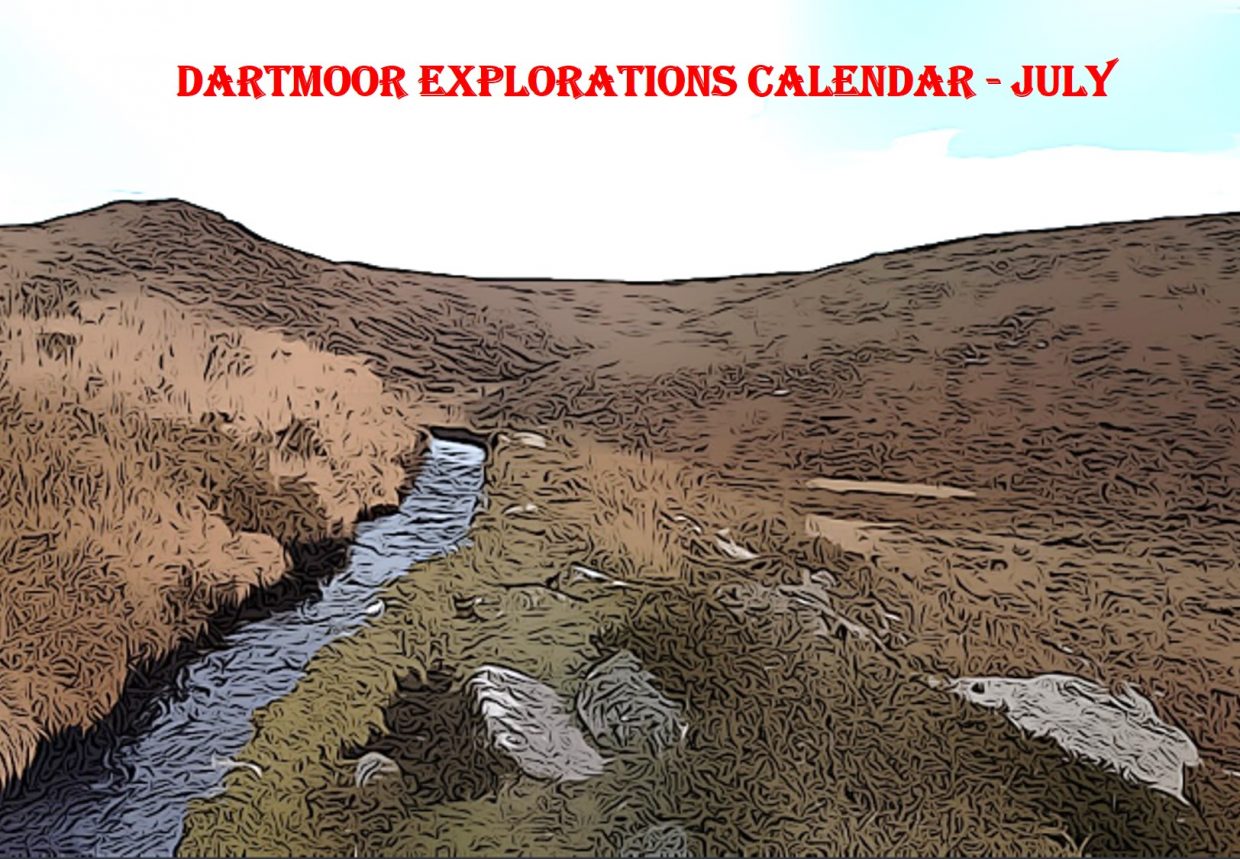
DARTMOOR EXPLORATIONS CALENDAR – JULY
In 1991, the Dartmoor National Park Authority (DNPA) published a spiral bound diary to commemorate their fortieth anniversary (1951-1991), called “The Dartmoor Diary”.
Inspired by this publication (and some of the entries in it) and to celebrate the DNPA 70th anniversary year in 2021, the “Dartmoor Explorations Calendar” records an event or story, complemented with photographs for each day of the year.
This page of the Dartmoor Explorations Calendar celebrates July on Dartmoor and its immediate borderland.
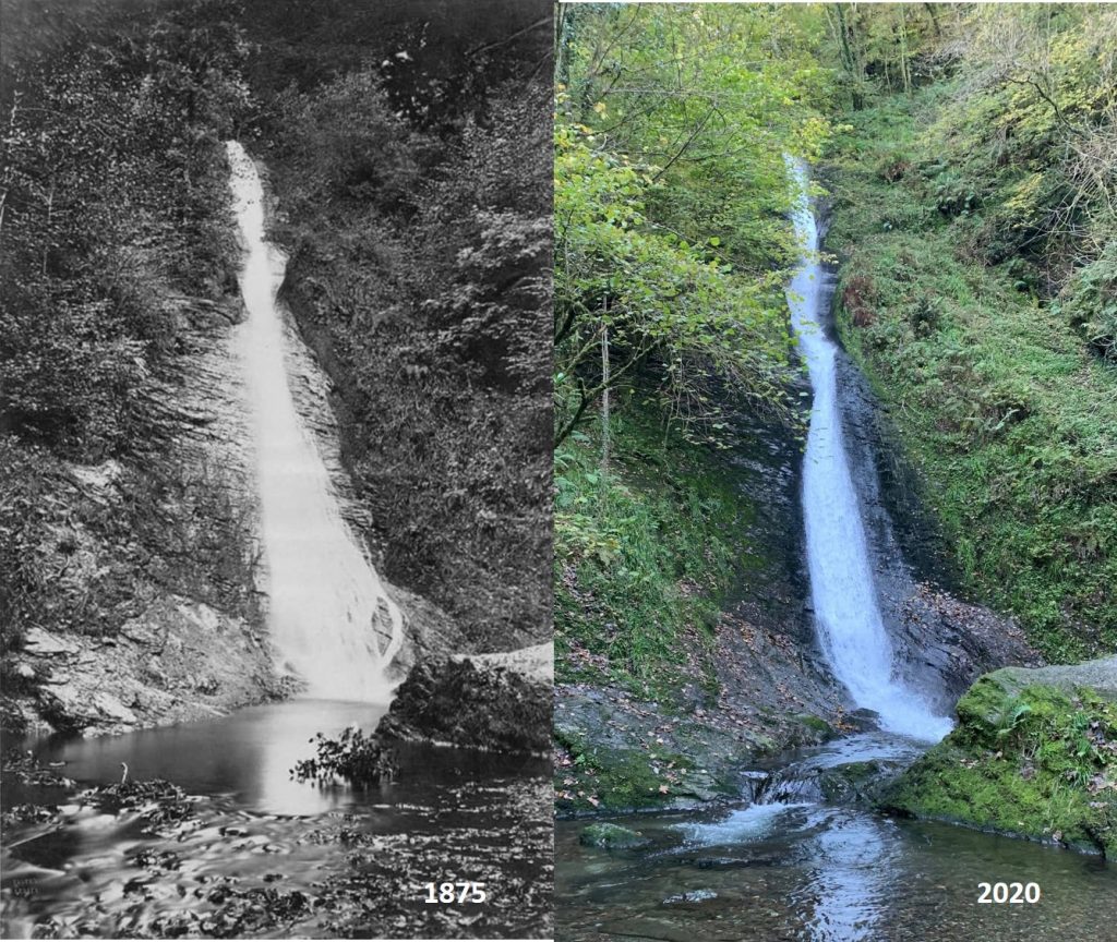
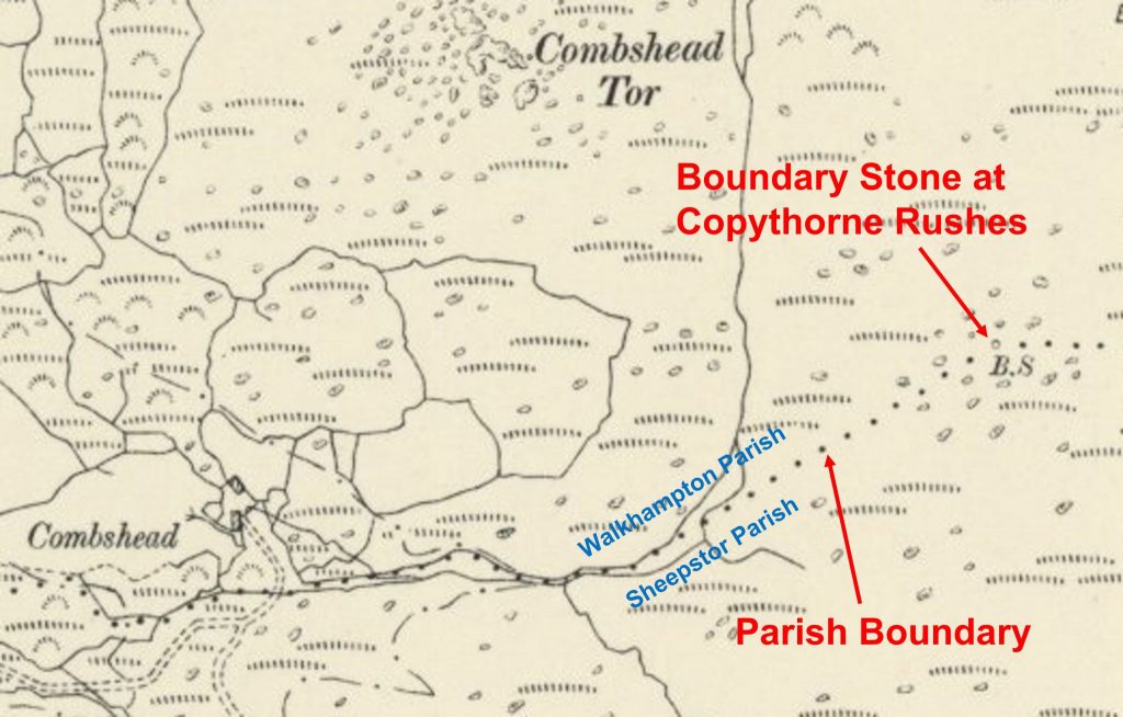
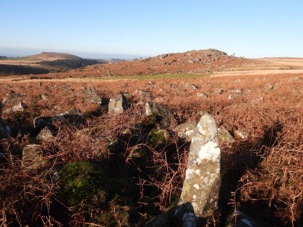
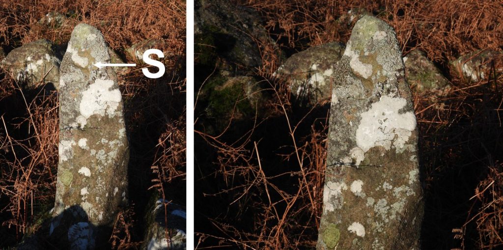
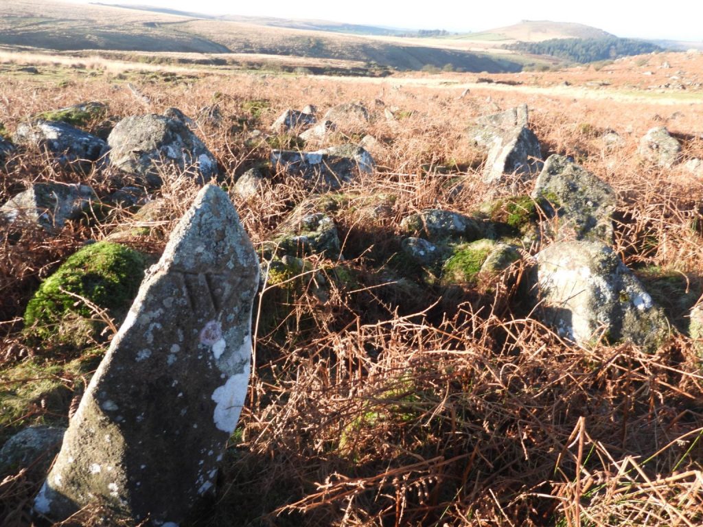
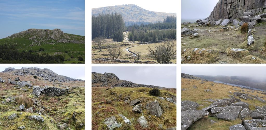
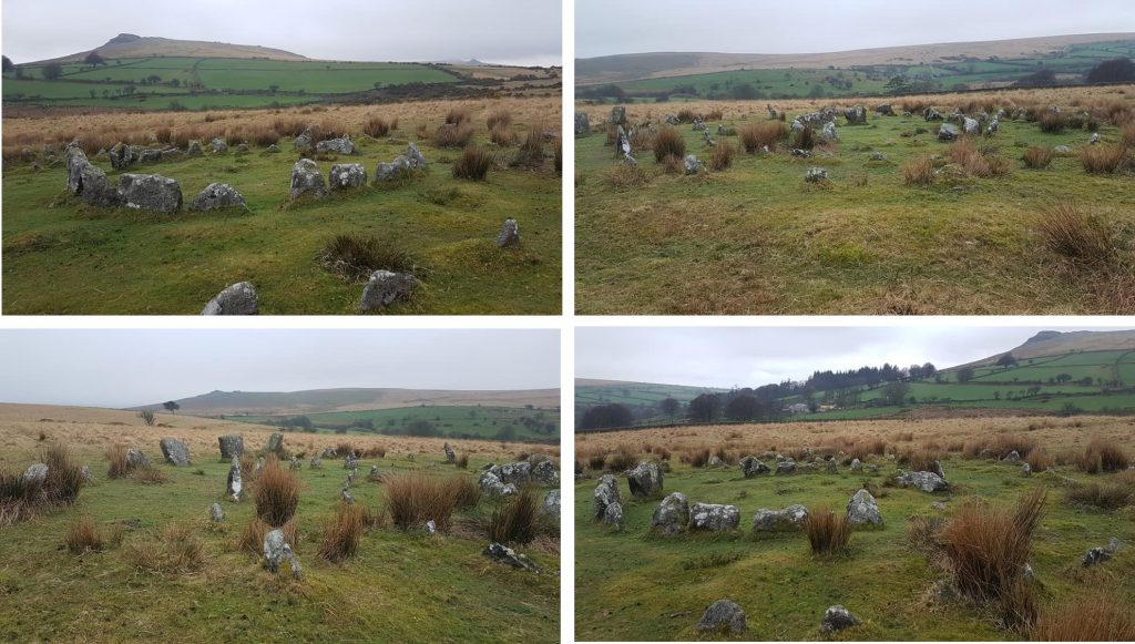
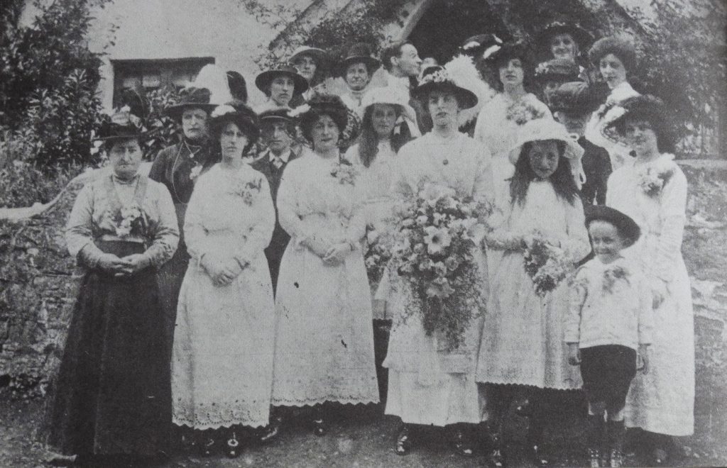
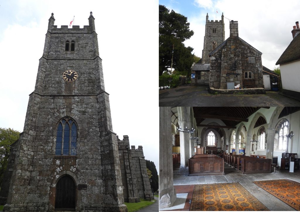
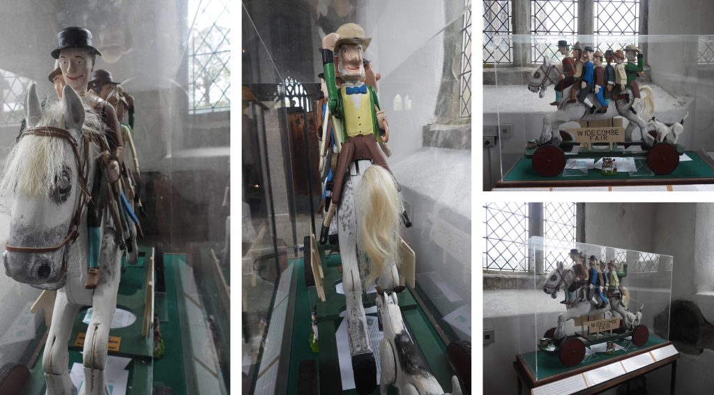
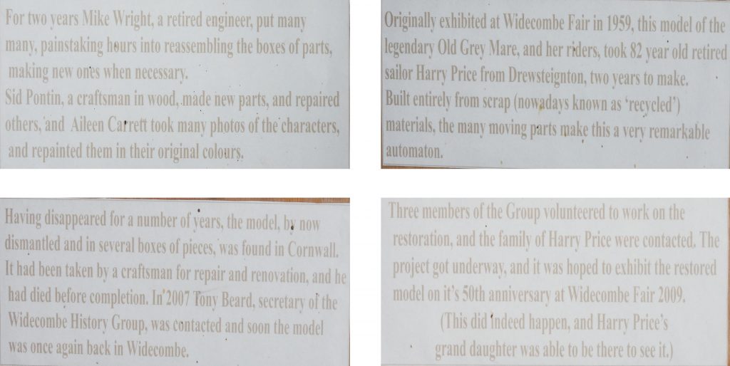
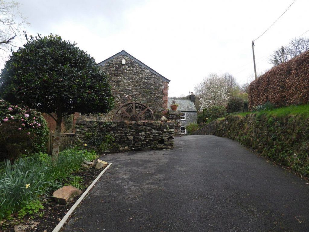
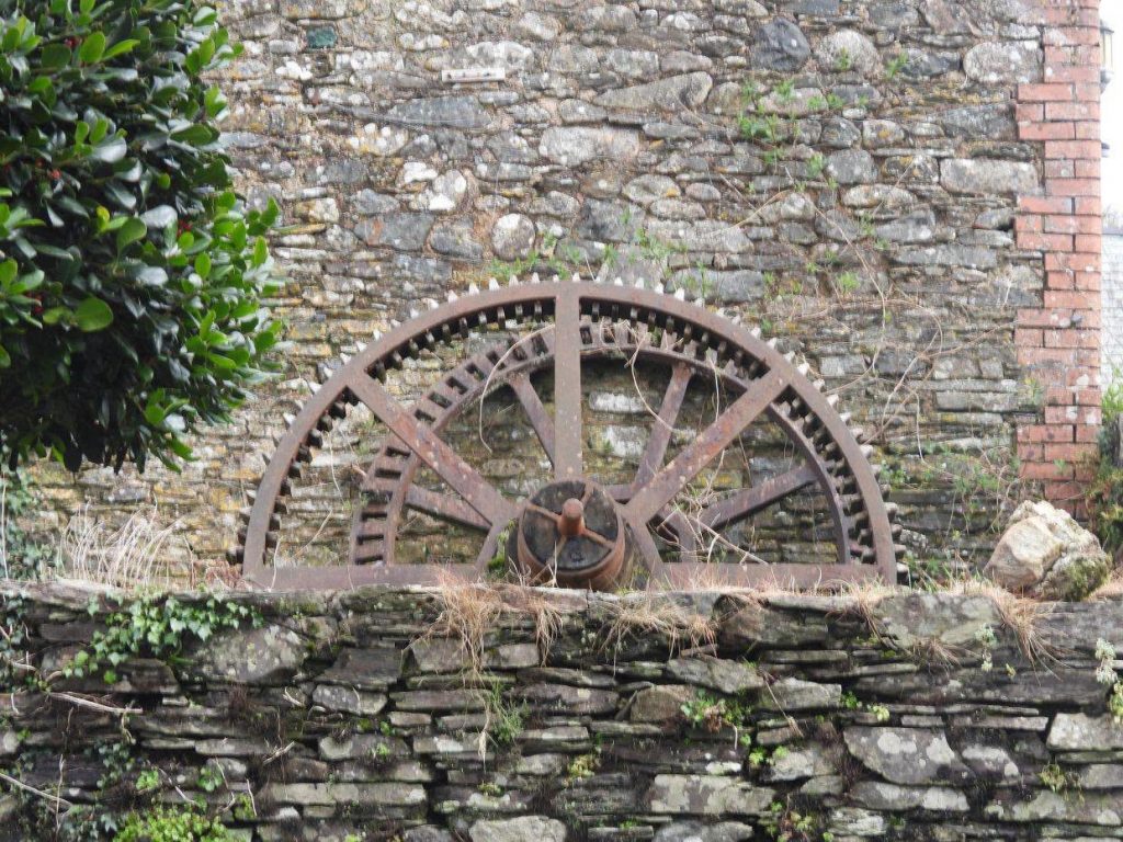
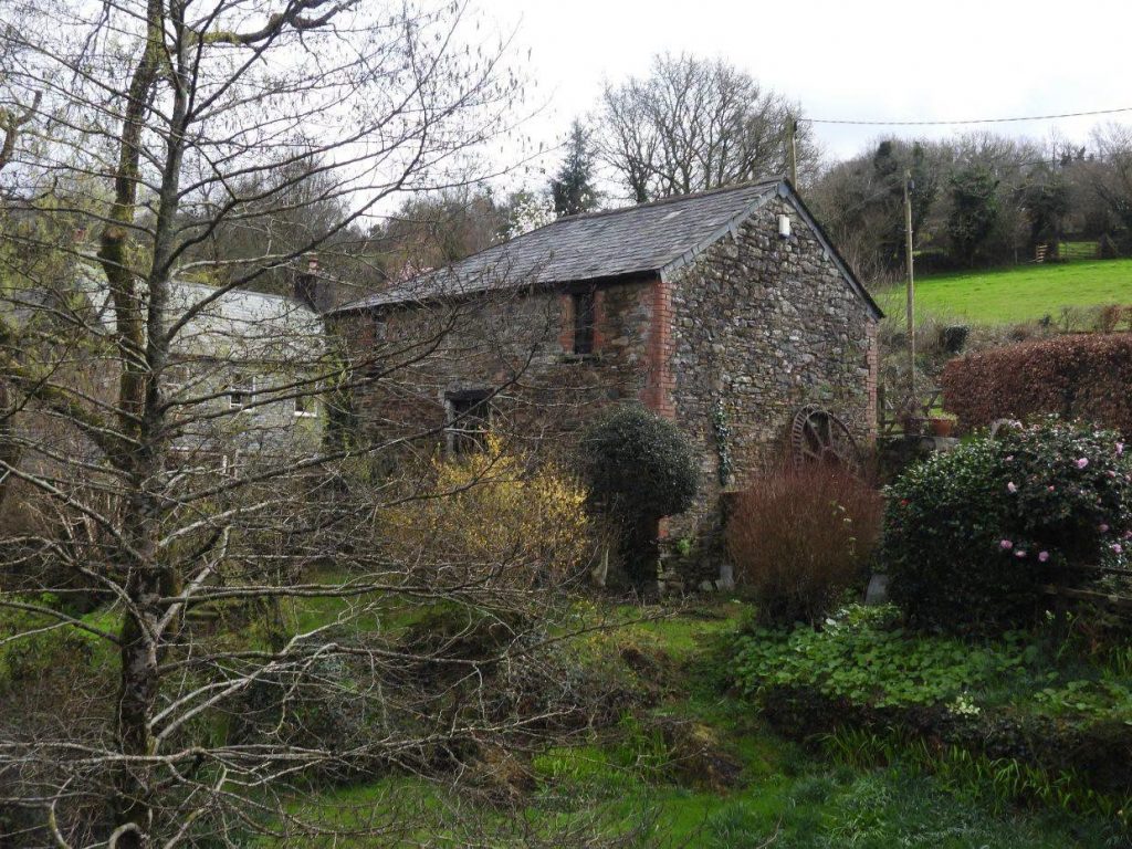
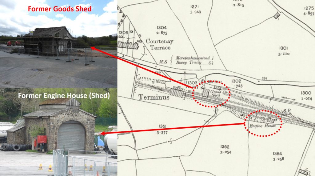
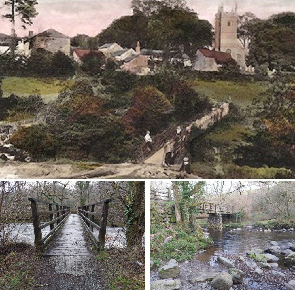
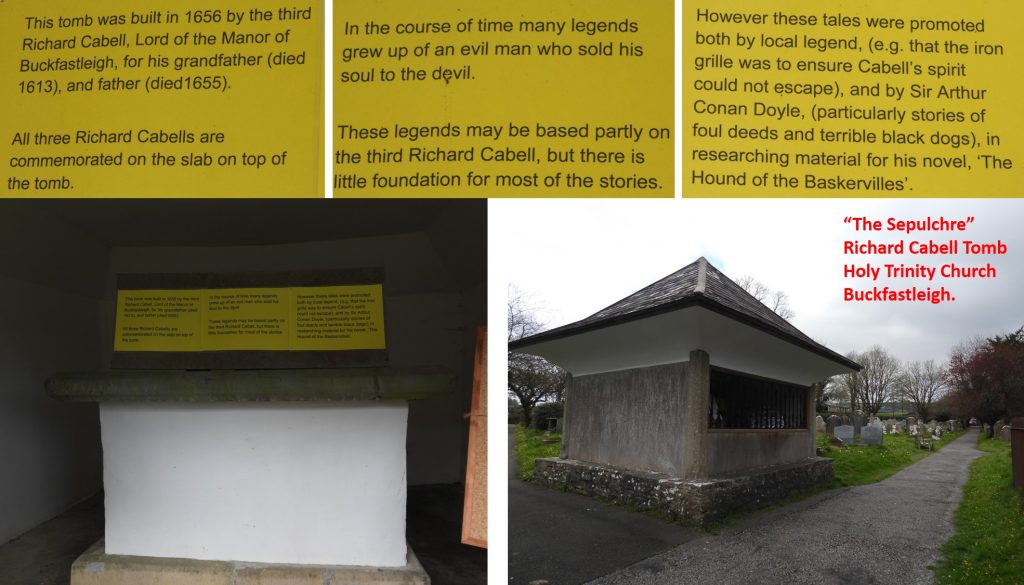
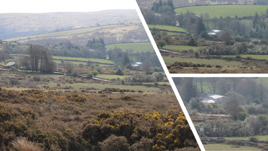
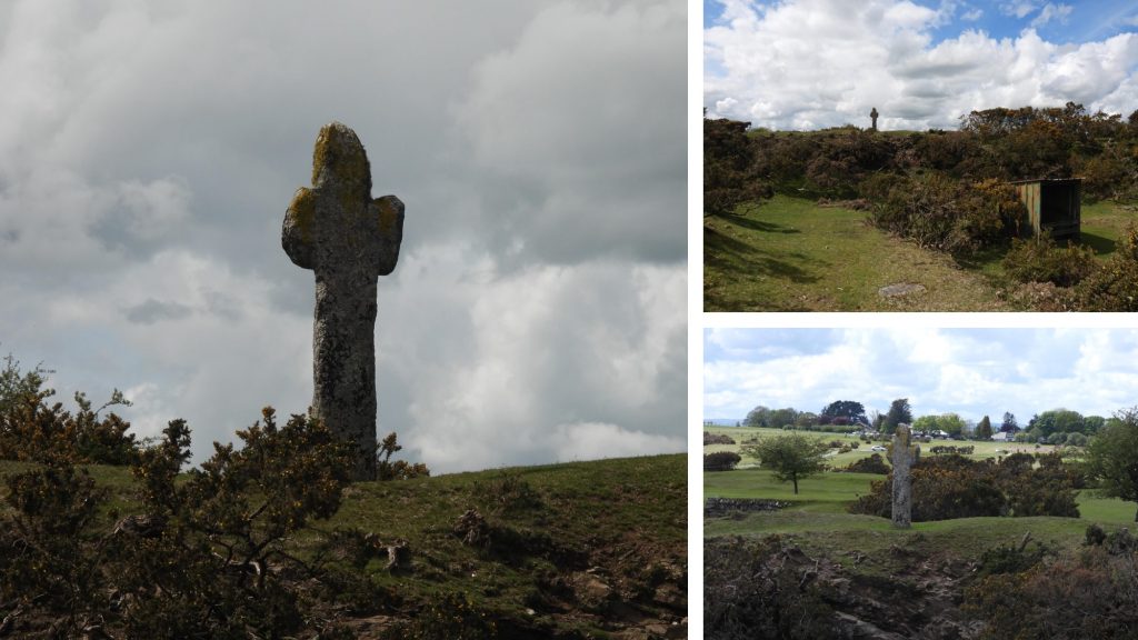
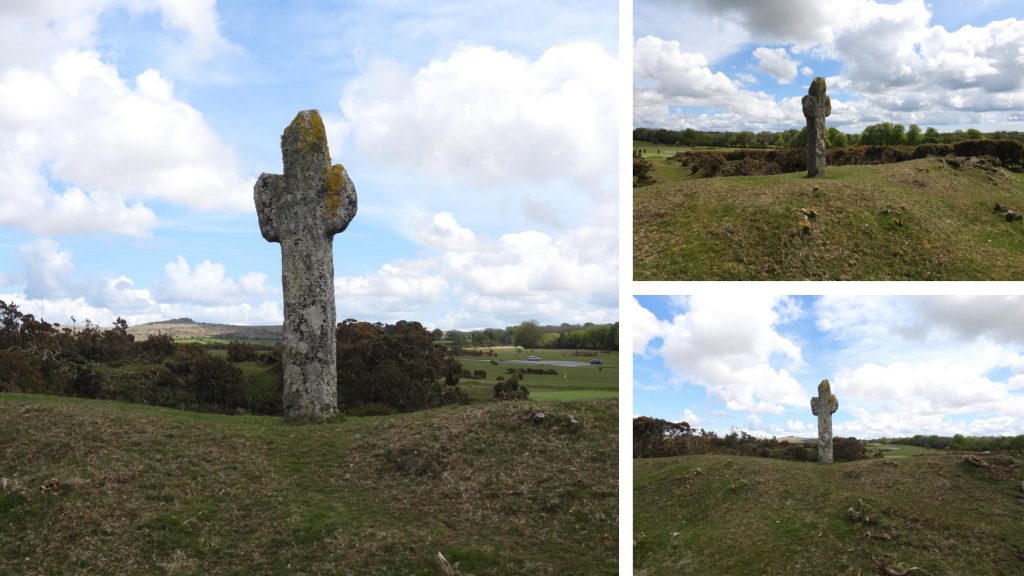
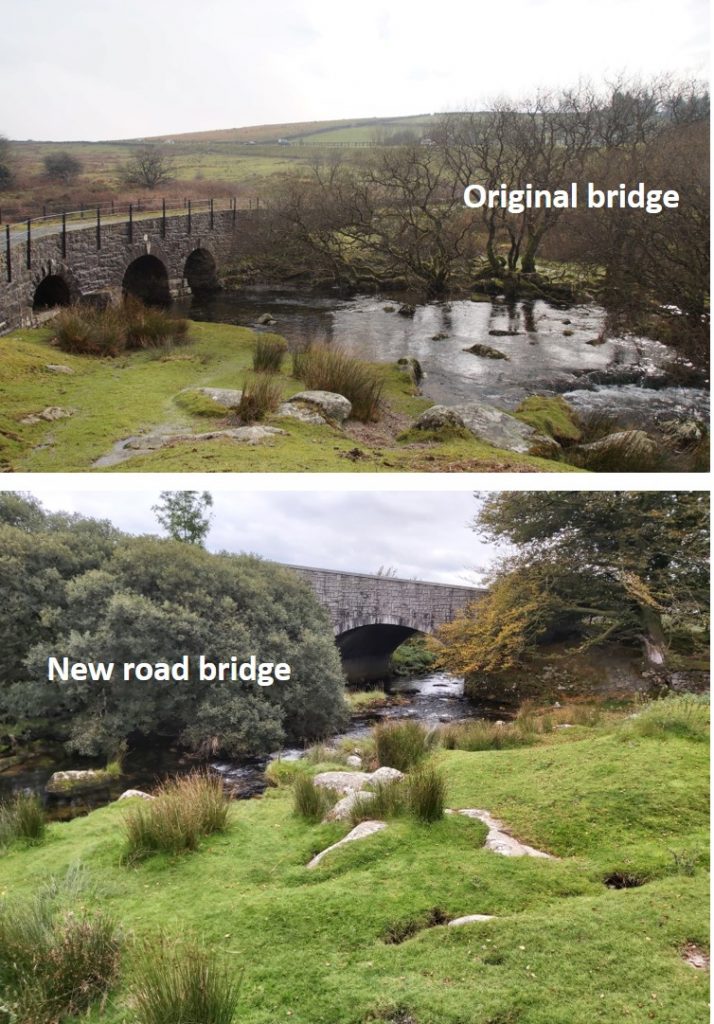
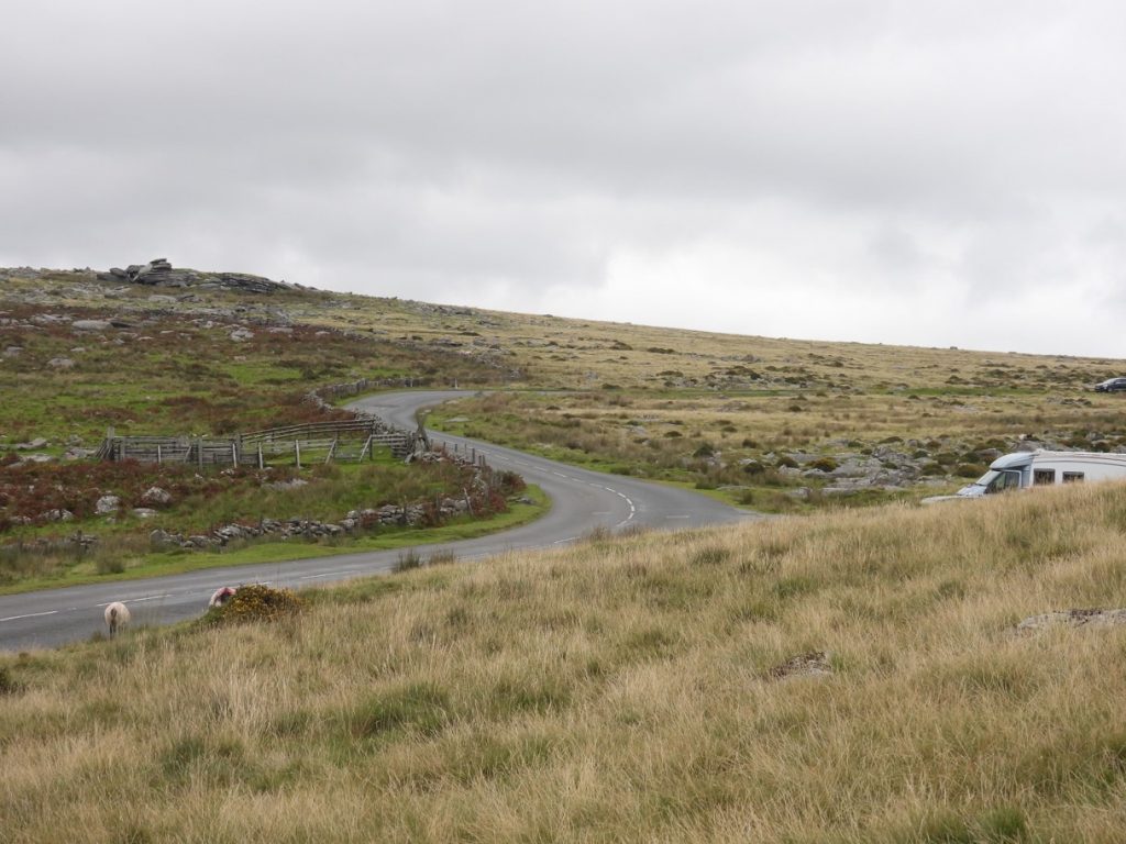
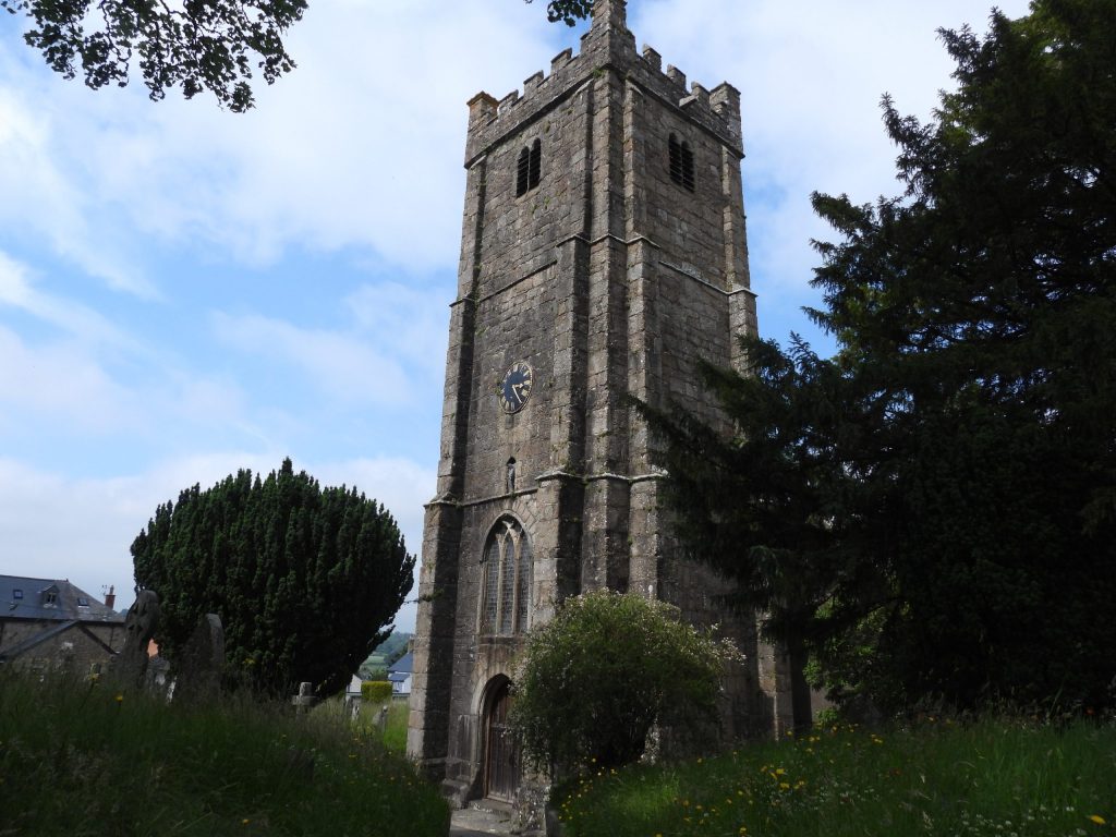
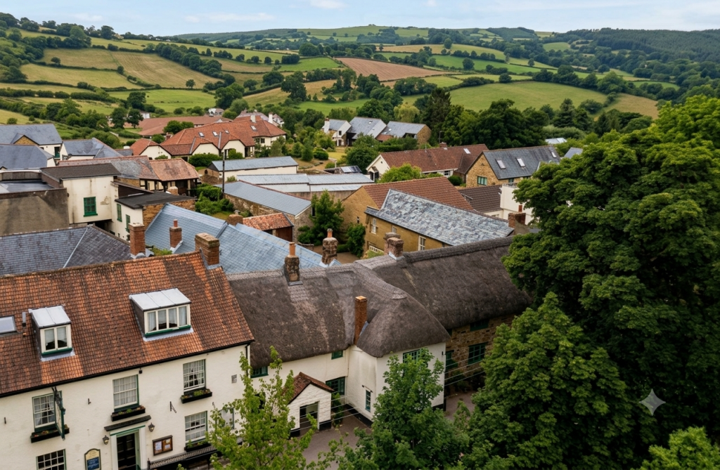
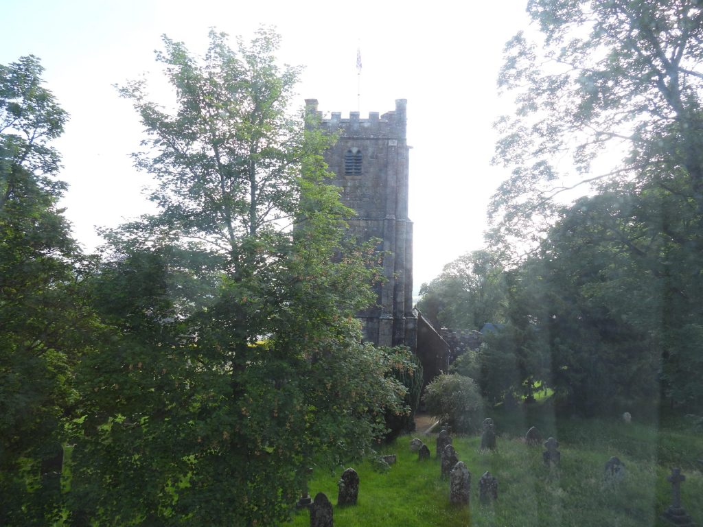
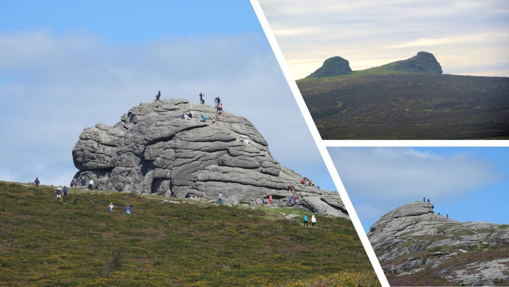
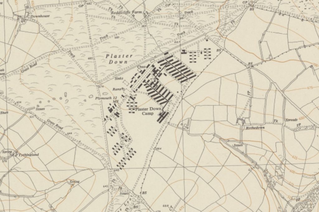
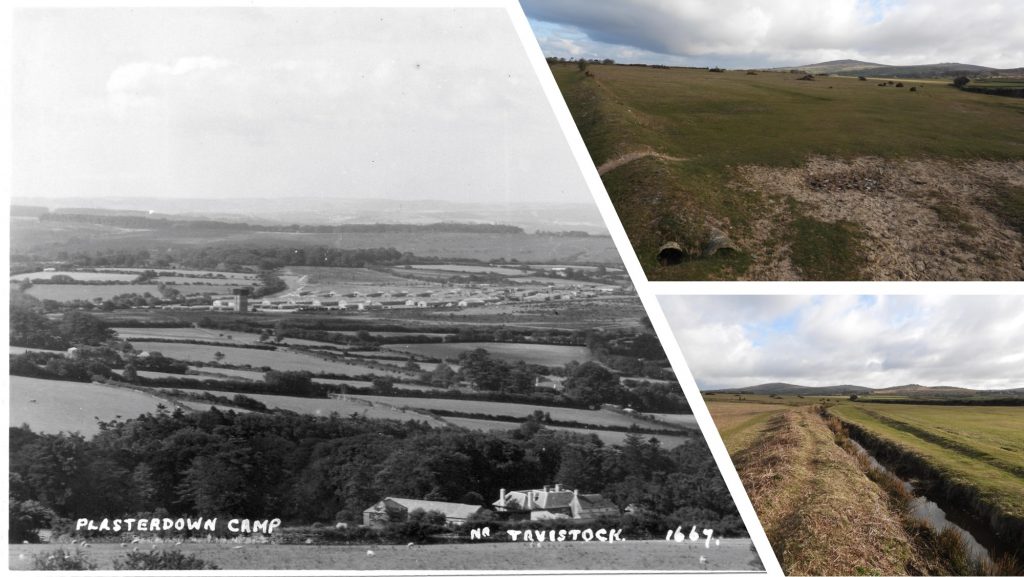
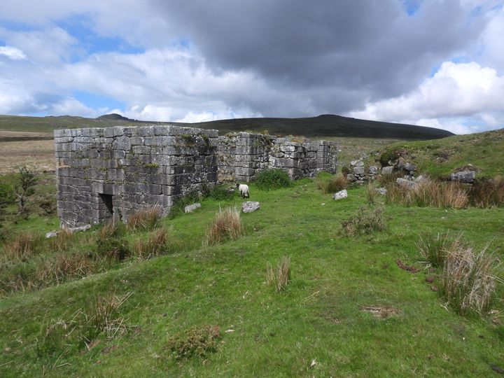
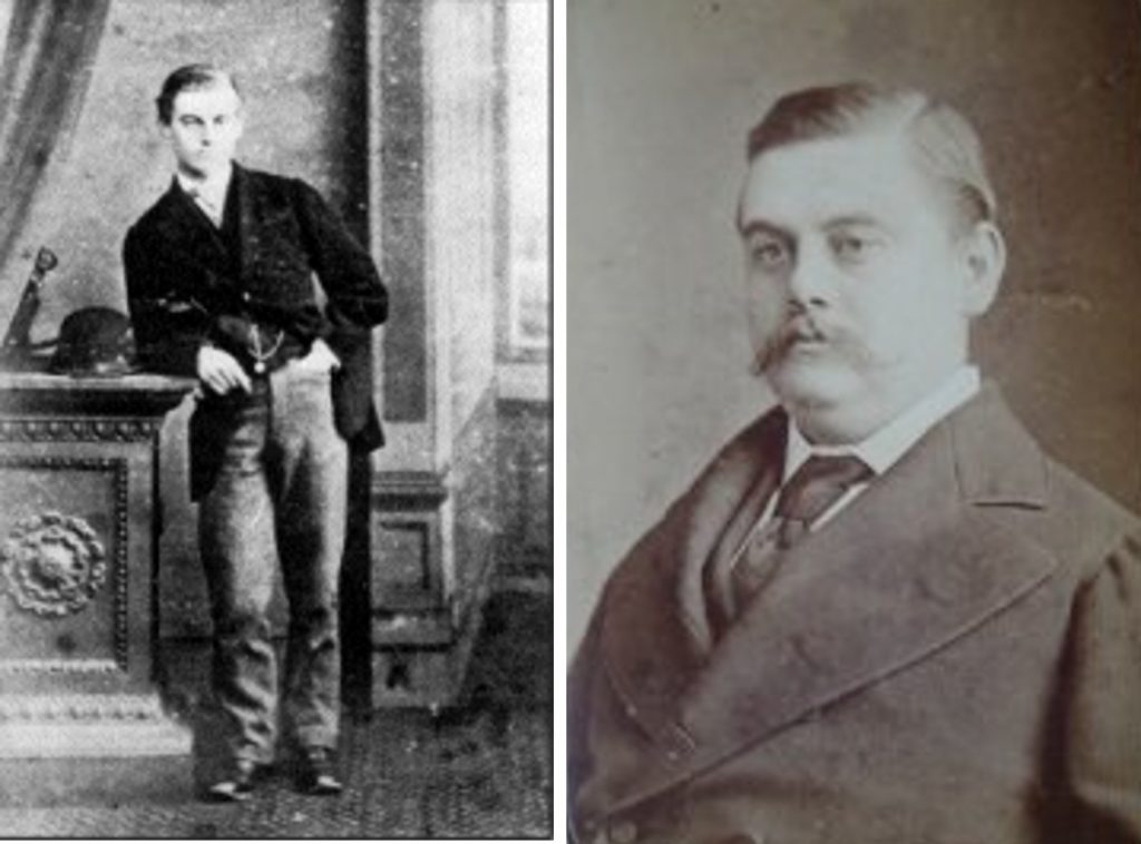
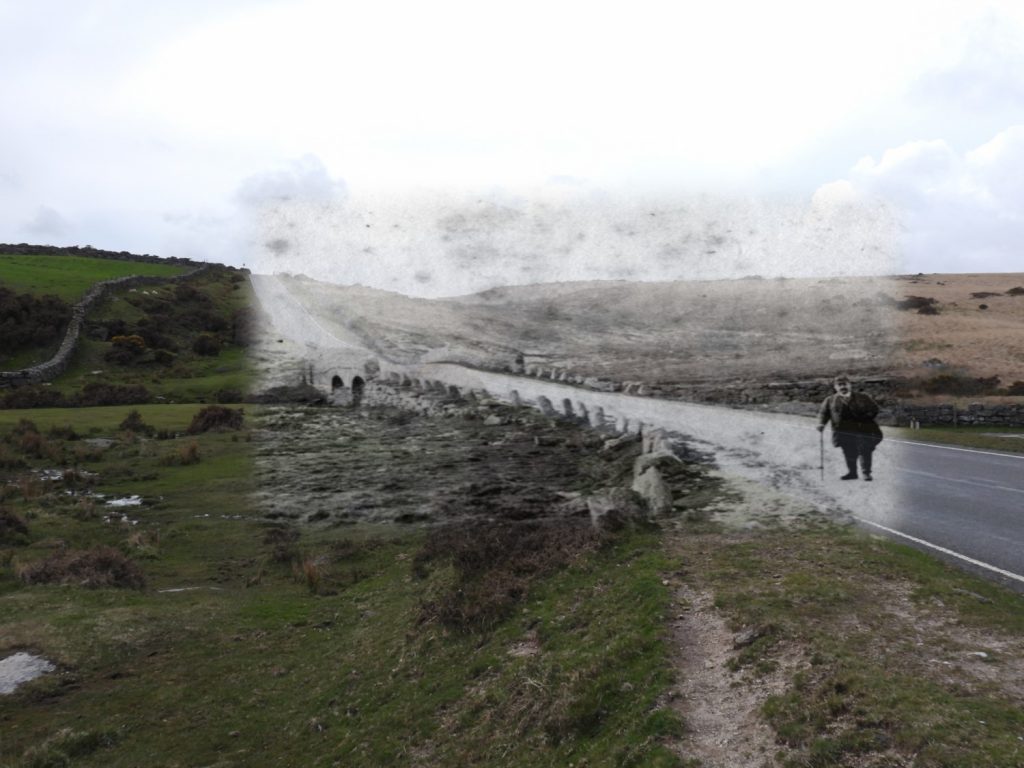
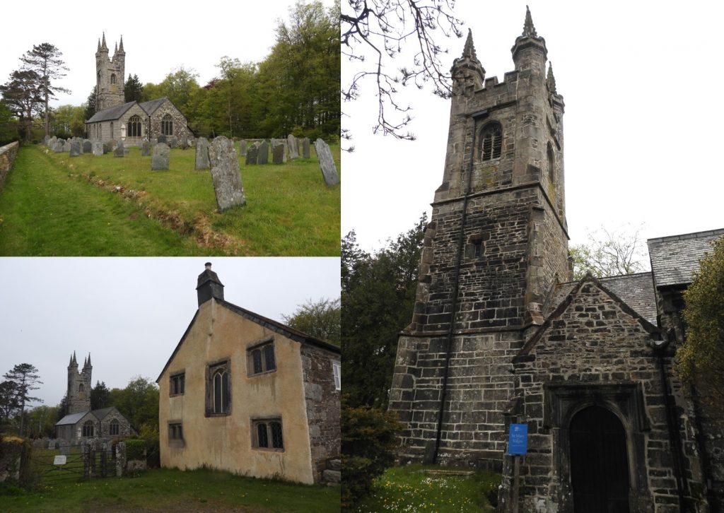
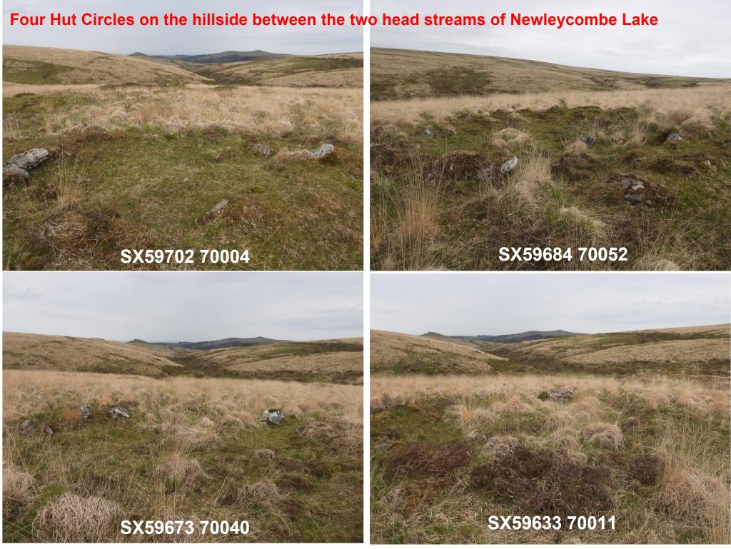
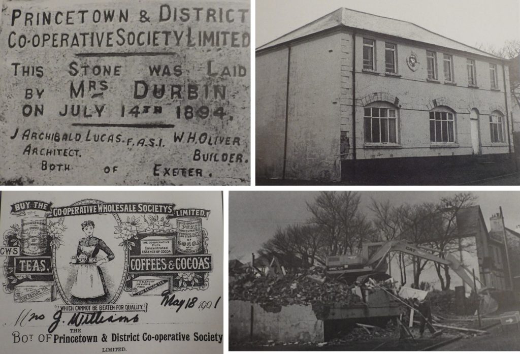
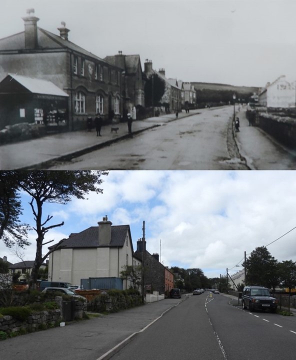
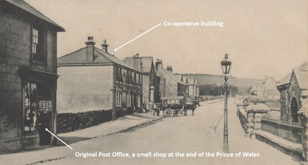
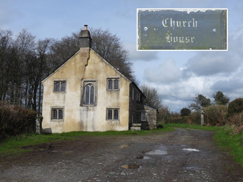
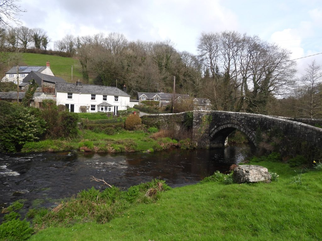
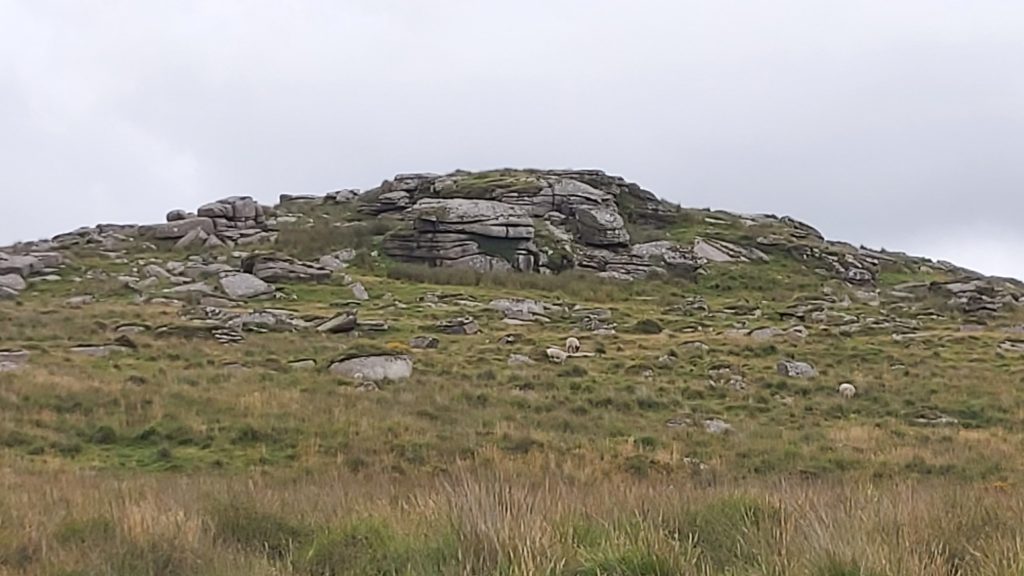
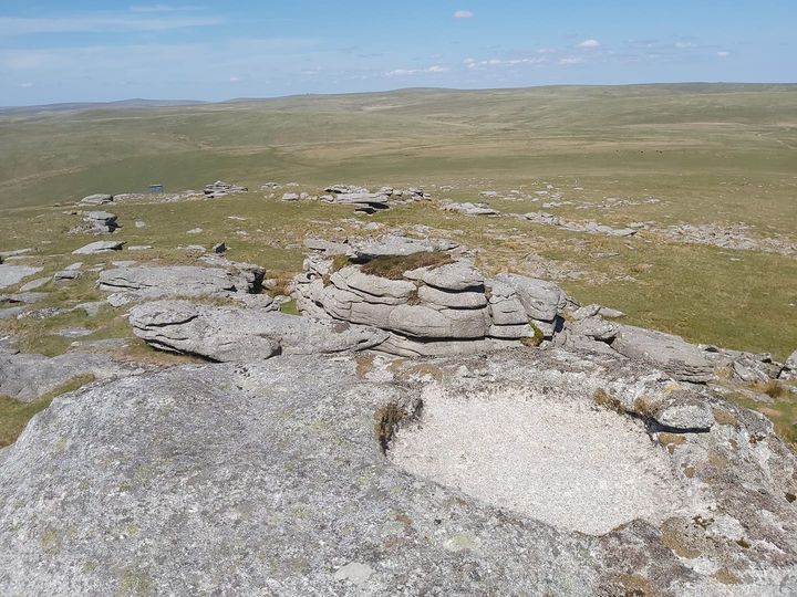
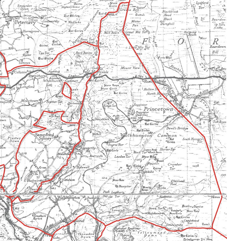
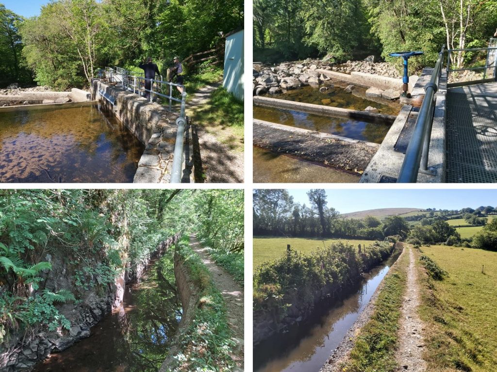
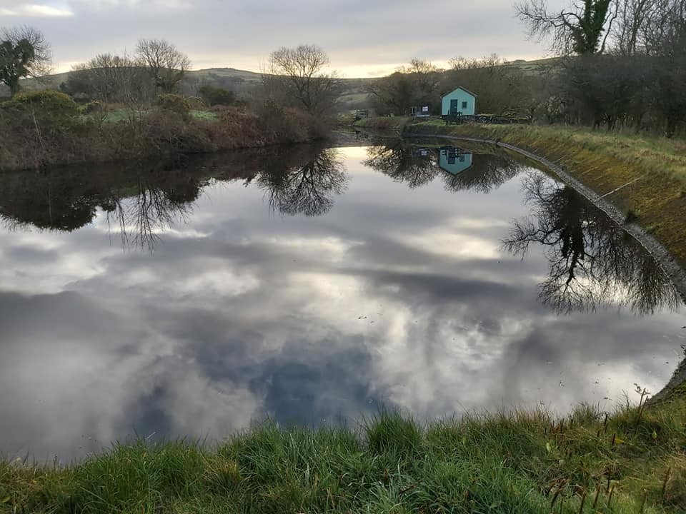
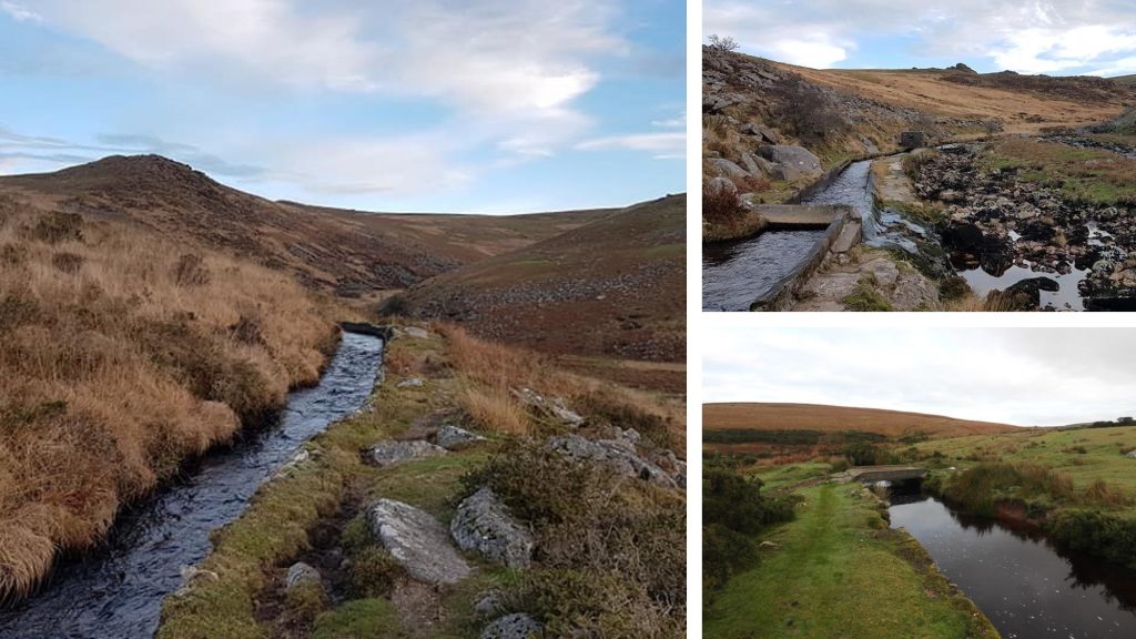
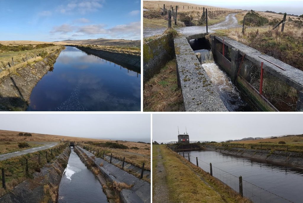
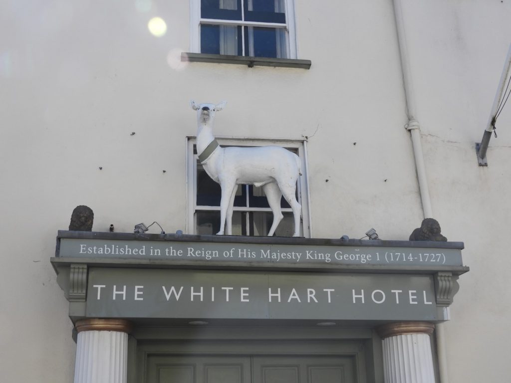
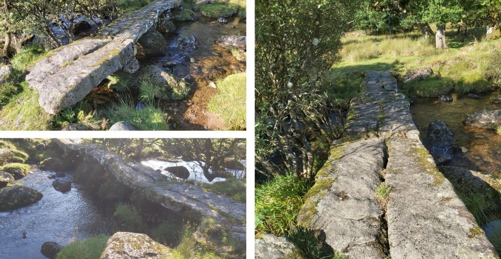
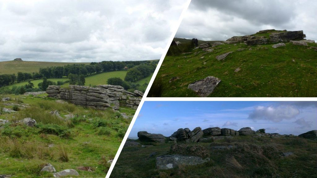
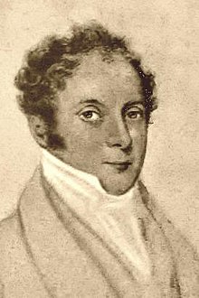
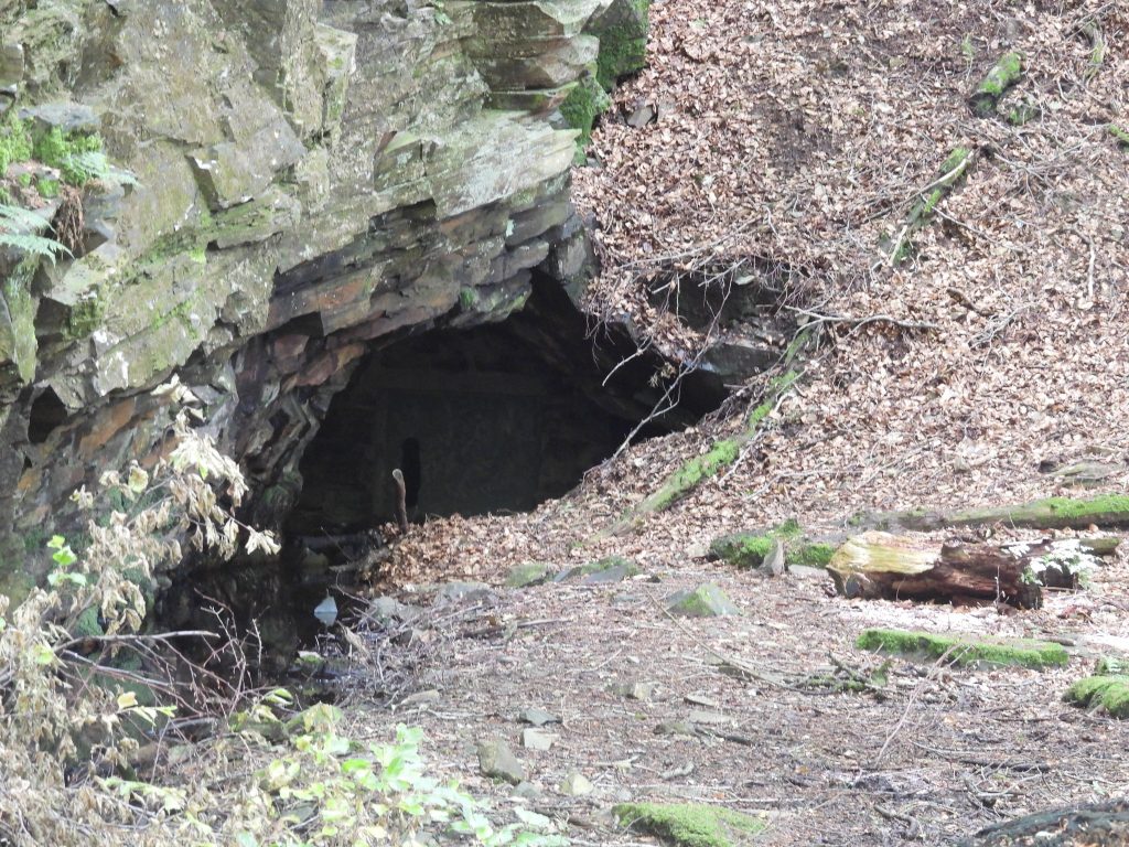
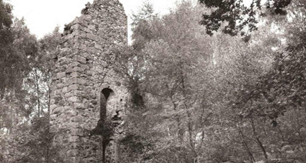
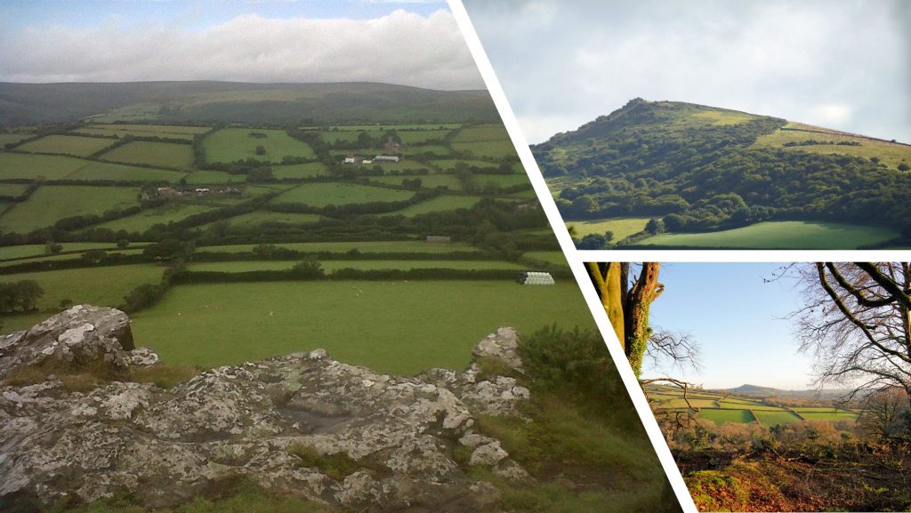
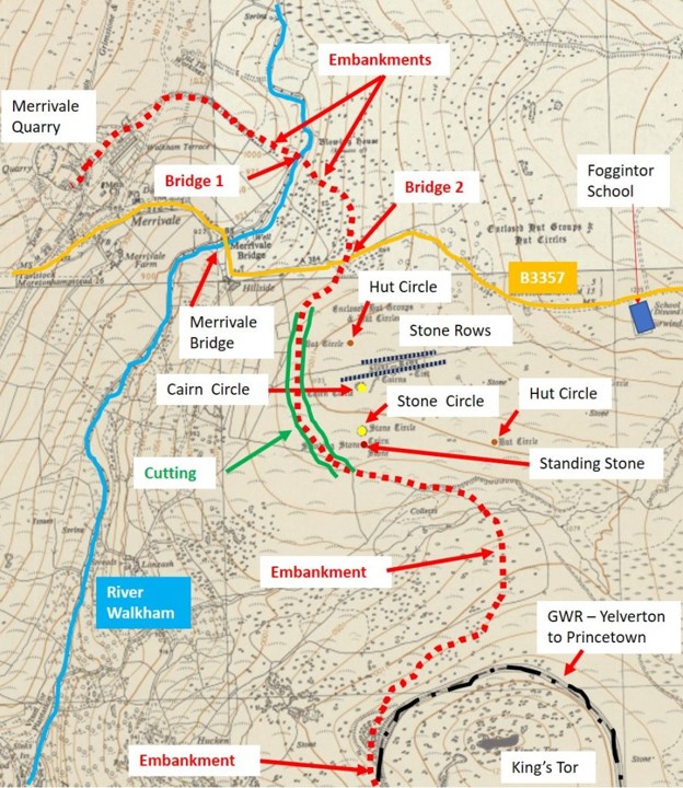
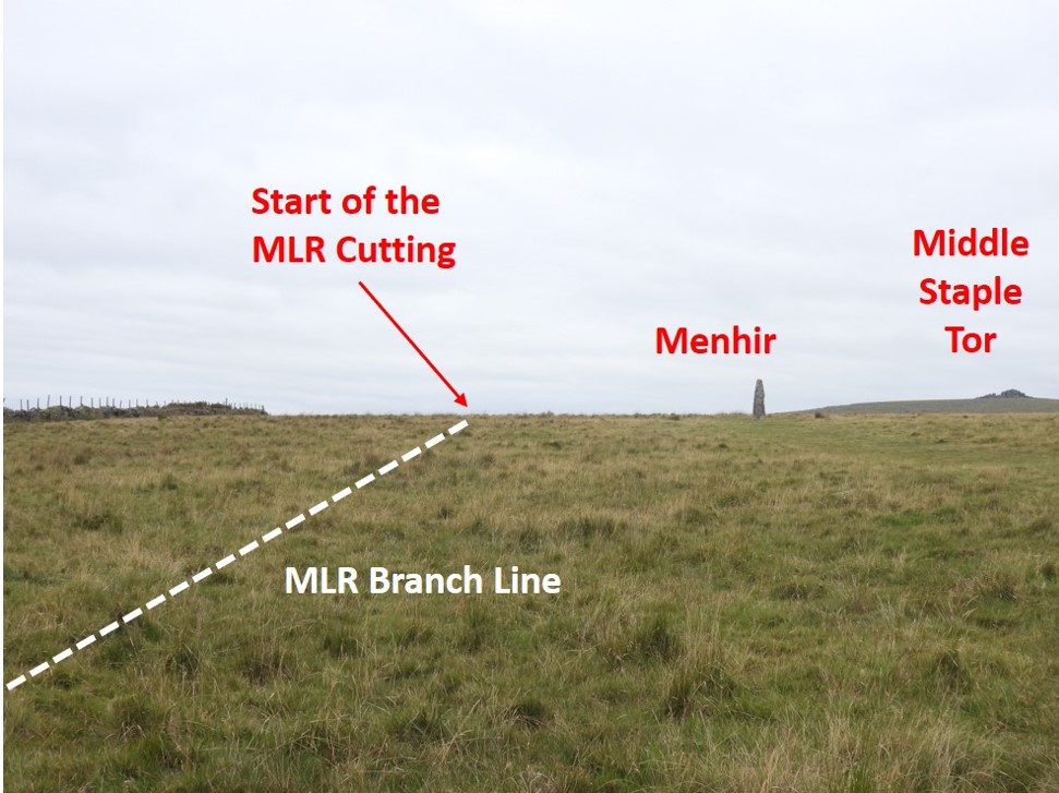
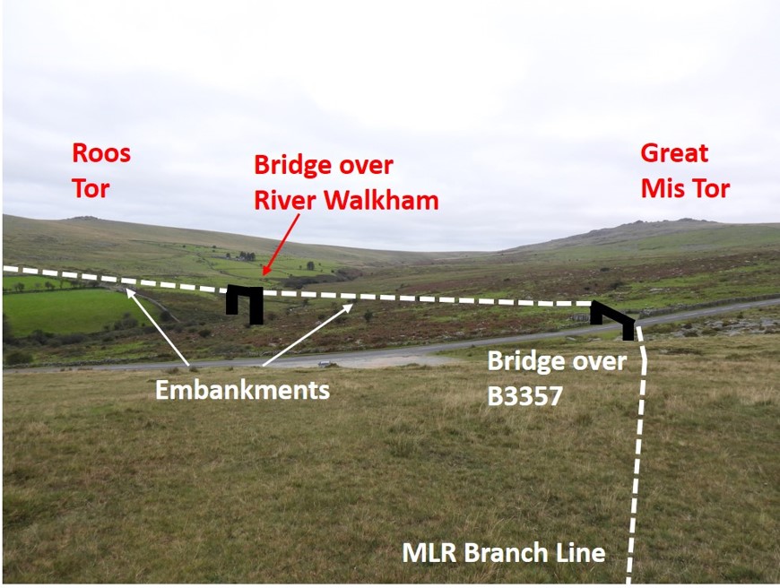
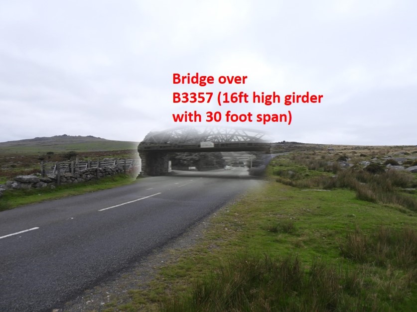
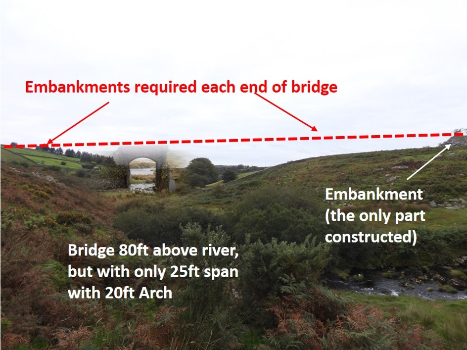
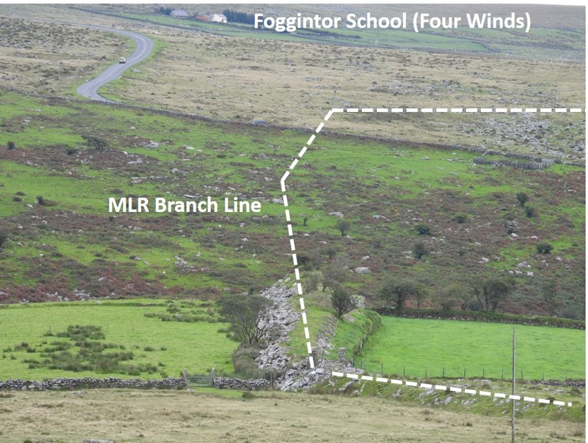
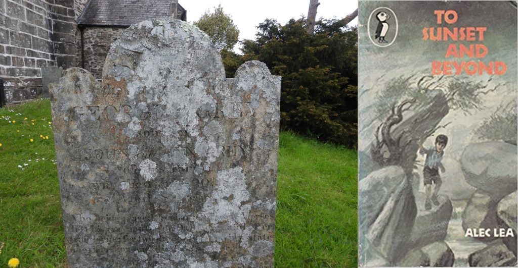
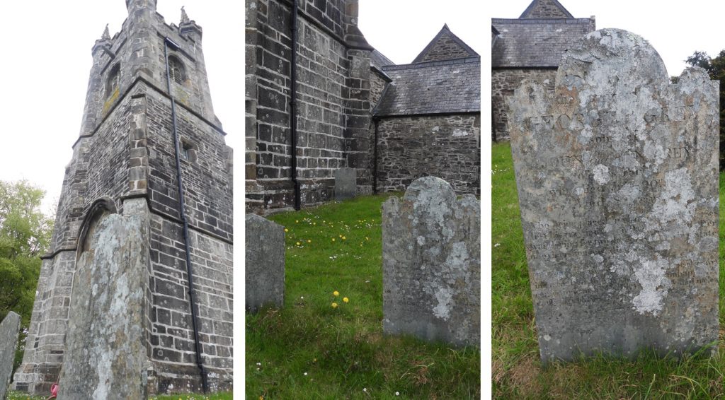
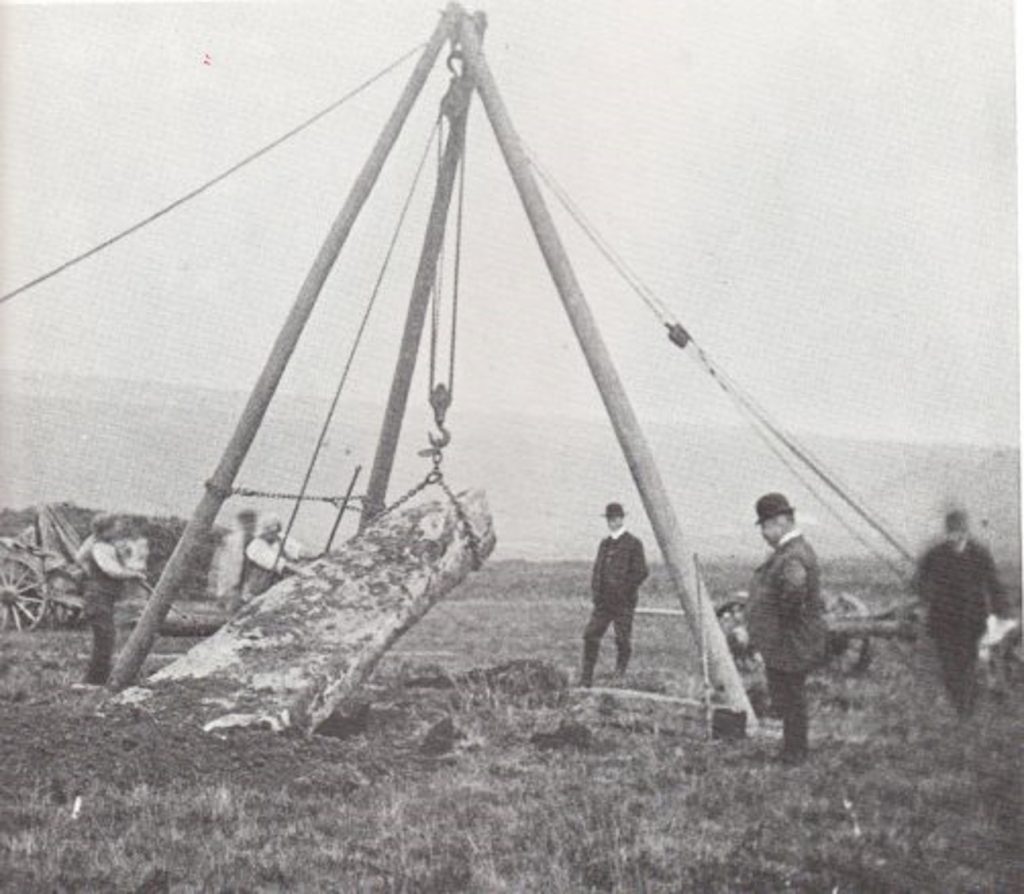
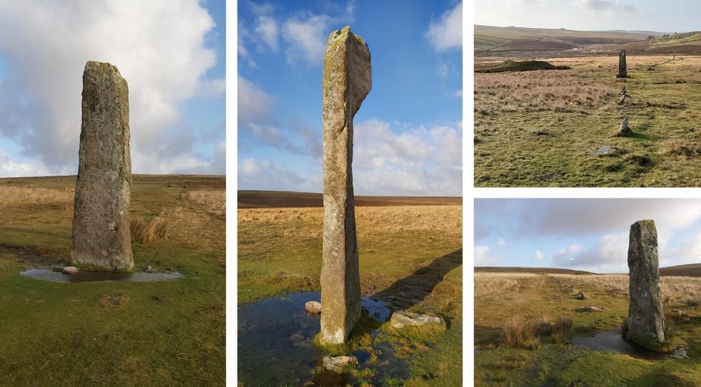
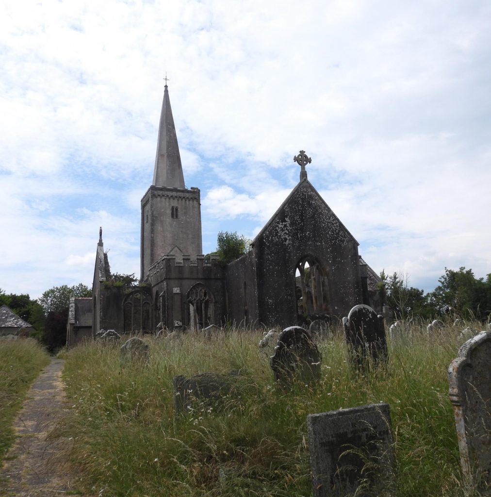
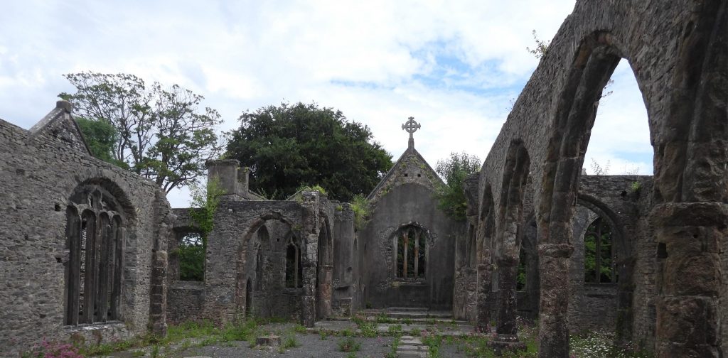
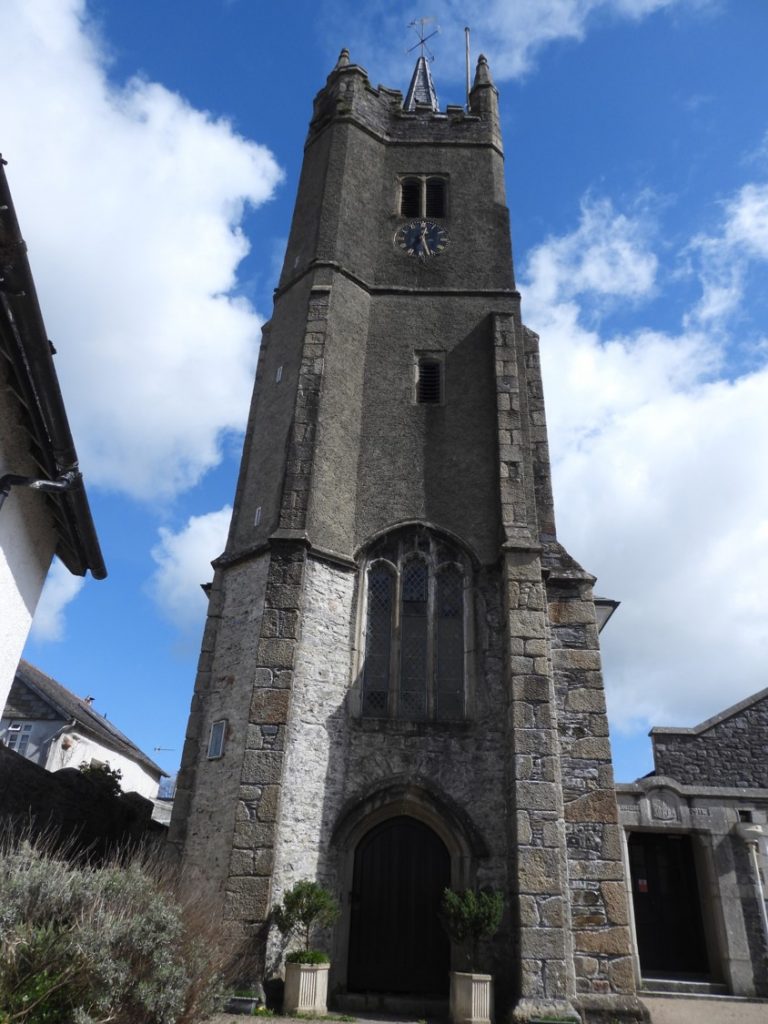
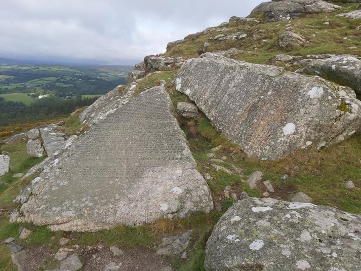
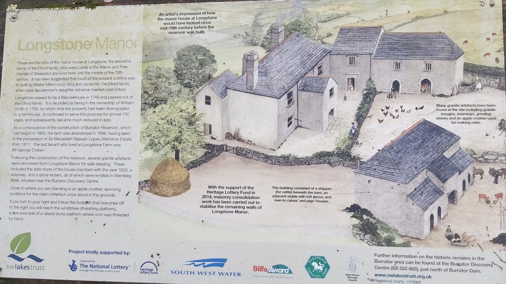
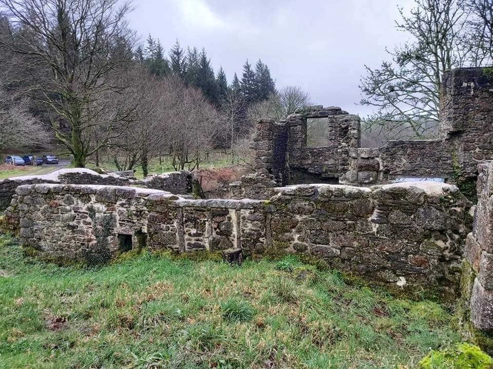
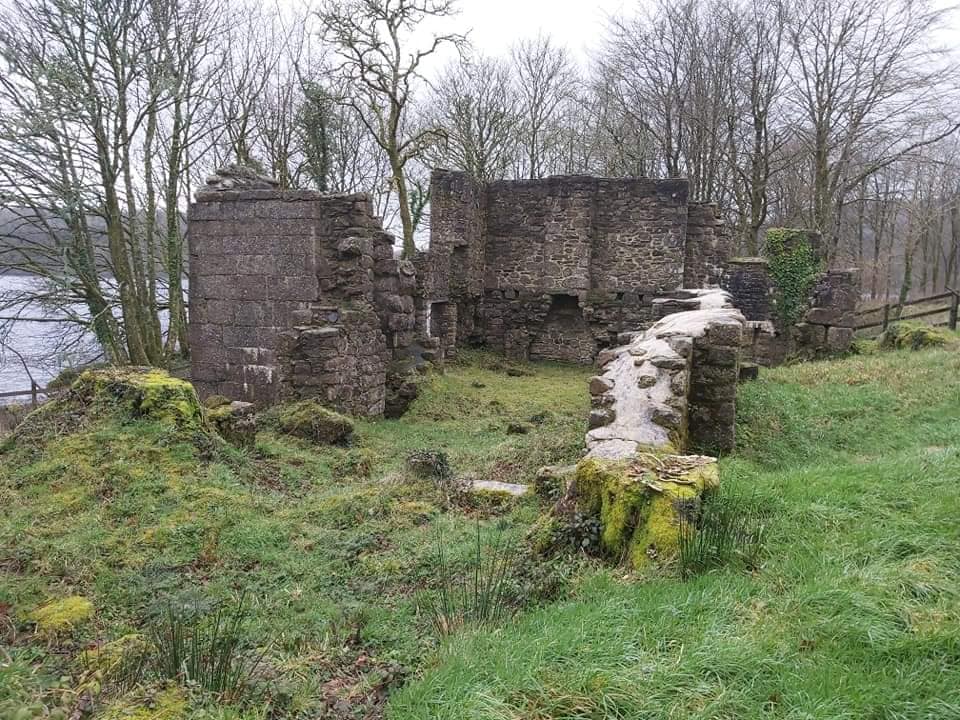
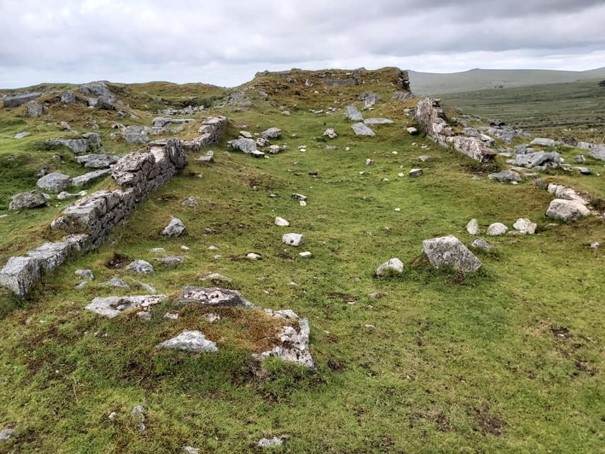
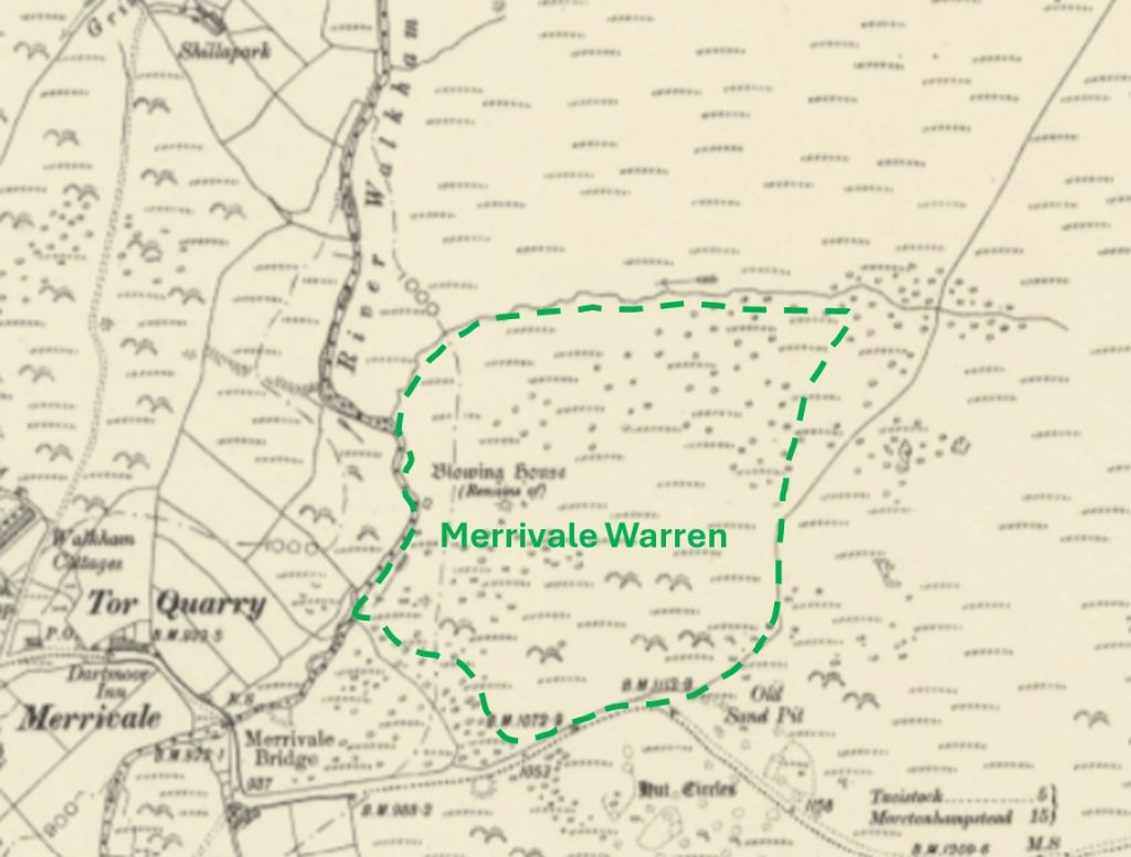
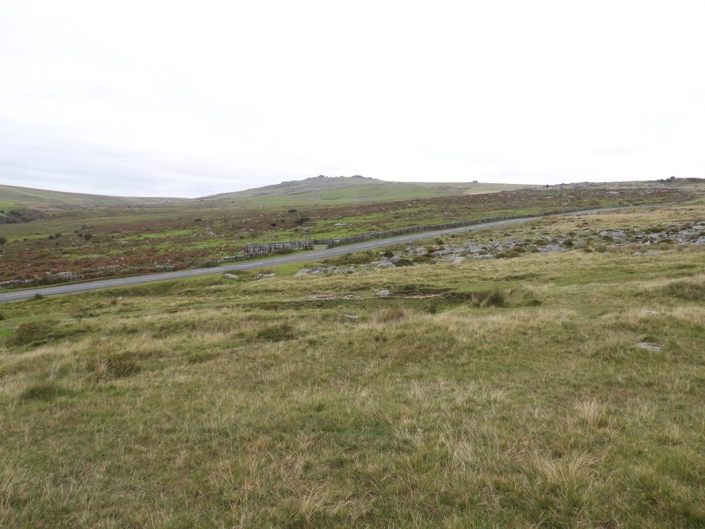
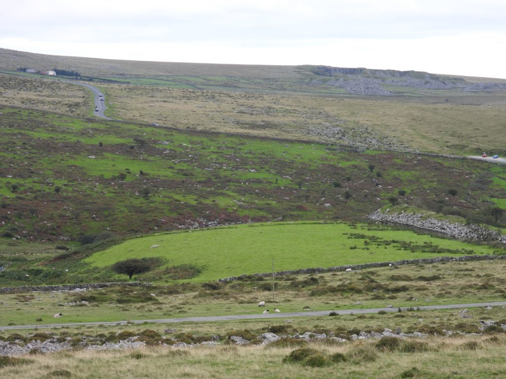
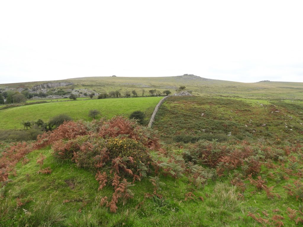
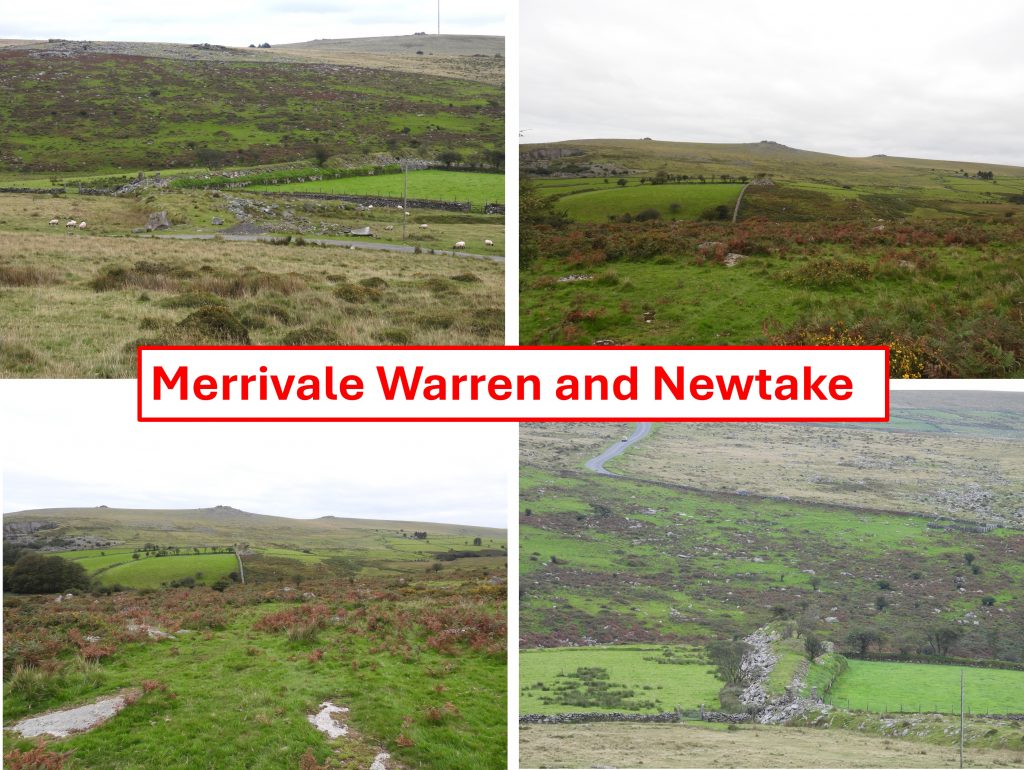
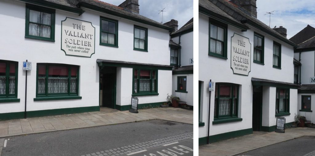
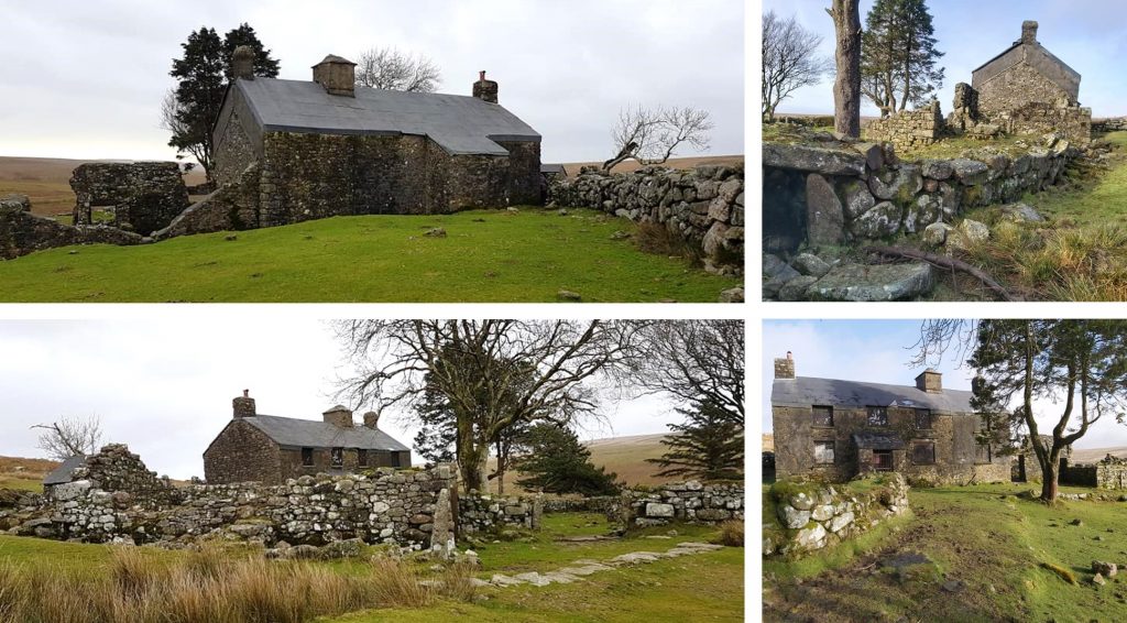
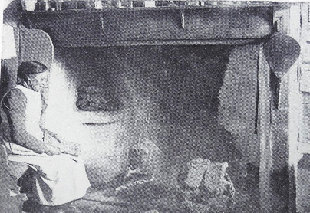
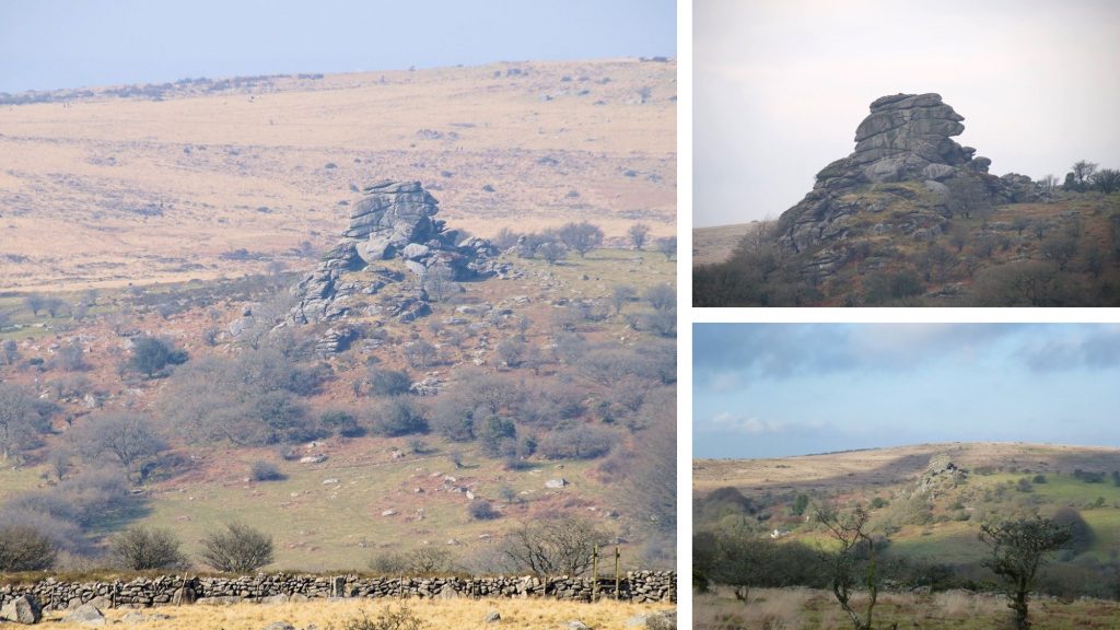
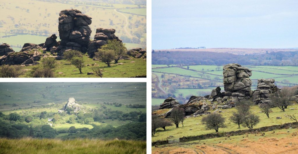
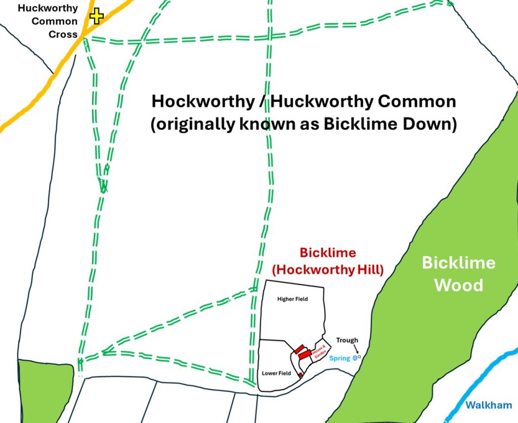
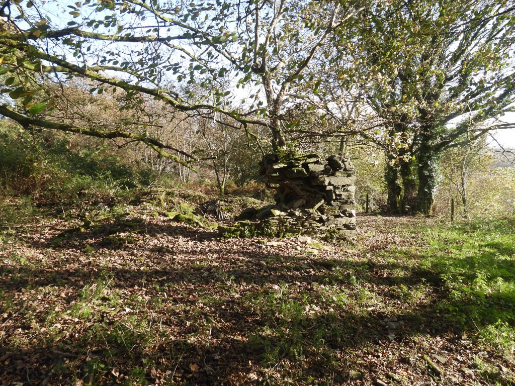
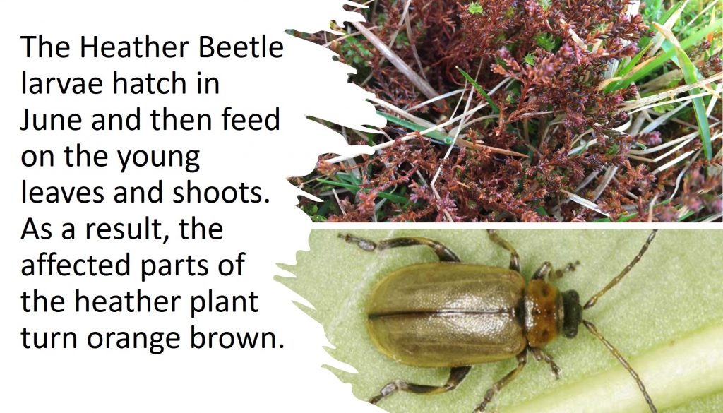
1st July 1890: A complaint appeared in the local press made by a tourist in respect of paying a toll, taken by the miller, to visit the Lydford cascade. Source: The Dartmoor Diary 1991 by DNP.1st July 1788: Richard Troop is paid half a crown (12.5 p) “for a Stone Sat up where a Thorne formerly Grew (called Copy Thorne)”. This annotated 19th Century Map showing the location of the boundary stone and the parish boundary. The stone is still shown on modern OS maps. It is the only boundary stone known to exist on the Sheepstor / Walkhampton Parish Boundary1st July 1788: Richard Troop is paid half a crown (12.5 p) “for a Stone Sat up where a Thorne formerly Grew (called Copy Thorne)”. View of the south side of the B.S with Combshead Tor (in the near distance) and Sheepstor (in the far distance). The B.S is recorded on the Dartmoor HER as being “1.2 metres high by 0.4 metres by 0.35 metres, tapering towards the top”. The B.S is located at SX59090 686271st July 1788: Richard Troop is paid half a crown (12.5 p) “for a Stone Sat up where a Thorne formerly Grew (called Copy Thorne)”. Near the top of the B.S an “S” (for Sheepstor) is inscribed.1st July 1788: Richard Troop is paid half a crown (12.5 p) “for a Stone Sat up where a Thorne formerly Grew (called Copy Thorne)”. View of the north side of the B.S with the line of Narrator Brook easily discernible2nd July 2004: Sheepstor and surrounding moorland totalling 125 acres was sold plus a further 350 acres of shooting rights. This included the rights to maintain a boathouse. The auction was conducted by Symonds and Sampson of Yeovil and despite the fact the reserve wasn’t achieved, the sale value was £90,000. Source: Dartmoor Magazine, Autumn 2004, number 76. The pictures: Top left is view from Ringmoor Down, Middle Top is view from Black Tor stone row, Top right is vermin trap near top of tor, Bottom left is the warreners house, Middle bottom is a pillow mound on south side of tor and Bottom right is looking over Burrator reservoir from Narrow Tor. 2nd July 2004: Sheepstor and surrounding moorland totalling 125 acres was sold plus a further 350 acres of shooting rights. The land was put up for sale by Captain Sandy Maxwell-Hyslop, whose distant relatives, the Bayley family had owned lands in the area from 1830s. The sale included Yellowmead (quadruple) stone circle shown in the pictures.3rd July 1915: Harry Price, believed to be the only person in the village of Drewsteignton to own a camera, took photographs of his own wedding. The picture above is of the bride and guests outside the bride’s mother’s cottage. The soon to be Mrs Price is Ethel Ashplant3rd July 1915: Harry Price, believed to be the only person in the village of Drewsteignton to own a camera, took photographs of his own wedding. Source: The Dartmoor Diary 1991 by DNP. The pictures are of the Holy Trinity Church in the village, which is assumed is where Harry was married. 3rd July 1915: Harry Price from Drewsteignton took photographs of his own wedding. Harry was an “Ordinary Seaman” who became a well travelled figure, producing accounts and drawings of his travels, and publishing his account of the Royal cruise he was part of aboard the temporarily commissioned HMS Ophir in 1901. In later life, he settled in Drewsteignton and became a talented naturalist, eventually developing a substantial collection of birds’ eggs and butterflies. He became a freelance collector for Watkins and Doncaster, of The Strand. Together with Richard and Cherry Kearton they became pioneers in the development of bird photography – is this the link to the wedding photograph story?3rd July 1915: Harry Price from Drewsteignton took photographs of his own wedding. In much later life, Harry took up wood carving (when over 70 years old). One of his mechanical models was of Uncle Tom Cobley and the Grey Mare (Widecombe Fair) and is kept on display at Widecombe St Pancras Church.3rd July 1915: Harry Price from Drewsteignton took photographs of his own wedding. The story of his mechanical model of Uncle Tom Cobley and the Grey Mare (Widecombe Fair) is described in a series of panels.3rd July 1834 : John Underhill paid £6 18s for an oak tree, to be used as a shaft for a new waterwheel to be installed at Huckworthy Mill near Walkhampton (ref: Dartmoor 2001, Mike Brown). Huckworthy Corn Mill and house are depicted from early 19th century maps onwards. Intriguingly, the mill may date back a further 300 years. The Plymouth and West Devon Record Office hold a source dating the leat which fed the mill from late 16th century. The source is a licence, which is dated 30th November 1578 to Jerome Mayhowe of Boringdon, esquire and Nicholas Slanning of Bickleigh, esquire: “To construct and maintain a weir at Byklym Wood alias Buckym Wood (Bicklime Wood) in the water called the Walkham, for his mill at Hokeford Bridge (Huckworthy)”.3rd July 1834 : John Underhill paid £6 18s for an oak tree, to be used as a shaft for a new waterwheel to be installed at Huckworthy Mill near Walkhampton. Helen Harris recorded an entry in her book Industrial Archaeology of Dartmoor in 1968 (page 225) stating: “Huckworthy Mill has recently been modernised. The wheel is gone and the wheel pit filled in. A water-wheel still in position in the village formerly served a wheelwrights shop”.3rd July 1834 : John Underhill paid £6 18s for an oak tree, to be used as a shaft for a new waterwheel to be installed at Huckworthy Mill near Walkhampton. Other snippets of history: On 17th June 1822, it was recorded that Thomas Pomeroy for building a Cart Linhay at Huckworthy Mills and was allowed £5 19s 3d. 20 years later, on 23rd June 1842, Sir Ralph Lopes leased Huckworthy Mill (and two adjacent meadows) to John French and John Gents of St. Budeaux for 7 years at £51 per annum (equivalent to around £7,230 in 2024).4th July 1866: Trains ran between Newton Abbot and Moretonhampstead for the first time. Picture are of two of the road over-bridges en-route and one of a former road under-bridge (now part of the Wray Trail).4th July 1866: Trains ran between Newton Abbot and Moretonhampstead for the first time. At the former station at Moretonhampstead, very little remains in 2021 except the former Goods Shed and former Engine House. The map is 1892-1914. The last train to run was in 1959.5th July 1880: After heavy rain the River Tavy flooded and the Mary Tavy Clam was washed away. Source: The Dartmoor Diary 1991 by DNP.5th July 1880: After heavy rain the River Tavy flooded and the Hill Bridge Clam was washed away. Source: The Dartmoor Diary 1991 by DNP. The author is unclear as to whether the source reference refers to the modern stone bridge at Hill Bridge. Side-by-side maps from the late 19th century do not suggest there was a clam (footbridge) here.5th July 1677: Richard Cabell died. His tomb is said to be the inspiration for the wicked Hugo Baskerville from “Hound of the Baskerville’s”. From Wikipedia: The Cabell family’s mausoleum (known locally as “The Sepulchre”) contains the tombs of various members of the Cabell family. It is a grade II listed building with pyramidal slate roof and three windowless walls, with the fourth closed by an iron railing providing a view of the chest tomb within. According to Sir Howard Colvin it is one of the first two free-standing mausoleums in England, the other being the Ailesbury Mausoleum in Bedfordshire.6th July 1986: Huccaby Farm management agreement was negotiated on this date which allowed for conservation work, including traditional farm management practices to be carried out by the farmers son. Source: The Dartmoor Diary 1991 by DNP. The pictures are of the farm taken from Huccaby Tor.6th July 1894: The remaining fallen stones in the Hingston Hill Stone Row were re-erected on this date (and 7th / 8th July). The work was carried out under the auspices of the Dartmoor Exploration Commitee having commenced on 14th April that year (see Dartmoor Exploration Calendar for that date for further descriptions). The pictures are from 2019 (the author’s night walk), 2013 (day walk) and the 1894 re-erection being supervised by Rev. Sabine Baring-Gould.7th July 1930: On this day Sir Arthur Ignatius Conan Doyle died. The picture above is that Map of the “Hound of the Baskervilles” from “The Sherlockian Atlas” by Julian Wolff dated 1952.7th July 1930: On this day Sir Arthur Ignatius Conan Doyle died. The pictures relate to the Hound of the Baskervilles story and are: a) Brook Manor, which is believed to have been Baskerville Hall , b) Fox Tor Mire which was the ‘Grimpen Mire’ and c) Richard Cabell (the 3rd) tomb, which is at the Holy Trinity Church on the outskirts of Buckfastleigh who was the evil squire, Sir Hugo Baskerville. Legend has it that the iron grille on the tomb are said to ensure Cabell’s spirit couldn’t escape. Brook Manor was originally built for Sir Richard Cabell in 1656, who was then the local Squire and by all accounts ‘a man of ill repute’. 7th July 1959: Pixie’s Cross was first registered on Historic England database. List entry number 1008926. On the database it states: “The cross is Listed Grade II. There are incised carvings on the WNW face of the cross, including a crude cross measuring 0.4m vertically by 0.3m horizontally. The cut is approximately 0.04m wide by 0.01m deep. The bank on which the cross stands forms a continuous ring to the east, broken only by the entrance to the quarry. The bank has an external ditch which has been partially filled on the east side by relatively recent dumping of soil. It appears that the bank and ditch are earlier than both the quarry, which is presently on the site, and the cross. The enclosure formed by the bank and ditch is c.143m in circumference and c.45m in diameter”.7th July 1959: Pixie’s Cross was first registered on Historic England database. On the database it further states: “The monument includes a monolithic cross of coarse-grained granite, in a very prominent position in the middle of Whitchurch Down, sited in a slight hollow on the bank of an associated earthwork enclosure. There is no sign of a socket stone, but the cross seems very firmly set in the turf. The top two-thirds of the shaft curve slightly to the WNW. The cross has crude stumpy arms which are aligned NNE-SSW. The cross shaft is of neat rectangular section, 0.32m by 0.3m. The total height of the cross is 2.25m. The arms have a total width of 0.75m, and their maximum extent beyond the shaft is 0.25m. The head of the cross extends a maximum of 0.46m above the arms”.7th July 1987: David Bellamy OBE, the well known botanist, television presenter, author and environmental campaigner awarded the children of Meavy School a cheque for £500 for winning the regional prize in a national conservation competition. (Source: Dartmoor 2001 – Mike Brown).8th July 1870: Tavistock Gazette reported a coaching accident at Merrivale Bridge. Taken from Guide to Dartmoor (Mike Brown CD) : “The coach connected with the South Devon Railway, commenced running from this place [Tavistock] to Moretonhampstead on Friday last. ‘Coaching it’ over the moor has lost its novelty with us, but the fact of the starting of what was considered an opposition coach, attracted many of those to the station, who are usually to be found on the occurrence of such exciting events. The weather was most favourable for such a trip as was contemplated, and on the arrival of the 9.15am train, a start was made with several passengers. The coach is well horsed, as it need be, the road over which it runs being of the roughest description”.8th July 1870: Tavistock Gazette reported a coaching accident at Merrivale Bridge. The story taken from Guide to Dartmoor (Mike Brown CD) continues : “On Tuesday, the fourth day of running, a serious accident occurred on the home journey. On descending the hill to Merrivale Bridge, the pole chain which connects the near horse broke, when the horse began to kick, and the driver lost all control over the animals, which started off at a rapid pace down the hill. On turning the corner by Merrivale Bridge, the coach came into violent contact with the walling of the bridge, when a smash was the result. Mr Bevan, the driver, was thrown from his seat, and broke his arm in two places, the side of the coach was broken in, and one of the horses received some injury. Happily there were no passengers. Another coach was obtained during the night by train, and took its place on the road the following day”. The picture was taken in September 2020 and shows the ‘S’ bend at the commencement of the descent to Merrivale Bridge on described the ‘home’ journey.8th July 2000: There was a sponsored abseil down the tower of St. Michael Archangel church in order to raise funds for the tower restoration appeal. The church was dedicated to St Michael on July 30th 1261 by Bishop Branscombe. The church underwent a major renovation circa 1888 with some lesser works between 1888 and 1925. The tower is 21 metres (69 feet) high. Originally the tower had pinnacles at the top corners but these have been removed.8th July 2000: There was a sponsored abseil down the tower of St. Michael Archangel church in order to raise funds for the tower restoration appeal. There were 20 or so people who undertook the abseil, which was aided by volunteers from 42 Commando RM from Bickleigh. The picture is a colourised version of a Mike Brown original from Dartmoor 2001 – A Dartmoor Diary of yesteryear, which shows the Globe Inn (left) and Endacott House (right) immediately below8th July 2000: There was a sponsored abseil down the tower of St. Michael Archangel church in order to raise funds for the tower restoration appeal. This picture was taken from a top floor window of the Globe Inn (July 2021) where the author was staying whilst celebrating a ‘substantial’ birthday.9th July 1975: Devon County Council bought Haytor Rock and Down (1085 acres) at auction for £15,000.9th July 1975: The Department of the Environment, announced that the Plasterdown Camp near Tavistock, should be razed to the ground. It was demolished in 1976. The camp was built in 1943 as a British Army Hospital, (known as the 115th Station Hospital) and became an American Army Hospital before the D-Day landings.9th July 1975: The Department of the Environment, announced that the Plasterdown Camp near Tavistock, should be razed to the ground. For some time the camp served as a temporary refuge for six hundred Ugandan Asians. So complete has been the demolition, very little is discernible today. The Grimstone and Sortridge Leat crosses through the site and during WWII concrete pipes were installed to take the flow of the leat, presumably to avoid pollution to the farms and houses fed by the leat downstream.10th July 1912: St. Pauls Church, Yelverton was dedicated. Although built in the gothic style, the church is relatively modern and replaced an older wooden church (now used as a Church Hall). 11th July 2003: A Headland Warren bound stone, which had remained recumbent and lying face down for many years was re-erected on this date. The stone lies at Grid Reference SX68239 81786, close to Bennett’s Cross. It had been found by a Mr and Mrs Vane from Lincoln to have the initials ‘WB’ on the underside. Sally Perryman from DNP and Simon Lee (a student ranger from Seale Hayne College) re-erected the stone as the above pictures testify. Source: Dartmoor Magazine Autumn 2003, number 72 in the ‘Back Chat’ section.11th July 1837: On this date, Sir Ralph Lopes refused to grant permission to George Frean to open his proposed ‘Gunpowder Manufactory’ on his land. He expressed his unwillingness to allow “The introduction of anything of the kind in the peaceful Bickleigh Vale”. One wonders what the factory, as we now know as Powder Mills, north of Higher Cherry Brook Bridge would have looked like had it been built in Bickleigh Vale. It was the Duchy who finally granted George Frean’s request some 7 years later in 1844. It became fully operational in 1846 and remained so until 1897. The picture is Incorporating Mill (2) at the Cherry Brook site, where ‘Green Charge’ through further milling turned to ‘Ripe Charge’ and was the most dangerous part of the manufacturing process12th July 1848: Robert Burnard birth. He was born in Plymouth and inherited his love of Dartmoor from his father (Charles). As a child he stayed at Tor Royal and Beardown Farms. Robert Burnard is best known for his pictorial records and for establishing the Dartmoor Preservation Association (DPA) in 1883 Source: Kate Ashbrook website (campaignerkate)12th July 1848: Robert Burnard birth. He was the son of Charles Frederick Burnard, a founder of the firm of Burnard, Lack and Alger, manufacturers of chemical and other fertilizers, based originally in Sutton Road and then on Cattedown wharf in Plymouth. The superimposed picture is from December 1887, when Robert Burnard was 39 years old and was taken 7 years before he moved to Huccaby House a few miles from where the photograph was taken at Lower Cherry Brook Bridge.13th July 2014: A ‘Pets & Praise Service’ was held at St Mary’s, Walkhampton Parish church on this date. The church is late 15th / early 16th century with an addition from 1832. Walls are of granite rubble with granite ashlar to the lower and upper stages of the tower, and the south aisle. It occupies an elevated and isolated position, away from the village and formerly with only the Church house in close proximity. This for some, is a matter of some conjecture as to the reason. Source: Dartmoor Heritage Gateway and West Dartmoor Mission Community website.13th July 1970: Four hut circles on hillside between two headstreams of Newlycombe Lake, were surveyed on this date by Historic England. 14th July 1990: Day 1 of a two day walk celebrating the 750th anniversary of the Dartmoor Perambulation. This event was organised by Paul Rendell, who was the Sheriff of Devon according to the certificate! The walk was limited to just 50 people. It was a tough two days and was the hottest weekend of the year. The walk, started and completed at Belstone with camping organised for Erme Pits. This was the authors first perambulation and has since completed the walk three more times, in 2000, 2010 and 2020.14th July 1990: Day 1 of a two day walk celebrating the 750th anniversary of the Dartmoor Perambulation. As a lone hiker on this event, I remember the relief on seeing Erme Pits for the overnight camp, as I had barely seen any of the 49 walkers all day. It transpired, I was one of the first to arrive (I was much younger then !!). I did, however walk into Erme Pits with Paul and there is a picture of the two of us in (short) shorts somewhere. The weather has played a big part in my recollections of the walk. These include me dunking head and shoulders into the East Dart (at Badgers Holt) to cool down much to the amusement of day trippers and the sheer relief to shelter from the sun behind Bleak House on day 2 before getting ready for the “sting in the tail” climb into and out of the West Okement valley.14th July 1894: The foundation stone was laid for the Princetown and District Co-operative Society building. The stone was laid by a Mrs Durbin. The building was demolished in Autumn 1988.14th July 1894: The foundation stone was laid for the Princetown and District Co-operative Society building. The “then and now” pictures are looking up Tavistock Road from outside the Prince of Wales. The small low building on left and the building next to it (co-operative building) are now the car park of the Duchy Bed & Breakfast. The co-operative building was also Bolt’s top shop at one time and the smaller building was a newsagents – W.H. Smith (credit: Brenda Cooper).14th July 1894: The foundation stone was laid for the Princetown and District Co-operative Society building. This picture is circa 1903 and shows another perspective of the co-operative building.14th July 1513: Thomas Whyte, Abbot of Buckland, issued a reversionary lease on ‘Walter Stondon’s tenement at Dyttesham Rew, next to the Church’ (in Walkhampton). There is mention of Dittisham on modern OS maps (Higher Dittisham near the River Walkham). Dyttsham Rew is what is now known as The Church House. The lease was for to John and Alice Pyke, who gained pasturing rights over the land ‘from Hokefordebrygge to Herrttorre and thence to Mystore’. (ref: Mike Brown – Dartmoor Diary 2001). Church House cottages date from early 16th century (Dyttesham Rew). They were modified in 1698, altered in late 19th century and restored in 20th century. There is nothing remarkable about this piece of Dartmoor history. That said, of interest (to the author) are the place names which existed in the 16th century: Hokefordebrygge (now Huckworhy). Herrttorre (now Hart Tor) and Mystore (now Great Mis Tor). Also of note, this triangle is very close to the Walkhampton Parish boundary from at least the 19th century14th July 1513: Thomas Whyte, Abbot of Buckland, issued a reversionary lease on ‘Walter Stondon’s tenement at Dyttesham Rew, next to the Church’ (in Walkhampton). Huckworthy Bridge. Known as Hokefordebrygge in the 16th Century. Has been also known as Huxworthy. In the 16th century, most likely the bridge would have only been a clapper14th July 1513: Thomas Whyte, Abbot of Buckland, issued a reversionary lease on ‘Walter Stondon’s tenement at Dyttesham Rew, next to the Church’ (in Walkhampton). Hart Tor, known as Herttorre in the 16th Century14th July 1513: Thomas Whyte, Abbot of Buckland, issued a reversionary lease on ‘Walter Stondon’s tenement at Dyttesham Rew, next to the Church’ (in Walkhampton). Great Mis Tor (Pan). Known as Mystore in the 16th Century14th July 1513: Thomas Whyte, Abbot of Buckland, issued a reversionary lease on ‘Walter Stondon’s tenement at Dyttesham Rew, next to the Church’ (in Walkhampton). Walkhampton Parish Map from: Kain and Oliver,Historic Parishes of England and Wales: an Electronic Map of Boundaries before 1850. Map is likely to be late 19th century overlaid with older parish boundary. The extent of John and Alice Pyke pasturing land would have covered a fair portion of this parish boundary. NOTE: This map looks like it’s an old parish boundary on newer map as GWR line which wasn’t opened until 11 August 1883. The reference of origin is off GENUKI as pre 1850, so assume parish boundary but not map date !15th July 1942: The Mary Tavy Hydro-Electric Power station contributed electricity to the National Grid for the first time. The plant had been operational for 10 years after electricity installers, the Christy brothers spotted the potential of using mining industry assets for hydro-electric generation. The brothers bought the water rights from the Wheal Jewell and Mary Tavy Mining Company in July 1932. Source: https://www.southwestwater.co.uk/siteassets/documents/mary_tavy_a5_leaflet.pdf One source of water is taken from the River Tavy at Hill Bridge via the old mining leat. This water feeds the Mary Tavy Number One Water Plant. The author was fortunate to visit the leat take off point when an engineer was opening up the inlet valve to increase the amount of water entering the leat (see top two pictures with the control wheel in place to open the valve).15th July 1942: The Mary Tavy Hydro-Electric Power station contributed electricity to the National Grid for the first time. The water from the leat which runs through Creason Wood is collected in Wheal Bennetts Reservoir (see picture) before entering a 36 inch pipe and dropping 230 feet to power three turbines. Wheal Bennetts Reservoir holds 2.5million gallons.15th July 1942: The Mary Tavy Hydro-Electric Power station contributed electricity to the National Grid for the first time. Number Two Water Plant at Mary Tavy Hydro-Electric Power station takes water from the River Tavy in Tavy Cleave. The mine leat is over 200-years old and the pictures show it snaking its way out of the Cleave taking the water below and around Nattor Down en-route to Wheal Jewell Reservoir.15th July 1942: The Mary Tavy Hydro-Electric Power station contributed electricity to the National Grid for the first time. The pictures shows Wheal Jewell Reservoir and the inlet point where mine leat feeds it. The reservoir can hold up to 16million gallons of water. After the reservoir, the water is fed through a 39 inch internal diameter ductile iron pipe.16th July 1792: A meeting was held at White Hart Inn, Moretonhampstead “for the purpose of concerning better measures for the conveyance of letters to and from the town. Mr Henry Hankes in the chair”. Item 2 from the meeting stated: ‘That this meeting will gratefully accept the offer of a bag to be left at Crockernwell containing letters for the town and the neighbourhood and that the chairman shall signify the same to the said John Cole esq. and request that the bag be left on Mondays, Thursdays and Saturdays’. The process described in item 2 continued in item 3 from the meeting: ‘That Messrs Hankins and Puddicombe are hereby appointed to engage a person at Crockernwell to receive the said bag and to convey it directly to the house of Mr John Treleaven, who shall pay for the conveyance of it, the sum agreed upon by Messrs Hankins and Puddicombe’. Source: Dartmoor Magazine, Issue 38 (Spring 1995) article by Dave Brewer titled “Postal Service on Dartmoor c. 1790).17th July 1890: Beardown Clapper Bridge was washed away during the great flood on the Cowsic river. The Clapper Bridge had previously been swept away in 1793 and replaced. After the flood of 17th July 1890 it was re-erected by the Dartmoor Preservation Society. A picture by Robert Burnard of the washed away bridge on 26th July 1890, just 9 days after the flood can be found at : https://dartmoortrust.org/archive/record/329118th July 2018: On this day, the Dartmoor Society, hosted an event (firstly a walk on Gidleigh Common and then a meeting at Gidleigh Village Hall). The primary purpose of the event was to explore and discuss the state of vegetation on Gidleigh Common. The area under discussion included Shovel Down, Scorhill Circle and Tor, Kes Tor, Rival Tor and Buttern Hill. The event was 24 years (from 1994) after maps were prepared by English Nature showing vegetation cover, condition and impact by grazing animals. The pictures show Scorhill Tor (with Kes Tor in background), Rival (or Rippa Tor) and Buttern Hill. Full details of the event can be found here: https://www.dartmoorsociety.com/files/GidleighCommonDayReport.pdf18th July 1840: George Templer issued a grant to Charles Barrett and others so they could “dig and search for iron, tin, manganese and other material products” on his land at Hey Tor. George Templer is most well known for having had the Granite Tramway built in 1820 (opened on 16th September), which linked up with Stover Canal, which had been constructed by his father (the second James Templer). George Templer’s business ventures were only able to support him for a short time and he was known for being a poor businessman. By the late 1820s he was in financial difficulties despite shipping 20,000 tons of clay and granite per annum down to the canal. The author has found information pertaining to Templer’s involvement with Yarner Copper Mine and possibly through the use of his tramway to transport iron from the Haytor Iron Mine. Aside links to these already established mines, one can only assume the grant issued in 1840, didn’t yield much, if any success. George Templer died in 1843, following a riding accident, just 3 years after he issued the grant to Charles Barrett.18th July 1840: George Templer issued a grant to Charles Barrett and others so they could “dig and search for iron, tin, manganese and other material products” on his land at Hey Tor. Picture is Hay Tor Iron Mine Adit. This mine was developed as an opencast mine and by then by an inclined adit before 1828. A later adit was driven from the bottom of the valley about 200 yards east of the Rock Inn. It is known that near the road which passes over Black Down to Manaton there is a granite siding, which was used to connect to the tramway and take ore down to the Stover Canal being shipped from Teignmouth to South Wales. The author has been told by Dartmoor Chris that there is a small winder in the field of Middle Shotts, which was used to tram the ore up to the road and then the siding. It is probable that iron ore being transported occurred down Templers Granite Tramway took place during the lifetime of George Templer.18th July 1840: George Templer issued a grant to Charles Barrett and others so they could “dig and search for iron, tin, manganese and other material products” on his land at Hey Tor. The picture is Yarner Copper Mine. George Templer’s financial woes in 1828 were evident when he sold Yarner and but retained its Mineral Rights. Things were not going well and his extravagant life style could not last. The only mention the author could find of the name Barrett was from Bovey Tracey History Society, who recorded that in April 1859 a new company was to be formed called the Devon Wheal Frances Mining Company. This company, led by Messrs Faull and Barrett of Bovey Tracey, intended to mine for tin and copper on Higher Down, a site just above Yarner. Was this the same Charles Barrett ? 19th July 1988 : Armada 400 bonfires were lit. The author has found on Dartmoor Heritage Gateway information regarding the Brent Hill bonfire : “Scheduled Monument Consent granted on 25th March 1988 for the building and lighting of a bonfire to mark the 400th anniversary of the attempted Armada invasion. Department of Environment, 1988, Beacon on Brent Hill (Correspondence). SDV164731″. The pictures are of Brent Hill from various angles including the summit (looking north)20th July 1908: A public enquiry was held regarding a proposed Merrivale Light Railway. The light railway commissioners held the public enquiry into the expediency of granting the applications of Messrs Duke and Co. to construct a light railway from Merrivale Quarry to the Yelverton / Princetown GWR line. The commissioners later sanctioned it, only making a proviso that it must be at least 200 feet away from the menhir at Long Ash. Fortunately, the scheme never materialised.20th July 1908: A public enquiry was held regarding a proposed Merrivale Light Railway. Further information can be found in the Anthony R. Kingdom’s book, “The Yelverton to Princetown Railway” (1991). The railway was planned to be 1 mile, 5 furlongs and 7.25 chains long. It was to be known as the “Merrivale Light Railway” (MLR) of standard 4 ft 8.5″ gauge and its departure point was just past the Swell Tor sidings on the main Yelverton – Princetown line. The estimate for the construction was around £12.6k in 1908, which in 2020 prices would be around £1.53m.20th July 1908: A public enquiry was held regarding a proposed Merrivale Light Railway. The proposal included two bridges plus two huge embankments.20th July 1908: A public enquiry was held regarding a proposed Merrivale Light Railway. The B3357 road bridge was proposed to be a girder construction and would have looked out of place in this moorland setting. The superimposed picture above of a girder railway bridge shows what it might have looked like.20th July 1908: A public enquiry was held regarding a proposed Merrivale Light Railway. The superimposed bridge, in this photograph is Leftlake Bridge from the Redlake Tramway. The plans describe an “arch”, which is assumed would have been a bit more elegant than a girder bridge. It would have certainly have dwarfed the surroundings.20th July 1908: A public enquiry was held regarding a proposed Merrivale Light Railway. Looking across the Walkham Valley, there is an embankment, which is believed was only part of the proposed construction completed.20th July 1843: The tragic death of George Grey, aged 8 years. The story is related on his gravestone at St. Mary’s Church, Walkhampton being inscribed as follows: “SACRED to the memory of GEORGE GREY son of JOHN and JANE GREY of this Parish, who died July 20th 1843, aged 8 years. Who being placed in charge of some Horses lost his way in a fog on Dartmoor, and after wandering for two days was found in a state of exhaustion and died soon after. The above is recorded with the hope of conveying caution to others, lest they unhappily become the cause of a like untimely and melancholy (sic) loss of life”. Source: Dartmoor Diary 1991 by DNP. The story is a very touching one and inspired a children’s novel called ‘To sunset and beyond” to be written by Alec Lea in 1970. Alec Lea was a dairy farmer from 1936 to 1971 and the book related a story of a Peter Varden, who was lost in a summer fog after being sent out to collect cows for milking. The story had a happy ending. The book was also made into a short film. 20th July 1843: The tragic death of George Grey, aged 8 years. The tragic story of young George portrayed on the gravestone isn’t the whole story however. At the inquest, as recorded in local papers, the coroner heard that George was not alone initially on the moor as he had gone with an older boy (who was about 16) “turfing”. This was on a Tuesday. After about 3 hours work, the older boy left George to go and talk to two other men who were also “turfing” some quarter mile distant. When the older lad returned to where he had left George, he had disappeared. At the inquest it was recorded that: ‘it was raining fast and the mist was driving strongly’. The older lad returned home, George wasn’t there. The search party looked for George on Tuesday night and all day Wednesday. George was found on the Thursday a few miles from Sheepstor where he had been working. He died less than an hour after being found. A verdict of accidental death was recorded. Source: The information regarding the inquest obtained from an article by Sue Andrew in the Dartmoor Magazine, issue 137, Winter 2019.21st July 1893: Three recumbent menhirs at Drizzlecombe were re-erected on this day and completed the day after. The stones were re-erected by Messrs Turpin and Sons of Plymouth. In attendance were Rev. W.A.Gray, Rev. Sabine Baring-Gould, R. Hansford Worth and Robert Burnard. Source: The Dartmoor Diary 1991 by DNP and Robert Burnard’s Dartmoor Pictorial Records under ‘The Great Menhir at Drizzlecombe’ (Note: Other sources researched suggest the re-erection occurred on either 20th June or 20th July, but the author has taken the sources quoted above as definitive).21st July 1893: Three recumbent menhirs at Drizzlecombe were re-erected on this day and completed the day after. In Robert Burnard’s Pictorial Record he states: “The antiquities are close to the Giants Basin, which is really a fine cairn, and consist of three rows of stones, starting from as many cairns and each terminating with a fine menhir. All three monoliths were prostrate and with the kind permission of Sir Massey Lopes, Bart, it was determined to re-erect them”. 21st July 1893: Three recumbent menhirs at Drizzlecombe were re-erected on this day and completed the day after. Of interest is at the Winter Solstice, each of the associated stone rows is recorded as aligning with the sun setting at 1500, 1540 and 1550. Source: Jack Walker (from an article in Dartmoor Magazine, issue 69, Winter 2002).21st July 1992: The interior of Holy Trinity Church at Buckfastleigh was totally destroyed due to an arson attack. The heat from the fire is reported as being so intense that it shattered the ancient Norman font. The ‘church on the hill’ is the only church on Dartmoor with a steeple has had a chequered history, including: a fire in 1849 which destroyed the vestry, north aisle roof and also the altar, then in 1884, the tower of Trinity Church was struck by lightning and had to be rebuilt and finally during World War II a number of the stained glass windows were destroyed after a bomb exploded in the vicinity. 21st July 1992: The interior of Holy Trinity Church at Buckfastleigh was totally destroyed due to an arson attack. Following the attack the tower and spire were repaired and restored. The bells were annealed and rang in the New Year of 1996. The tower, chancel and transepts are believed to date from the 13th century. The church had undergone restoration in 1844-5 to the designs of John Hayward of Exeter which included new roofs and upper part of the spire22nd July 1938: Ashburton Grammar School closed. The grammar school was part of St Lawrence Chapel which previously was a chantry chapel and is now a community centre. St. Lawrence Chapel was originally built around 1301 and was Bishop Stapledon’s chapel, dedicated to St. Lawrence and adjacent to his home in the town, sometimes referred to as his ‘palace’. The Guild of St. Lawrence had obligations to support a priest and probably supported a small school, although records do not confirm this until a reference in 1546 concerning payment of the priest responsible for education. The Guild was also responsible for maintaining the chantry chapel. Source: The Dartmoor Diary 1991 by DNP and the website: http://www.stlawrencechapel.org.uk/history.php22nd July 1938: Ashburton Grammar School closed. From the St. Lawrence Chapel website: “At the time of the Reformation most chantry chapels were forfeited to the Crown. However, in the case of St. Lawrence Chapel, the priest was teaching and his post was allowed to continue. The school was therefore spared. At a later date, December 1594, the chapel was in the ownership of John Caunter. Records show that the school was supported by income from lands owned by the Guild. In 1596, the site was purchased by the parish. Endowments were gradually made to ensure the continuance of the school, now known as a Grammar School. It remained a Grammar School right through to 1938, when the County Council took a decision to close it due to decreasing numbers of pupils and following the opening of new schools in Newton Abbot and Totnes. A County school continued to use the building until 1958 and it was used as a primary school until right up to the 1980’s”.23rd July 1928: The carving of the Ten Commandment stones on Buckland Beacon commenced. The work was undertaken by a W. Arthur Clements (from Exmouth) and whilst he was undertaking the work (he finished on 31st August 1928) he lived in a small hut on the fringe of the woods below the Beacon. The hut was little more than a cattle shed and the only light he had was a candle. He used to wash in a nearby stream. The Lord of the Manor (Mr William Whitley) wished to commemorate the rejection of Parliament of the proposed new book of common prayer in 1928 as he considered it to be a “victory for the Protestants over popish trends” so he had the stones engraved. Source: Article by Judy Chard in Autumn 1988 edition of Dartmoor Magazine.23rd July 1928: The carving of the Ten Commandment stones on Buckland Beacon commenced. Apparently Mr Whitley would often ride up to the Beacon with his dogs to see how Arthur Clements was progressing and gave him the nickname of Moses! After completing the ten commandments it was found that there was quite a big space left, so the third verse of the hymn “O God our Help in Ages Past” was engraved, which is considered quite profound given the location of the hills and tors of Dartmoor. It reads: “Before the hills in order stood, Or earth received her frame, From everlasting thou art God, To endless years the same”. Of note, there is also also a quotation after the fourth commandment, viz: “But there’s a power, which man can wield, When mortal aid is vain, That eye, that arm, that love to reach, The listening ear to gain, That power is prayer23rd July 1832: George Giles, the Maristow Estate Steward, wrote to a William Hooper, a stonemason, to complain about work he had carried out at Longstone Manor. He wrote: “The job you did at Longstone will be a lasting disgrace to you…the Dairy Roof is all but fallen in and the rain passes through the roof of the porch chamber just as if it was covered only with a sieve” ! (Ref: Mike Brown – Dartmoor 2001 – A Dartmoor Diary of Yesteryear)23rd July 1832: George Giles, the Maristow Estate Steward, wrote to a William Hooper, a stonemason, to complain about work he had carried out at Longstone Manor. The first dwelling on this site is believed to have been built in mid-13th century, by the Herbert family. It was rebuilt in 1633 by Walter Elford and his wife Barbara. Their son John (of Piskies cave fame) had the windstrew built. It reverted to a modest farmhouse by mid-18th century , occupancy included, William Smith and the Creber family.23rd July 1832: George Giles, the Maristow Estate Steward, wrote to a William Hooper, a stonemason, to complain about work he had carried out at Longstone Manor. It remained a farmhouse until it was abandoned in 1898, as the reservoir was built.24th July 1937: The final stone was laid on the tower at Buckfast Church. The final phase of the rebuilding of the Church was the completion of the tower to accommodate the superb set of bells which had been donated in 1910. With the laying of the final stone, thus completed thirty-two years of work. It was not, however, until December 1938 that the pointing was finished and the scaffolding removed. Source: Buckfast Abbey website.25th July 1974: The Stone Cross SW of the church in Sampford Spiney was first registered on the Historic England database. The registration number was 1002641. The database describes the cross thus: “includes a standing cross situated on the village green in the heart of Sampford Spiney close to the parish church. The cross survives as a tall, slender slightly tapering Latin cross set into a boulder”.25th July 1974: The Stone cross SW of the church in Sampford Spiney was first registered on the Historic England database. It is further described on the database: “The cross stands up to 2.3m high and measures 0.5m wide across the arms. The cross is square at the base and octagonal above. There is slight damage to one arm and a vertical crack in the head. It was moved to its current position from a nearby hedge. The cross is listed at Grade II”.26th July 1831: Rev’d Bray and wife visited King’s Oven in 1831. Their visit was to Water Hill Cairn, not the King’s Oven marked on OS maps. Called Furnum Regis (literal translation “oven to the king”) at the time of the 1240 perambulation and then on the later Perambulation of 1608 Kinges Oven or Kings Oven, it is thought that Furnum Regis referred to an ancient blowing house, from the fabled King Arthur’s era. It is also sometimes referred to as King Arthur’s Oven. But did Rev’d Bray and his wife visit the correct location ? 26th July 1831: Rev’d Bray and wife visited King’s Oven in 1831. This sketch is based on the one found in the Dartmoor Magazine, Summer 1995 edition and is of the Water Hill cairn complex. Rev’d and Mrs Bray stated: “It is not improbable this (the walled pit) was really the King’s Oven, or used for the purpose of baking by some British chief…..” 26th July 1831: Rev’d Bray and wife visited King’s Oven in 1831. Interestingly, John Lloyd Warden Page also suggested Water Hill cairn was the King’s Oven site , stating “….the low cairn, the stone-lined trench, and the little pits, are all that now remain of what is generally regarded as a smelting house of the old men”, albeit Crossing scathingly dismissed this. Butler also suggested this is the site of King’s Oven, in part as it is a prominent landmark and that is is further from the previous perambulation waypoint (Wallabrook Head) than that of the enclosure on the east side of the hill.26th July 1831: Rev’d Bray and wife visited King’s Oven in 1831. The picture shows more detail of the cairn on Water Hill, with walling. Is this walling Hemery’s (1983, p.506) Natty’s Castle? He describes a small shelter built on the east side of the cairn, which was probably used by a shepherd or a warrener as a look-out. Dr Tom Greeves in his article in Dartmoor Magazine, Summer 1995, concluded that this was the fabled King Arthur’s Oven, partly due to its prominent location, which the ancient chronicler would have wished to record. Dave Brewer in his publication on Dartmoor Boundary Markers (P28), states: “Now considered opinion leans to the conclusion that it was the cairn that was intended, and that the early perambulators of 1240 had noted the entrance passage on the eastern side of the cairn… This theory was again put forward in recent years and makes sense in that the cairn is just the sort of landmark they used‘. Summary: It would appear that prominent Dartmoor writers / antiquarians John Lloyd Warden Page, Rev’d Bray, Jeremy Butler, Dave Brewer and Tom Greeves all believe that Furnum Regis is associated with the cairn / walled structure constructions on Water Hill. It would appear, however, that William Crossing, Spence Bate, Robert Burnard and Samuel Rowe believed that Furnum Regis was either associated with the enclosure to the east of Water Hill or the modern building slightly to the north. More information and pictures at: https://dartmoorexplorations.co.uk/kings-oven-furnum-regis/27th July 1903 : Maristow papers mention Foggintor chapel. Records on this date show the following comments “Foggintor Chapel. Drainage was required for two closets and permission to make a deep cesspit for the disposal of same. Source: The Railways, Quarries and Cottages of Foggintor (P107) by Kath Brewer. It is believed the Wesleyan Chapel was built in the late 1850’s and was once known as Royal Oak Chapel. It is recorded that Billie Bray preached at the Chapel.27th July 1903 : Maristow papers mention Foggintor chapel. Apart from being used as a Chapel the building was also used as a school. Interestingly on the 1861 census, the school master was John Norrish (who was 69) who had an assistant Selina Laver (who was 15). It was also used as a private house and latterly as a workshop for the quarry at Swell Tor (which is assumed after Foggintor had closed in 1906. 27th July 1795: On this day, 230 years ago William Stockman was granted a lease of: “All that piece of parcel of land formerly a Rabbit Warren” to the east of Merrivale Bridge. Stockman later enclosed around 300 acres of ground at the site in order to create what is now known as the Merrivale Newtake. 27th July 1795: On this day, 230 years ago William Stockman was granted a lease of: “All that piece of parcel of land formerly a Rabbit Warren” to the east of Merrivale Bridge. Picture taken from near the western end of the Merrivale Antiquities looking north over B3357 towards Merrivale Newtake27th July 1795: On this day, 230 years ago William Stockman was granted a lease of: “All that piece of parcel of land formerly a Rabbit Warren” to the east of Merrivale Bridge. Picture shows Merrivale Newtake and Merrivale Warren (which is still marked on modern OS Maps) from the western side of Walkham Valley on the slopes of the Staple Tors. Note the stone embankment on right side of the picture, which was part of the proposed Merrivale Light Railway from circa 1908 (which would have linked the quarry to the main line near Kings Tor)27th July 1795: On this day, 230 years ago William Stockman was granted a lease of: “All that piece of parcel of land formerly a Rabbit Warren” to the east of Merrivale Bridge. At Merrivale Warren. Not the pillow mound in the foreground. There are reported to be 27 pillow mounds within the warren.27th July 1795: On this day, 230 years ago William Stockman was granted a lease of: “All that piece of parcel of land formerly a Rabbit Warren” to the east of Merrivale Bridge. Ref: Sandy Gerrard “According to the National Monuments Record, the pillow mounds forming the Merrivale warren were built around 1830. This explanation seems most unlikely because in 1832 when the area was visited by the Reverend Bray, he interpreted these mounds as tumuli in the sacred cemetery of the druids – a mistake he is unlikely to have made if the mounds had recently been erected”. To add to the uncertainly, the warren was mentioned specifically in the lease of 1795. The author suspects the warren is of 18th century (or earlier) origin and not the 19th century28th July 1969: It was recorded that 5.69 inches (144.5 mm) of rain fell on North Hessary Tor. The “then and now” pictures above are 114 years apart and only the trig point being the apparent difference.28th July 1969: It was recorded that 5.69 inches (144.5 mm) of rain fell on North Hessary Tor. The picture above was taken late afternoon on 6th November 2020 during the authors Forest of Dartmoor Perambulation walk.28th July 2000. On this day, 25 years ago The Valiant Soldier, the “pub that never called time” was formerly opened as a visitor attraction by TV personality Chris Denham. It is thought that originally it was two 17th century houses, which were apparently combined at some point. The Valiant Soldier was a public house between at least 1813 and 1965. When the pub closed its artefacts and domestic items were simply left, leaving the building in a “time warp”.29th July 1957: It was reported on this day that cadets from Britannia Royal Naval College, Dartmouth were ‘progressing well’ with repair work to Ditsworthy Warren House.29th July 1957: Repairs being undertaken at Ditsworthy Warren House. The photograph is Mrs Ware, the warrener in her kitchen and was taken in the 1920s or 1930s.30th July 2006: Vixen Tor was opened to the public. The opening co-incided with the making of a film being made by a television company called “At war with the neighbours” which was due to be aired on channel 5. Access to the tor was closed in 2003, when lawyers felt that the owner might be liable to any accidents or injuries incurred by walkers or climbers. Source: Dartmoor Magazine, No 84, Autumn 2006 in ‘Back Chat’ section30th July 2006: Vixen Tor was opened to the public. Acting as mediator between the owner and walkers was Col Bob Stewart. There was an entrance fee in aid of two charities: Devon Air Ambulance and Farmers in Crisis. Approx 30-40 people attended the event raising around £160.30th July 1920: John Hannaford of Southcombe, Widecombe receives his “licence for one motor car”. The annual licence fee was six guineas (£6.30) for his new car, a new Model T Ford. (ref: Mike Brown – Dartmoor 2001- A diary of yesteryear). Ironically 100 years later (photograph taken in 2020), there was a Ford parked outside Southcombe. John Hannaford’s father was Henry Herbert Hannaford, who was born on 9th June 1846 at Dockwell farm and died the same year the car was purchased on 12th February 1920 at Southcombe Farm. Could it have been that the car was a purchase following an inheritance ?30th July 1920: John Hannaford of Southcombe, Widecombe receives his “licence for one motor car”. Eleven years later there was an auction of livestock at Southcombe in 1931. An auction poster issued by Rendell & Sawdye stated the sale would include: “48 Bullocks, 269 Sheep and Lambs and a Bay Cob”. Also in the auction was “a Ford Motor Car”!! John Hannaford was born in 1884, but sadly died in 1931 in the year of the sale of livestock and the car at Southcombe. It is possible that the passing of John Hannaford lead to the auction ?30th July 1858: At the end of the trial of John Bickle, for the attempted murder of Joanna Bolt of Sampford Spiney, the judge decrees “it now becomes my duty to pass sentence of death upon you”. In actual fact the judge continued “…..that sentence will be recorded against you but will not be carried out”. He continued “….but you must be prepared to pass the remainder of your life abroad in penal servitude”. The attempted murder had taken place at a small tenement called Bicklime (or Hockworhty Hill) at the south east end of Huckworthy Common just north of Huckworthy Bridge.30th July 1858: At the end of the trial of John Bickle, for the attempted murder of Joanna Bolt of Sampford Spiney, the judge decrees “it now becomes my duty to pass sentence of death upon you”. The ruins of Bicklime tenement, where the attempted murder took place are still extant. The name Bicklime dates from at least the 16th Century when it is mentioned in relation to the construction of a leat for Huckworthy Corn Mill at Huckworthy Bridge. The tenement appears to have been occupied into the 20th century. More information can be found here: Bicklime Tenement (aka Hockworthy Hill / Huckworthy Hill) – Dartmoor Explorations31st July 1979: The National Park Authority began to investigate the extent of damage caused by the Heather Beetle (Lochmaea suturalis). A blog by Adrian Colston from 2017 relating to the heather beetle can be found here: https://adriancolston.wordpress.com/2017/03/21/the-problem-with-heather-beetles/31st July 1979: The National Park Authority began to investigate the extent of damage caused by the Heather Beetle. One location was Corndon Tor.31st July 1979: The National Park Authority began to investigate the extent of damage caused by the Heather Beetle. One location was Bench Tor.31st July 1979: The National Park Authority began to investigate the extent of damage caused by the Heather Beetle. One location was Haytor Down.