A collection of walks, discoveries, insights and pictures of exploring Dartmoor National Park
February 6, 2021
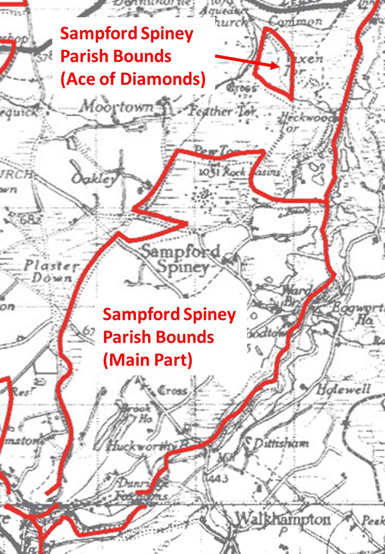
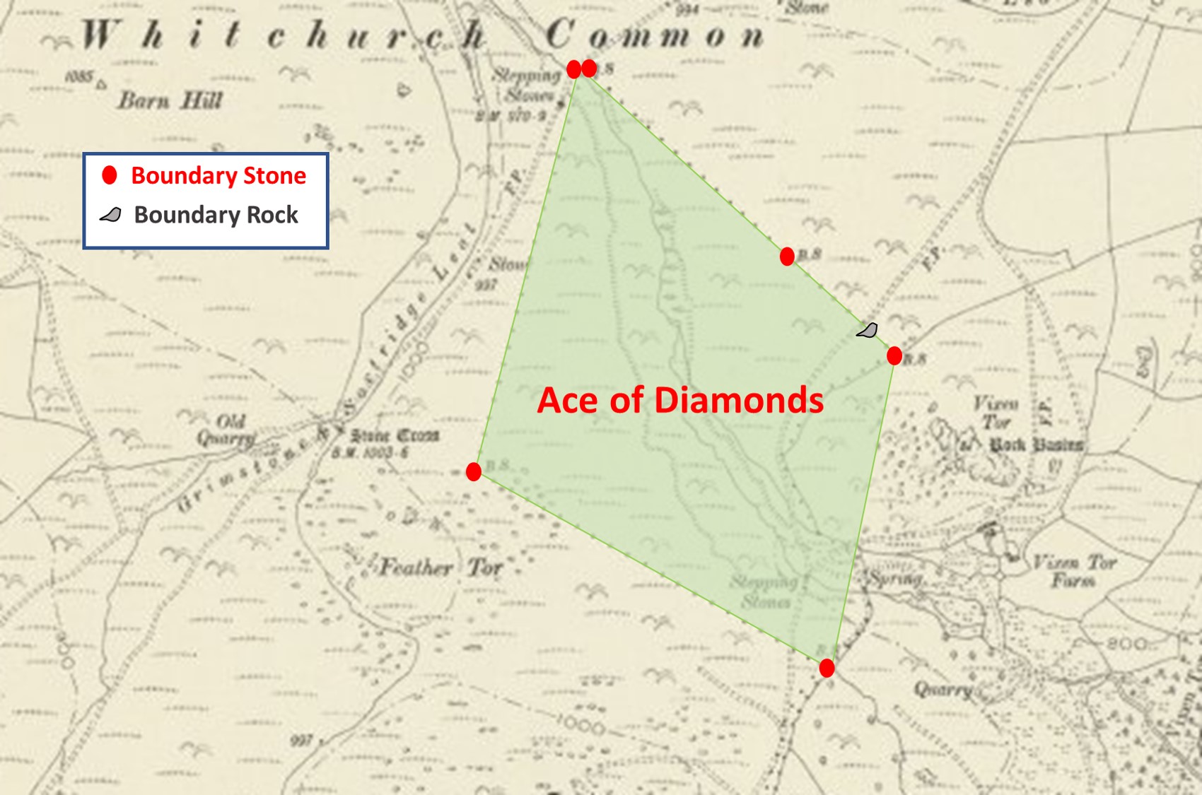
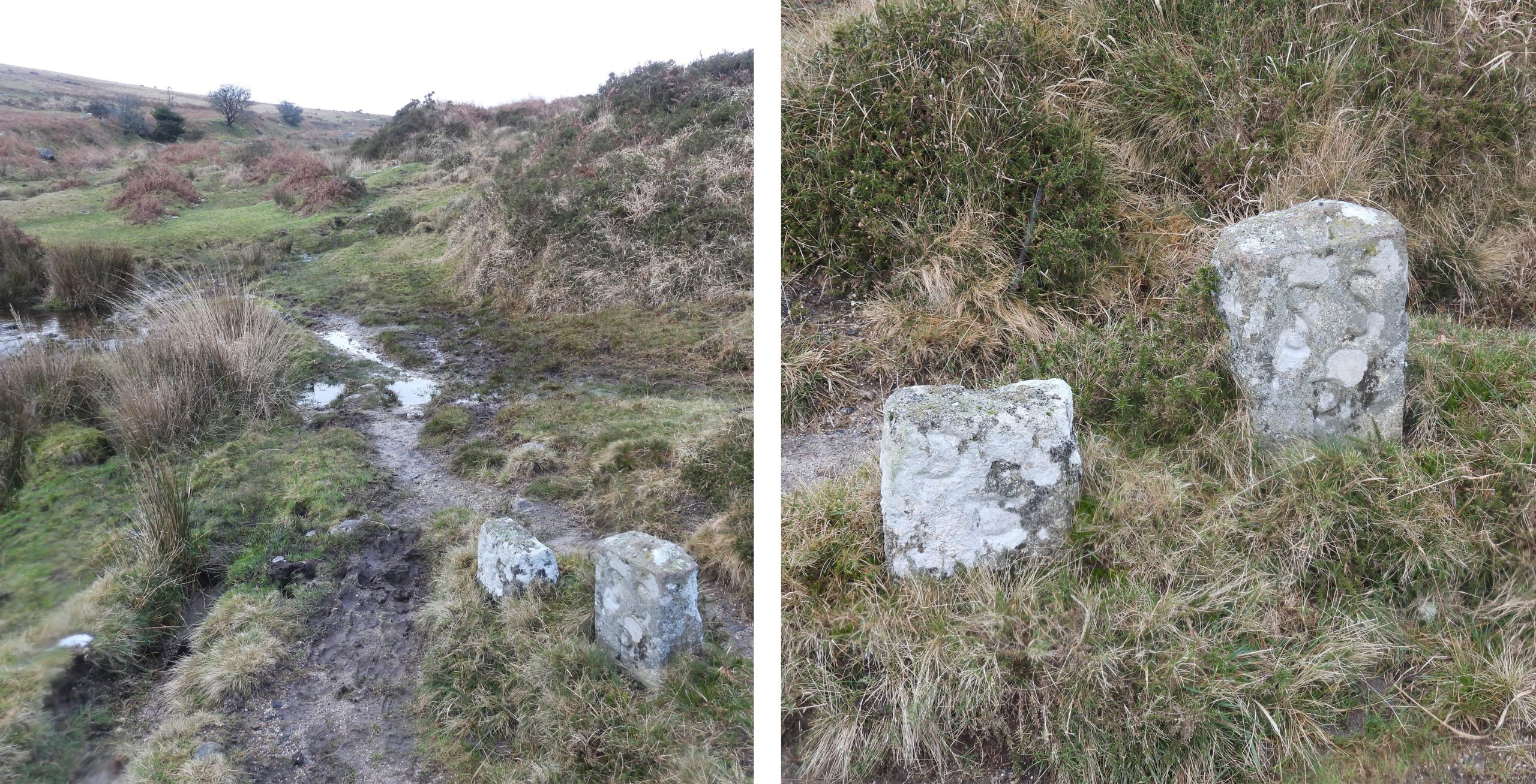
DARTMOOR EXPLORATIONS CALENDAR – APRIL
In 1991, the Dartmoor National Park Authority (DNPA) published a spiral bound diary to commemorate their fortieth anniversary (1951-1991), called “The Dartmoor Diary”.
Inspired by this publication (and some of the entries in it) and to celebrate the DNPA 70th anniversary year in 2021, the “Dartmoor Explorations Calendar” records an event or story, complemented with photographs for each day of the year.
This page of the Dartmoor Explorations Calendar celebrates April on Dartmoor and its immediate borderlands.
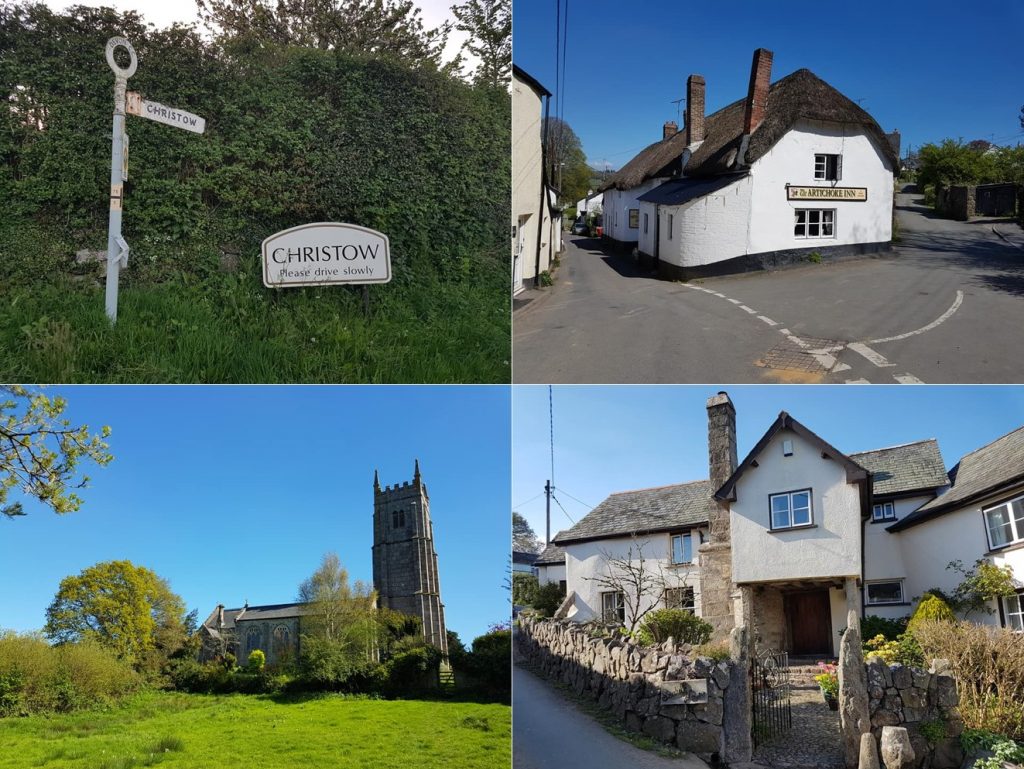
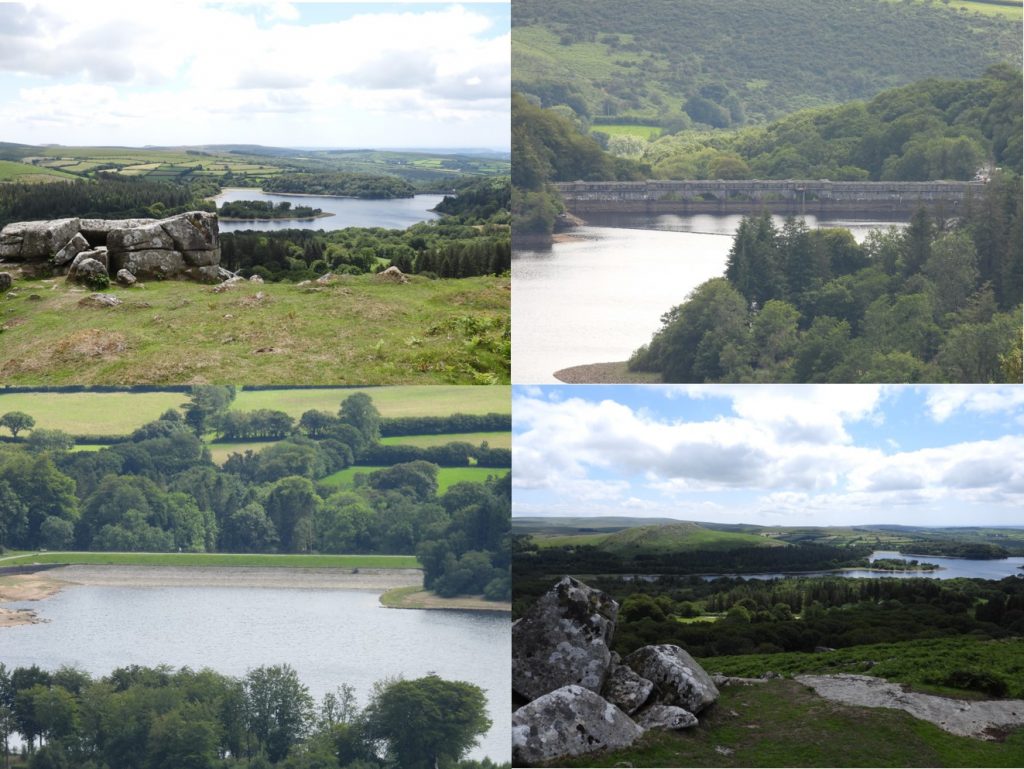
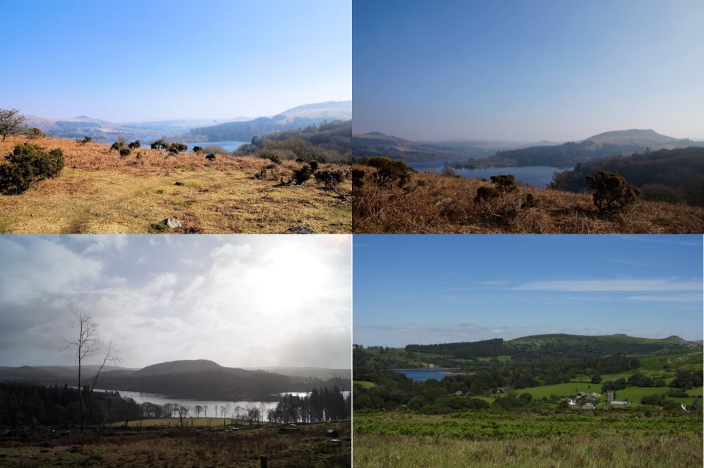
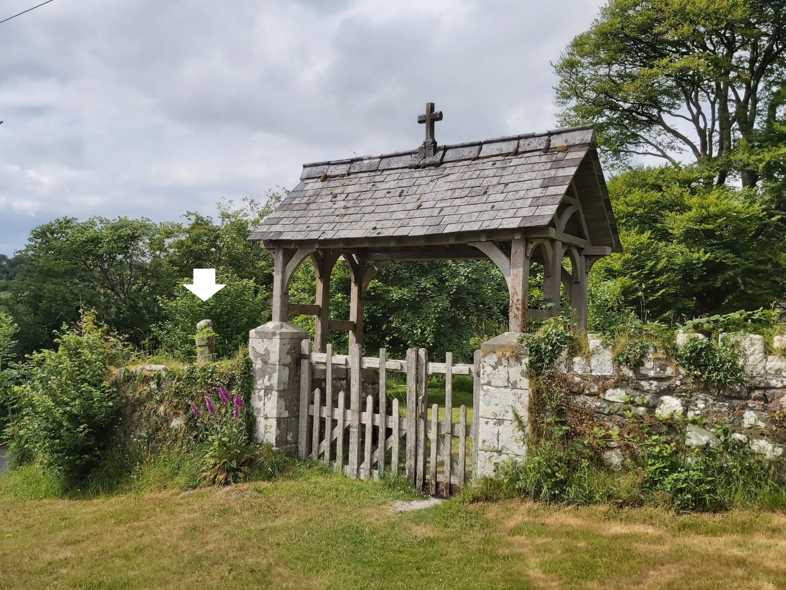
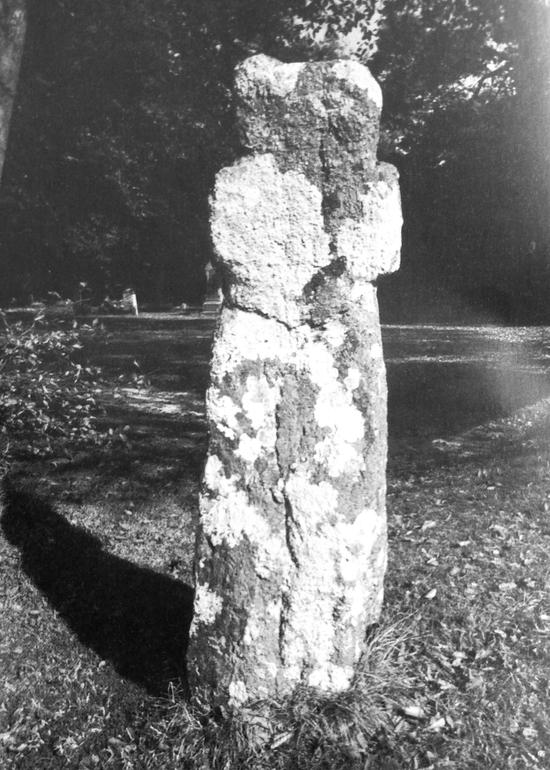
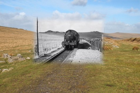
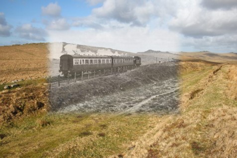
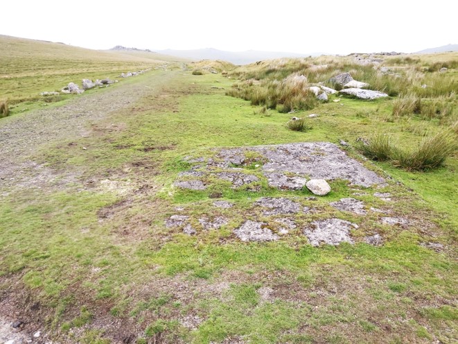
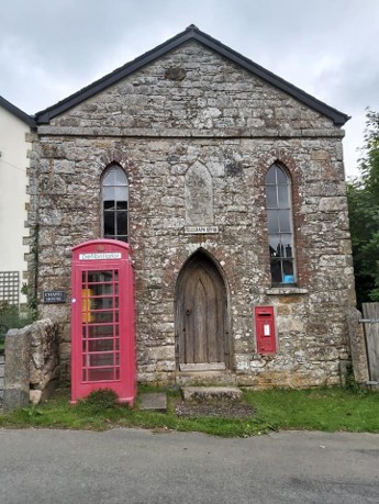
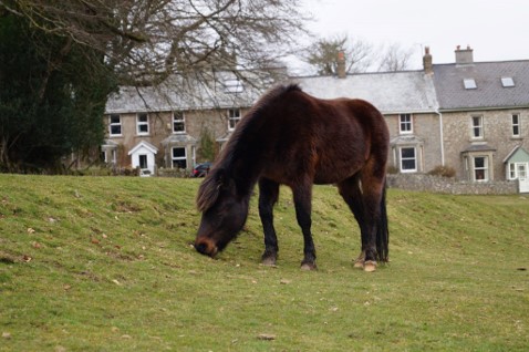
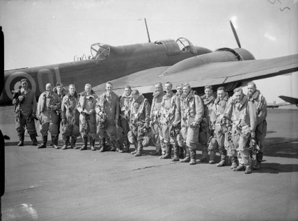
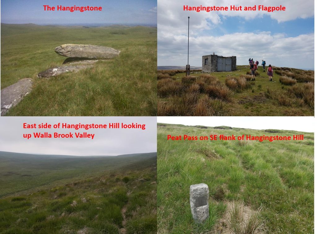
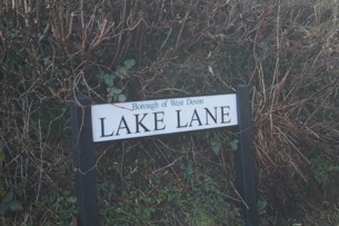
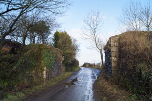
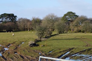
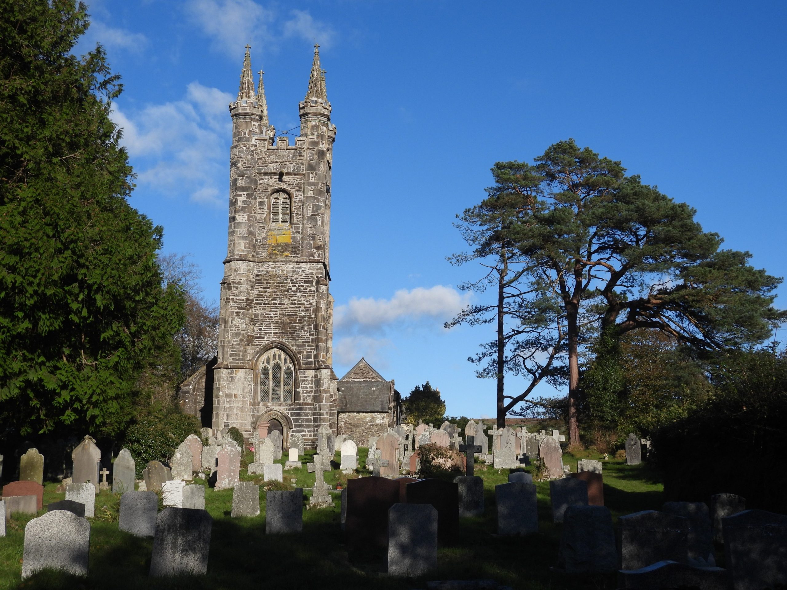
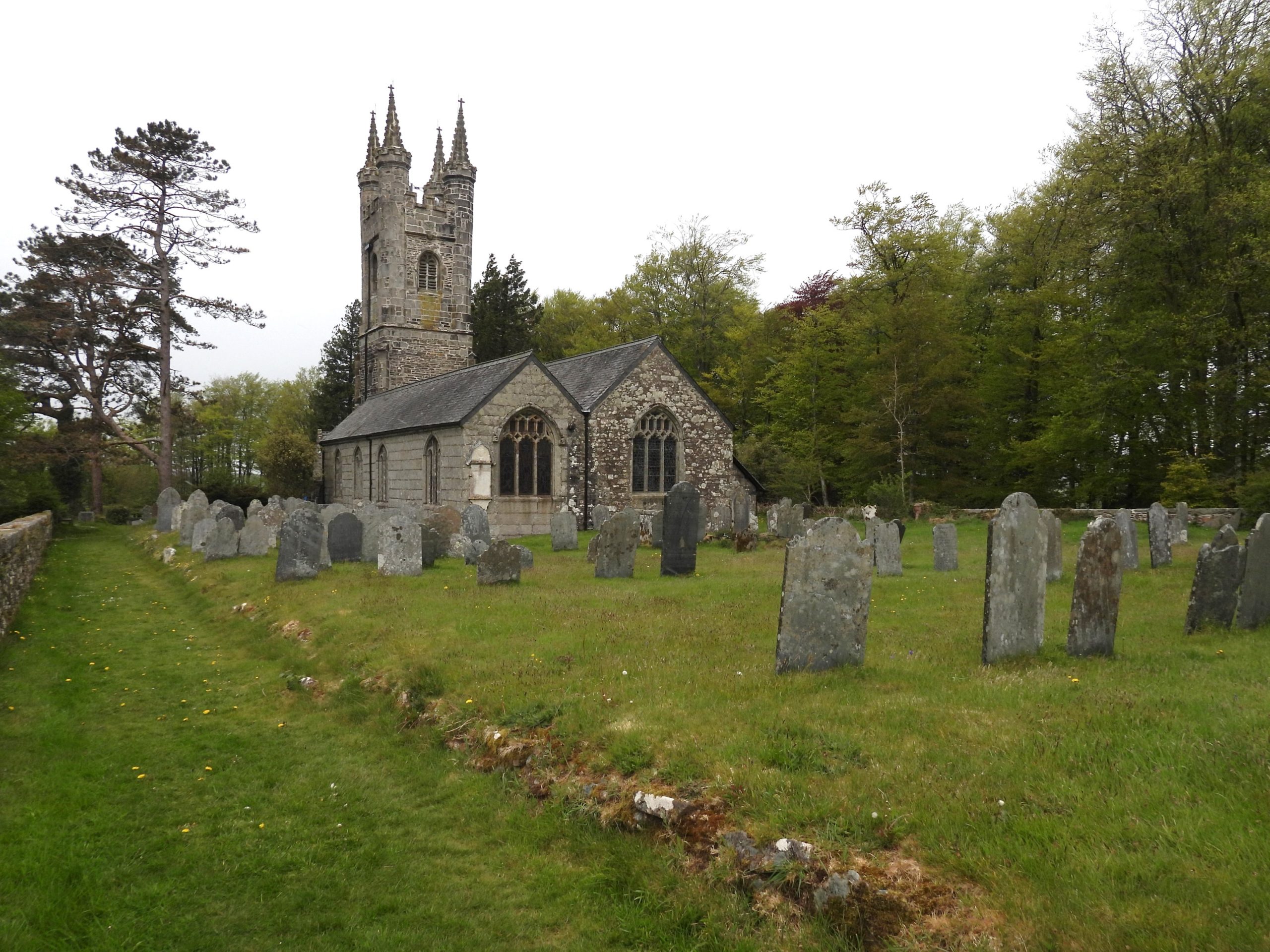
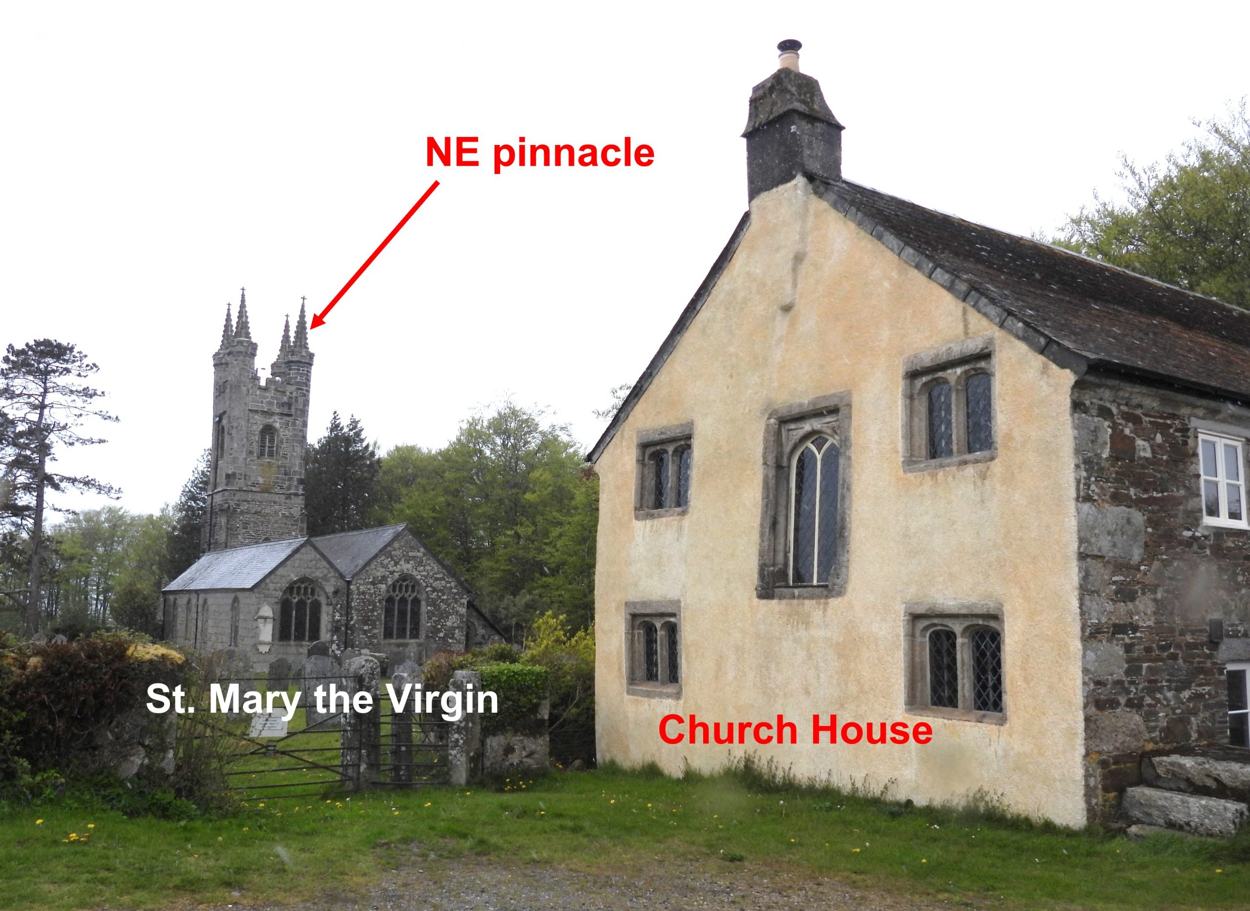
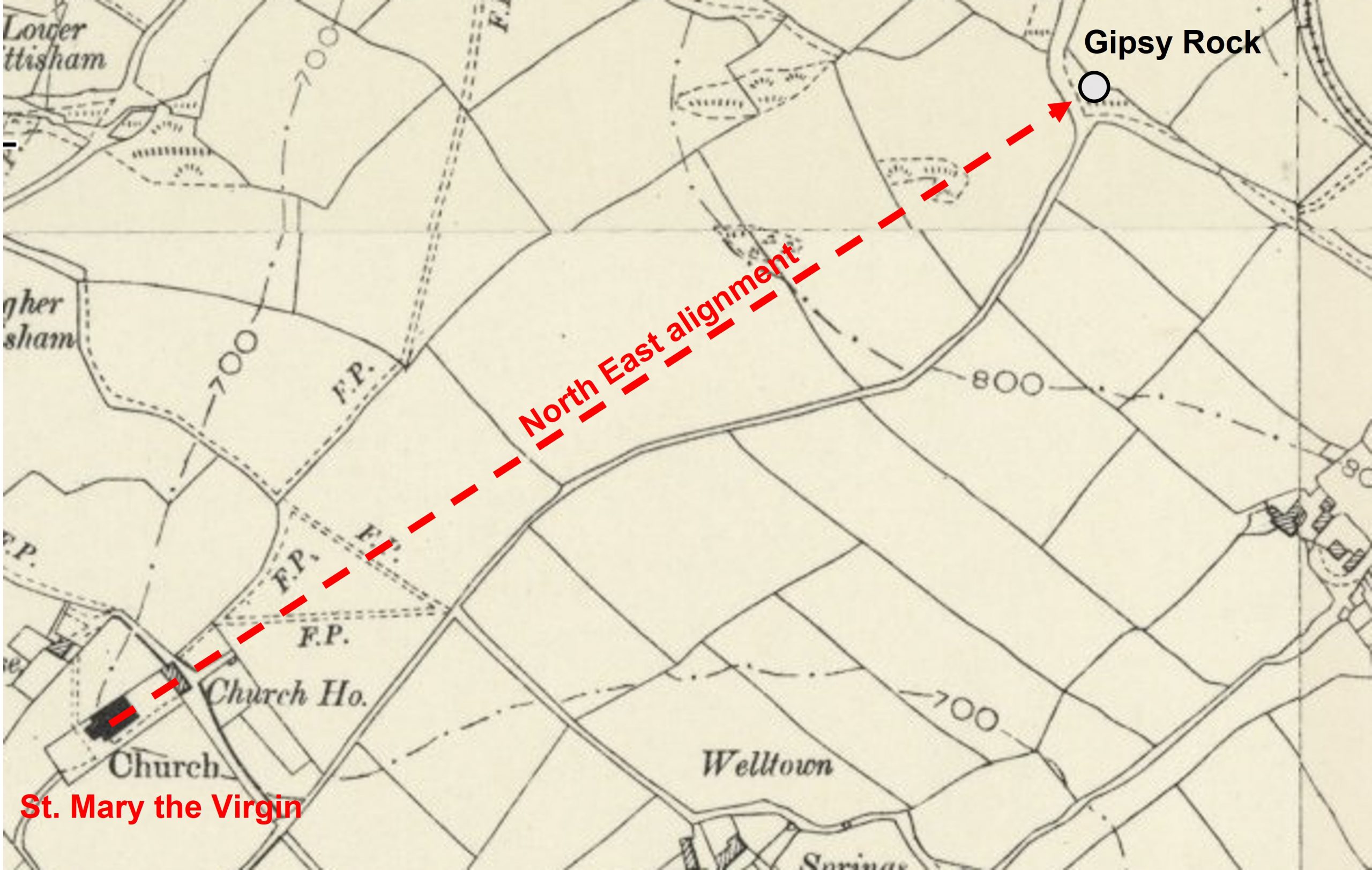
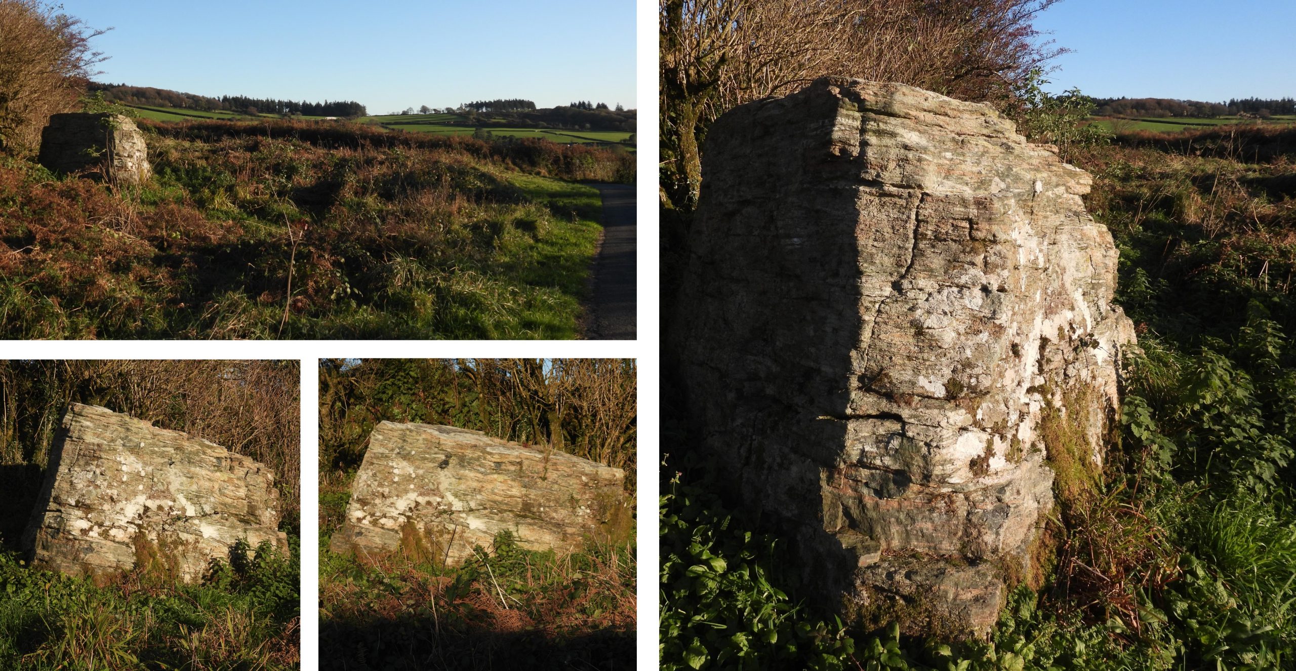
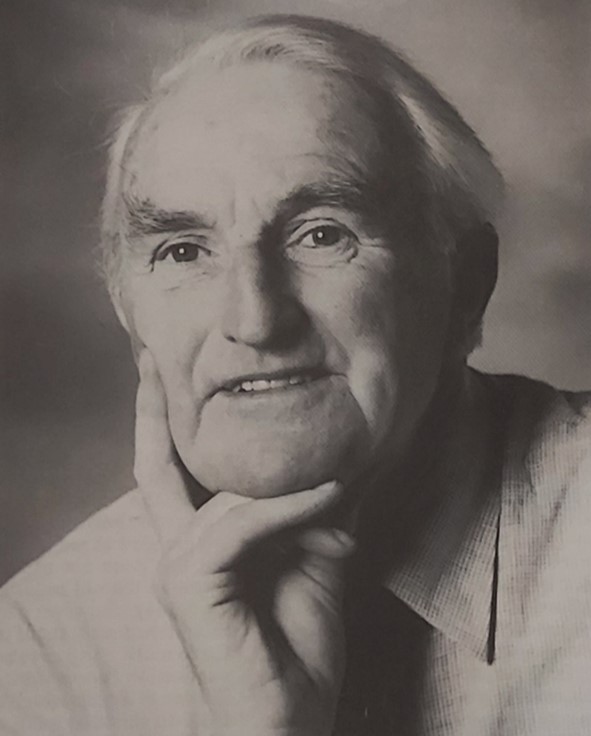
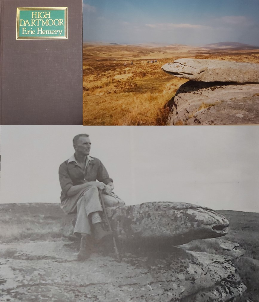
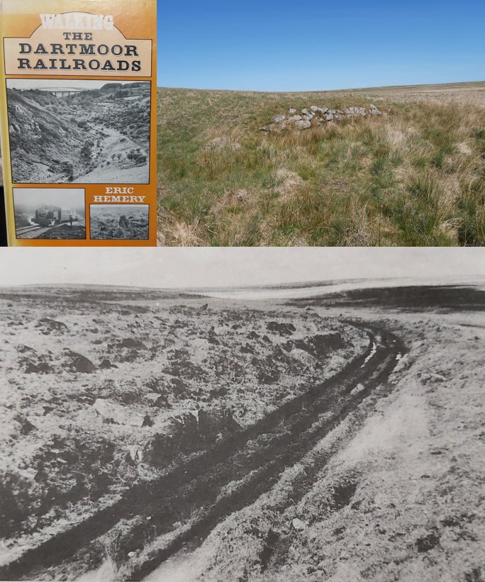
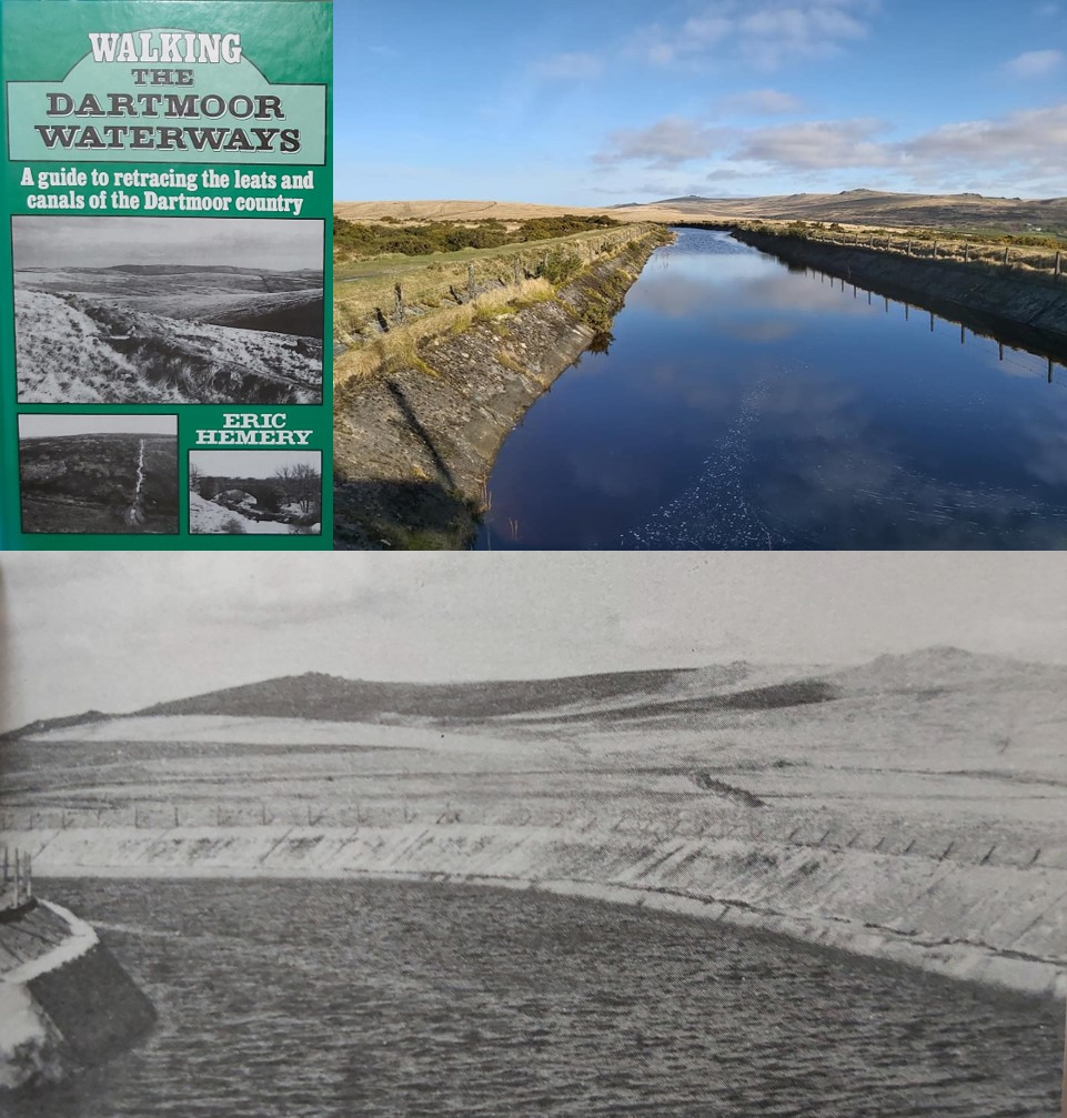
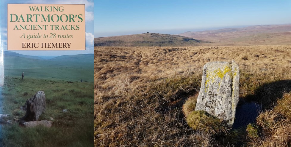
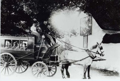
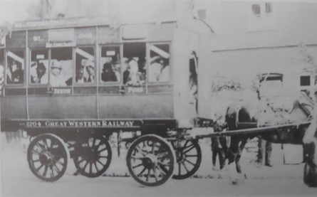
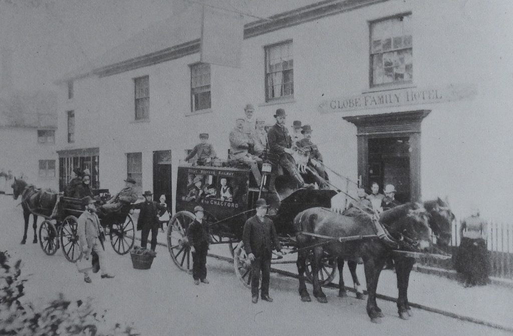
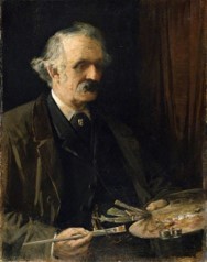
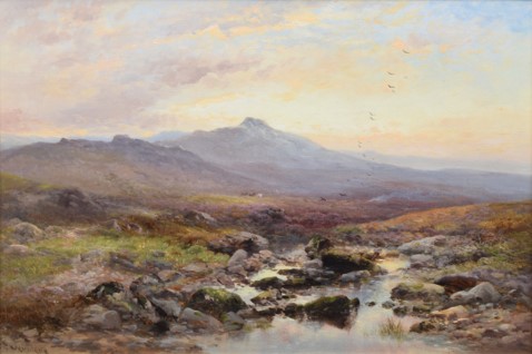
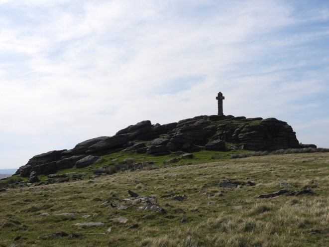
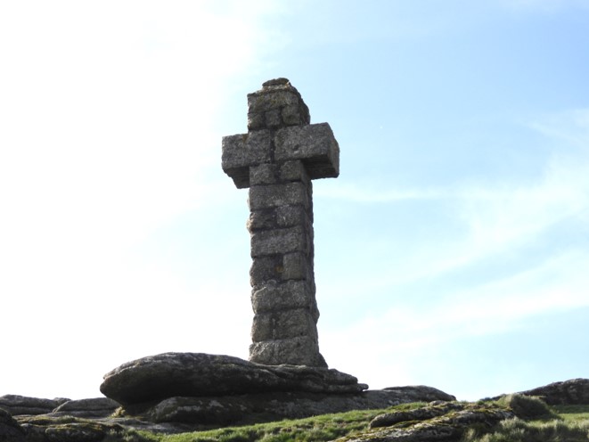
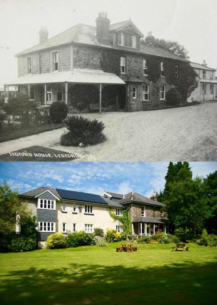
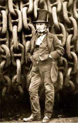
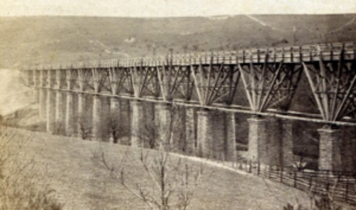
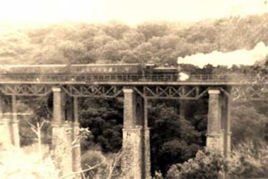
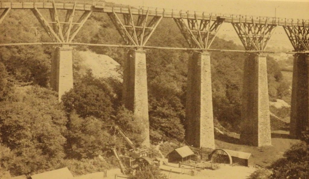
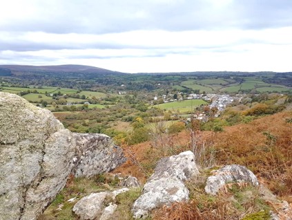
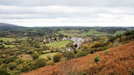
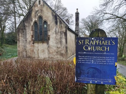
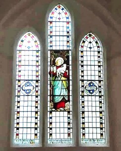
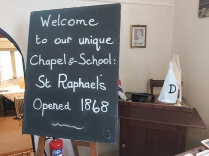
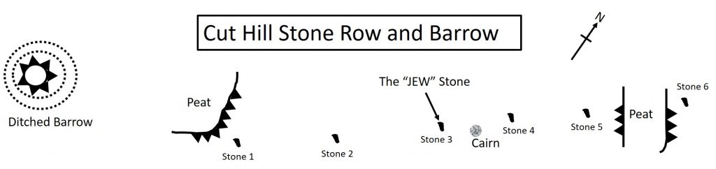
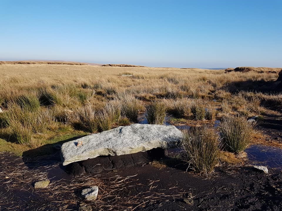
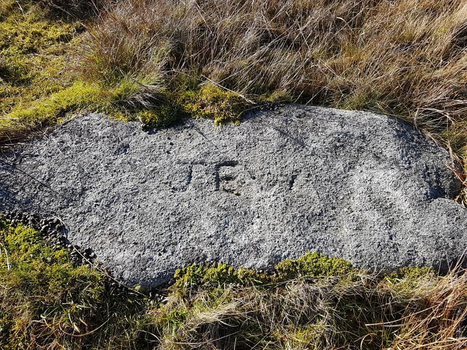
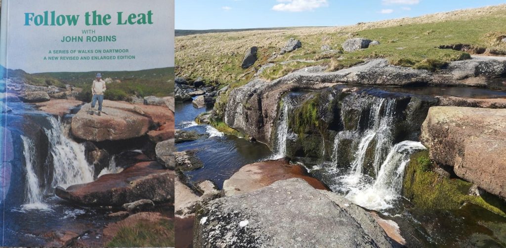
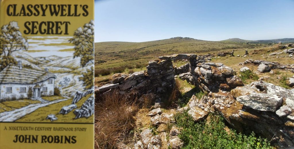
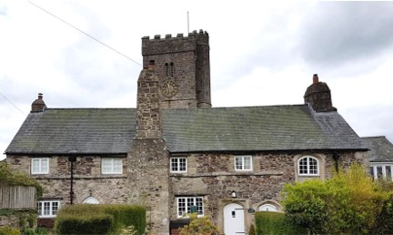
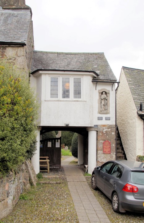
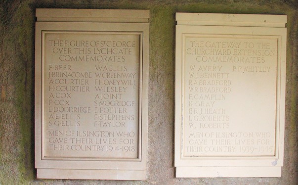
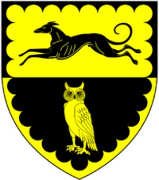
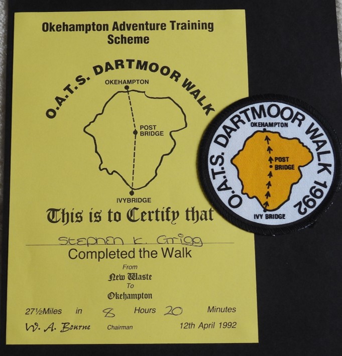
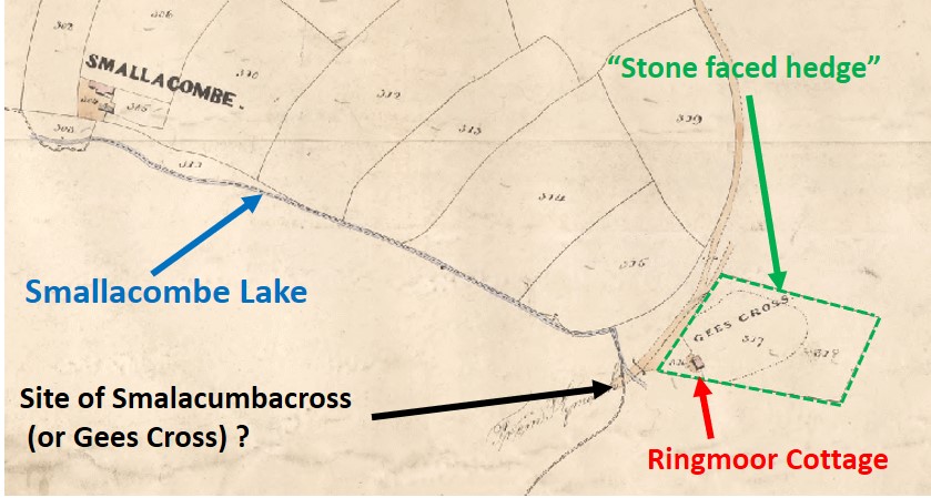
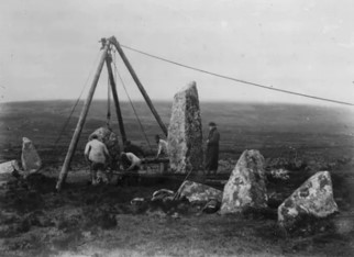
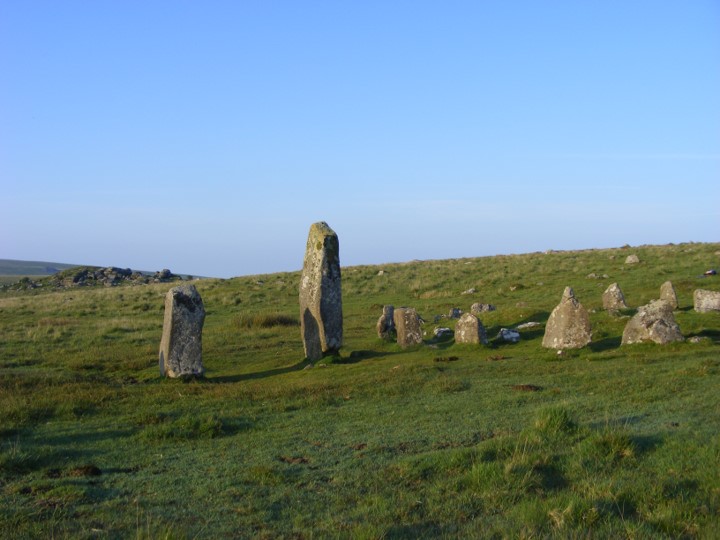
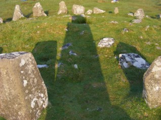
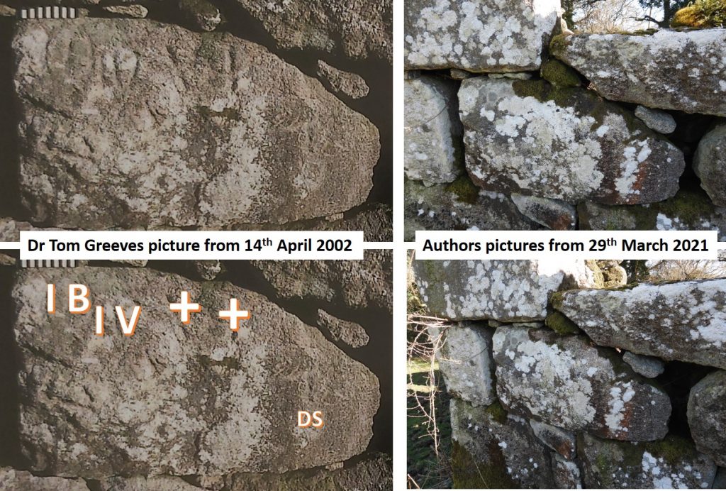
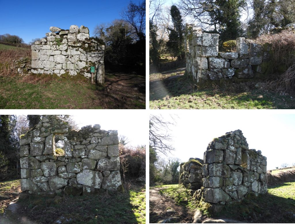
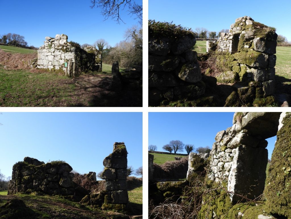
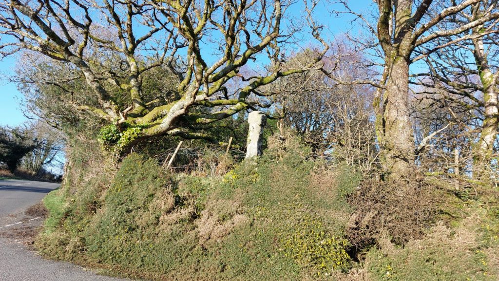
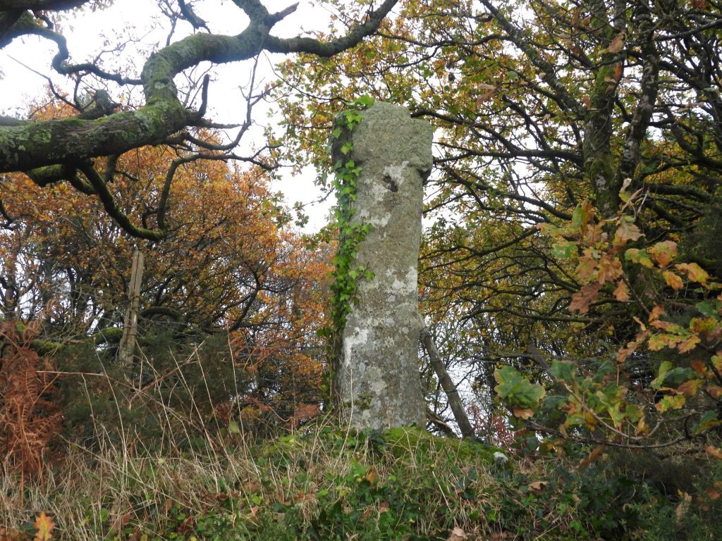
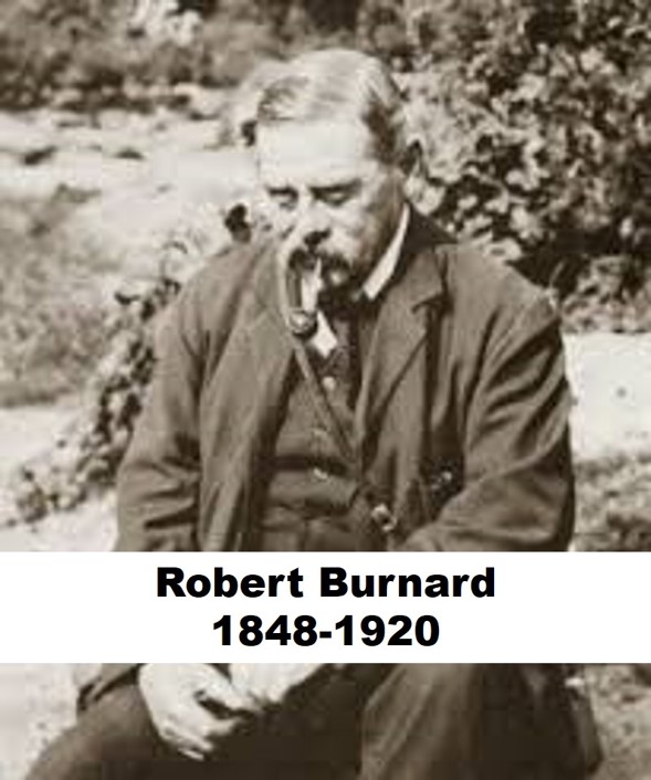
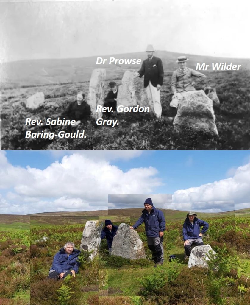
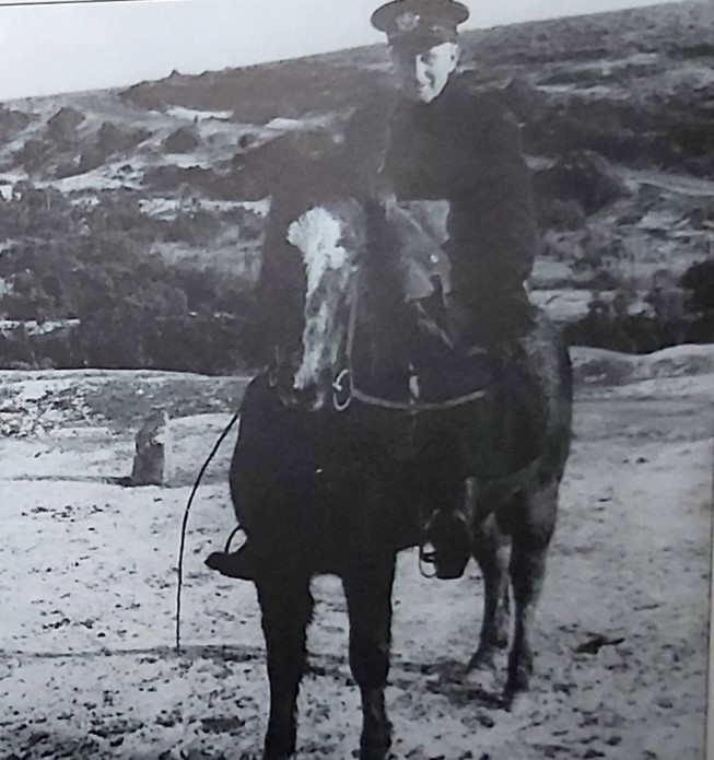
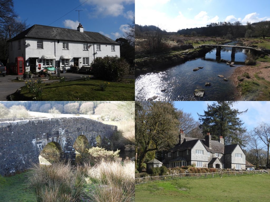
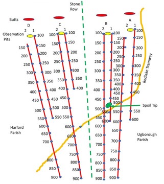
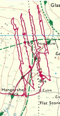
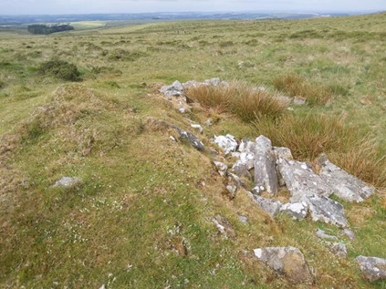
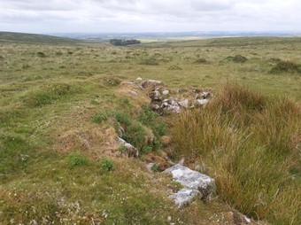
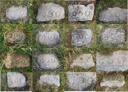
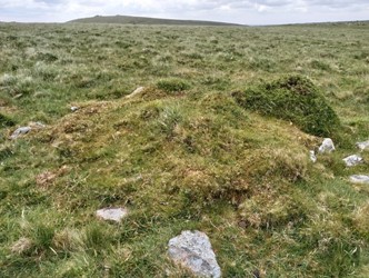
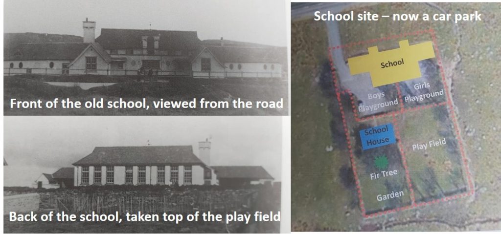
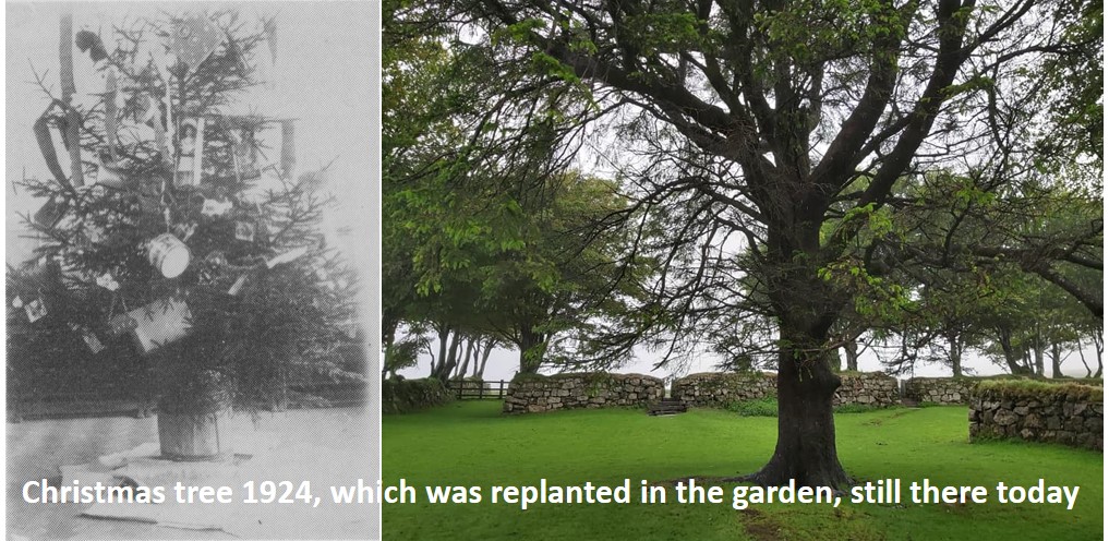
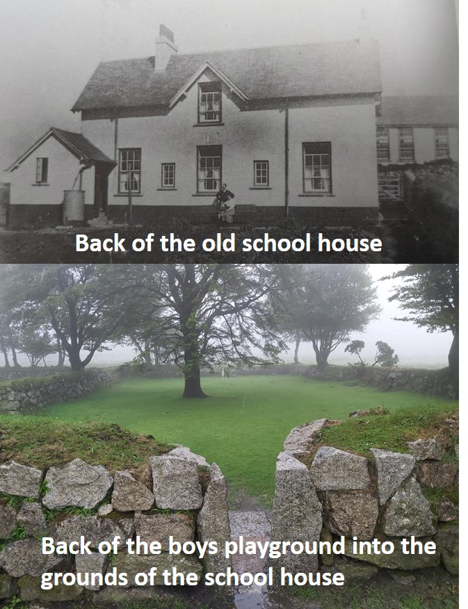
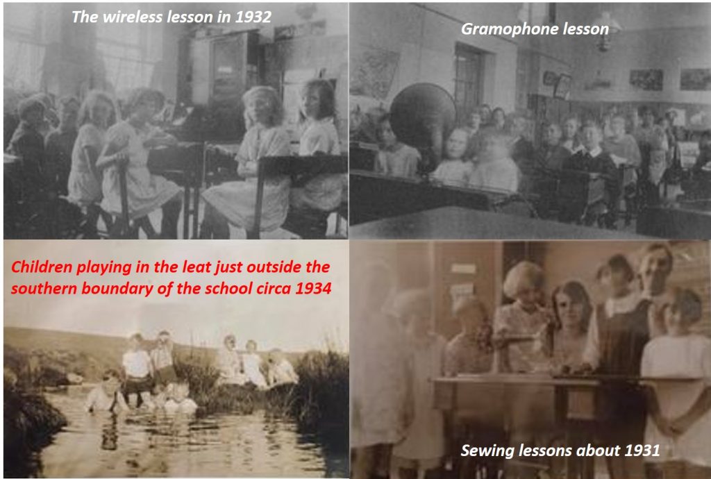
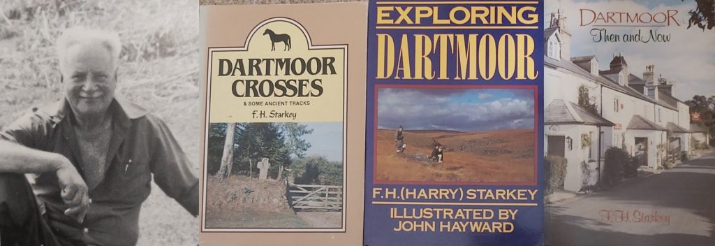
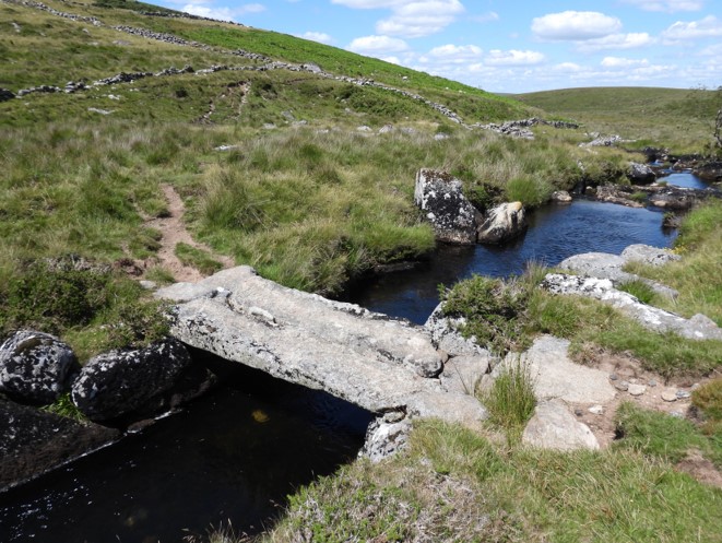
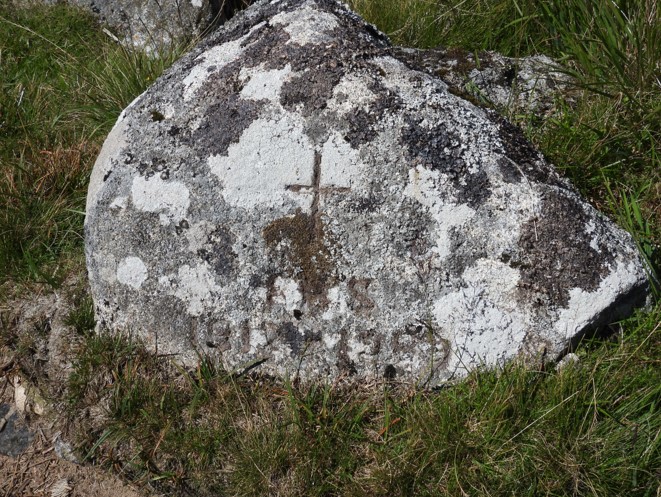
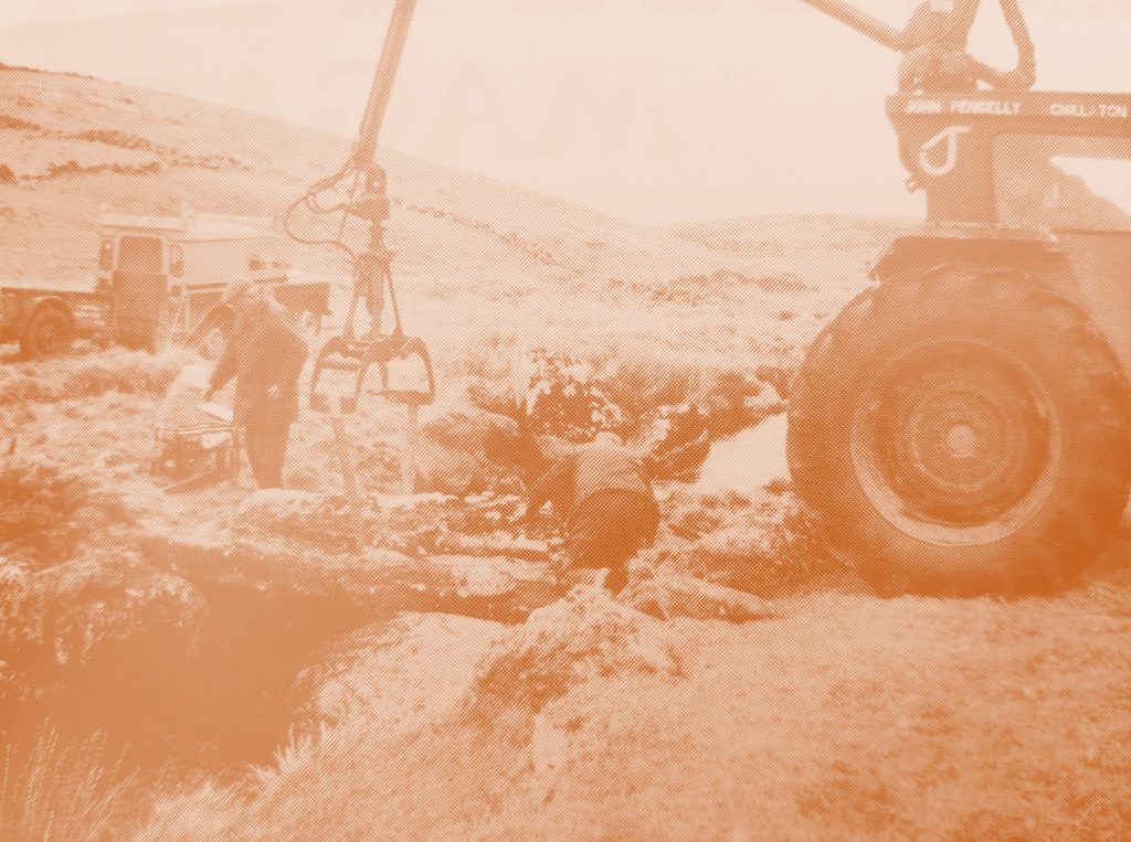
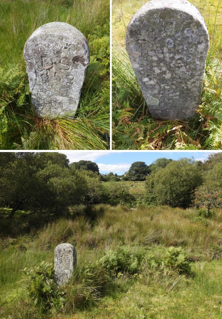
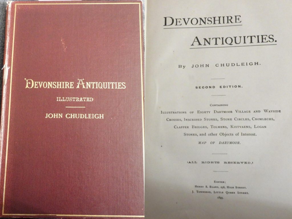
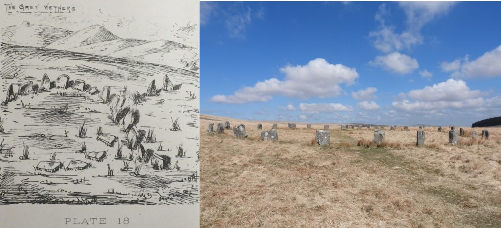
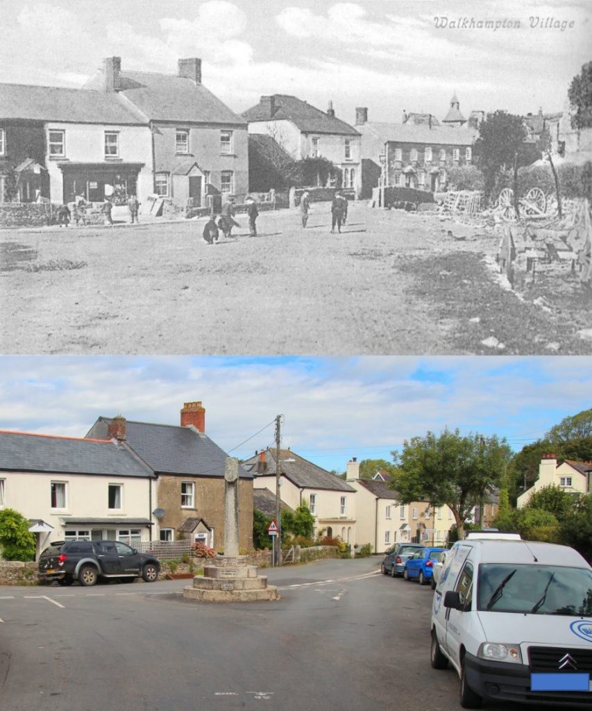
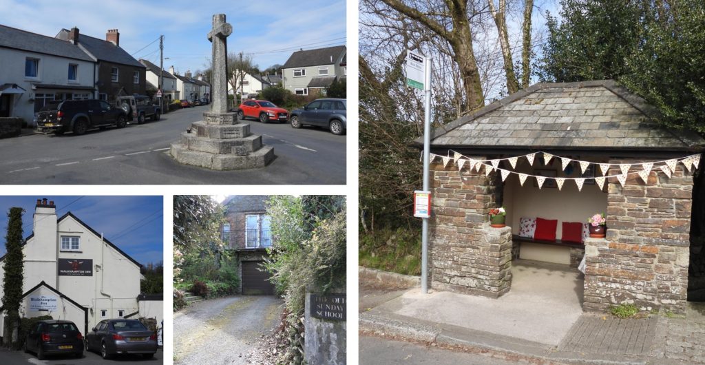
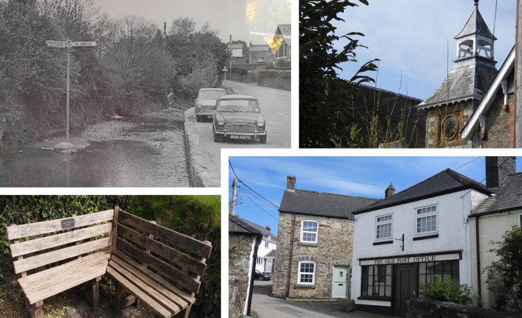
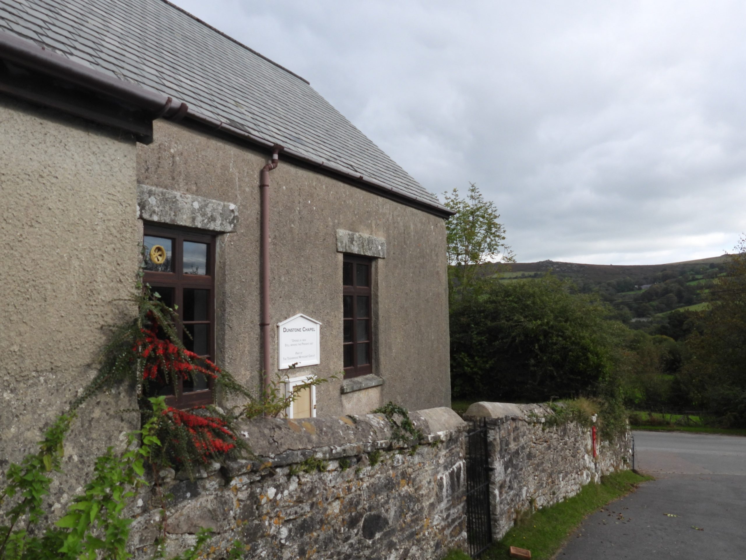
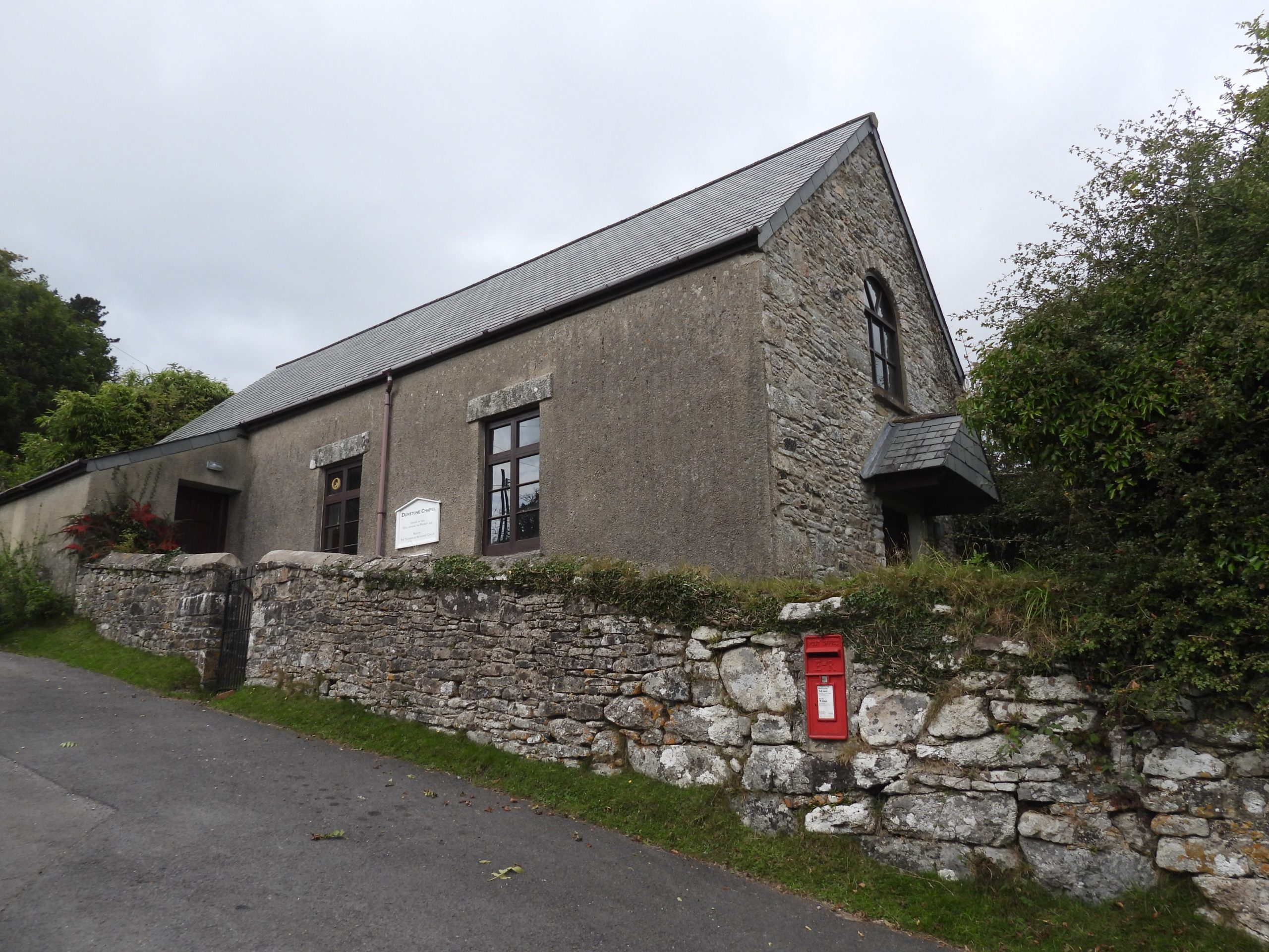
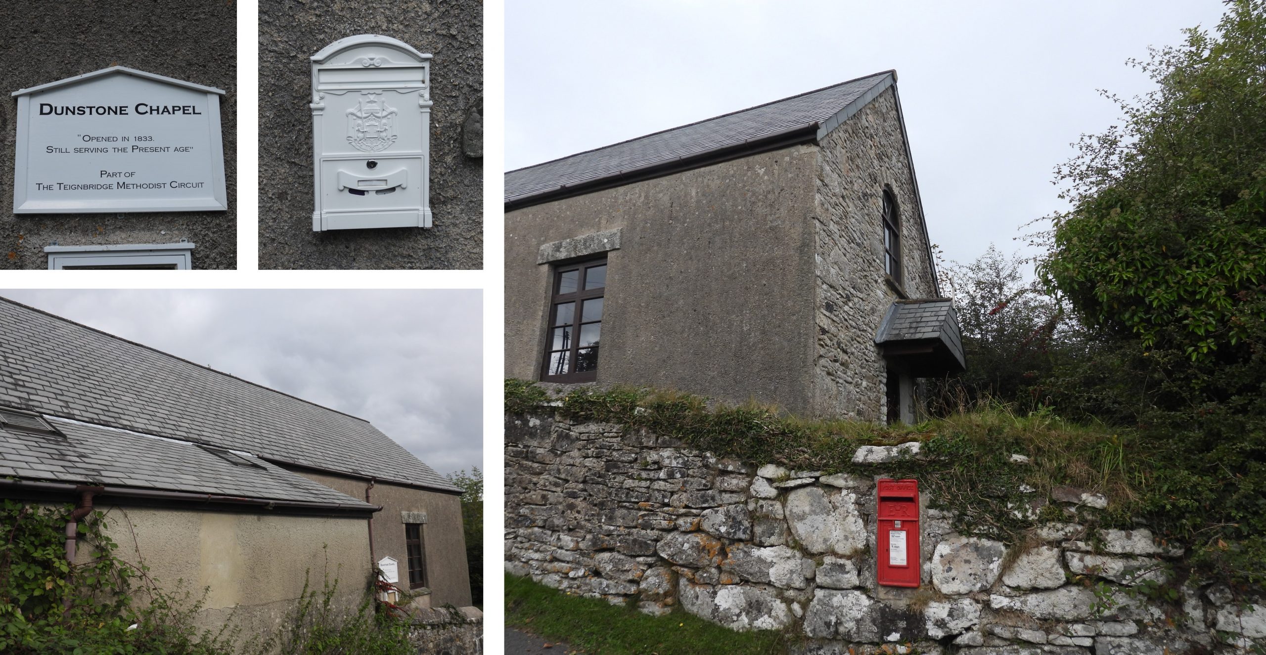
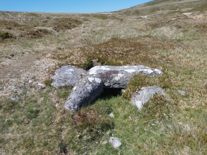
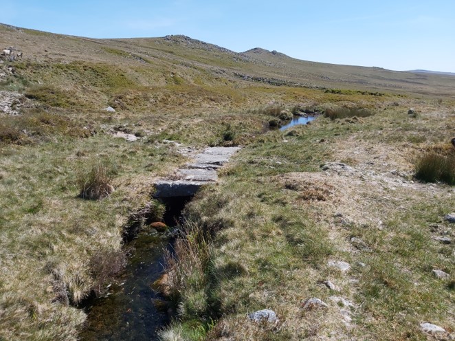
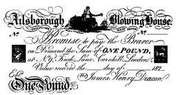
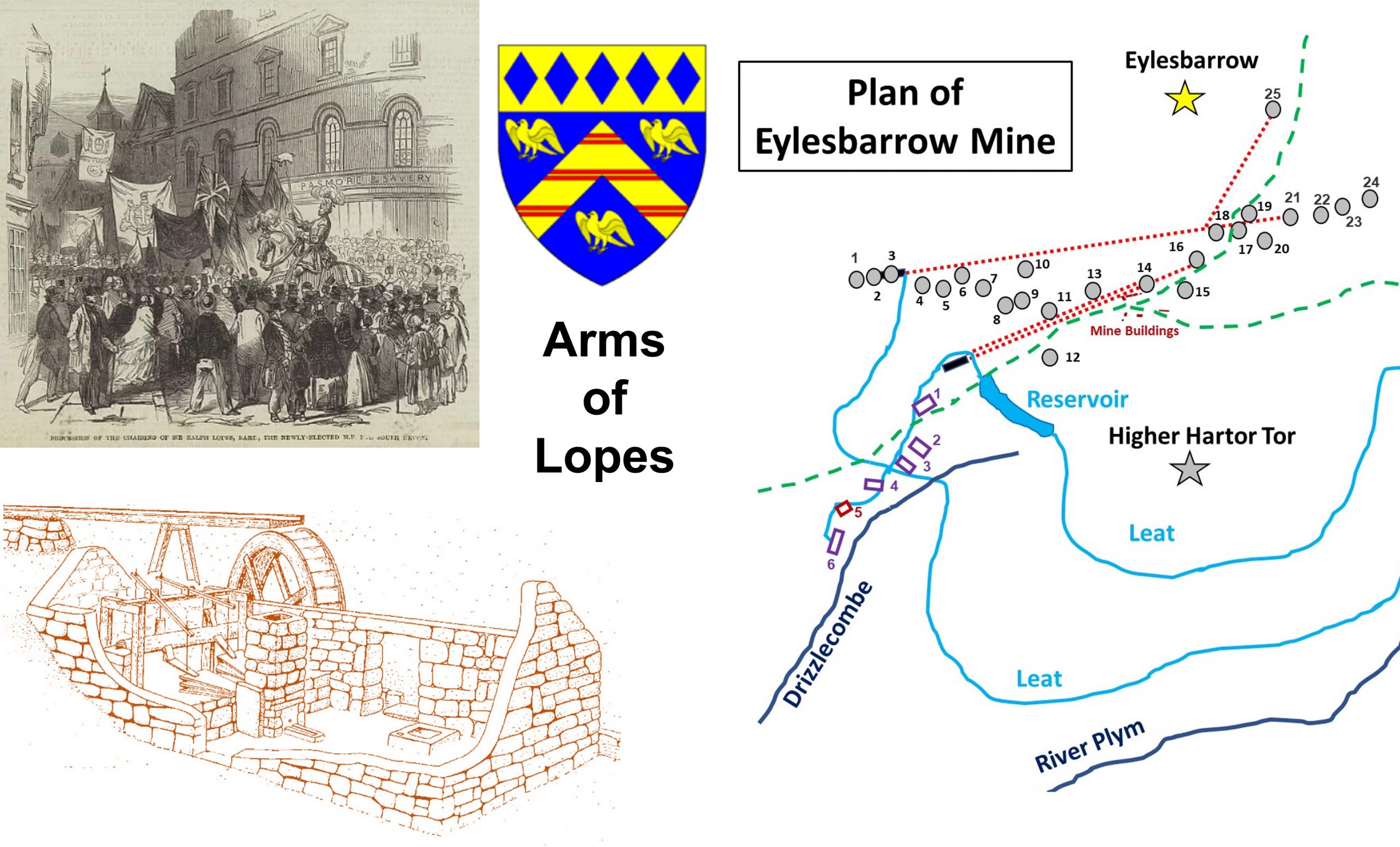
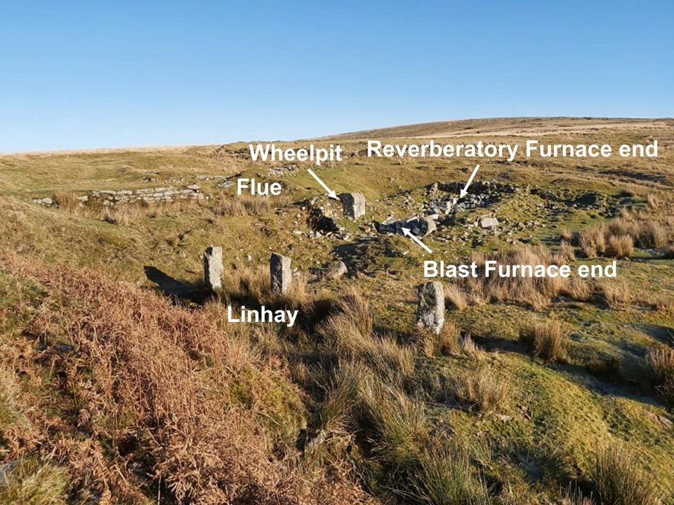
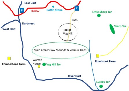
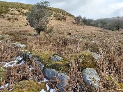
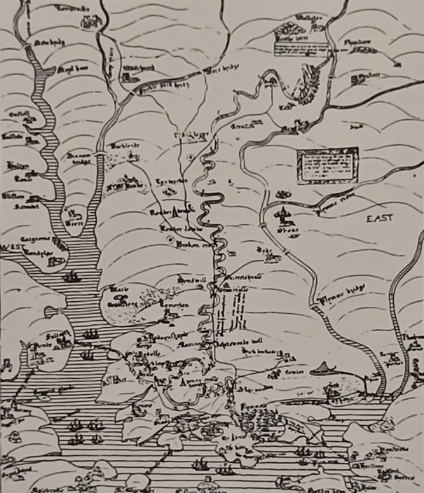
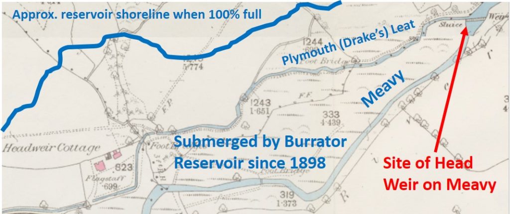
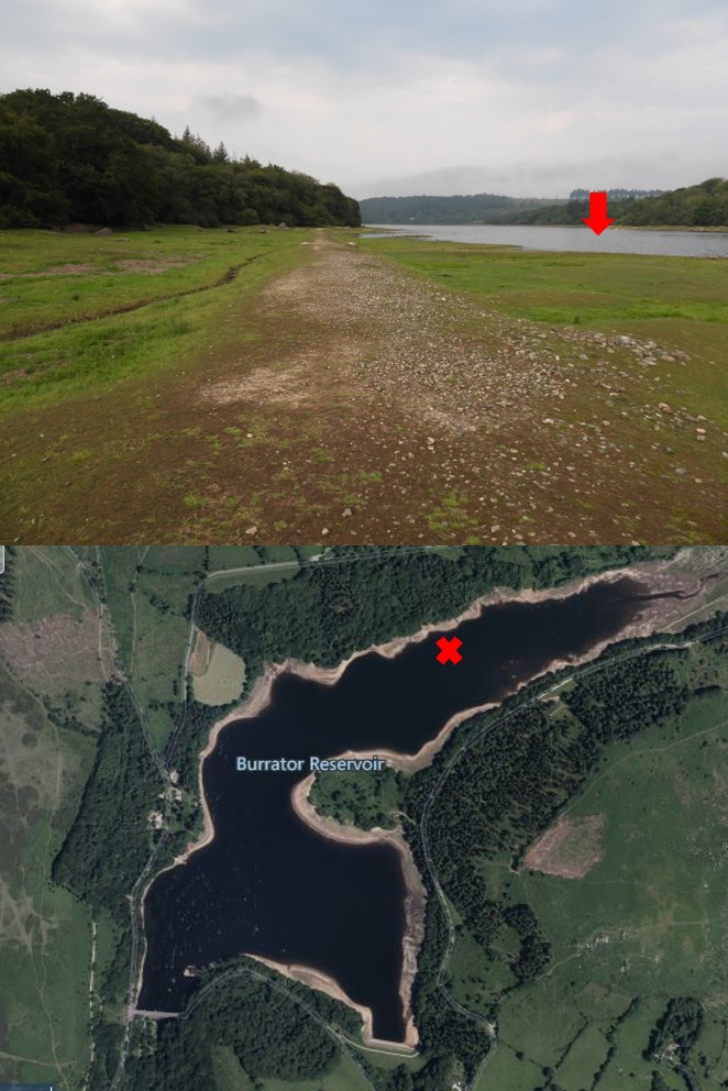
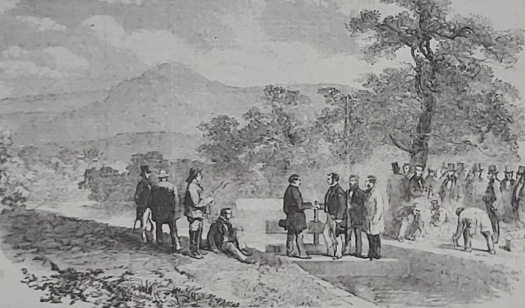
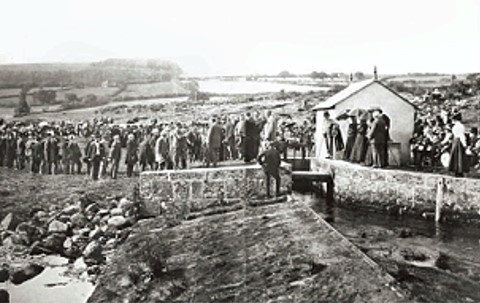
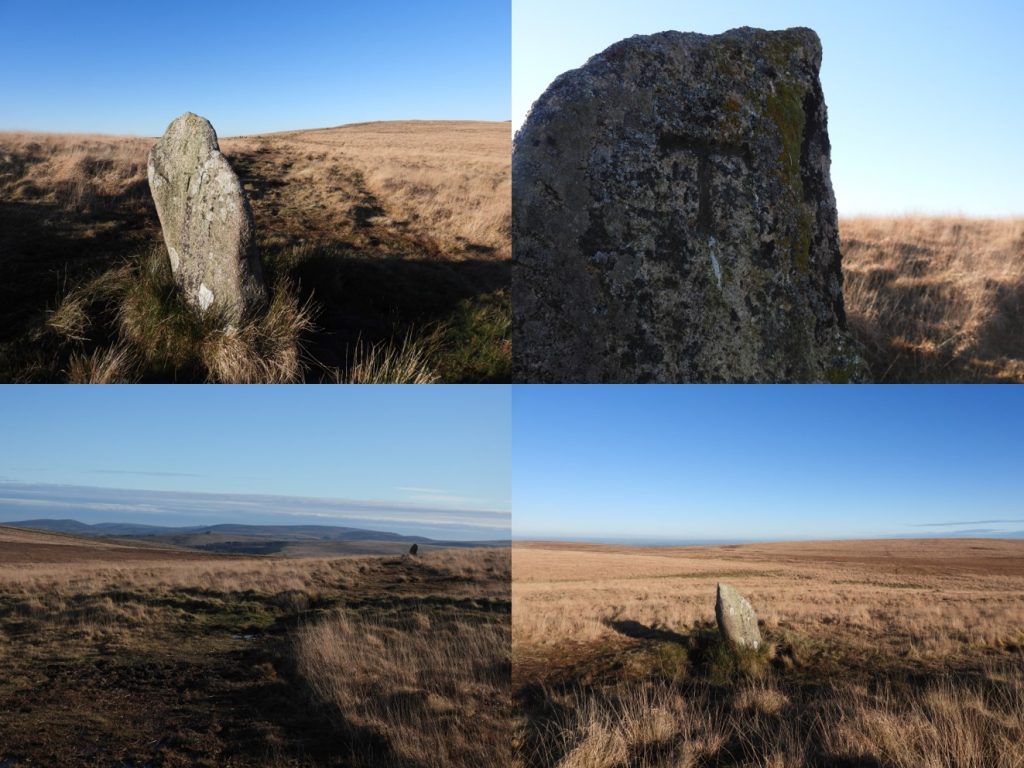
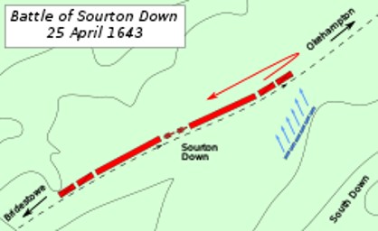
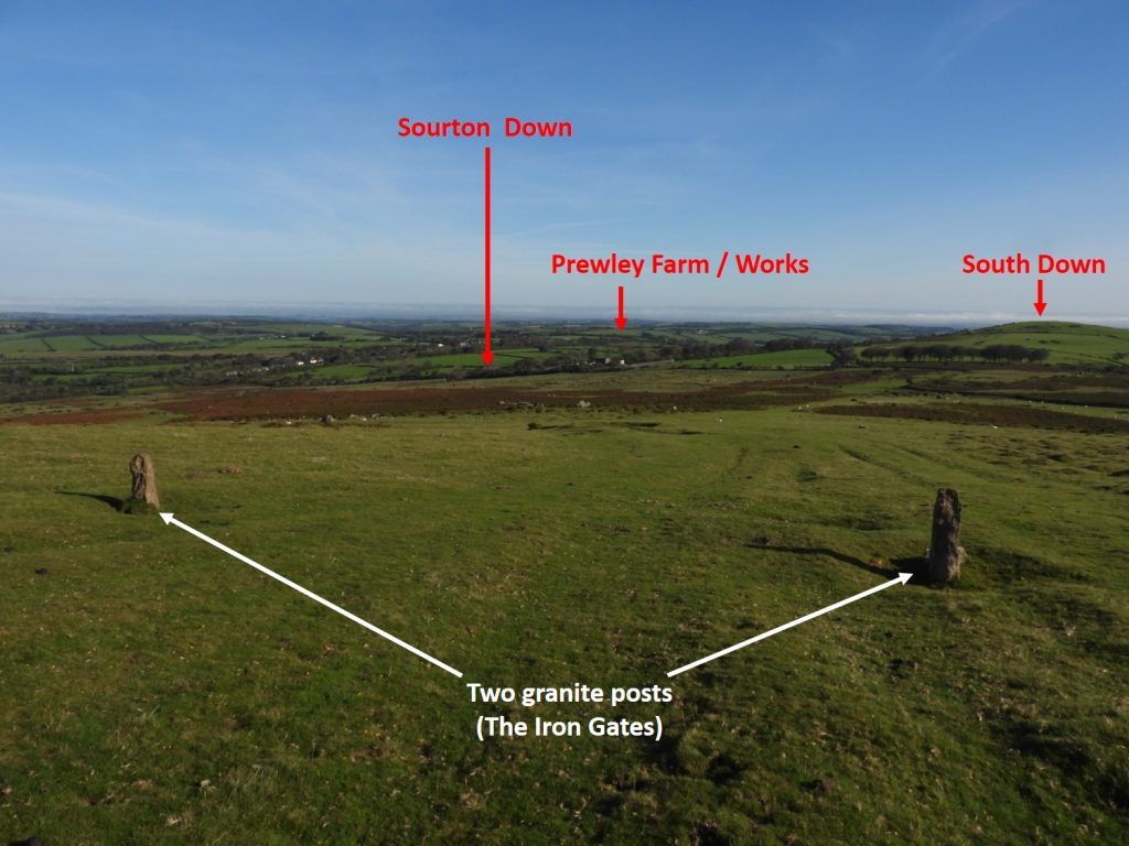
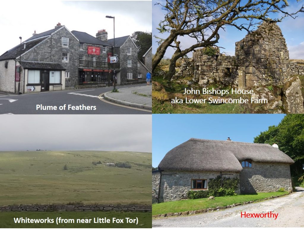
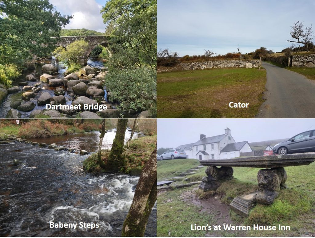
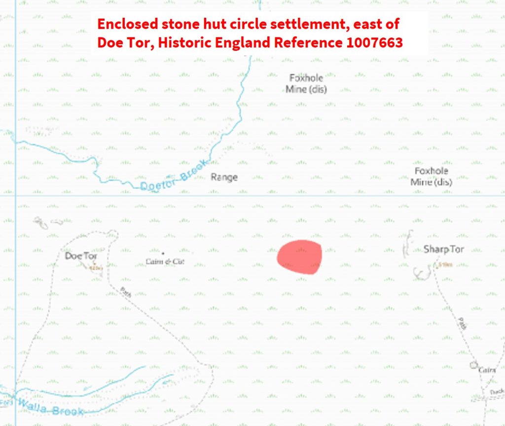
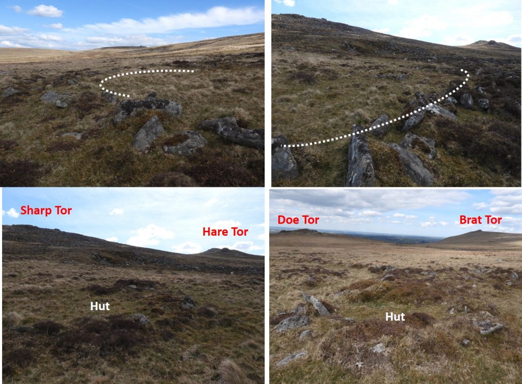
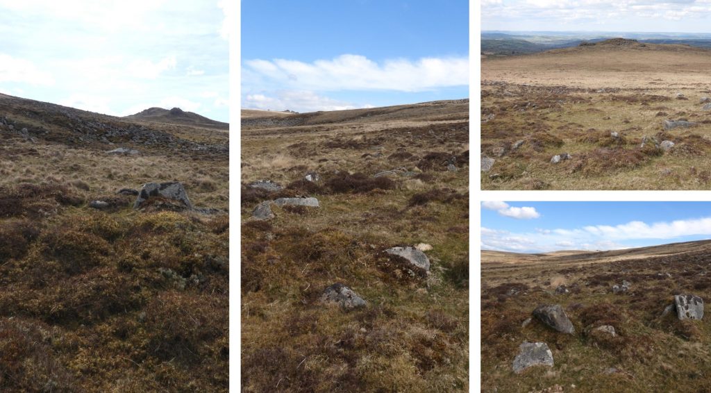
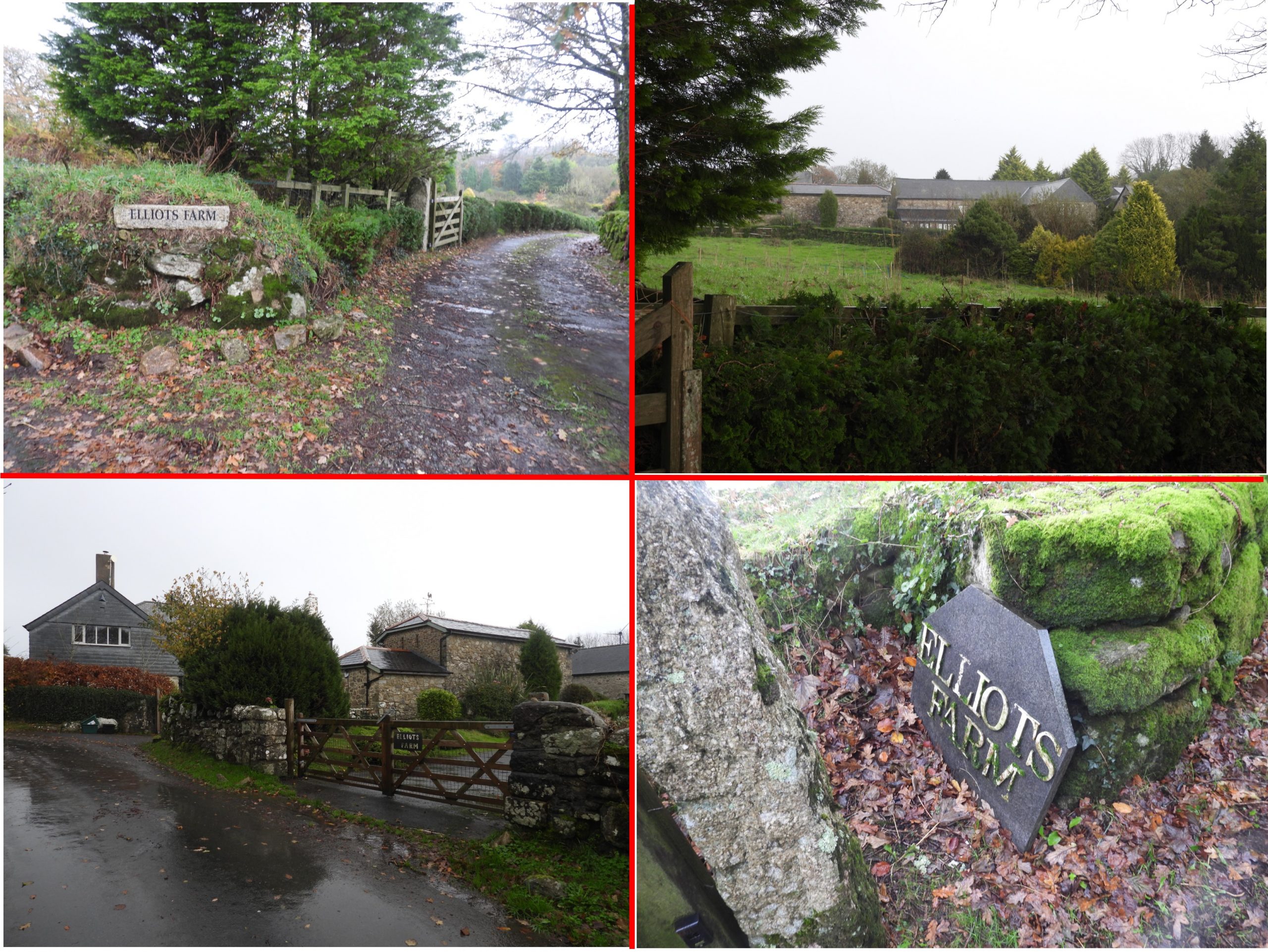
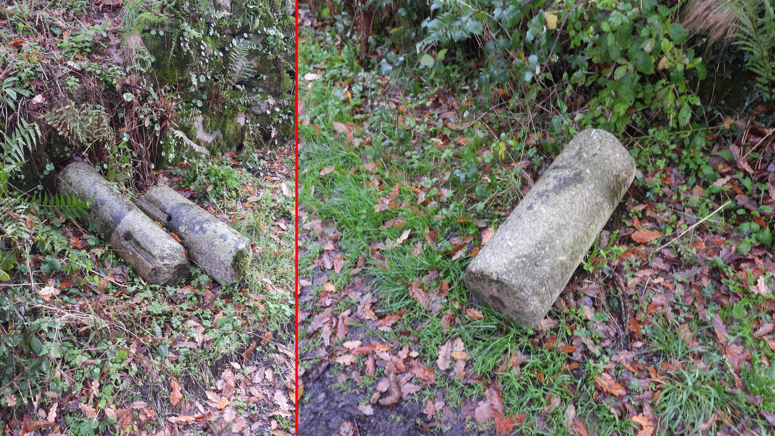
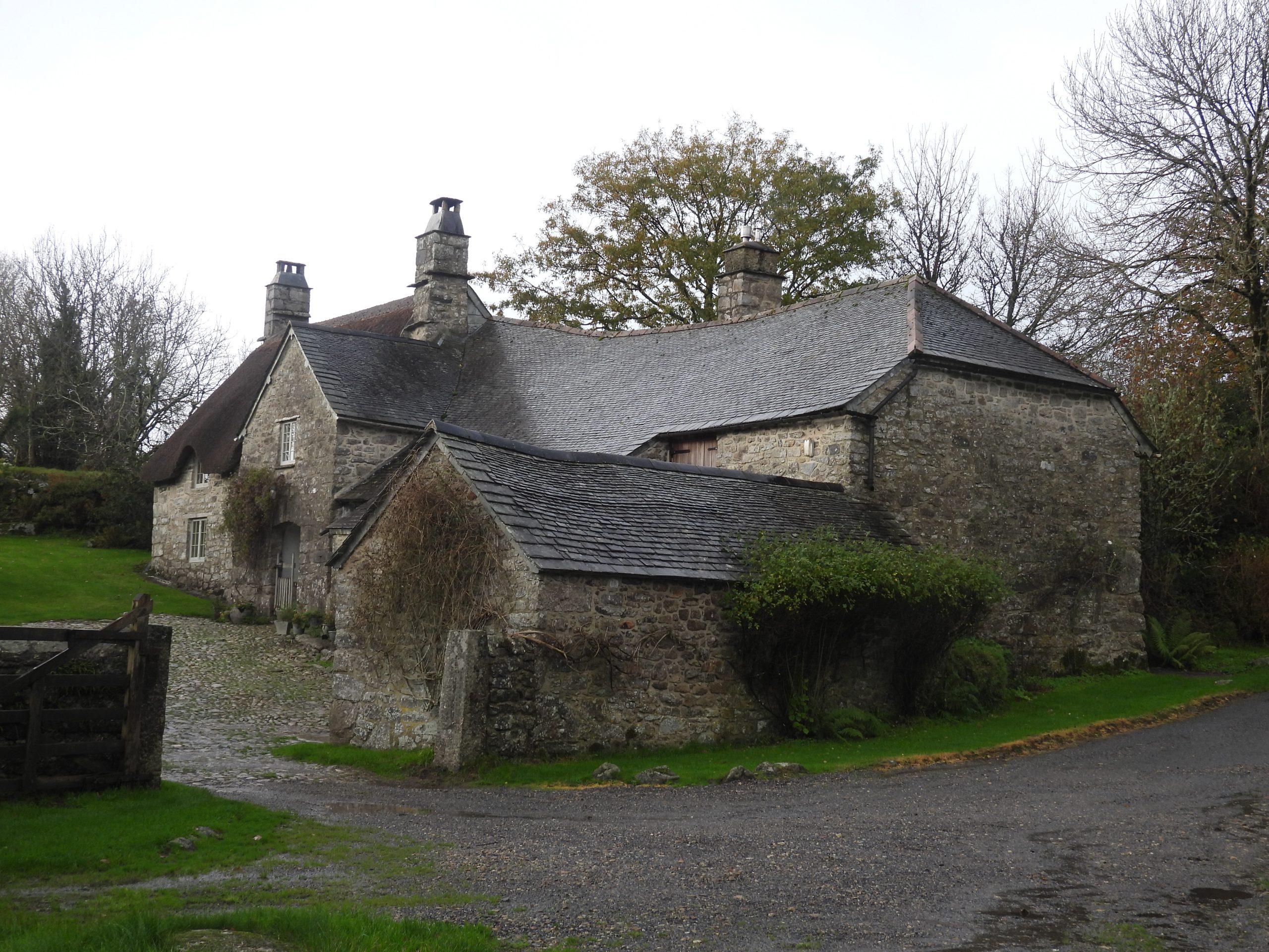
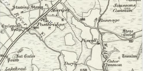
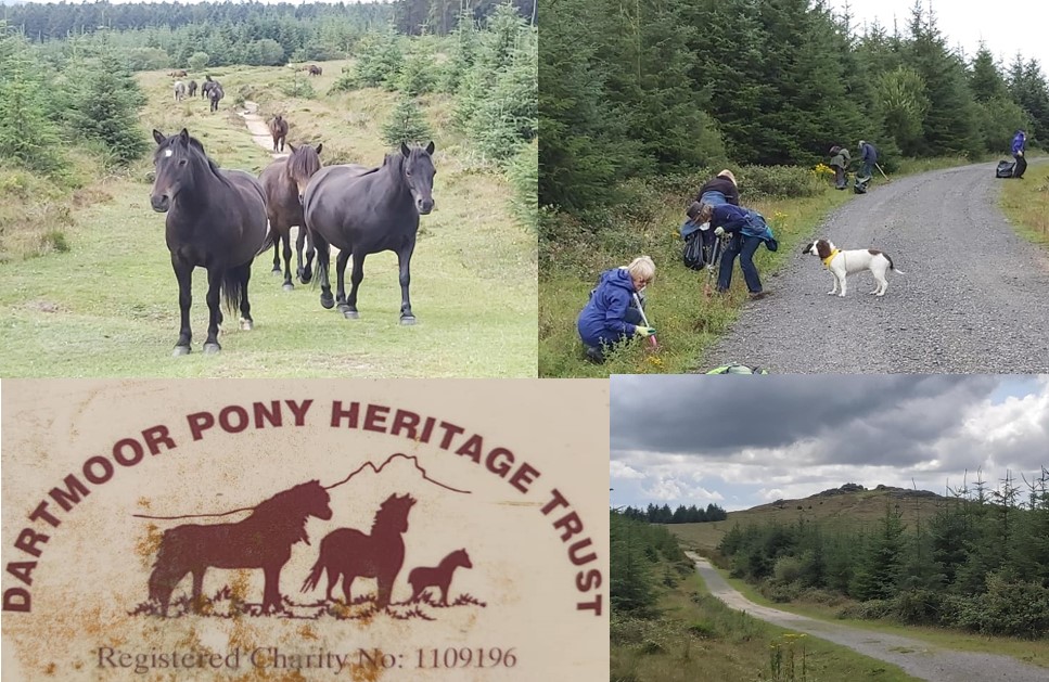
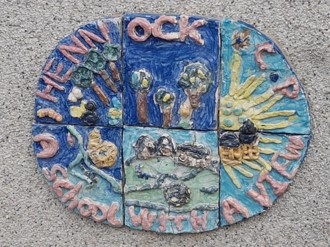
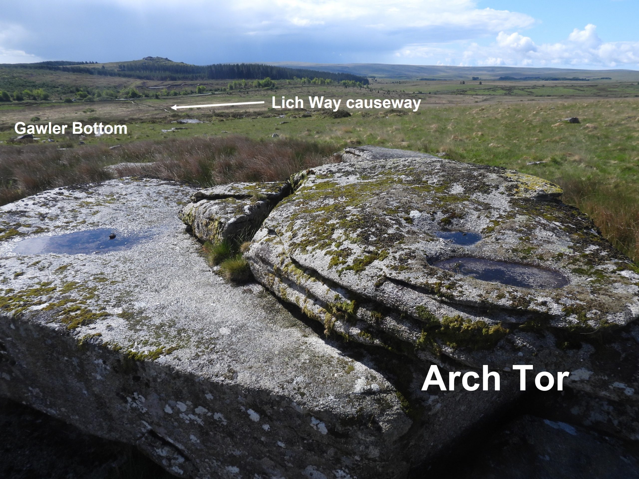
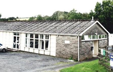
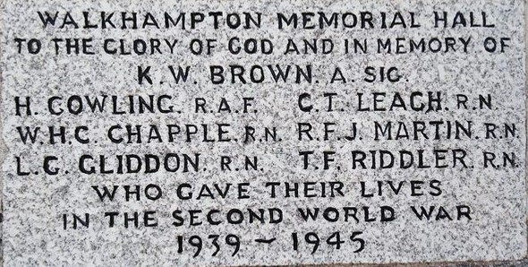
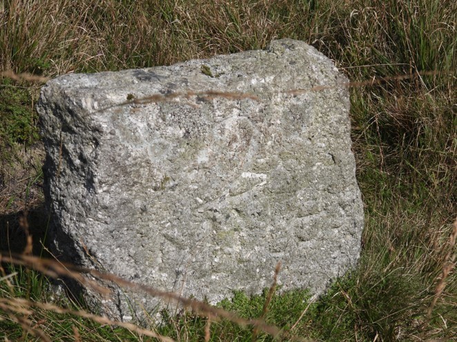
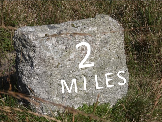
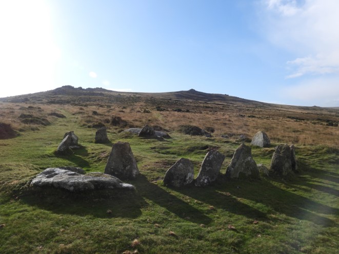
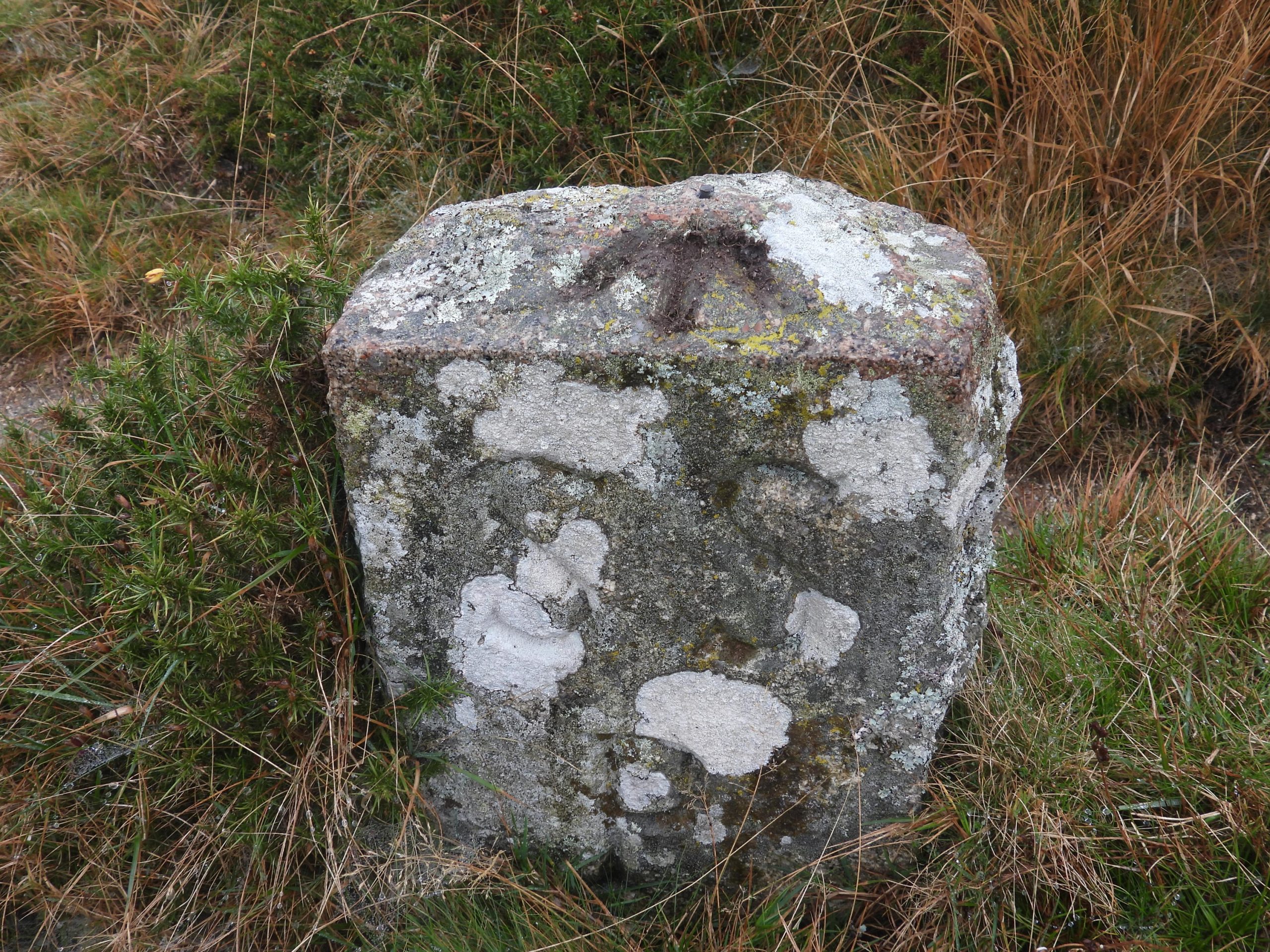
1st April – In Christow, April Fools day was known as ‘Tail-pipe Day’ because it was a custom to pin an inscription ‘Please kick me’ to the coat-tails of an unsuspecting victim. (Source: https://englisharound.blogspot.com/2010/04/aprils-fool.html?m=1). In Cornwall, an April Fool is a ‘guckaw’ or ‘gowk’, another word for cuckoo (a bird). If a child succeeded in ‘taking in’ another, he used to shout after him ~ “Fool, fool, the guckaw.” The pictures include the Parish church of St James the Apostle.1st April 1989: An agreement was made on this day between South West Water and the National Park Authority for the purpose of conserving and enhancing the natural beauty and amenity of the Burrator Reservoir catchment area (4120 acres, 1667 hectares). The agreement dealt with the promotion of the enjoyment of the area by the public and secured the proper use of the area for moorland grazing. The pictures were taken in 2020.1st April 1989: An agreement was made on this day between South West Water and the National Park Authority. The pictures collage are of photographs taken between March 2016 and July 2020.1st April 1910 : A former wayside cross recorded in Harford vestry minutes as “doing duty as a gate post in the Sanctuary Glebe-land”. The wayside cross in question was described also in the vestry minutes as “most interesting parochial event”. Source: Dartmoor 2001 – A Dartmoor diary of yesteryear by Mike Brown1st April 1910 : A former wayside cross recorded in Harford vestry minutes as “doing duty as a gate post in the Sanctuary Glebe-land”. The cross was later reported by local press as having been re-erected in the churchyard, where it still stands today.2nd April 1928: King’s Tor Halt opened. The picture is from the platform at King’s Tor Halt – looking NNE to King’s Tor. The old Foggintor Quarry line joining on the right was already disused by the 1950s.2nd April 1928: King’s Tor Halt opened. Leaving King’s Tor Halt and heading for Yelverton. This is looking NE across the old disused Foggintor Quarry line towards King’s Tor.2nd April 1928: King’s Tor Halt opened. This picture of the halt was taken on 3rd July 2020.3rd April 1948: E.G. Herman, who wrote under the name of John Trevena, died on this day. Trevena was described as an enigmatic Dartmoor writer and lived for a while in Belstone (photograph is Old Telephone Exchange / Zion Chapel in Belstone). 3rd April 1948: E.G. Herman, who wrote under the name of John Trevena, died on this day. His Dartmoor titles included: Furze the cruel, Heather and granite. The photograph is Belstone Green.4th April 1941: A Handley Page Hampden (AD748), crashed on Hangingstone Hill. The Hampden was often referred to by aircrews as the “Flying Suitcase” because of its cramped crew conditions. The aircraft was from 83 squadron and crashed whilst returning to RAF Scampton, in Lincolnshire after laying mines at La Rochelle, near Brest. Sadly all 4 crew members were killed. The crew were: L. R. Eden, L. R. Evans, A.M. Murray and E. D. Thompson (R.I.P.). The picture is from RAF Scampton with a Handley Page Hampden.4th April 1941: A Handley Page Hampden (AD748), crashed on Hangingstone Hill. The hill being so isolated near the head waters of the River Taw and East Dart must have made any potential rescue or recovery extremely difficult. The pictures are from 2012 through to 2019.5th April 1859: A complaint was made by the tenant of Lake Farm at Walkhampton over Plymouth and Dartmoor Railway Company fencing. In Mike Brown’s “Guide to Dartmoor” CD the story starts thus: “The course of the Plymouth & Dartmoor Railway winds through some of the fields in the vicinity. The PDR during its days when it was operated by the Johnsons was a constant source of frustration – as too were other aspects of the Johnsons’ activities, as well as their general behaviour and attitude, judging from the amount of paperwork which they created for successive manor stewards — as evinced by a letter which Coplestone L Radcliffe had to send to their agent on 5th April 1859 respecting another of the Lake farms.”5th April 1859: A complaint was made by the tenant of Lake Farm at Walkhampton over Plymouth and Dartmoor Railway Company fencing. In Mike Brown’s “Guide to Dartmoor” CD the story continues: “Mr Blatchford, the Tenant of one of the Farms called Lake in Walkhampton…complains (not without reason) that in Consequence of the Plymouth & Dartmoor Railway Company not properly keeping up their fences he is subject to Daily Trespass to a serious extent from the Cattle & Sheep of other parties. This morning his newly seeded ground was trespassed by some 30 to 50 sheep & the Consequence is that his Coming cut of hay is seriously affected at a time it could least bear it (the first shoot). He states that if any moderate amount of labour was bestowed on the fences this injury would not arise. Having called your attention therefore to this particular farm I shall be glad to learn from you that you will see to the proper…relief being afforded without delay.” The picture is where the line crosses Lake Lane.”5th April 1859: A complaint was made by the tenant of Lake Farm at Walkhampton over Plymouth and Dartmoor Railway company fencing. The picture is the land to the south of Lake Lane and shows part of the old Plymouth Leat. This location is assumed to be part of Lake farm and is just to the West of the farm.5th April 1889: The North East pinnacle of Walkhampton Church was struck by lightning which was sent crashing through the roof of the nave. The church of St. Mary the Virgin lies half-a-mile north of the village occupying a very ancient site. 5th April 1889: The North East pinnacle of Walkhampton Church was struck by lightning which was sent crashing through the roof of the nave. The church was built long before the village of Walkhampton hence the unusual distance. 5th April 1889: The North East pinnacle of Walkhampton Church was struck by lightning which was sent crashing through the roof of the nave. The west end of the nave was entirely demolished by this incident. However, a new pinnacle was commissioned soon after and the damage was soon made good. Into the 20th century, the tower was re-pointed and in 1965 and steel bracing added to strengthen the pinnacles.5th April 1889: The North East pinnacle of Walkhampton Church was struck by lightning which was sent crashing through the roof of the nave. An unusual feature of the church is that it faces north-east, not the normal due east. North east, of course, is the point of sunrise at the Summer Solstice. On this north east alignment is a old rock next to the road which is known locally as Gipsy Rock.5th April 1889: The North East pinnacle of Walkhampton Church was struck by lightning which was sent crashing through the roof of the nave. So why does the church align north east pointing towards Gipsy Rock ? The rock is said to have possibly been the meeting place of the ‘Walkhampton Hundred’ (administrative division) in Saxon times. Is this just pure coincidence? Source: A brief guide to St. Mary the Virgin, Walkhampton by Peter Hamilton-Leggett6th April 1986: Eric Hemery – A Tribute. Perhaps the most knowledgeable and well known of all the Dartmoor authors in the late 20th Century, Eric Hemery sadly passed away on this date. To the author of this post, he has been a huge inspiration and fabulous source of information, even in these days of the internet. Eric was born in Dorset and worked as a professional lecturer and guide on Dartmoor in the 1950’s. He was a very accomplished musician and was the Director of Music at Malvern girls college for a period. Eric moved to Clearbrook in later life to be nearer his beloved Dartmoor.6th April 1986: Eric Hemery – A Tribute. During the 1970’s, Eric started work on what some consider to be the best classic work of all time, namely, High Dartmoor: Land and People. With a forward by HRH Prince of Wales, Duke of Cornwall, the work is over 1000 pages of every possible detail on places, people, mysteries and much more that is a must for the library of any Dartmoor enthusiast. My favourite section of the work relates to photograph 411, which shows Eric atop the Hangingstone in 1954. He states that in 1964, he found the stone prostrate on the turf below the base rock. The Western Morning News reported that two years later (27th September 1966) that the stone (which was a rocking logan) had been replaced by the military. Sadly, on 26th October 1976, Eric reported that the stone didn’t rock and to everyone’s knowledge it hasn’t rocked again to this day. The colour photograph was taken in April 1991.6th April 1986: Eric Hemery – A Tribute. Eric’s other works included Historic Dart, Walking the Dartmoor Waterways, Walking the Dartmoor Railroads and Walking Dartmoor’s Ancient Tracks (which was posthumously published) . The author of this post has the latter three books in his collection. He also compiled the Bartholomew Guide – Walk Dartmoor (under the pseudonym Peter Tavy). A favourite section of the author from Walking the Dartmoor Railroads is Omen Beam Tramroad (P39 -46) with the desolate picture of the tramroad. The colour photograph is the end of the tramway, where there is a granite structure which is believed to be either the front of a loading platform or possibly the site of a press (Taylor 1848) at SX57510 77027 – May 2020.6th April 1986: Eric Hemery – A Tribute. A personal favourite of the author from Walking the Dartmoor Waterways is the section on Devon Wheal Friendship Leat (P46-51 and the picture of Wheal Jewell reservoir. The colour photograph was taken on a bright day in February 2020.6th April 1986: Eric Hemery – A Tribute. A personal favourite section of the author from Walking Dartmoor’s Ancient Tracks is North – South Track (P40 -59) especially as the cover photograph of the book shows two guide stones on the side of Cut Hill. The colour photograph was taken in November 2018 of one of the guide stones. As well as the three books remembered in this post, Eric was also responsible for writing ‘The West Country’ (Slidebooks, beautiful Britain series) and he contributed two chapters/walks to the Dartmoor National Park Guide- both were published in 1957.7th April 1906: The operation of last horse omnibus between Chagford and Moretonhampstead on this date. Visitors from the Victorian seaside resorts of Paignton, Dawlish and Torquay arriving at Moretonhampstead station found horse omnibuses waiting to take them on their explorations of Dartmoor between Moretonhampstead and Chagford.7th April 1906: The operation of last horse omnibus between Chagford and Moretonhampstead on this date. Moretonhampstead railway station had opened on 26th June 1866 but it wasn’t for another 40 years that the motorised omnibus was available and replaced the 4 legged powered mode of transport. The horse omnibus had operated prior to the railway arriving at Moretonhampstead.7th April 1906: The operation of last horse omnibus between Chagford and Moretonhampstead on this date. Outside the Globe Hotel.8th April 1893: William Widgery, the Dartmoor Artist died, aged 67. The picture is of a portrait by his son F.J. (Frederick John) Widgery of William Widgery circa 1887 (he would have been around 61 at that time).8th April 1893: William Widgery, the Dartmoor Artist died, aged 67. He was born in North Molton in 1826 and initially trained as a stonemason. When he moved to Exeter during his spare time he took-up painting. He was self-taught and often copied work by Landseer and Bonheur. Thomas Hext spotted Widgery’s paintings hanging in an inn and persuaded him to give up his job and take up painting as a career. The picture is a typical oil painting by Widgery accentuating the hills and tors of the moor.8th April 1893: William Widgery, the Dartmoor Artist died, aged 67. Widgery had a granite block cross erected to commemorate Queen Victoria’s Golden Jubilee in 1887. It is a well known land mark on Brat Tor, which is prominent from the Tavistock / Okehampton road.8th April 1893: William Widgery, the Dartmoor Artist died, aged 67. Widgery’s cross is made of 10 layers of roughly cut granite blocks, topped off with a pointed rock. The cross bears the inscription: ‘W. Widgery, Fecit, Jubilee, V.R.’8th April 1893: William Widgery, the Dartmoor Artist died, aged 67. In 1880, Widgery built a house and studio on the edge of Lydford where he lived for 10 years. This building is now The Lydford House Hotel. From the photographs, one suspects the property has been hugely extended since Widgery’s time there.9th April 1806: Isambard Kingdom Brunel was born. Although he will largely be remembered in the South West for his projects like the Royal Albert bridge and the Great Western Railway along the coast at Dawlish, he should also be remembered for other minor railway projects as the Great Western railway network expanded with branch lines during the 1850s. Photo by Robert Howlett.9th April 1806: Isambard Kingdom Brunel was born. The Walkham Valley Viaduct (now known as Gem Bridge), was designed by Brunel as part of the South Devon and Tavistock Railway. The bridge was constructed in the late 1850s. The picture is of the original Brunel-designed viaduct which was one of the longest in Devon. It had 16 spans of Baltic pine bridgework on masonry pillars and opened in 1859. It was the Tavistock South, then 7 foot broad gauge, rail route connecting Tavistock to Plymouth. (Source: https://www.saburchill.com/history/articles/003.html) 9th April 1806: Isambard Kingdom Brunel was born. The line was converted to standard gauge 4ft 8 inches in 1892 and around 1910 the original timber on the Walkham viaduct was replaced with a steel trestle , supported on the original masonry pillars which were extended upwards. The line closed in 1962 and the bridge was demolished in 1965.9th April 1806: Isambard Kingdom Brunel was born. Just over 200 years after Brunel was born and 150 years since the original Walkham Valley bridge was built, the new “Gem cycle bridge” was opened in 2012 for cyclists and walkers. Its design references Brunel’s original timber viaduct. I think Brunel would have approved.9th April 1806: Isambard Kingdom Brunel was born. The Walkham Valley Viaduct (now known as Gem Bridge), was designed by Brunel as part of the South Devon and Tavistock Railway and as this picture from circa 1887 shows had a mine (Gem Mine) at its base.10th April 1305: Chagford confirmed as a town for coinage of tin. King Edward 1’s 1305 Stannary Charter established Tavistock, Ashburton and Chagford as Devon’s stannary towns, with a monopoly on all tin mining in Devon, a right to representation in the Stannary Parliament and a right to the jurisdiction of the Stannary Courts. The picture is Chagford from Nattadon Tor. 10th April 1305: Chagford confirmed as a town for coinage of tin. Finally, Plympton became the fourth Devon stannary town in 1328 after a powerful lobby persuaded the Sherrif of Devon that it was nearer the sea and therefore had better access for merchants. The picture is zoomed in from Nattadon Down.11th April 1900: St. Raphael’s Chapel, Huccaby was licenced for marriages on this date. The property was originally acquired by the Duchy of Cornwall in 1868 under the Duchy of Cornwall Management Act 1863 and the School Sites Acts. Its purpose was originally intended as a school but was licenced for divine worship the same year. William Crossing stated the original old cottages on the site were thatched with rye straw. (Source: Dartmoor Magazine #132)11th April 1900: St. Raphael’s Chapel, Huccaby was licenced for marriages on this date. The Good Shepherd window, donated by the Adams family of Huccaby, in memory of Edward Adams, who died in 1888 aged only 11 years.11th April 1900: St. Raphael’s Chapel, Huccaby was licenced for marriages on this date. St Raphael’s was designed to act as both a place of worship and a school. The desks also being used as pews. The church is unique, insofar as it is the only Anglican Church in the country dedicated to St. Raphael, who is the patron saint of travellers and whose name means “God’s healing” or “God has healed”.11th April 2004: Cut Hill Stone Row was surveyed by Dr Tom Greeves on this date having noticing a ditched barrow the week before (on 4th April). The stones in the row are orientated WSW – ENE. Its recorded length is 125m. At 603m a.s.l , the discovery was 100m higher that the previous highest found (on Conies Down).11th April 2004: Cut Hill Stone Row was surveyed by Dr Tom Greeves on this date. The picture is stone 1 at WSW end.11th April 2004: Cut Hill Stone Row was surveyed by Dr Tom Greeves on this date. The picture is stone 3, the well known “JEW” stone. It is not known by whom or why this stone was inscribed.11th April 1992: The well respected author of Dartmoor books and articles, John Robins passed away on this date. He was just two weeks away from his 87th birthday. He had a long career with Cable and Wireless and was awarded a British Empire medal in 1947 for services to his fellow internees after being taken prisoner by the Japanese whilst he was stationed in Singapore. He retired in 1961 and was a member of both Devonshire and Dartmoor Preservation Associations. His book “Follow the Leat” (see picture) was published in 1982 (second edition in 1984). A further book, “Rambling on” followed in 1988. (Source: Dartmoor Magazine – Summer 1992 – Issue 27). R.I.P John.11th April 1992: The well respected author of Dartmoor books and articles, John Robins passed away on this date. John penned a novel in 1991, called “Classywell’s Secret”. It is based around farms in the Newleycombe Valley, the Eylesbarrow Tin Mine and other familiar landmarks on the moor. It is a historical tale of romance, passion and tragedy. The picture is Classeywell Farm taken in May 2020, with Down Tor and Sheepstor prominent in the background.12th April 1586: John Ford the English playwright and poet of the Jacobean and Caroline eras was baptised at Ilsington. It is assumed he was brought up on Dartmoor at Bagtor, Ilsington, because that is where he was baptised and that is where his father lived. He may have gone to the grammar school in Ashburton. 12th April 1586: John Ford the English playwright and poet of the Jacobean and Caroline eras was baptised at Ilsington. Some on-line sources state the baptism date was 17th April but Ancestry, FindmyPast and Familysearch.org, all give a transcribed date of 12th April. Using the fabulous DW research and archive services confirmed via the Devon Family History Society member’s page that it’s definitely 12th April. The date is written xij (the j is a 1). It is possible that someone has read it as X7 (ie 17). The picture is the statue of St. George on the lych gate at Ilsington.12th April 1586: John Ford the English playwright and poet of the Jacobean and Caroline eras was baptised at Ilsington. He was the second son of Thomas Ford of Ilsington; His mother was either the sister or niece of Lord Chief Justice Sir John Popham; His grandfather George Ford was very active in the Dartmoor tin-mining industry. It is believed that John Ford was matriculated as a member of Exeter College, Oxford, on 26th March 1601 and entered the Middle Temple in 1602, but there is no record of him being called to the bar. The picture is of the 1914 – 1918 War Memorial inside the lych gate at Ilsington12th April 1586: John Ford the English playwright and poet of the Jacobean and Caroline eras was baptised at Ilsington. The Coat of Arms are Ford of Bagtor and Nutwell. John Ford’s first appearance as an author was in 1606, aged 18, when he published Fame’s Memorial, a tribute to the memory of Charles Blunt, Earl of Devonshire. His first recorded play An Ill Beginning Has a Good End, was acted at the Cockpit in 1613 – the only known manuscript was destroyed in the 18th Century by John Warburton’s cook.12th April 1992: The annual O.A.T.S (Okehampton Adventure Training Scheme) walk between New Waste and Okehampton was held. The author completed the full 27.5 miles in 8 hours and 20 minutes. There is a story behind the walk is that the author was walking with a friend and both sets of our parents were walking the “half” O.A.T.S from Postbridge to Okehampton. We reached Postbridge (after 15 miles) and were two hours behind the “half” O.A.T.S walkers, so we decided to up our pace to catch them up ! By Oke Tor, we couldn’t see them, so we ran the final few miles into Okehampton. For the record, we didn’t catch them up but were only 10 minutes behind having made up 1 hour and 50 minutes. I don’t think I could walk let alone run that distance now……13th April 1839: Francis Chapple was paid £40 for building 70 Yards of Stone faced Hedge round an enclosure at Gee’s Cross on Ringmoor Down, as recorded in the manor stewards’ accounts of that year. In Mike Brown’s Dartmoor Guide to Dartmoor CD the story is told thus: “At or near this junction once stood Gees Cross, opposite what in the early-mid nineteenth was known as Gees Cross Cottage, presently named Ringmoor Down Cot. An alternative name for the cross was Smalacumbacrosse, a name once thought to have referred to Marchant’s Cross. The original twin cottages were built in 1827 by John Giles and John Folland, carpenter and mason, at a cost of £126, one William Squire then becoming the first new tenant in one of them, paying his first six months rent of £1 11s 6d on 6th June of that year, for what was described in the accounts entry as a ‘new House on Ringmore Down near Gee’s Cross’. At first the buildings only had little gardens attached, and the small copse of trees alongside was not enclosed and planted until 1839.” The map above is the 1840 tithe. The location is now known as Ringmoor cottage and the name Gees Cross doesn’t exist on modern OS maps.13th April 1839: Francis Chapple was paid £40 for building 70 Yards of Stone faced Hedge round an enclosure at Gee’s Cross on Ringmoor Down. It is interesting that there might have been a cross located here called Smalacumbacrosse (or Gee’s Cross). This considered by Richard Hansford Worth in 1942 in the Transactions of Devonshire Association, vol 74 (p203 – Marchants Cross, Meavy) he states: “One is tempted to identify this as the Smalacumba Cross which was one of the bounds of the lands given by Amicia, Countess of Devon, to the Abbey of Buckland. But, although the stream which flows from Ringmoor Cot past Yeo Farm to the Meavy is Smallcombe Lake, and there is a Smallcombe Wood in the valley, it would appear that, assuming the present parish boundary to represent the bounds of the land originally granted, Smalacumba Cross must have stood near Ringmoor Cot, at the head of the Smalacumba Lake.” This is also mentioned in Worth’s Dartmoor (P395).13th April 2000: An exhibition entitled ‘Dartmoor Century’ was opened at the High Moorland Centre in Princetown. The exhibition featured late-Victorian photographs. Two days later the exhibition was officially opened to the public, when a book of the same name (see photograph) produced by the Dartmoor Trust was also released13th April 2000: An exhibition entitled ‘Dartmoor Century’ was opened at the High Moorland Centre in Princetown. Many of the photographs were taken by Robert Burnard. This Burnard photograph was captioned as Headland Warren Row (also known as Challacombe Stone Row) and was taken in August 1893. The group (left to right) were rev. S. Baring-Gould, rev. Gordon Gray, Dr Prowse and Mr Wilder13th April 2000: An exhibition entitled ‘Dartmoor Century’ was opened at the High Moorland Centre in Princetown. Many of the photographs were taken by Robert Burnard. This is a 2020 recreation of the Robert Burnard original. The photographer is Frank Collinson. The author is in the composition13th April 2000: An exhibition entitled ‘Dartmoor Century’ was opened at the High Moorland Centre in Princetown. Many of the photographs were taken by Robert Burnard. The photograph of Norsworthy longhouse was taken in October 1894. Note the height of the trees and the looking rocky pinnacle of Leather Tor in the background. The well dressed figure by the gate could be Thomas Creber who was the tenant around that time.13th April 2000: An exhibition entitled ‘Dartmoor Century’ was opened at the High Moorland Centre in Princetown. Many of the photographs were taken by Robert Burnard. The same view as the 1894 picture, 129 years later. The rocky pinnacle of Leather Tor is harder to see, even though this picture was taken late Winter / early Spring with the trees still bare.13th April 2000: An exhibition entitled ‘Dartmoor Century’ was opened at the High Moorland Centre in Princetown. This cartoon appears in the Dartmoor Century Book and is from a Plymouth Newspaper of 15th June 1914 poking fun at the establishment of a letterbox at Cranmere Pool13th April 2000: An exhibition entitled ‘Dartmoor Century’ was opened at the High Moorland Centre in Princetown. Cranmere Pool was visited by Robert Burnard on 12th August 1889 and he was accompanied by F.L. Burnard, L.F. Burnard, Olive L. Burnard, Charlie F. Burnard, Dorothy Burnard, Mrs Slack, Tom Eastering, Joe Reynolds, Frank Reynolds, Harold Williams, E. Bridgeman, J. Bridgeman and Charlie French. They took a horse and cart and five saddle horses as far as Mute’s Inn (between Quinitin’s Man and Whitehorse Hill summit). They deposited all their names in the cairn at the pool13th April 2000: An exhibition entitled ‘Dartmoor Century’ was opened at the High Moorland Centre in Princetown. Cranmere Pool in April 2025. The stone cairn is to be moved due to the peat restoration project and a temporary wooden structure has been place on the peat bank above.13th April 2000: An exhibition entitled ‘Dartmoor Century’ was opened at the High Moorland Centre in Princetown. Robert Burnard by Lower Cherry Brook Bridge in December 1887. Note the line of granite posts marking the edge of the unmetalled track just before the bridge13th April 2000: An exhibition entitled ‘Dartmoor Century’ was opened at the High Moorland Centre in Princetown. Lower Cherry Brook Bridge in May 202113th April 2000: An exhibition entitled ‘Dartmoor Century’ was opened at the High Moorland Centre in Princetown. Robert Burnard transported from 19th century into the 21st century14th April 1894: Dartmoor Exploration Committee re-erected stones at Hingston Hill Stone Row. Although not named on the original photograph, it is likely that George French is one of the workmen with the clergyman being the Rev. W.A.S. Gray. In the 3rd volume of his Dartmoor Atlas of Antiquities Jeremy Butler states: “The spectacular row on Hingston Hill probably looks much as it did when the stones were first erected in Bronze Age times. Much of its present appearance though is due to Burnard and his associates who re-erected many of them in 1894. The majority were then lying flat, ‘thrown down’ about 1880 according to Baring Gould by ‘men recently engaged on the row with crowbars’. The huge pillar [seen in Burnard’s photograph] next to the cairn weighing about 3 tons had collapsed across its neighbour to the east. The sockets of the western three were excavated and deepened and the stones secured with ‘a little Portland cement’ around their bases”.14th April 1894: Dartmoor Exploration Committee re-erected stones at Hingston Hill Stone Row. The picture was taken at sunrise on 21st June 2014 (summer solstice), note the shadows from one stone aligns with the next. Is this (the shadow alignment) a coincidence that it’s the Summer Solstice ?14th April 1894: Dartmoor Exploration Committee re-erected stones at Hingston Hill Stone Row. The picture was taken at sunrise on 21st June 2014 (summer solstice), note the shadow from largest stone (and closest to the circle) entirely crosses the centre of the circle.14th April 2002: On this day, Dr Tom Greeves reported his discovery of an inscription in the outside, north wall of Chapel of La Wallen. He reported two sets of inscribed initials (IB and IV) towards the top left of the boulder with two crosses to the right of them. Towards the bottom right of the boulder is the initials DS. Although still discernible, these inscriptions aren’t very photogenic unless caught in the right light (hence the two sets of photographs). Dr Greeves, stated that in the book Gidleigh – A Dartmoor village past and present, both Chapple Farm and Moortown Farm (on which the chapel is located) had links with the Brock and Vogel families over many centuries. The conjecture is that the initials “IB and IV” relate to these two families – possibly a betrothal. The inscribed boulder can be found at SX66928 88943.14th April 2002: On this day, Dr Tom Greeves reported his discovery of an inscription in the outside, north wall of Chapel of La Wallen. According to Historic England website: “The Rev. J Rawson argues convincingly that this small building is the remains of the chapel of La Wallen, dedicated to the Blessed Virgin Mary. It was desecrated in 1332 when the clerk Robert de Middlecotte committed a murder there. The alignment, construction and disposition of the windows certainly look like a small chapel and it is probably no accident that the nearby farmhouse is called Chapple”.14th April 2002: On this day, Dr Tom Greeves reported his discovery of an inscription in the outside, north wall of Chapel of La Wallen. According to Historic England website further states: “Probably in the C16 or C17 the west end was demolished and the building shortened and it was converted to a (cow) byre. It contains a small rectangular window in the east end, another towards the east end of the north wall and a third is assumed opposite in the south wall but a doorway has since been knocked through here. The original entrance is thought to have been in the west end but this has been demolished and a new west wall built”. 14th April 1857: On this day, the renowned antiquarian G. W. Ormerod reported seeing a shaft used as a gatepost in a field near Watching Place Cross, North Bovey. The shaft was later rescued and erected in its current position at SX71302 84203. The cross is 1.40 metres tall and 0.40 metres across the arms.14th April 1857: On this day, the renowned antiquarian G. W. Ormerod* reported seeing a shaft used as a gatepost in a field near Watching Place Cross, North Bovey. It has become known as Beetor Cross. *George Wareing Ormerod (1810-1891) was a Chagford solicitor who was also a keen geologist as well as an antiquarian15th April 1920: Robert Burnard the eminent Dartmoor writer / photographer, died on this date. He established the Dartmoor Preservation Association (DPA) in 1883. In 1887 he published his first paper on Dartmoor’s antiquities. He was the grandfather of (Lady) Sylvia Sayer, who continued the DPA work at the latter end of the 20th Century. By all accounts, Robert Burnard was very thorough but at the same time quite conscious that the existing archaeological knowledge of Dartmoor was somewhat superficial. He decided to systematically excavate some prehistoric hut circles under a group called the Devonshire Association’s Dartmoor Exploration Committee. 15th April 1920: Robert Burnard the eminent Dartmoor writer / photographer, died on this date. The author, in 2020, to recognise the 100th year of Robert Burnard’s passing recreated one of his photographs. The photograph was from around 1893 from his wonderful pictorial collection and taken at Challacombe stone row (captioned as Headland Warren stone row on the photograph). The author had a change of hats for the recreation !16th April 1876: F. H. Firth of Cator went to Corndon Tor to see the “Sun Dance”. This was an old Dartmoor tradition of waking up early, going to a high point to see the sunrise on Easter morning. The tradition was based on the belief that on this day the sun as it rose into the moorland sky actually danced for joy. The reason being that it was celebrating the resurrection of Jesus Christ. (Source of text: Legendary Dartmoor website). The story of F.H. Firth was recorded in the issue of the Transactions of the Devonshire Association, TDA 1900, pp. 85 -8616th April 1876: F. H. Firth of Cator went to Corndon Tor to see the “Sun Dance”. According to the story, Mr. Firth was taken to to see the ‘sun dance’ by “Old John”. Mr Firth and his sons followed Old John the three miles up to Corndon Tor, from Cator. On reaching the summit Firth is said to have remarked that; “a scene of unparalleled splendour broke upon their view, through a cloudless sky and rare atmosphere.” According to Old John the sun would carry on performing it’s dance until around 10.00am although less vigorously. (Source of text: Legendary Dartmoor website).17th April 1959: “Television comes to Postbridge” was the title in a published letter in Farmers Weekly published on this date. The letter described the BBC TV interview of Jack Bellamy (the Postbridge pony riding postman) and was penned by his daughter-in-law. The picture above and the letter appear in the book “Postbridge – The heart of the moor” written by Reg Bellamy (the husband of the letter writer).17th April 1959: “Television comes to Postbridge” was the title in a published letter in Farmers Weekly published on this date. Jack Bellamy was a well known pony riding postman from the late 50’s / early 60’s and had three ponies he would use: Smokey, Tinker or Tosca. The round was 10 miles and was done, 6 days a week. Eventually the rounds were taken over by Yelverton and covered by vans, when the post was no longer sorted at Postbridge.
This You Tube video is circa 1957 and shows John Bellamy on Tinker, doing his round. One assumes John was known as Jack to his family.17th April 1959: “Television comes to Postbridge” was the title in a published letter in Farmers Weekly published on this date. Pictures of Postbridge from 16th April 2021, some 62 years almost to the day after the article was published.18th April 1861: The Butterdon Rifle Range. On this date, it was reported that there were “500 troops ready to encamp within a few days at the rifle range”. (Source: An article by Dave Brewer in the Dartmoor Magazine from Winter 1996 provides an excellent summary of the Butter Brook rifle range which was only used for a short period, from April to July 1861.) The drawing above is based on the original Dave Brewer drawing in the DM but has been amended to show the approx. location of all the 102 markers. This is not to scale. Apparently, the military were only given landowner permission for a range within Ugborough Parish.18th April 1861: The Butterdon Rifle Range. The range comprised 4 alleys with 4 sets of butts with 4 Observation Posts. Each of these 4 alleys had two “lanes” with range markers up to 900 yds away at 50 yd intervals. The GPS plot above is from the author when he explored the area in 2020. It shows the lanes were parallel to each other and not in a “fan” shape as suggested by the previous drawing. The range markers are made from rough moor stone and each is approx 20cm (8in) x 12.5cm (5in). With a bit of patience all 102 markers can be located. 18th April 1861: The Butterdon Rifle Range. The above picture is alley “A” Butt. This Butt was used by the 2nd & 12th regiments.18th April 1861: The Butterdon Rifle Range. The above picture is alley “A” Observation Post. This Observation Post was used by the 2nd & 12th regiments.18th April 1861: The Butterdon Rifle Range. The above picture is of the range markers for Alley A (2). There are 16 markers from 150 yards through 900 yards but the 100 yard marker is missing. Note that the 900 marker is inscribed ‘009’.18th April 1861: The Butterdon Rifle Range. Interestingly, around the 700 to 800 yard mark on Alley A, you can’t see the butts. However, the are several raised platforms, like the one shown in the picture above. Was this used to elevate the rifleman, so he could see the butts ?19th April 1915: Foggintor school opened. The purpose built school, Foggintor School, provided education for the children from Foggintor and the surrounding area between 1915 and 1936. The school was on land donated by Sir Henry Lopes. When the school opened it had 55 children.19th April 1915: Foggintor school opened. The site is now a car park known locally as Four Winds, after the renamed school house which was a private home until the early 1960’s. It is located next to the Two Bridges – Tavistock Road. The school was demolished in 1964 and the house in 1965. Some of the stone was used for the road straightening at Devils Bridge.19th April 1915: Foggintor school opened. The caption for the black and white photograph reads: ‘The headmaster, Mr Stoyle, his wife and their son Ivan pose for the photographer at the rear of the Headmaster’s House’. 19th April 1915: Foggintor school opened. Prior to 1915, the education of the children was provided at the Dartmoor Mission Hall (1896 – 1913) and at the small Wesleyan Chapel at Foggintor Quarry (from mid 19th Century to 1896, then briefly from 1913 – 1915). 20th April 1989: F.H (Harry) Starkey passed away on this date. He was 76 and was a well loved Dartmoor enthusiast, author and speaker. He wrote 5 books: Exploring Dartmoor (1980), Exploring Dartmoor Again (1981), Dartmoor Crosses and some Ancient Tracks (1983), Odds and Ends from Dartmoor (1984) and Dartmoor, Then and Now (1986). The author has three of his works and pre-internet days were a much thumbed source of information. He wrote regular articles for the Dartmoor Magazine including many walks under the pen-name of ‘Nobbut’ (based on a term he often used when he was a policeman answering questions “no but”). Harry Starkey was born in London but moved to Yorkshire then Lincolnshire. He then served in the Metropolitan Police Force for 31 years, where he reached the rank of Chief Superintendent. When he retired he moved to Haytor Vale, where he lived for 23 years. His last few years were spent in Liverton. 20th April 1989: F.H (Harry) Starkey passed away on this date. He was a committee member of the Dartmoor Preservation Association and the Devonshire Association. He also belonged to the Devon Archaeological Society, the Ramblers Association and the Bovey Tracey Probus Club. He gave many illustrated talk to the Workers Educational Association (WEA) and an initiative was taken by the Teignmouth WEA in early 1990 to obtain permission from the DNPA to restore the Manga clapper (near Teignhead Farm), as historically it was Harry who had discovered it in a dilapidated state. The clapper (photograph above) was restored in his memory and is known to some as “Starkey’s Clapper”.20th April 1989: F.H (Harry) Starkey passed away on this date. Next to the restored Manga clapper (“Starkey’s Clapper”) is a small boulder with a small cross with ‘F H S 1912 -1989’ incised on it. On 1st April 1990 there was a memorial walk organised to visit the newly restored clapper bridge and the incised boulder. (Source: Legendary Dartmoor).20th April 1989: F.H (Harry) Starkey passed away on this date. The memorial walk to the new clapper (see picture of it being put into place), was led by Jane Machand and Grace Landon. Source: Dartmoor Magazine.20th April 1989: F.H (Harry) Starkey passed away on this date. The photographs show the “Duke Stone”, which can be found in a marshy area at SX74523 77192. The stone is a boundary marker for the Ilsington / Manaton parish. In 1853 it was agreed to erect this stone “to the memory of the present Lord of the Manor” (Edward Adolphus, the Duke of Somerset). However, the original stone is believed to have gone missing in 1938. This stone is the 1993 version erected by Dartmoor Preservation Association, in memory of F.H (Harry) Starkey. It was erected on 11th May 1993 and has the initials FHS near the base on the side which is also inscribed DS 1853.20th April 1847: John Chudleigh was born. He was an amateur archaeologist known to his family as “Dartmoor Chudleigh”. He is probably best known for being the author of the illustrated book “Devonshire Antiquities”. John was an architect, builder and surveyor and lived in Newton Abbot. The pictures show the front cover and inside page of the 1893 second edition of the Devonshire Antiquities book.20th April 1847: John Chudleigh was born. In his illustrated book “Devonshire Antiquities”, there are some fabulous “plates”. Walk XV11 (Moreton to Grey Wethers, Sittaford Tor, Kestor and Chagford) includes an illustration of Grey Wethers. The colour photograph was taken just 4 days before his 174th birthday!21st April 1938: Walkhampton Village – It is recorded in the Walkhampton Parish meetings that, even a year before hostilities had begun, Vice Admiral Peck gave a talk on air raid precautions. (Source: Mike Brown Guide to Dartmoor CD). The “then and now” comparison pictures were supplied by Nigel Machin, who commented: “Walkhampton 1900 vs 2020. Little seems to have changed in 120 years. The war memorial was obviously erected about 20 years after the first photo. The chances are that several of the young lads in the picture fought in the Great War and sadly some of their names may be on the memorial. C.G. Neal’s the grocer’s shop on the left was a shop until early this century but is now a private house.”21st April 1938: Walkhampton Village – It is recorded in the Walkhampton Parish meetings that, even a year before hostilities had begun, Vice Admiral Peck gave a talk on air raid precautions. The pictures are from April 2021, showing the War Memorial, Walkhampton Inn, the old school house and the fabulous bus shelter.21st April 1938: Walkhampton Village – It is recorded in the Walkhampton Parish meetings that, even a year before hostilities had begun, Vice Admiral Peck gave a talk on air raid precautions. The pictures are from April 2021, showing a black and white image of the Black Brook with road sign from the 60s (guessing from the two cars), bucks bench (1987), the old post office and the clock tower of Lady Modifords Church of England Primary School. 21st April 1938: A new Sunday school room opened at Dunstone Methodist Chapel. The picture is of Dunstone Chapel with views to the east. 21st April 1938: A new Sunday school room opened at Dunstone Methodist Chapel. The Wesleyan Chapel is now known simply as Dunstone Chapel. The chapel is made from rubble and slate and the entrance at the east end has an arched gallery window over.21st April 1938: A new Sunday school room opened at Dunstone Methodist Chapel. The (Wesleyan) Chapel is depicted on the 1840s Tithe Map, having been opened in 1833.22nd April 1864: Lease date of Wheal Frederick which sometimes is erroneously referred to as Foxholes Mine. The sett covered a huge area and was defined as: “First within or under the lands forming a portion of the Common of Devon bounded in the West by a straight line drawn through the centre of Doe Tor and Arms Tor so as to intersect the River Lyd on the North West by the said River Lyd on the North by a straight line drawn due West from the Rattlebrook Head on the East by the Rattlebrook aforesaid and on the South by the line of the Forest Drift between Dead Lake Foot and Doe Tor Brook. Secondly wherein or under the lands part whereof form a portion of the Common of Devon and the remaining part whereof are situate within the Manor of Lydford and Forest of Dartmoor bounded in the West in part thereof by the Rattlebrook aforesaid and for the remaining part by a straight line drawn from the head of the said Brook to the most Southerly corner of the enclosure about three furlongs North West from Shelstone Tor on the North by a stream flowing on the North side of Shelstone Tor into the West Okement River on the East in part by the West Okement River from the point where it is joined by the said stream to another point about four hundred fathoms South by West from Lints Tor and for the remaining part by the two streams on the East side of Anncombe Hill and by a straight line drawn between their heads and on the South by the River Tavy.” The picture is Dick’s Reservoir (a tinners construction), with Great Links Tor in the background.22nd April 1864: Lease date of Wheal Frederick. The picture is just below Dick’s Reservoir on Doe Tor brook at the head of tinners workings. 22nd April 1864: Lease date of Wheal Frederick. The picture is of a possible tinners cache, which can be found at SX 54867 85862.22nd April 1864: Lease date of Wheal Frederick. The picture is of an old clapper over a dry leat a few hundred metres upstream from the main Wheal Frederick building. This can be found as SX54611 85540.22nd April 1864: Lease date of Wheal Frederick. The picture is of an old clapper a few hundred metres upstream from the main Wheal Frederick building. This can be found as SX54623 85469. Wheal Frederick is sometimes erroneously referred to as Foxholes Mine, Foxholes is in fact the large crescentic area of streamworks on the opposite bank of the brook where there are a number of blocked adits in the low scarp surrounding the area, the most obvious of them in the bank immediately under Sharp Tor. Both Hare Tor and Sharp Tor can be seen in the background of the picture.22nd April 1823: An entry in the Maristow Stewards’ Accounts suggested that maybe Ailsborough Mine was issuing their own bank notes. The entry states : “Seven one pound Ailsborough Blowing House Notes sent to you [Sir Ralph Lopes] at London: £7” (reference: Dartmoor 2001, a Dartmoor Diary of Yesteryear by Mike Brown). The picture is a facsimile of one of the notes given to the author by Dartmoor Chris. 22nd April 1823: An entry in the Maristow Stewards’ Accounts suggested that maybe Ailsborough Mine was issuing their own bank notes. The picture collage relates to Ralph Lopes and Ailsborough Mine as follows: Top left: Procession engraving of the Chairing of Sir Ralph Lopes, Baronet, the Newly-Elected MP for South Devon (albeit it dates 26 years after the bank note in 1849), Top Middle: Arms of Lopes (granted to Ralph Lopes’ uncle Manasseh Lopes, blazoned Azure, a chevron or charged with three bars gemelles gules between three eagles rising of the second on a chief of the second five lozenges of the first, Right: Plan of Ailsborough (Eylesbarrow) Mine, Bottom Left: depiction of a Blowing House from DTRG.22nd April 1823: An entry in the Maristow Stewards’ Accounts suggested that maybe Ailsborough Mine was issuing their own bank notes. Picture is a general view of the Ailsborough Blowing Mill. The smelting house consists of a rectangular building with internal dimensions of 17.9m by 6.1m, split into a Reverberatory Furnace end (to the east) and a Blast Furnace end (to the west).23rd April 1613: First known lease for Vag Hill warren was drawn up. The warren at Vag Hill lies on its southern slopes comprises twenty five pillow mounds and three vermin traps. Also on the slopes, there is the outline of a warren house (near Vag Hill Tor) overlooking the Dart valley. The house is known as “Warren Pit”. The warren is mentioned both by RG Haynes, a well known authority on warrens from circa 1970, Jeremy Butler in his Atlas of Antiquities and online in the Pastscape record. Vag Hill is not named on modern OS maps.23rd April 1613: First known lease for Vag Hill warren was drawn up. R.G Haynes in his paper titled ‘Vermin Traps and Rabbit Warrens on Dartmoor’ states: “The warren of about 520 acres had its boundaries recorded in a lease of 1613; these were defined as waste ground lying between the river Dart on the west and southeast, and from thence to Yartor on the north and from Yartor to Corndon Tor on the north and east to the west of the Rowbrook hedge and so on to Logator on the east and so on to the river Dart.” The picture is of a Pillow mound with three trees, which can be found at SX67870 72575.23rd April 1613: First known lease for Vag Hill warren was drawn up. Dave Brewer in his book Dartmoor Boundary Markers (2001 version), states: “The earliest documentary evidence of the warren was a lease which was drawn up on the 23rd of April 1613 between William, Earl of Bath and the two warreners, Richard Meynell and Walter Fursland of Bickington. In this document the bounds were clearly stated: “... concerning waste ground called Spitchwick Common lying between the river Darte (Dart) on the west and south east and from thence to Heartor (Yar Tor) to Cornetor (Corndon) on the north and east to the west of Rowbrook Hedge and so to Logator (Luckey Tor) on the east and so to the river of Darte with free liberty to make a warren there for the keeping and breeding and killing of rabbits. And also if any rabbits go over the Darte to the common there called Holne Common alias Holne Cleyves between Comson hedge and Whortaparke corner or to any place in the said Common of Spitchwicke the said Richard and Walter may kill them. Rent 10/- (shillings)”. The picture is a Vermin trap from the warren. It is a very faint overgrown V shape to the right of the wall. SX68078 72669. It is also shown in Butler Atlas of Dartmoor Antiquities, RG Haynes booklet and Pastscape.org.uk.23rd April 1613: First known lease for Vag Hill warren was drawn up. The picture shows Vag Hill Warren House (aka Warren Pit). Vag Hill Tor can be seen on the hillside, mid distance.24th April 1591: The Water supply to Plymouth via the Plymouth (Drake’s) Leat was inaugurated. This was in the presence of Sir Francis Drake at the leat’s headweir. In the 16th century the need to victual the growing number of ships in Plymouth increased and accordingly so did its population. The waters of the Plym and Tavy were polluted so an alternative was sought. The corporation of Plymouth, in 1559 paid 26s and 10d to a Mr Forsland of Bovey Tracy to carry out a survey “viewinge of the ground wherebie freshe water myght have byn brought to the town”. (Source: Burrator, a pictorial history by Peter Walsh and Brian Byng). For some reason this survey never took place until 1576 when Robert Lampen lead a team of surveyors in search of a route for a leat. The picture is from an engraving from Elizabethan times of the the course of the leat.24th April 1591: The Water supply to Plymouth via the Plymouth (Drake’s) Leat was inaugurated. River Meavy and it’s watershed was chosen to provide the water source and subsequently a water act was submitted to Parliament in 1584. The act received Royal Assent on the 29th of March 1584. The act gave permission to: “the diggeing and myneing of a cliche or trenche contayninge in breadthe betwene sixe or seaven foote over in all places throughe and over all the lands and grounds lyeing betwene the said towne of Plymowth and anye part of the said ryver of Mewe als saide Meyve and to digge, myne and breake, baulk, cast upp all and al mener of rockes, stones, gravel and sandes and all other lets in anye place or groundes for the conveyance or necessarie conveyenge of the same ryver to the said towne…“ (Source: Burrator, a pictorial history by Peter Walsh and Brian Byng). Five years was to pass before any “diggeing” took place !! The map shows the location of the headweir in the late 19th century.24th April 1591: The Water supply to Plymouth via the Plymouth (Drake’s) Leat was inaugurated. The “diggeing” of the leat started in December 1590 and was completed in April 1591 at a rate of over 1 mile per week ! The above picture and google map image shows the approx location of the 18th century headweir.24th April 1591: The Water supply to Plymouth via the Plymouth (Drake’s) Leat was inaugurated. The main contractor for “diggeing” was Sir Francis Drake. The leat ran from River Meavy to Sutton Pool and was officially opened on the 24th of April 1591. The project cost Drake £300, which included building costs and compensation to local landowners. A team of local tin miners was used to cut the leat because of their undoubted engineering skills in leat building. It was said that on the opening day Sir Francis Drake, mounted on his white horse, rode escort to the waters as they flowed down the new leat to Plymouth. This leat became known as ‘Drakes Leat’ and provided water to the Plymouth area for over 300 years. (Source: Legendary Dartmoor website). Sometime later it was decided to celebrate the fact by holding an annual ‘Fyshinge Feaste’. The actual ceremony consisted of the Mayor of Plymouth and his council going to the head weir of the leat where official toasts would be given. The picture is of the mayors annual survey (Fyshinge Feaste) taken from the illustrated London News of 30th June 1856.24th April 1591: The Water supply to Plymouth via the Plymouth (Drake’s) Leat was inaugurated. The picture is of “The Fyshinge Feaste” on the Head Weir variously reported as taken either in 1890 or at the last one in 1898 (before Burrator reservoir flooded the location).24th April 1882: A precise definition was made of the point at which the Forest of Dartmoor meets Throwleigh and South Tawton parish boundaries and is endorsed to be the Whitmoor Stone. (Source: The Dartmoor Diary 1991 by DNP).25th April 1643: English Civil War – The Battle of Sourton Down. On the night of the 25th April 1643, the Battle of Sourton Down was a successful Parliamentarian ambush at Sourton Down. A description of the battle can be found in Okehampton’s Museum of Dartmoor Life and ends: ‘By dawn the Royalists had withdrawn to Bridestowe and the Parliamentarians to Okehampton. The field was held by Chudleigh and 12 of his horse. save for sixty Royalists dead, Sourton Down was deserted. In the local church register, there is no mention of those killed, so they were probably buried on the field of action. Such a severe blow to the Royalists was a major coup for the parliamentary cause. The London pamphleteers could not find sufficient words to praise the Devonian value and resolution.’ The picture shows Royalists (Blue) and Parliamentarians (Red).25th April 1643: English Civil War – The Battle of Sourton Down. The picture is taken from the Kings Way looking North toward the battle site. The two granite posts (The Iron Gates), mark the King Way ancient track. They are described in Crossing’s Guide to Dartmoor, viz: “This was a fast, moorland track used by the King’s messengers, avoiding the rutted roads. Used widely in the 1700’s. In 1630, there was a petition to Charles I to provide horses on the western stages of His Majesty’s Post, the normal roads were muddy, twisty, enclosed and slow”.26th April 2003: Day one of the 12th Dartmoor Challenge in aid of CLIC (Cancer and Leukaemia in Childhood) took place on this date. It was a two day event covering 32 miles. A report on the event appeared in Dartmoor Magazine issue 74. Day one route was: Plume of Feathers, Princetown; Whiteworks; Swincombe; Hexworthy; Dartmeet; Babeny; Cator Green and Warren House Inn.26th April 2003: Day one of the 12th Dartmoor Challenge in aid of CLIC (Cancer and Leukaemia in Childhood) took place on this date. The pictures show some of the locations of the first day (which finished at Warren House Inn). Day two route was: Plume of Feathers, Princetown; Nuns Cross; Eylesbarrow; Higher Hartor; Lower Hartor; Drizzlecombe; Ditsworthy Warren House; Norsworthy Bridge; Stanlake; Swell Tor and the railway line back to Princetown.26th April 1994: Enclosed stone hut circle settlement, east of Doe Tor, was registered on Historic England website, reference 1007663. This monument isn’t shown on the latest OS maps and can easily be missed when walking between between Doe Tor and Sharp Tor.26th April 1994: Enclosed stone hut circle settlement, east of Doe Tor, was registered on Historic England website. It is described on the website thus: “The monument includes 12 stone hut circles sitting within an enclosure situated on the lower west-facing slope of Sharp Tor overlooking Doe Tor. The interior of the enclosure measures 105m east to west by 75m north to south and is defined by a 1m wide and 0.6m high orthostatic wall faced by slabs on both sides and infilled with rubble. The stone hut circles are composed of stone and earth banks each surrounding an internal area”. As you approach the enclosure wall on the west side the monument does become more apparent, albeit being quite overgrown. 26th April 1994: Enclosed stone hut circle settlement, east of Doe Tor, was registered on Historic England website. It is further described on the website thus: “Of the huts, 11 are circular in plan and one is D-shaped. The internal diameter of the circular huts varies between 3.5m and 5.3m with the average being 4.8m. The D-shaped hut measures 4m long by 3.6m wide and is attached to the enclosure wall. The height of all the surrounding walls varies between 0.4m and 0.9m with the average being 0.72m. One hut is attached to the enclosure boundary and one has a visible doorway”. As can be seen from the pictures, many of the huts are discernible (but you do need to be quite close to them)26th April 1689: At the Buckland-in-the-Moor manor court the occupiers of Elletts Hill (now Elliots Farm) and Bohaydown (now Bowden) were ordered to repair the Liddygate (now Ripman’s Gate). Source: Dartmoor 2001, a Dartmoor Diary of Yesteryear by Mike Brown. The collage pictures are of Elliotts Farm, which is said to date from at least the 18th century. It was greatly extended in the mid-19th century.26th April 1689: At the Buckland-in-the-Moor manor court the occupiers of Elletts Hill (now Elliots Farm) and Bohaydown (now Bowden) were ordered to repair the Liddygate (now Ripman’s Gate). The granite rollers are located near Elliots Farm.26th April 1689: At the Buckland-in-the-Moor manor court the occupiers of Elletts Hill (now Elliots Farm) and Bohaydown (now Bowden) were ordered to repair the Liddygate (now Ripman’s Gate). Bowden was first documented at ‘Boghedoune’ in 1330. It was owned by the Woolcotts (late 16th century) and the Jennynge’s (early 17th century) before being sold to Buckland Manor in 1639 for £200.26th April 1689: At the Buckland-in-the-Moor manor court the occupiers of Elletts Hill (now Elliots Farm) and Bohaydown (now Bowden) were ordered to repair the Liddygate (now Ripman’s Gate). The picture is Bowden Lane between Bowden and Ripman’s Gate. The lane crosses over Ruddycleave Water and is bounded by Birch Wood on its south side.26th April 1689: At the Buckland-in-the-Moor manor court the occupiers of Elletts Hill (now Elliots Farm) and Bohaydown (now Bowden) were ordered to repair the Liddygate (now Ripman’s Gate). The gate is at the top of Bowden Lane and the location is also known as ‘Mahimorhilhead’. The repair of the gate was ordered “upon pain of forfeiting 10s if they fail to do so before the court sits again”.27th April 1989: Edward Morshead, the chairman of the Dartmoor National Park Committee from 1985 to 1989, passed away on this day. He spent much time committed to farming and the conservation of the landscape. A part of his legacy is the Dartmoor National Park Authority’s biennial Edward Morshead Award. The award is made in recognition of significant contributions to National Park purposes, from protection, maintenance and enhancement, wildlife and cultural heritage of Dartmoor, and the promotion of the understanding and enjoyment of its special qualities. In 2008, the Edward Morshead Award first prize was awarded to Postbridge farmer Phil Coaker, chairman of the Dartmoor Farmers’ Association. It was presented to him for services to the conservation and enhancement of Dartmoor’s special qualities through his work, which acted as a catalyst for collaborative action among Dartmoor farmers and his activities to promote the enjoyment of the area by all. Mr Coaker farms at Runnage, Postbridge.27th April 1989: Edward Morshead, the chairman of the Dartmoor National Park Committee from 1985 to 1989, passed away on this day. In 2008, the Edward Morshead Award second prize went to the Dartmoor Pony Heritage Trust (DPHT) for its work with young people with disabilities and also for conservation grazing work and contributing to the moor’s public image. The author did some volunteering work for the DPHT in August 2019, removing Ragwort (poisonous to ponies) in the Bellever Tor area. The pony in the picture with the white spot is called “Joey”.27th April 1989: Edward Morshead, the chairman of the Dartmoor National Park Committee from 1985 to 1989, passed away on this day. In 2008, the Edward Morshead Award, third prize was given to Hennock Primary School. It received the award for an innovative education-based project involving young people in conservation, sustainability and environmental issues. The delightful colourful “pottery plaque” (see picture) can be found at the school; it certainly is “a school with a view”. At the 2008 awards, BBC presenter Judi Spiers assisted the award ceremony, at Dartmoor National Park Authority’s headquarters at Parke, Bovey Tracey. (Source: Friday, 27 March 2009 – Mid Devon Advertiser).27th April 2000: The National Park formally announced the new ’causeway’ section of the Lich Way across Gawler Bottom to be open to the public. This was after many years of negotiation and construction work. The Lich Way was effectively re-routed to avoid the rather boggy route from Higher Cherrybrook Bridge (aka Hairy Hands) following the northern banks of the brook to Powdermills. The author walked the original route in November 1990 as part of an overnight trek from Widecombe to Lydford and repeated walking the Lich Way in the 2000’s using the new route. 28th April 1945: — Walkhampton Parish meeting minutes recorded that a: “letter of congratulation be sent to the two P.O.W.s who returned to the village” (their names, for some reason, were not recorded). Apparently it was at this meeting it was decided that a letter should be sent to Mr Fenton, steward of the Maristow estate, requesting a plot of land for the building of the village hall. (Source: Mike Brown Guide to Dartmoor CD).28th April 1945: — Walkhampton Parish meeting held. Following the request to the steward of the Maristow Estate, the village hall was built shortly after the Second World War in memory of those who had served in the forces, and an inscribed granite tablet is set into the wall facing the road (see picture). The hall is known as Walkhampton Memorial Hall.29th April 1968: The first known survey of the Reddaford (Redford) farm was carried out by R.G. Haynes. The 1968 survey included a plan which comprised most of the key archaeological features found by subsequent surveys, apart from the circular feature (roundhouse) and building 3. R.G. Haynes is probably best known for his paper on vermin traps of Dartmoor, circa 1970. When the war office wanted to create a firing range at Willsworthy at the start of the 20th century, Reddaford Farm (Redford on OS maps of that period) was purchased. 29th April 1968: The first known survey of the Reddaford (Redford) farm was carried out by R.G. Haynes. A softened and merged picture(above) is from c1900 and 2020 looking across the yard from the south near building 4. The 1900 picture shows lots of trees being evident. The MOD purchase took place in 1905 and the then tenants left in around 1907. During or shortly after the 2nd World War, the buildings had been totally razed to the ground and today there is very little left of the farm to the casual observer. 29th April 1968: The first known survey of the Reddaford (Redford) farm was carried out by R.G. Haynes. Then and Now photographs, 100 years apart. There appeared to be quite a lot of the ruin left in 1920.30th April 2004: The “2 miles” stone on Zeal Tor tramway was re-erected. Those present were Dr Tom Greeves and Simon Dell on behalf of the Dartmoor Society and Tony Halse, Paul Salmon and Andy Crabb from the Dartmoor National Park Authority. Also present was Elisabeth Stanbrook and Lucy the dog. This event was recorded in the Dartmoor Magazine, issue 75, Summer 2004.30th April 2004: The “2 miles” stone on Zeal Tor tramway was re-erected. The inscription can be difficult to decipher unless shadows cast on the stone are from a favourable direction. The “2 Miles” is the distance to this point from Shipley. Therefore, as Zeal Tor Tramway was 3 miles long, Red Lake Mire (where peat was extracted and was the original reason for the tramway pre-clay extraction) would be 1 mile away. The tramway for peat extraction was dissolved on 13th August 1850.30th April: The Witches’ Sabbat (Beltane). The picture is Nine Maidens (or nine stones) and are the remains of a Bronze Age Barrow. According to legend, the nine stones are the petrified figures of nine maidens who were turned to stone for dancing on the sabbath. They are said to be resurrected every Hunters’ Moon to dance again…”‘twixt dark of night and break of day”. The site is also said to be the sacred spot where a coven of witches gather to enact its Sabbat (ritual ceremony) at each of the eight pagan festivals. The festival on 30th April (and into 1st May) is known as Beltane. (Source: Haunted Dartmoor by R.W. Bamberg)30th April: The Witches’ Sabbat (Beltane). Although called nine maidens, there are actually seventeen stones and it is said that counting them twice, one never arrives at the same number. The word maiden is believed to be a corruption of the celtic “maen” or “stone” (ref William Crossing) and the combination of ‘nine’ with ‘maidens’ may suggest a witches’ coven with nine members and the nine forms of the witch-goddess, Hecate. (Source: Haunted Dartmoor by R.W. Bamberg)30th April: The Witches’ Sabbat (Beltane). Is is believed that the “counting difficulty” of the number of stones is a local tradition and that the harmless “sabbath” (maidens dancing) has been replaced with “sabbat”.30th April 1845: The Tithe commissioners divided Pewtor Common between Sampford Spiney and Whitchurch parishes. The division is shown on the above map.30th April 1845: The Tithe commissioners divided Pewtor Common between Sampford Spiney and Whitchurh parishes. New boundstones were erected and the new strip of land, belonging to Sampford Spiney is now known as the ‘Ace of Diamonds’. The map shows the location of the six boundary stones (and a boundary rock) marking the ‘Ace of Diamonds’ area. The north point of the ‘diamond’ is marked by two (side-by-side) boundary stones on which lie on the east side of Beckamoor Brook. The north-east side of the ‘diamond’ is marked by a straight line between the two aforementioned twin boundary stones via a boundary stone approx 200m north-west of Vixen Tor to a boundary stone which is set against the Vixen Tor enclosure wall. The southern boundary stone of the ‘diamond’ point is south of Beckamoor Brook heading towards Heckwood Tor. The western point of the ‘diamond’ is marked by a boundary stone which lies slightly north-east of Feather Tor. There is also a large boundary rock, which lies on the north east portion of the diamond as shown on the map.30th April 1845: The Tithe commissioners divided Pewtor Common between Sampford Spiney and Whitchurch parishes. The pictures show the old and newly erected boundary stone at the northern tip of the ‘Ace of Diamonds’ in Beckamoor Combe. The pair of boundary stones are both inscribed SSP (Sampford Spiney Parish) on their southern faces.30th April 1845: The Tithe commissioners divided Pewtor Common between Sampford Spiney and Whitchurch parishes. Southern face of the eastern most pair of boundary stones, also has a benchmark and associated rivet on its top.