A collection of walks, discoveries, insights and pictures of exploring Dartmoor National Park
November 24, 2024
Gibbet Hill Mine
The name ‘Gibbet Hill Mine’ appears never to have been used to describe the mine workings on the south east slopes of Gibbet Hill. Indeed, the area is in reality part of Black Down and was only named ‘Gibbet’ Hill, as Crossing describes “….from the hideous object, once said to have been erected here” – (he was of course referring to a gallows-type structure from which the dead or dying bodies of criminals / highwaymen were hanged on public display to deter others).
In all probability, the mine workings here were either part of the Black Down Sett (with Black Down Mine being located on the north side of the Down by Henscott Plantation) or North Wheal Friendship (or derivatives) which included Wheal Betsy, which was located on the opposite side of the busy A386. To confuse matters after North Wheal Friendship was created around 1848, using this title until 1862, the company became Prince Arthur Consolidated Mining Company Limited, being worked from 1863 to 1869, before in the latter years being taken over by a new company and worked until about 1877 as Old Wheal Betsy. As can be seen, with the uncertainty of when the workings in this post were started or concluded, and which sett or workings it was associated with, the actual name cannot be ascertained – To avoid confusion and in the absence of any definitive evidence of a name, the mine workings in this post have been annotated the name ‘Gibbet Hill Mine’. The author would welcome hearing about any other definitive evidence, should it come to light.
Gibbet Hill Mine comprises three shafts with associated spoil tips, even though Dines in 1956 recorded only two. There is also a leat (marked ‘Mine Leat’ on OS Maps), which tantalisingly with other features such as a ‘V’ shaped channel and a small embankment (all of which appear to line up with one of the shafts) perhaps suggesting there may have been flat rods here for pumping ? Two of the shafts appear to have a shallow linear channel below (downhill), which could either be associated with there being possible shallow adits (used for tramming ore perhaps) or they were possibly just a simple chasing of a lode. The Country rock found here is widely known for lead/silver and occasional tin.
The area has other points of interest such as a ‘Gurgy’ and three Ring Cairns. There is also a 19th century quarry and triangulation pillar on top of Gibbet Hill, all of which are covered in this post.
Bibliography
Dines, H.G – (1956) – The metalliferous mining region of south-west England – page 710
Collins J.H – (1988) – Observations on the West of England Mining Region
Crossing, W – (1912) – Guide to Dartmoor – page 159
Richardson, P.H.G – (1992) – Mines of Dartmoor and the Tamar Valley – page 36
Greeves, T. A. P – (2019) – Pair of cairns near the summit of Gibbet Hill – SDV362740
Greeves, T. A. P – (2019) – Ring cairn on Gibbet Hill, Mary Tavy – SDV362743
Dartmoor Chris – Pers. Conv
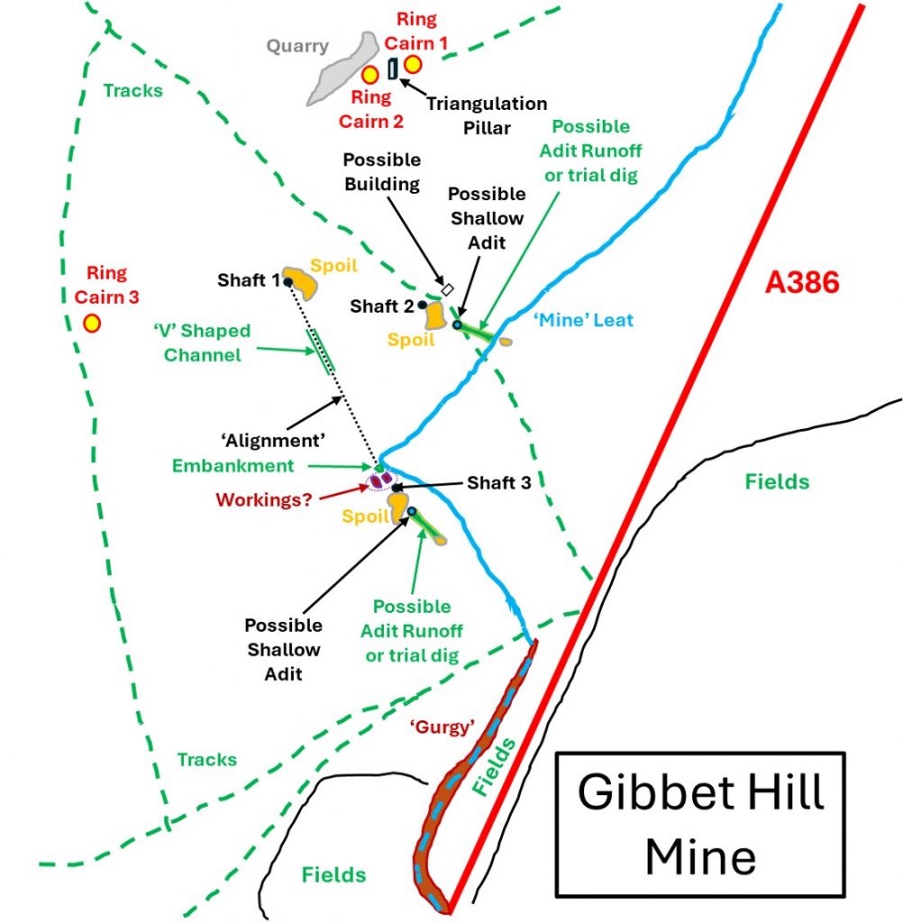
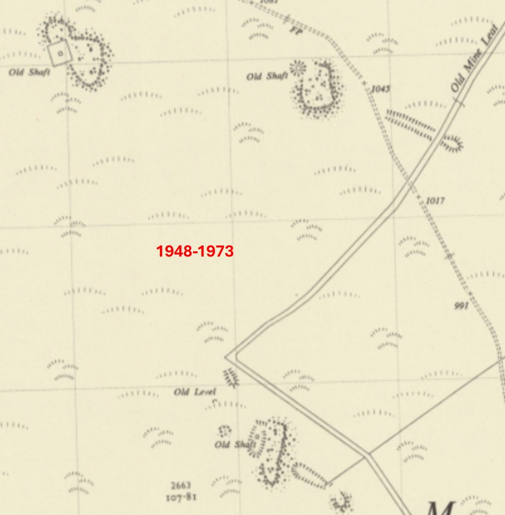
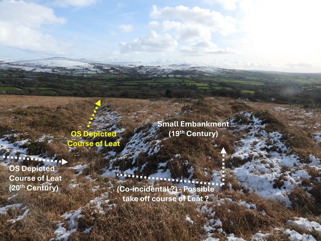
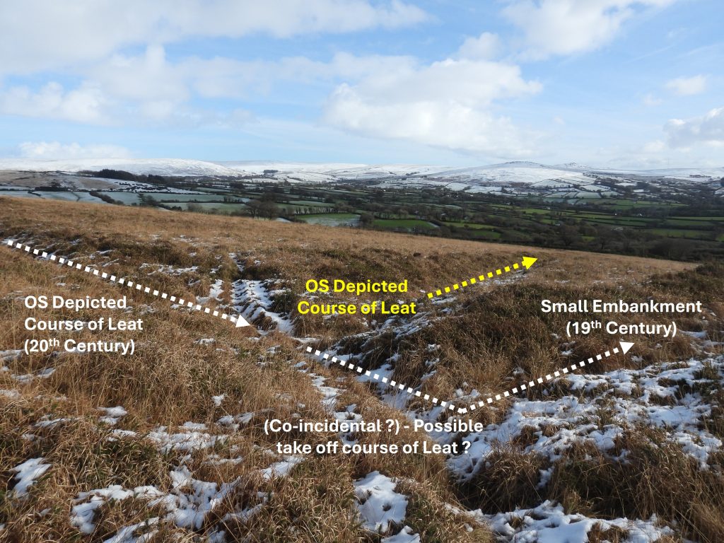
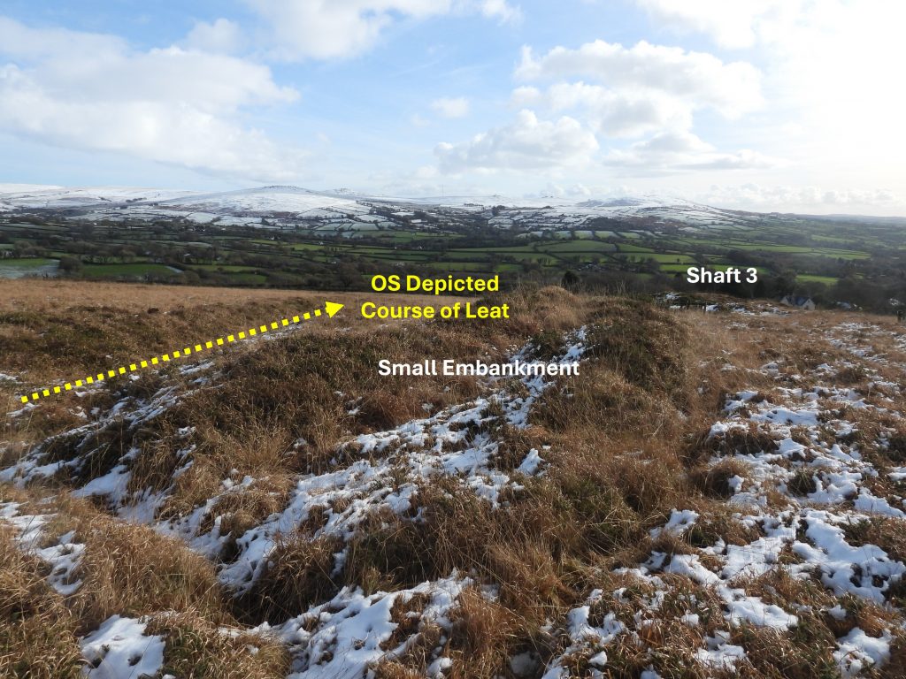
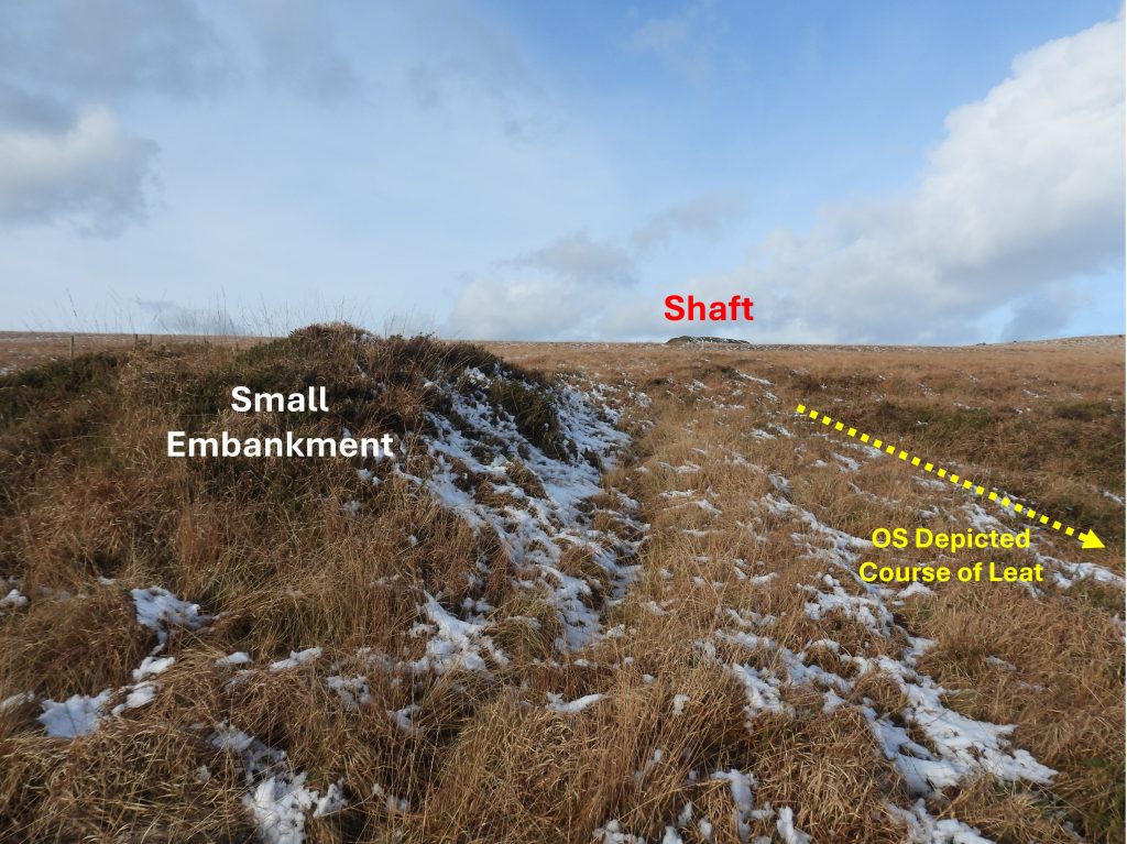
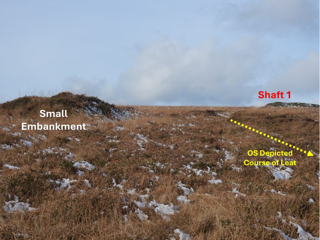
This sketch map shows the key features covered in this post. The author speculates, in particular about the function of the small embankment, ‘V’ channel, shallow ‘runoffs’ from shafts 2 and 3 and the location of the 90 deg bend in the ‘Mine Leat’ as depicted on modern OS MapsThe post starts with an exploration of the summit of Gibbet Hill. As one ascends the Hill, there are glorious 360deg views to be had. To the west, the iconic St. Michael de Rupe Church on Brentor.St. Michael de Rupe Church on Brentor is 12th century. The view beyond the church shows Bearah Tor (left) and Kilmar Tor (right) on Bodmin Moor. Many other Bodmin Moor Tors can be seen from Gibbet HillApproaching the summit of Gibbet Hill from the west, with the snow adding to the sceneGibbet Hill Quarry is likely to date from at least 19th century and is shown on OS maps of the periodGibbet Hill Quarry collageThe large pond at Gibbet Hill QuarryGibbet Hill Traingulation Pillar, with Flush Bracket S3450The Triangulation Pillar was set up in June 1946 according to OS records and then maintained in March 1975. Brentor Church and Bodmin Moor can be seen beyond the pillarView to the north east of the pillar shows (amongst others), Sourton Tors, Corn Ridge, Great Links Tor, Sharp Tor, Hare Tor, Arms Tor, Brat Tor and Doe Tor with possibly Dunnagoat Tors just on the horizonRing Cairn to the west of the Trig Pillar. Described by Greeves, thus: “The cairn, which has a disturbed ring bank, has a diameter of about 18 metres. It is possibly ditched”. It is located at SX50293 81136Ring Cairn to the north east of the Trig Pillar. Described by Greeves, thus: “This cairn is in the form of a very slight sunken ring about 15 metres in diameter…..A line of pits cuts through its west side”. It is located at SX50343 81174Ring Cairn to the south west of the summit of Gibbet Hill at SX49967 80868. Described by Greeves, thus: “In 1993 dimensions noted as approximately 22 metres in external diameter with the ring bank being a maximum of approximately 7.0 metres wide by approximately 0.5 metres in height. It is in a ‘classic’ position on the top of modest crest”.Onto the Gibbet Hill Mine area. These two maps show the three shafts and spoil tips, which Dines (The metalliferous mining region of south-west England – page 710) states were reputed to have been trials on E -W tin lodes and were carried out about 1870 without success. It is known that pyrite, vein quartz, chlorite and arsenopyrite and some galena were found, which may discount Dines statement about tin. Of interest, is that neither map shows the ‘Mine Leat’ which passed alongside the bottom shaft (number 3 on sketch map), therefore suggesting it hadn’t been dug in the 19th century. When the author first saw a small embankment to the north west of the bottom shaft (number 3) and the fact that in lined up with the top shaft, thoughts had turned to there being a water wheel here using water from the leat then driving flat rods up the hill. Modern Lidar plot of the area, showing the shafts plus now the ‘Mine Leat’. Crossing mentions the leat in his ‘Guide to Dartmoor’ (page 159) stating: “Remains of mining operations occur on the side of the hill. It was to these workings that the water was brought in the leat we have noticed at Barrett’s Bridge. After being used it was suffered to run into a deep channel known as a Gurgy and was by means of this carried to the Cholwell Brook”. Due to the presence of Galena (see picture), which is also called lead glance*, this post has been categorised under Lead Mining. This couples with the fact that the nearby Wheal Betsy was basically a Silver-Lead Mine, albeit a little copper and arsenic was also mined. *Lead glance is the natural mineral form of Lead Sulphide (PbS) and is the most important ore of lead and an important source of silver.
On the subject of minerals found here, the author is grateful for this short piece on the geology of the Black Down (Gibbet Hill) area by Dartmoor Chris. The geology here is quite different to large swathes of Dartmoor as it consists of metamorphosed shales and grits of the Culm Measures. The mound of the hill is classed as Cryoplanation (Altiplanation) Terraces. Cryoplanation is a term used to describe the formation of plains, terraces and pediments in periglacial environments. These are bedrock steps or terraces on ridge crests and hilltops with the treads ranging from 10m to several hundred metres wide. They were formed by the combined action of frost shattering and nivation at the end of the last ice age. Pockets of ice sheets were left as they retreated north due to the sun not assisting in the thaw. The melt waters washed down sediments from the base of the ice creating erosion by tiny streamlets on the downslopes. On the metamorphic aureole of Dartmoor, there are a number of similar hills and tors that fall into this category. Here’s a few that have been listed – Black Hill, Peek Hill, Whitchurch Down, Cox Tor, White Tor, Cudliptown Down, Great Nodden, East Hill, Lake Down, Smeardon Down and Sourton Tors.
Spoil tip from shaft 1 has an unusual flat topShaft 1 and its associated spoilThe flat top of the spoil tip of shaft 1 looking towards the top of Gibbet HillShaft 1. There is circumstantial evidence that the mine possibly being part of North Wheal Friendship can be found in Collins (p.486) where he quotes 319 tons of lead ore being produced between 1854-57 referable to North Wheal Friendship on Black Down. Perhaps this may be from both Wheal Betsy and Gibbet Hill Mine. If so, this would date this mine to nearly 20 years before Dines reference !Shaft 1 is located at SX50203 80911Shaft 1 from the spoil tipLooking south east across Shaft 1, a shallow ‘V’ shaped channel can be seen. Its alignment runs to the west of the spoil tipNear Shaft 1, there was this rock which appears to be a XenolithLooking up at Shaft 1 near the Xenolithic rock with a horse rider passing by (whom the author thinks was part of some cow herding which had taken place on the west side of the hill)View from below Shaft 1Close up of the dump (spoil) of dark grey killas of Shaft 1A short distance downhill from Shaft 1 is a shallow ‘V’ shaped channel, which appears man-madeThe top of the ‘V’ channel is located at SX50212 80880The ‘V’ channel is around 63m longThe bottom of the ‘V’ channel is at SX50242 80824. The channel is very straight and appears to cut through a small crest in the hill between Shafts 1 and 3, which to all intents and purposes it looks like a channel for flat rods used for pumping – the alignment to the 90 deg bend and small embankment by Shaft 3 making for further circumstantial evidence that this was the case Onto the next highest of the workings -Shaft 2 and its associated spoilShaft 2 at SX50354 80887Looking across Shaft 2 in a north west direction towards Shaft 1 spoilView looking south east from Shaft 2 spoil. Note the shallow channel (workings) in the centre of the picture which could be an adit run off or just a trial dig ‘chasing the lode’ up the hill. Also, of interest, is the dark line (left to right) which is the ‘Mine Leat’, which bisects the shallow channel and some spoil. This is probably further evidence that the leat was constructed after the workings had been dugZoomed in view of the leat, spoil and adit runoff / trial dig. Were these trial workings chasing a lode or possibly the run off of a shallow adit which was used to tram ore from Shaft 2. The author suggests on the balance of probabilities these workings were just chasing a lodeTop of the spoil tip from Shaft 2. Like the spoil from Shaft 1, the top here is very flat. Is this natural weathering or the fact that the spoil was ‘picked over’ and deliberately flattened?Top of the spoil and Shaft 2 with Shaft 1 spoil uphillClose up of the dump (spoil) of dark grey killas of Shaft 2Spoil tip next the Shaft 2Ponies near Shaft 2This annotated 20th century map shows (unlike its 19th century counterparts) the course of the ‘Mine Leat’. Mine Leat – constructed around 1910/11 looking towards Kingsett Down and in the far distance Tavy Cleave, where the water would have originally come from – quite a distance!The Mine Leat looking south west towards the lower workings near Shaft 2Mine Leat looking north east. Although now disused for over 100 years, the Mine Leat is still deep enough to collect waterLooking uphill towards Shaft 2 and its associated spoil tip from the point where Mine Leat crosses the lower workings. Was the shallow channel seen here ‘chasing a lode’ or was it a adit runoff The Mine Leat looking north eastThe Mine Leat looking south west from beyond the lower workings of Shaft 2More water in Mine Leat as it approaches Shaft 3Mine Leat near Shaft 3 (the fencing around the shaft can just be seen)The point where Mine Leat turns 90 deg (as shown on OS Maps). The water from the leat could easily have been diverted across the small embankment (albeit that would have been 40 years plus old) to feed a waterwheel beyond? The small embankment aligns with the ‘V’ channel further uphill and onto Shaft 1. A fanciful notion perhaps but the co-incidents are there.Of course, if the small embankment from the 19th Century was being employed by the 20th Century miners, then it would suggest Gibbet Hill Mine was being operated at the later date than first thought. The small embankment is located at SX50291 8010Although the small embankment was built around 40 years before the Mine Leat, of interest is that there doesn’t appear to be any pits or workings next to it, which is a bit of a conundrumThis ‘rectangular’ section near Shaft 3 looks like old workings. The (rectangle) shape is clearly shown on the Historic Environment Record mapThis angle shows the alignment of the small embankment and Shaft 1 In spite the circumstantial evidence of the alignment of the embankment and the previously mentioned ‘V’ channel suggesting flat rods potentially being used, this can be counter argued by the age difference between the embankment and the leat plus the fact that no wheelpit was found. It is likely that the 20th Century leat constructors just wanted to get as far along the hill as possible and decided the Shaft 3 workings were far enoughShaft 3 and working close by. Had there been a wheelpit here, it would have been located where this working is located.Workings associated with Shaft 3 looking towards Shaft 1Shaft 3 (unfenced) is located at SX50310 80662Looking south east from Shaft 3. Like Shaft 2, were these trial workings chasing a lode or possibly the run off of a shallow adit which was used to tram ore. The author suggests on the balance of probabilities these workings were just chasing a lodeLooking uphill into the ‘adit runoff’ or lode chased gullyThe Mine Leat below the 90 deg turn. There is also a drain here running north – south shown at the bottom of the photographThe Mine Leat run off, which would have lead to Cholwell Brook via the GurgyTop of the Gurgy by the A386. William Crossing takes the name for this deep channel from the word Gurges (a whirlpool)The Gurgy runs parallel to the A386 for a few hundred metresLast view of the Gurgy before it turns towards the A386 en-route to Cholwell Brook. Courtesy of Dartmoor Chris – another reference to a “Gurgie”… In a case of the Lords of the Manor’s – Duke of Bedford & Sir Ralph Lopes over a dispute of the River Tavy… some old documents were submitted and the Doomsday Book recorded “Buckland” parish with the abbots had to keep the “Gurgie” repaired which is the weir…