A collection of walks, discoveries, insights and pictures of exploring Dartmoor National Park
December 22, 2020
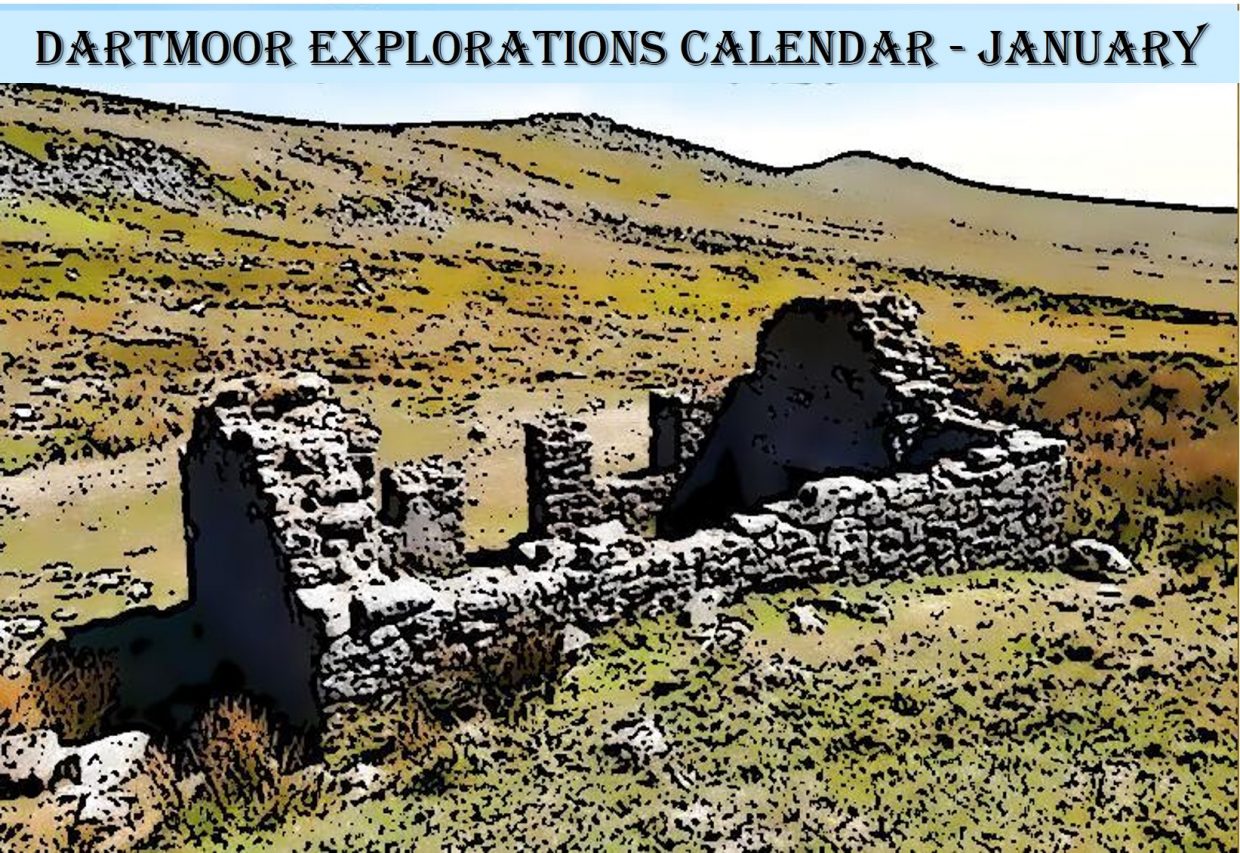
DARTMOOR EXPLORATIONS CALENDAR – JANUARY
In 1991, the Dartmoor National Park Authority (DNPA) published a spiral bound diary to commemorate their fortieth anniversary (1951-1991), called “The Dartmoor Diary”.
Inspired by this publication (and some of the entries in it) and to celebrate the DNPA 70th anniversary year in 2021, the “Dartmoor Explorations Calendar” records an event or story, complemented with photographs for each day of the year.
This page of the Dartmoor Explorations Calendar celebrates January on Dartmoor and its immediate borderlands.
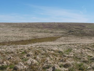
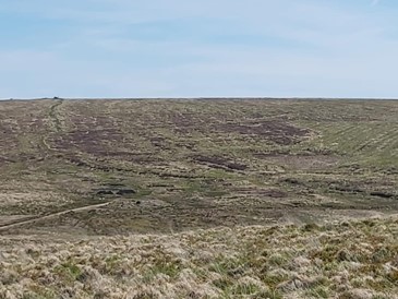
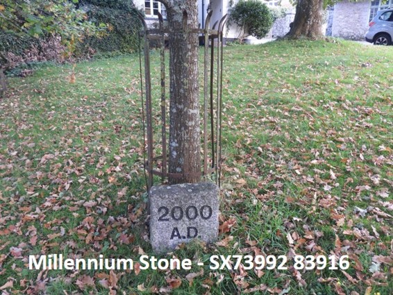
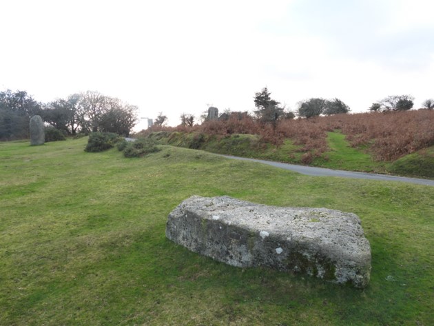
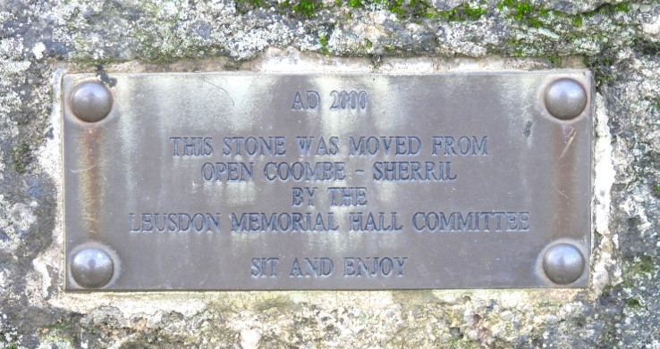
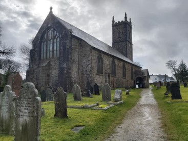
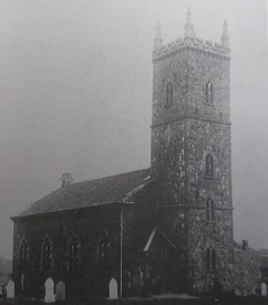
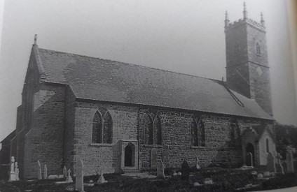
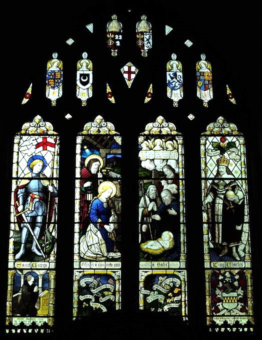
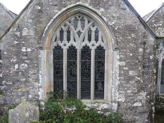
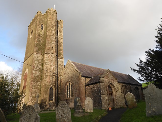
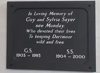
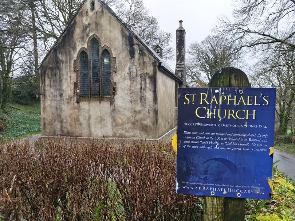
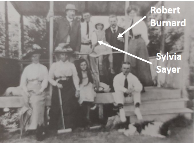
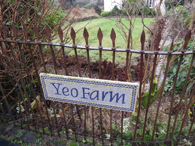
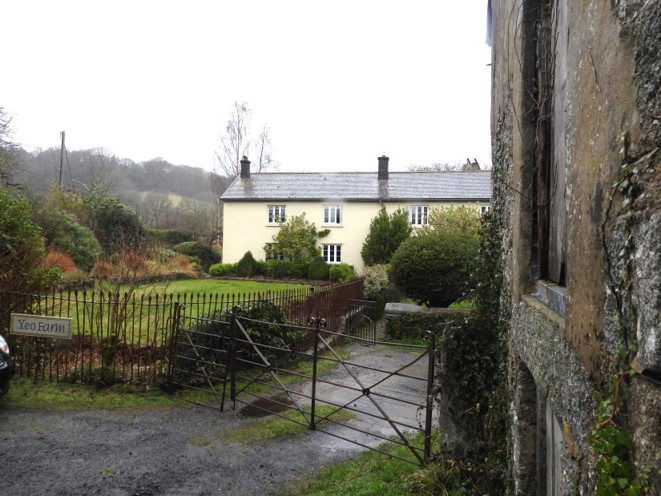
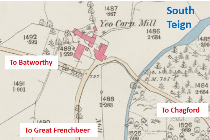
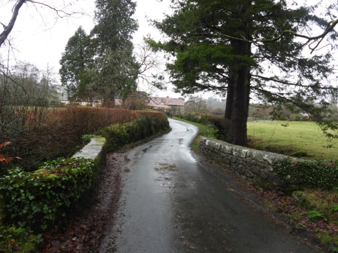
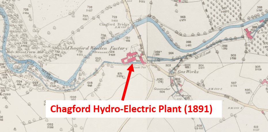
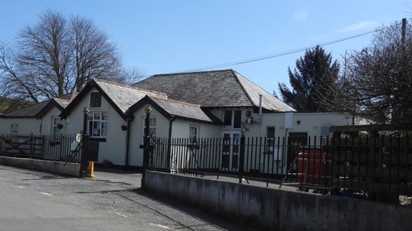
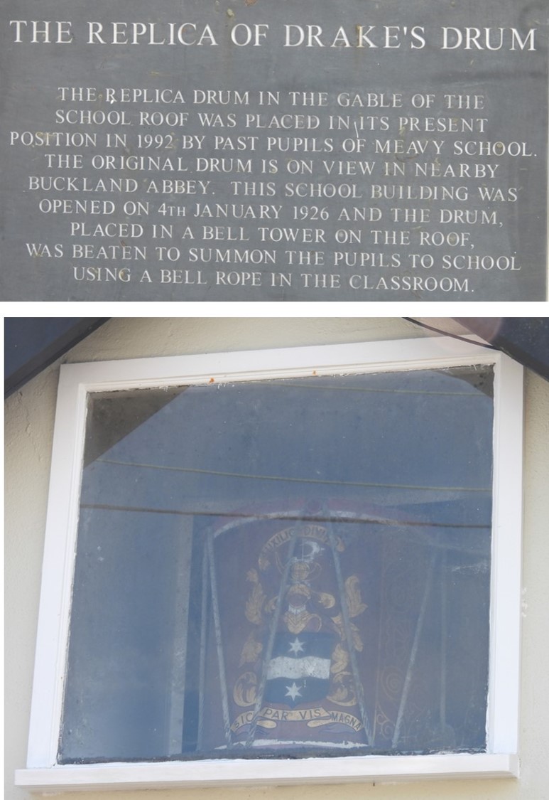
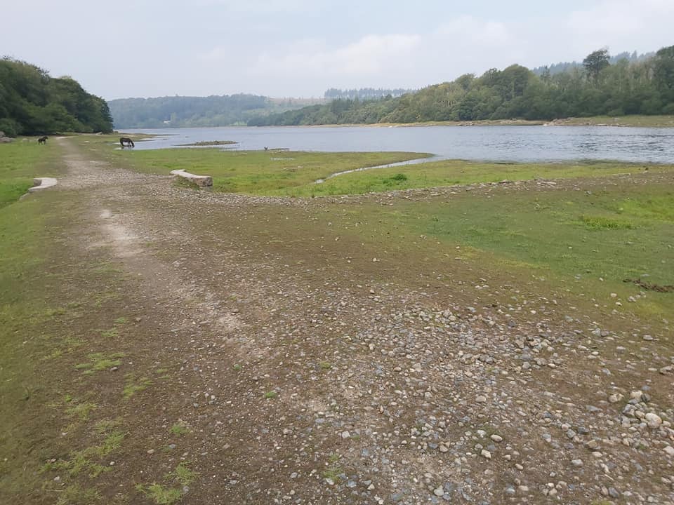
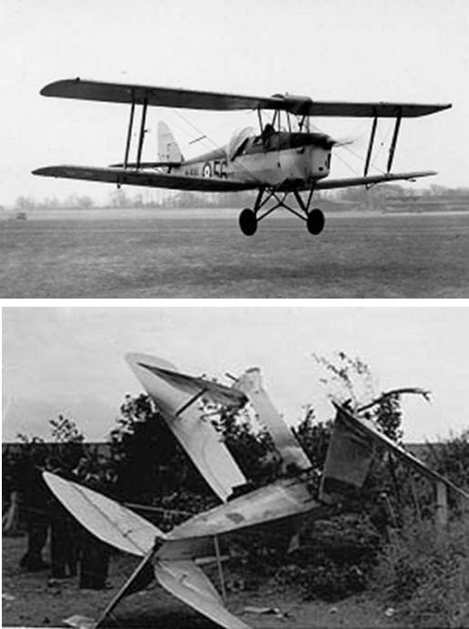
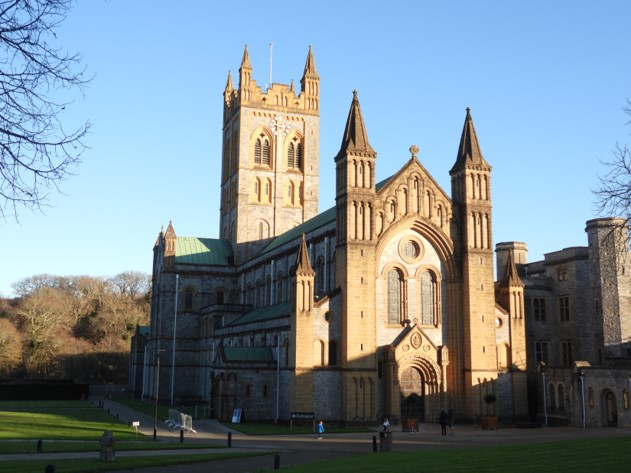
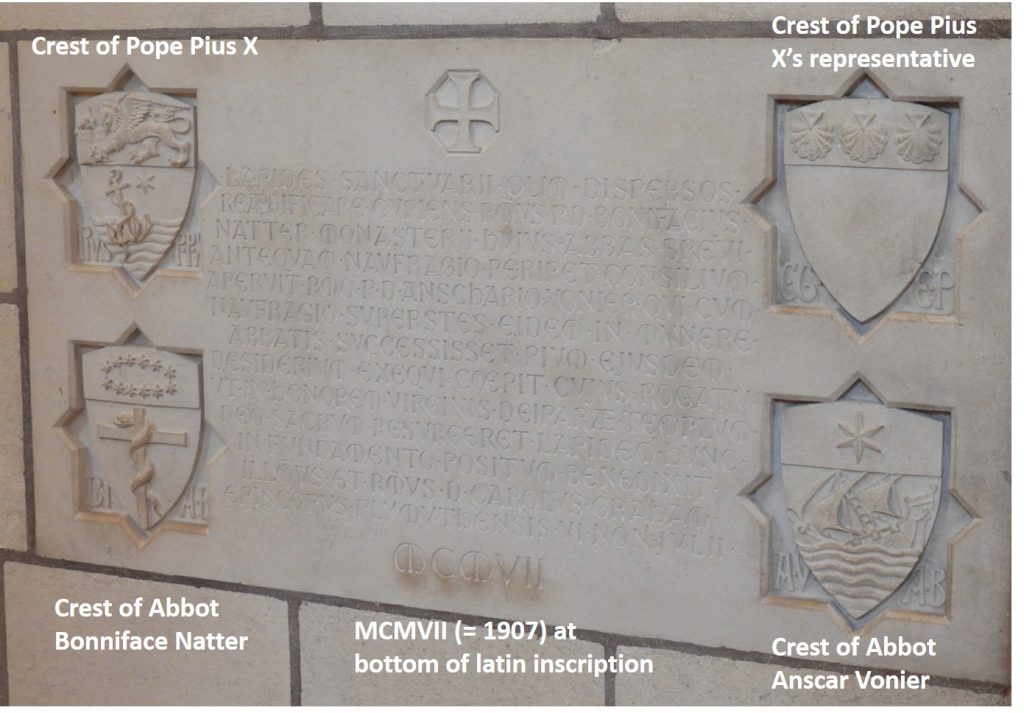
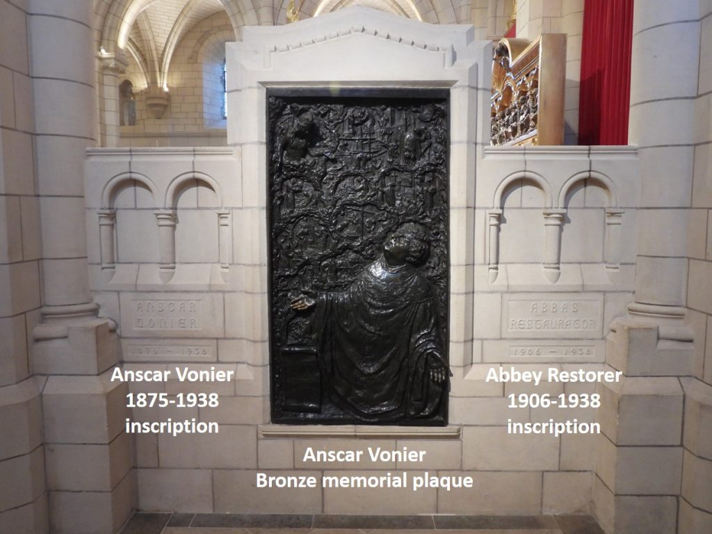
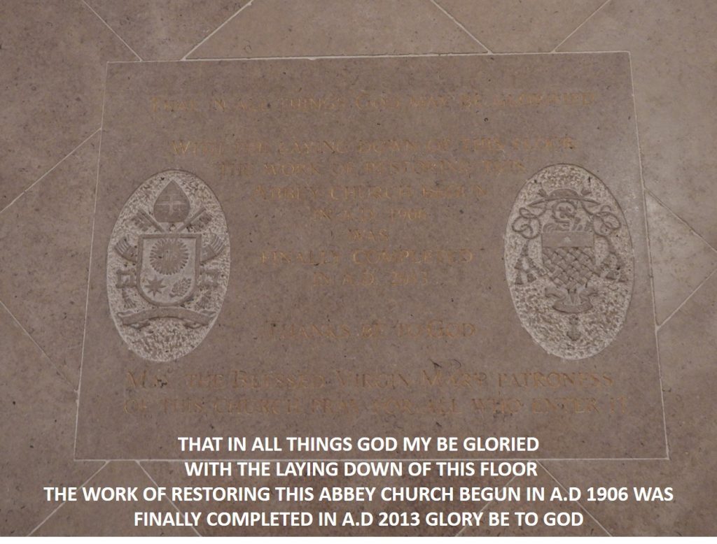
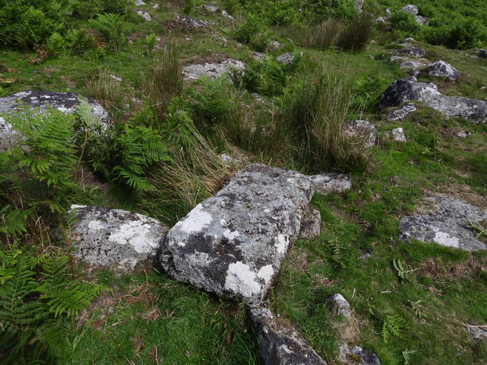
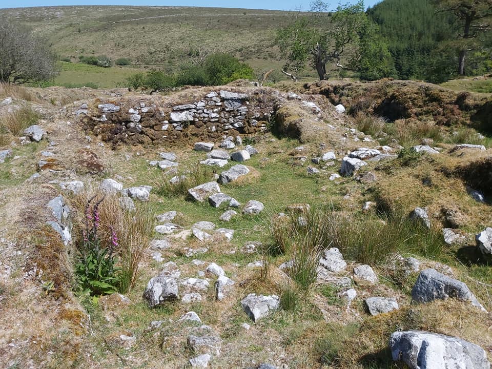
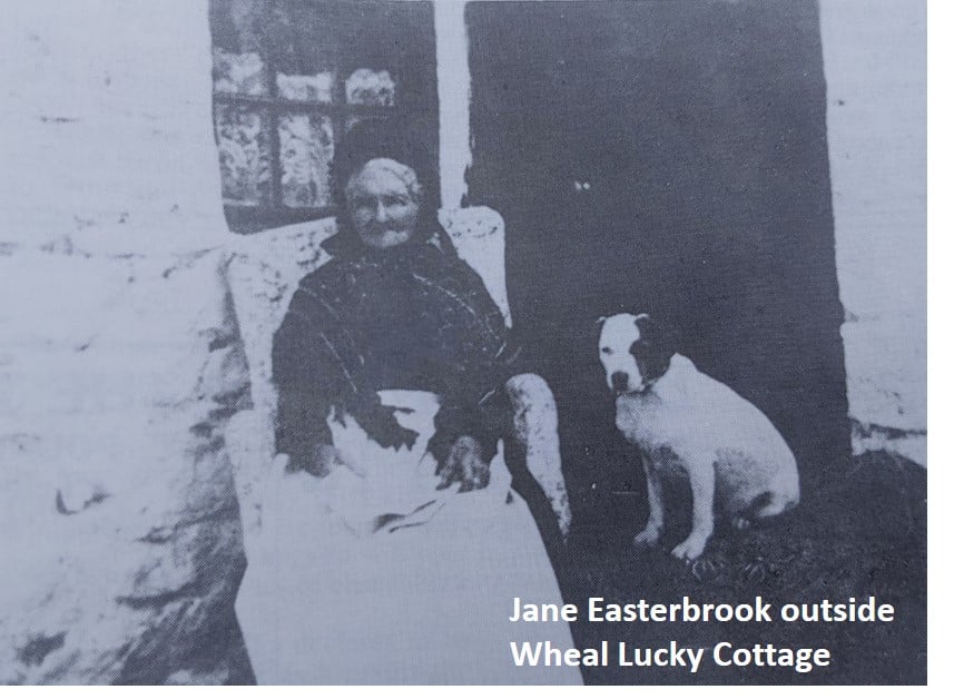
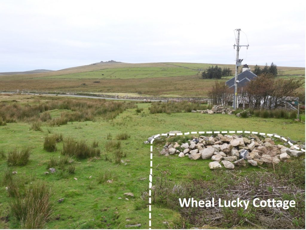
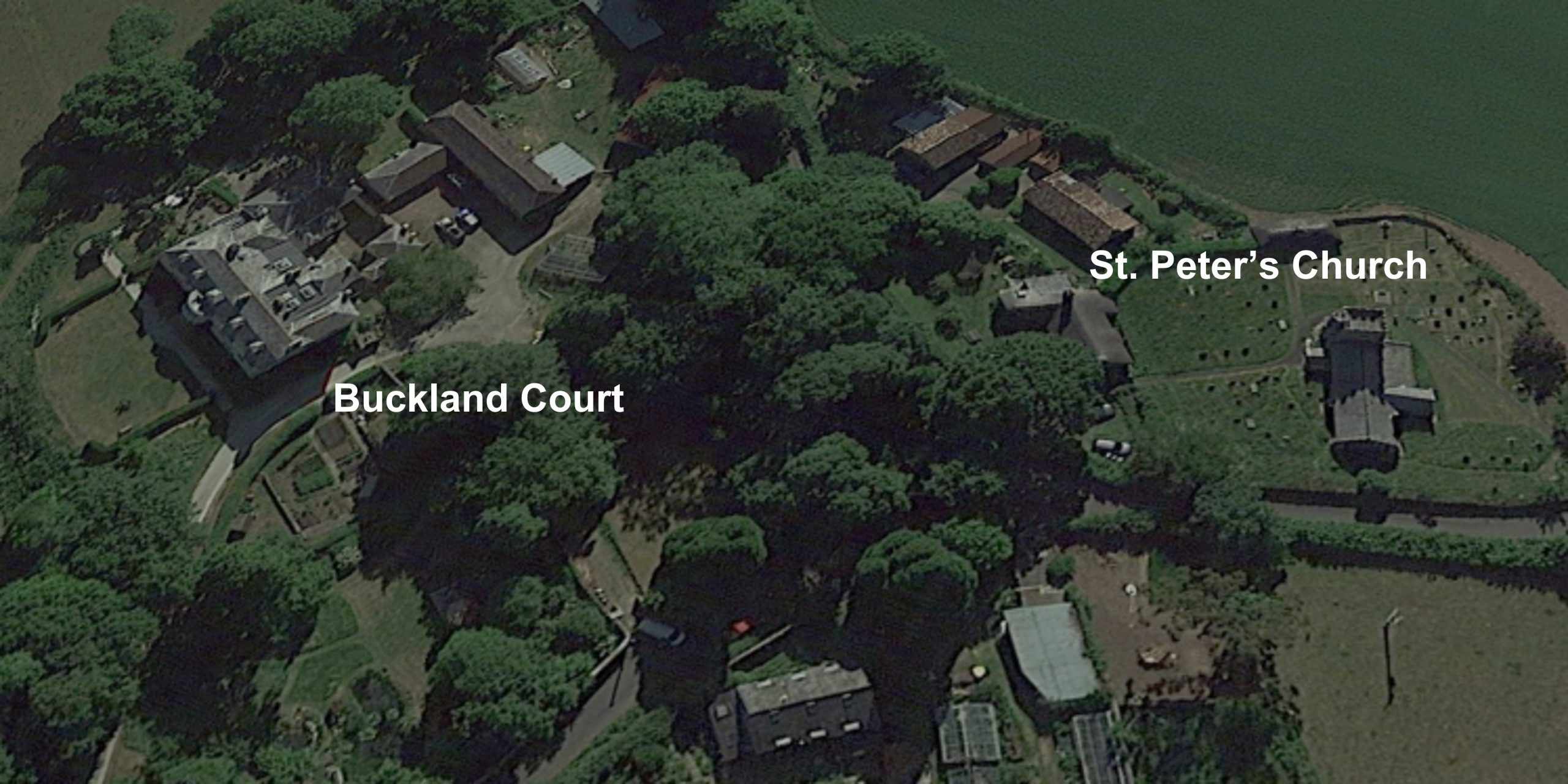
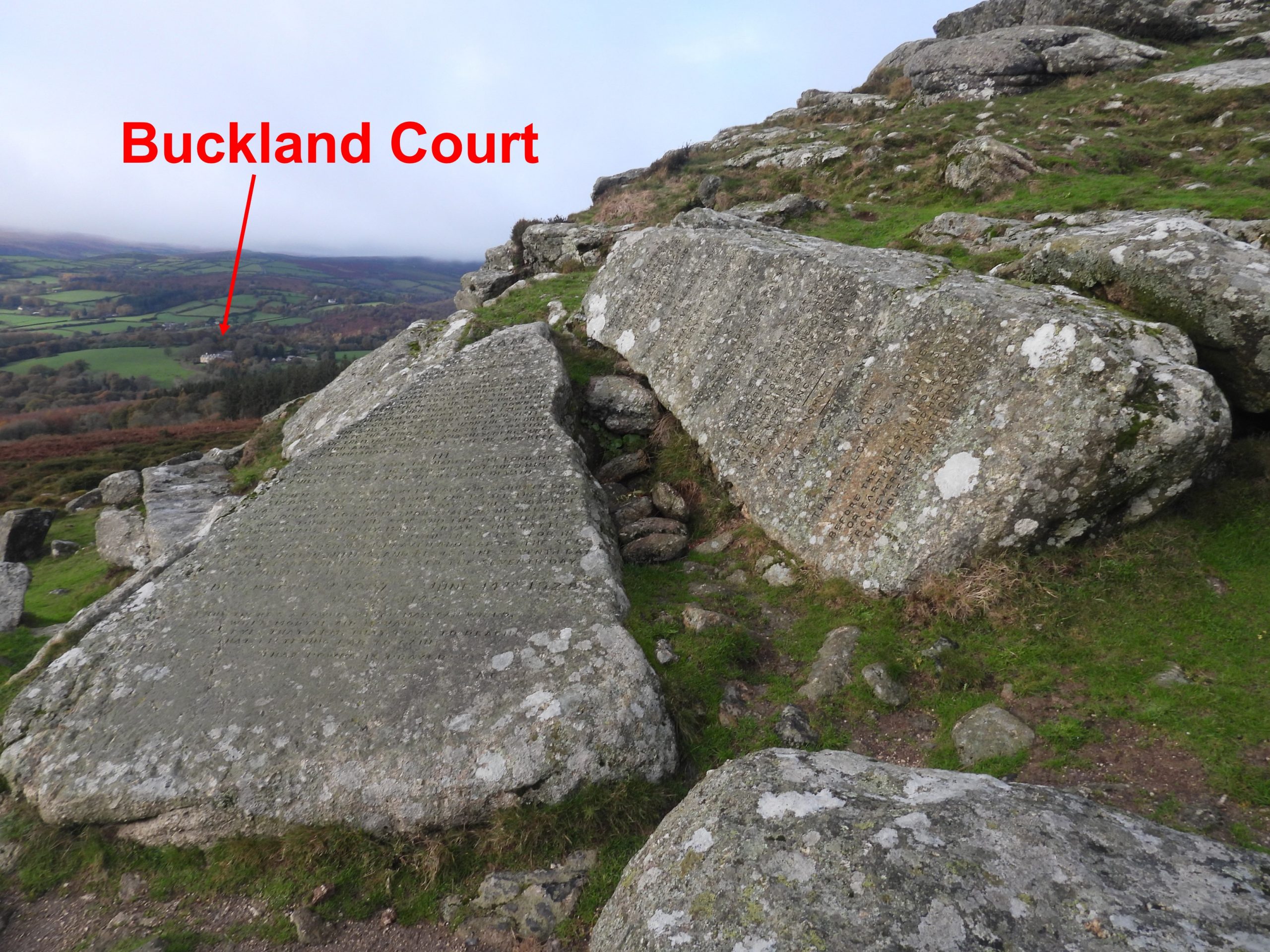
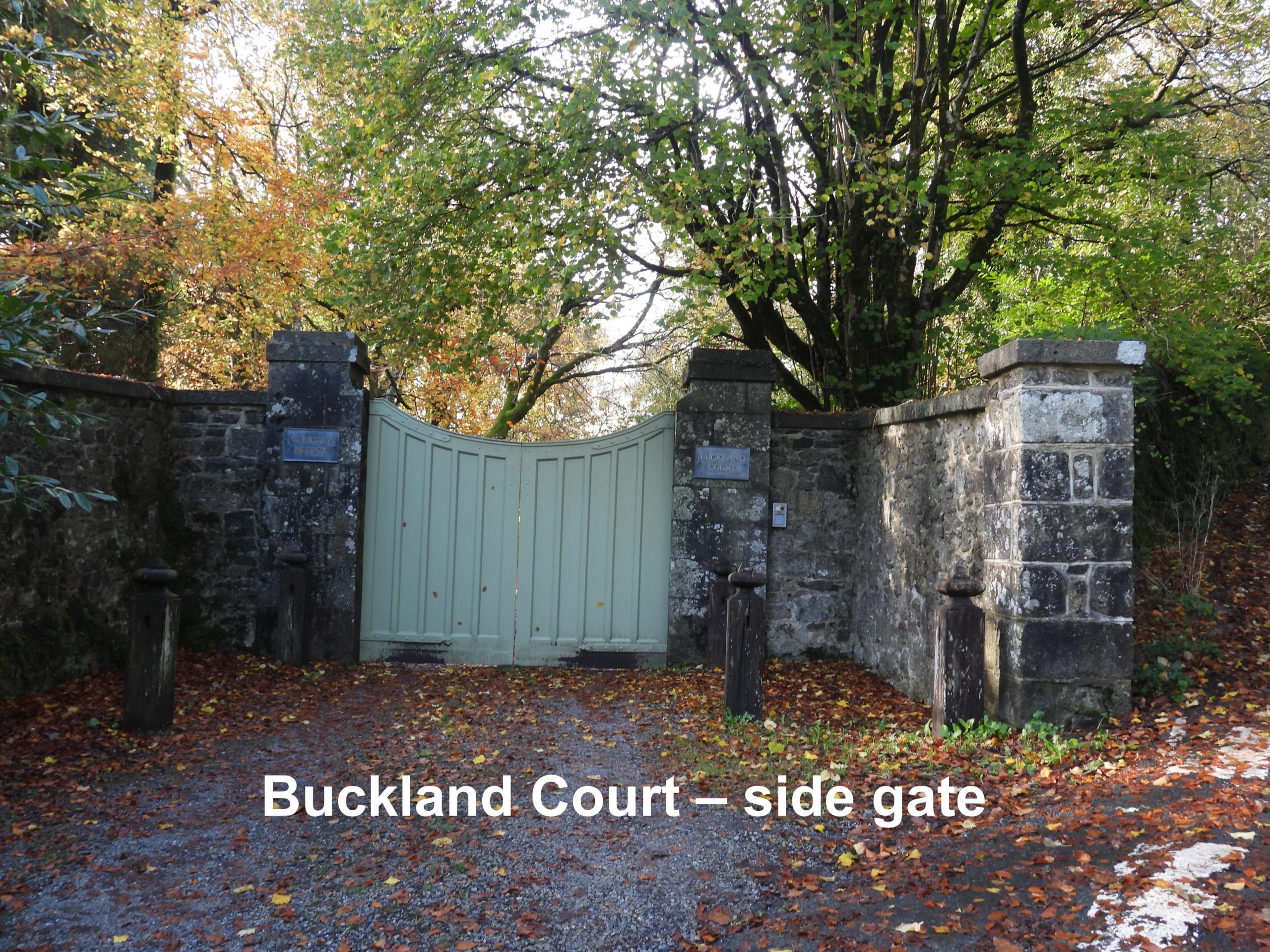
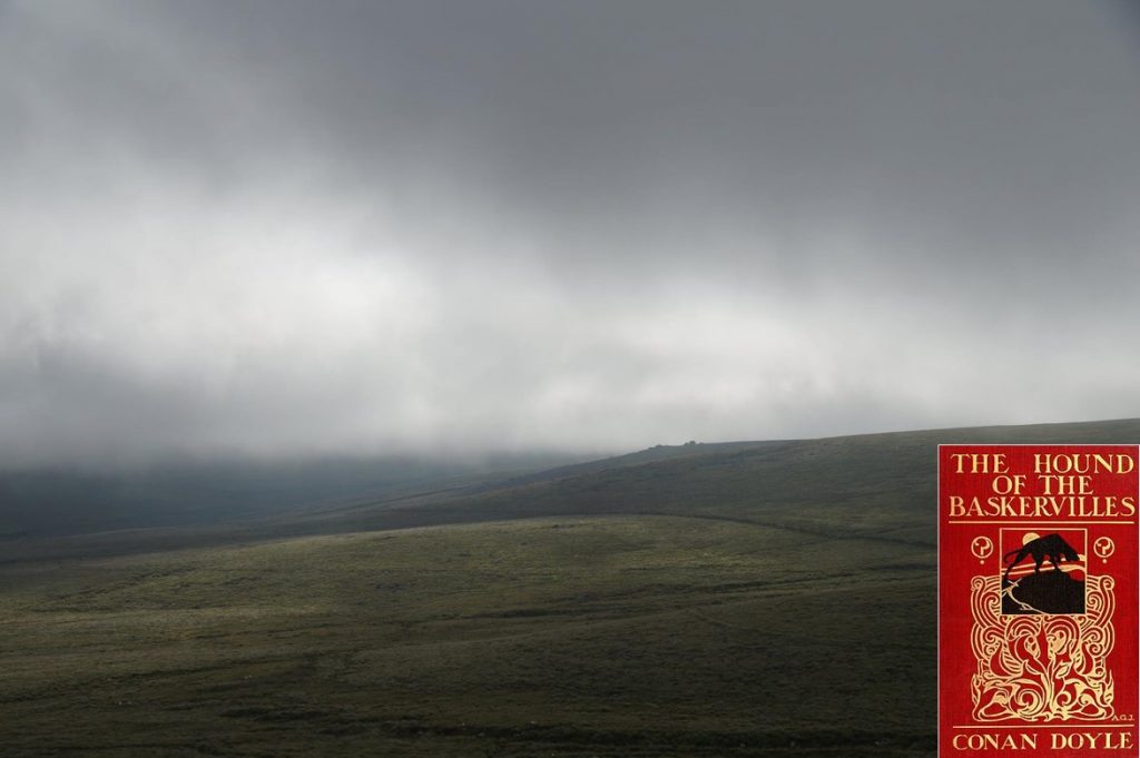
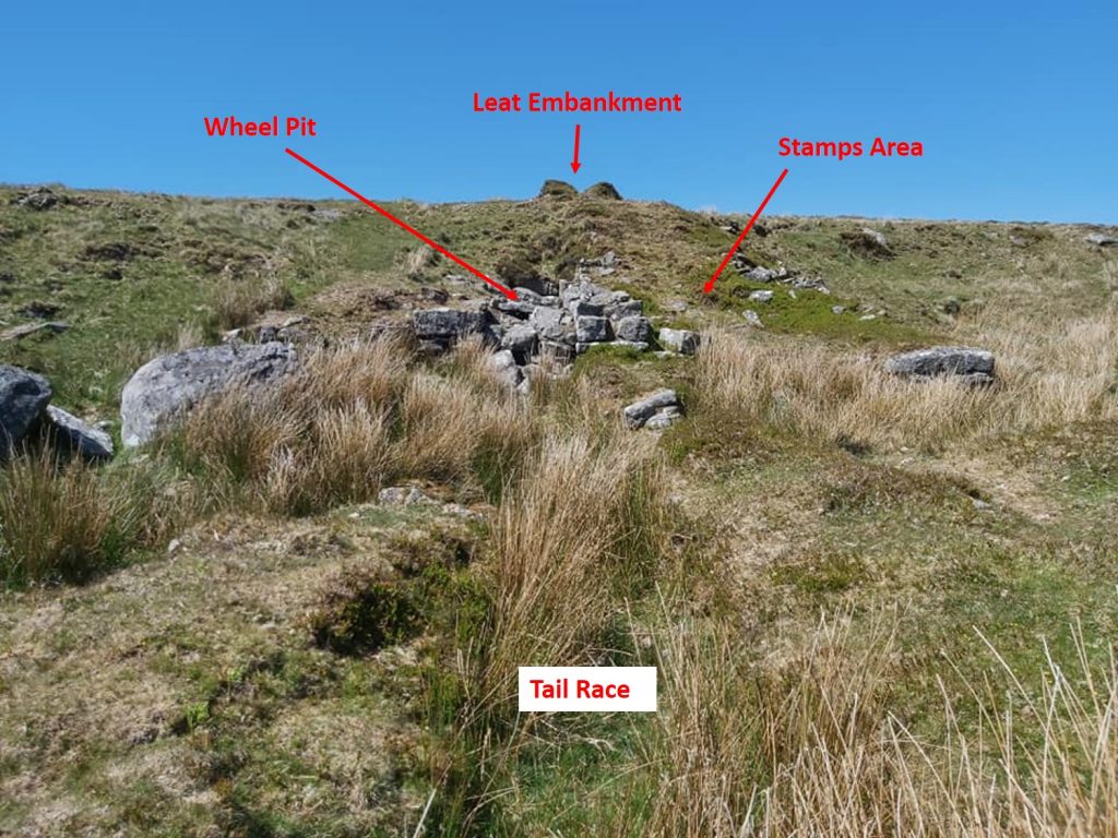
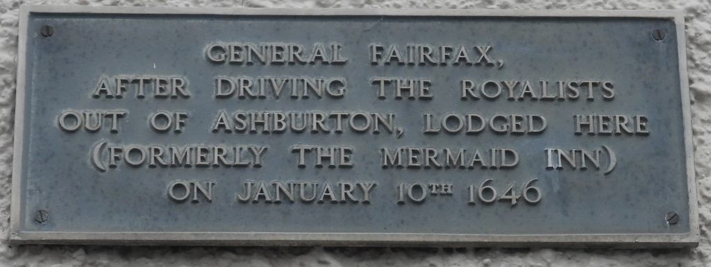
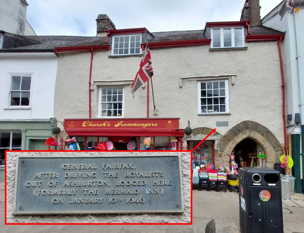
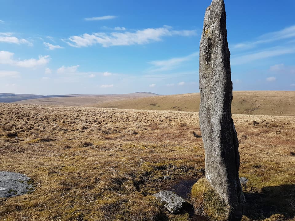
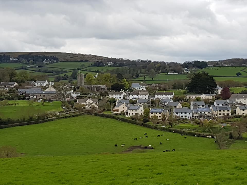
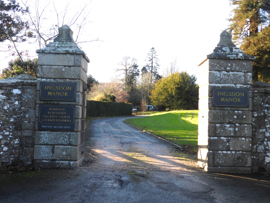
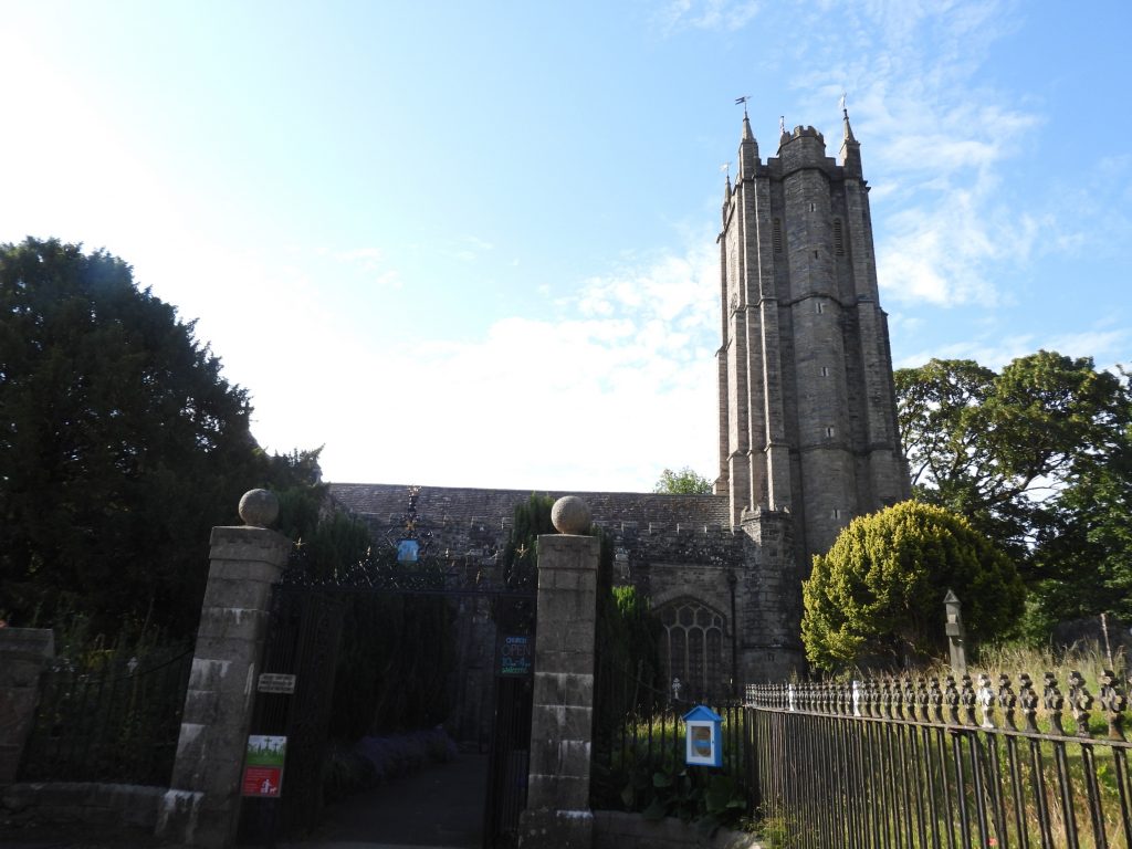
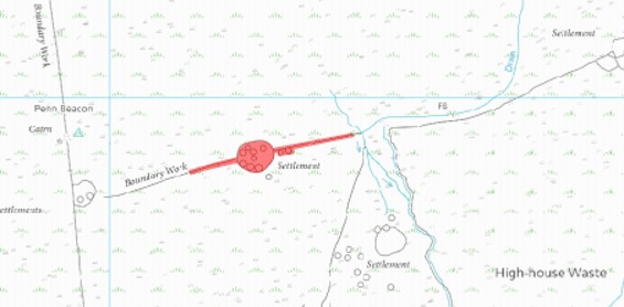
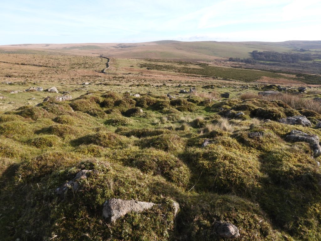
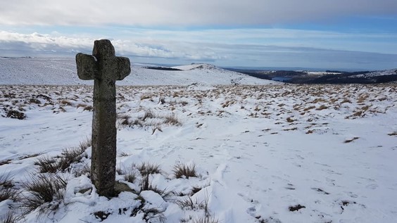
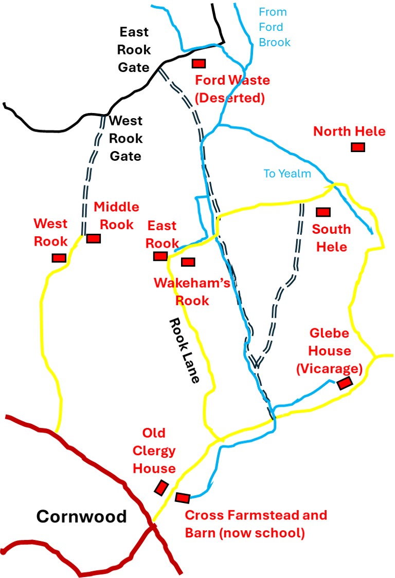
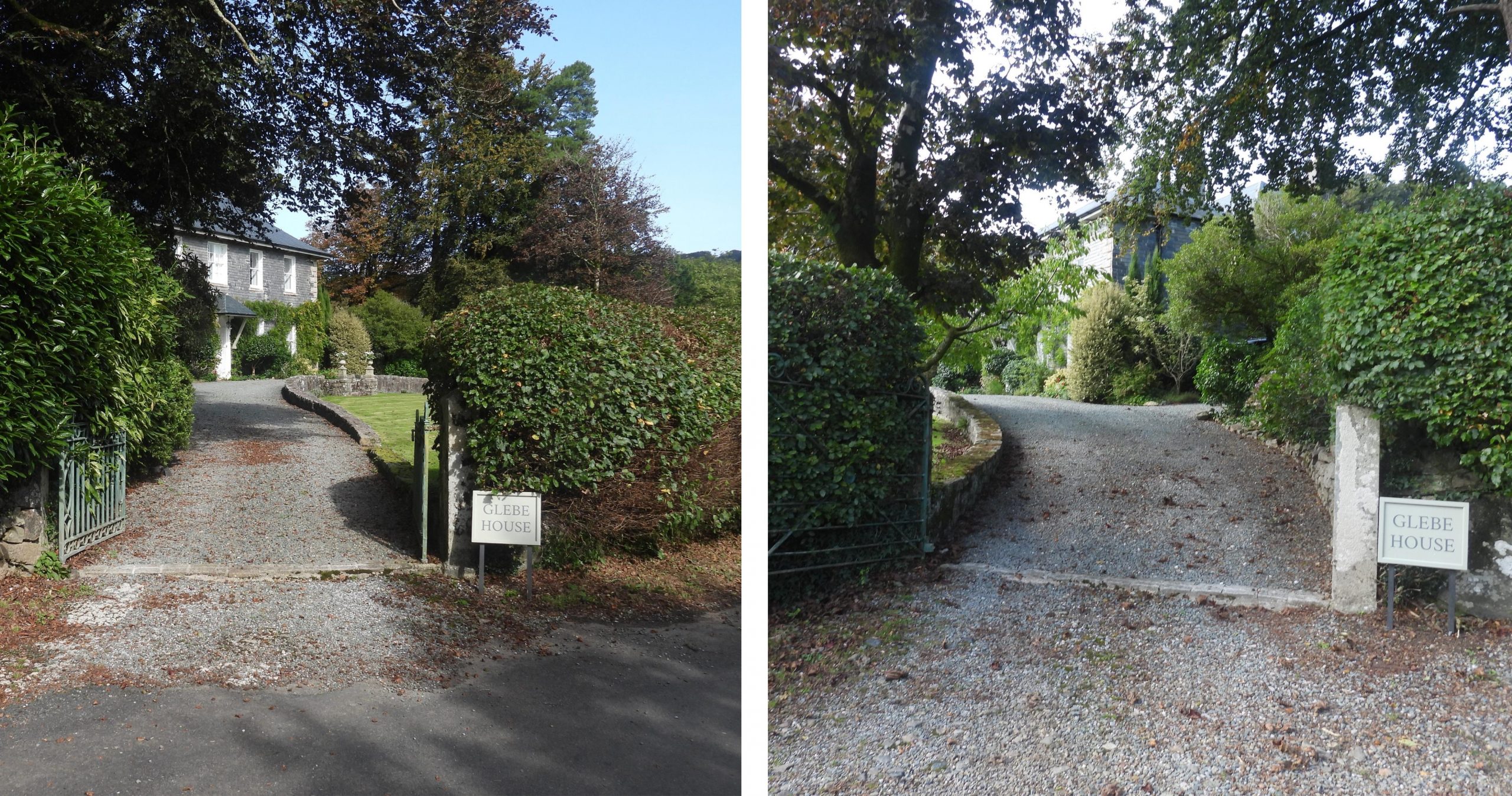
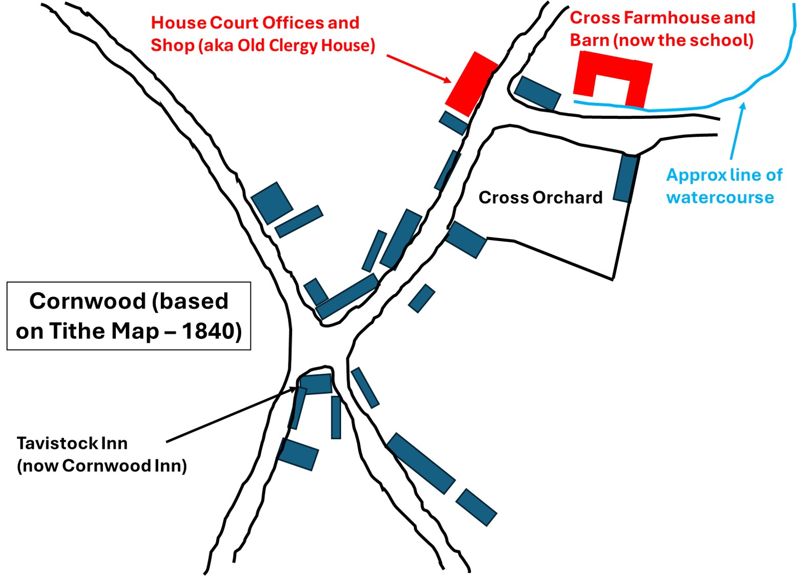
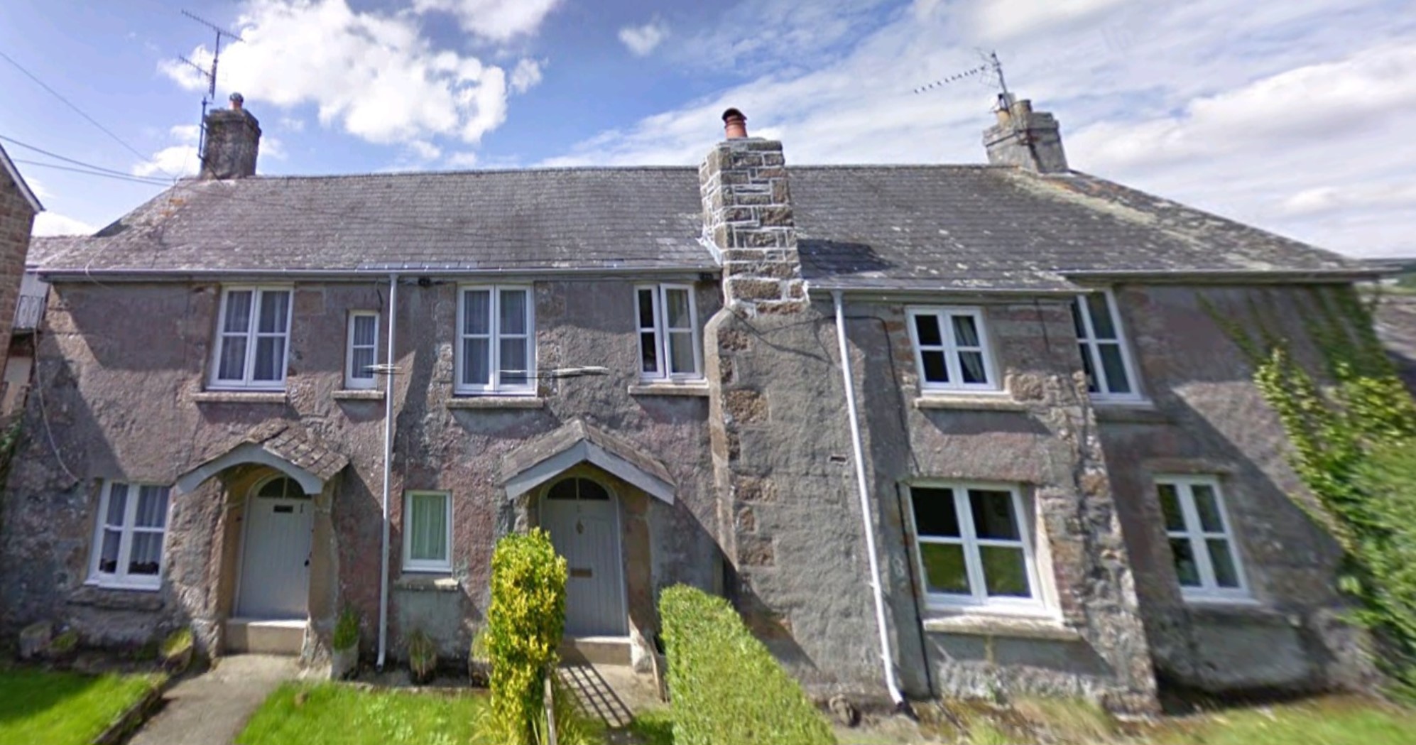
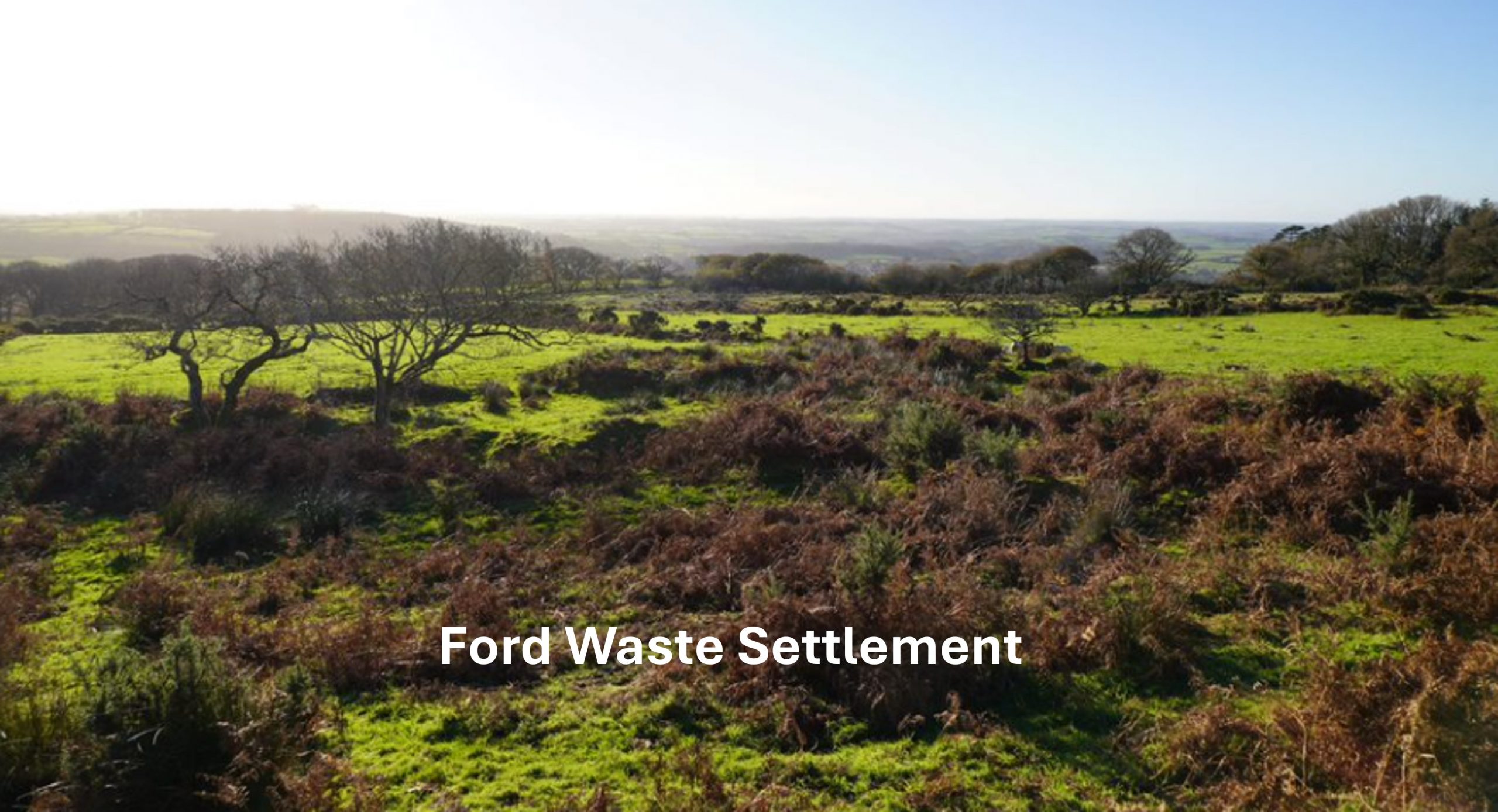
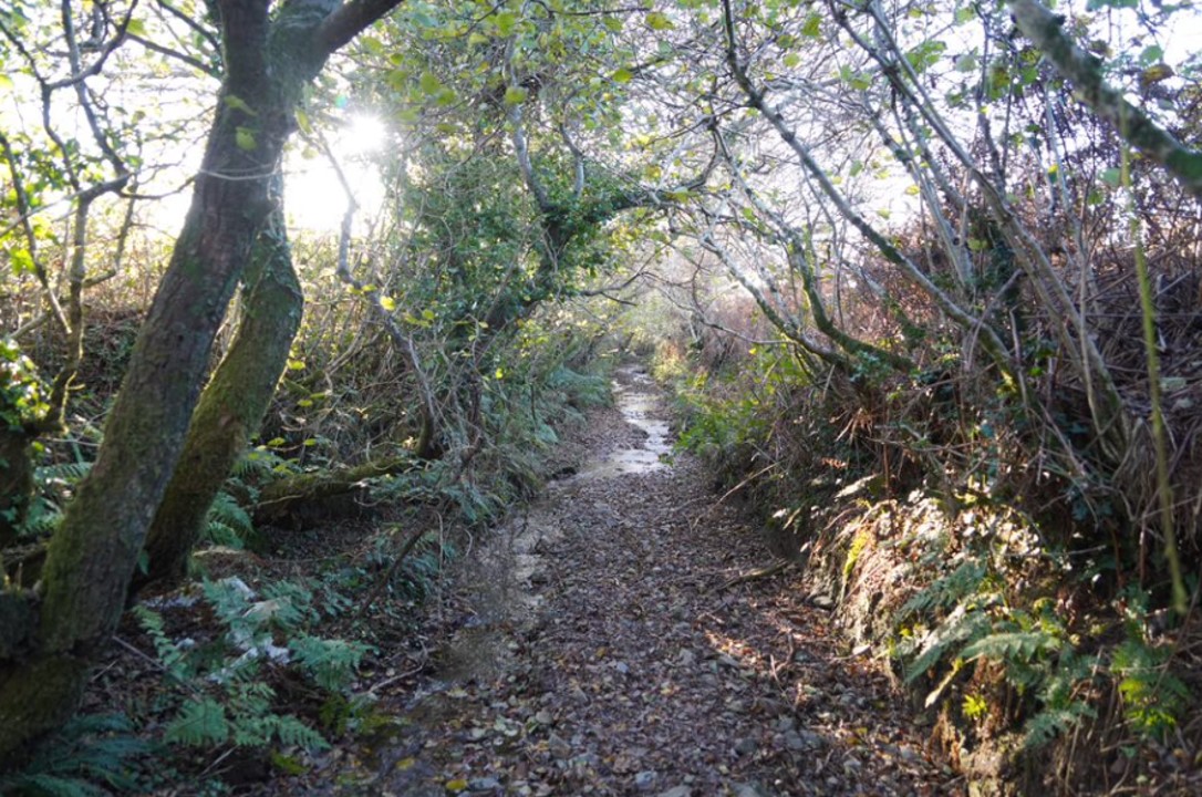
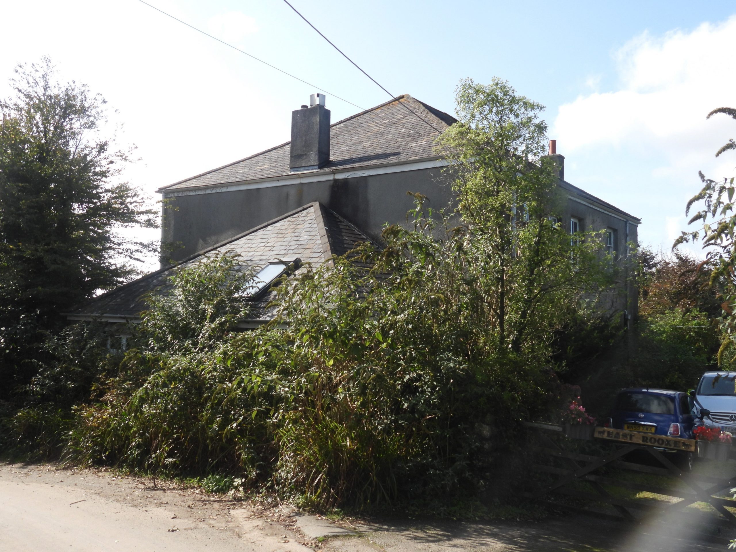
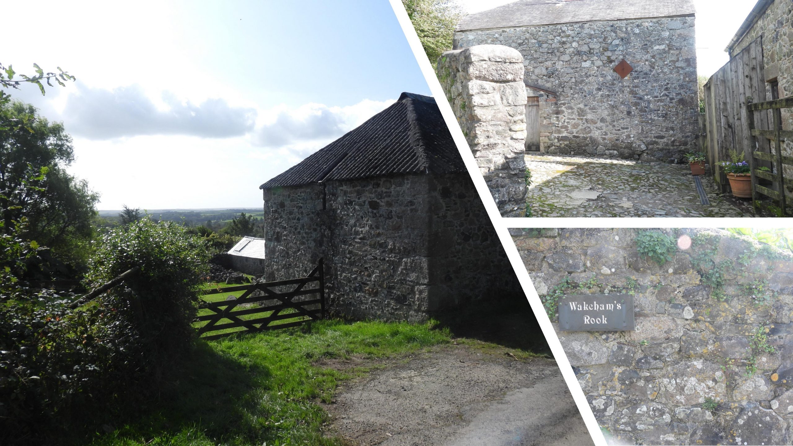
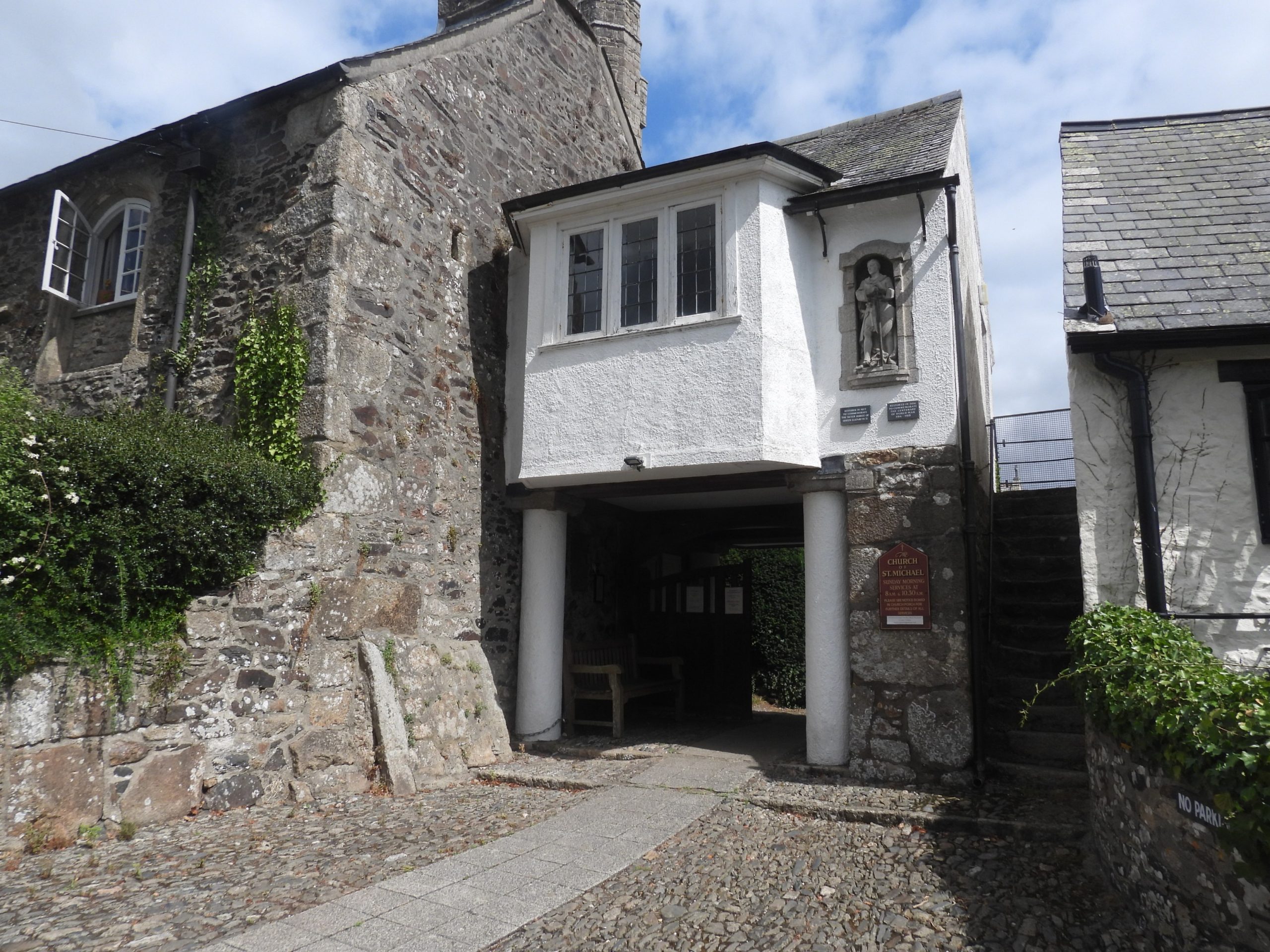
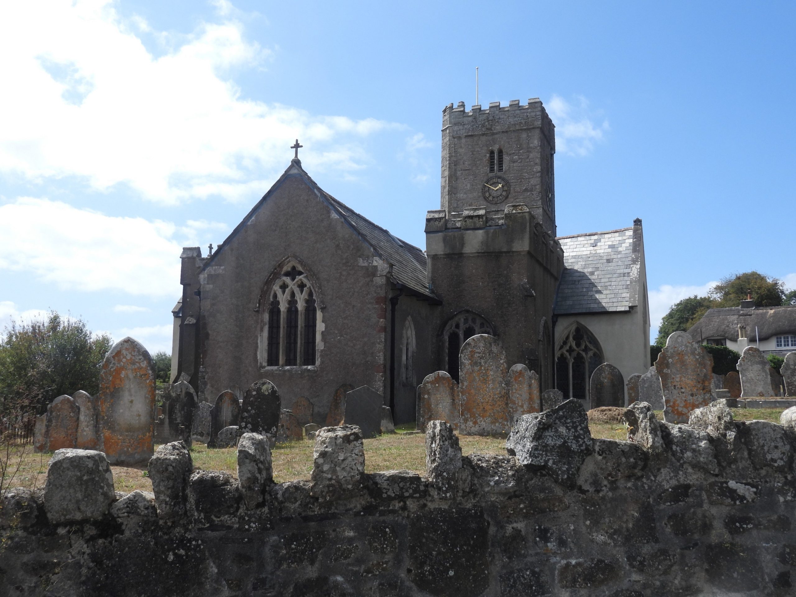
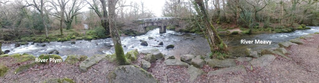
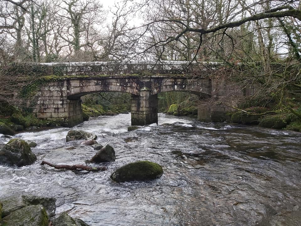
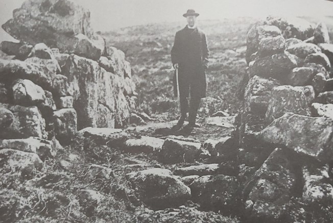
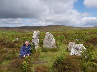
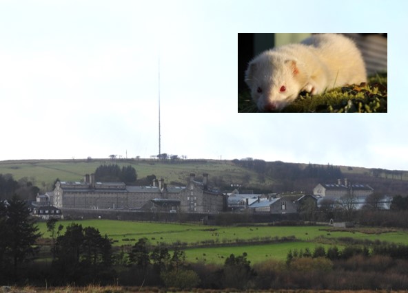
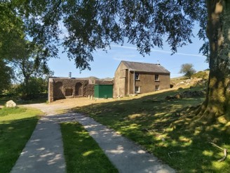
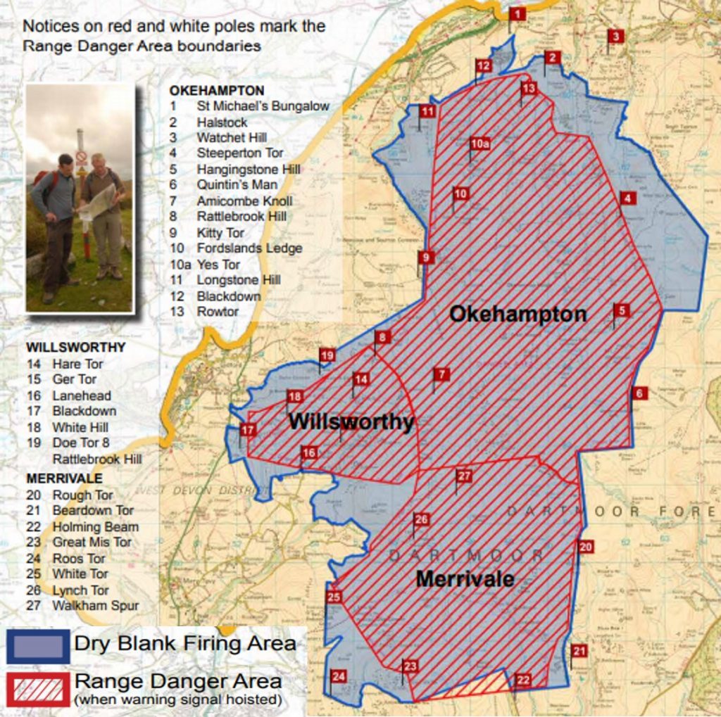
1st January 1867: The Rattlebrook Head Peat sett licence was granted to Joseph and William Mathews. They were also granted the Doe Tor Sett on the same terms. The view of this photograph is of the the railway embankment, which carried the line (which had standard gauge rails) the last few hundred metres to the works, which dates from around 1870’s. (Source: Domestic and Industrial Peat Cutting on North-Western Dartmoor, Devonshire: An Archaeological and historical investigation by Phil Newman)1st January 1867: The Rattlebrook Head Peat sett licence was granted to Joseph and William Mathews. They were also granted the Doe Tor Sett on the same terms. The picture is a general view of the peat works from the path leading down from Great Links Tor. You can make out the peat cutting across the flanks of Amicombe Hill up to Kitty Tor (pimple on the horizon). The sett bounds were: “On the East by a line drawn parallel to the Rattlebrook at a distance of 400 fathoms Eastward thereof. On the South in part by the Tavy Cleave, in the other part by the lower Rattlebrook and for the remaining part by the southern limit of that portion of the Common of Devon which lies northward of Hare Tor and Doe tor. On the West by a straight line drawn through the centre of Doe Tor to the centre of Arms Tor and continued thence northward to the River Lyd and On or towards the North in part by the course of the said River Lyd – in the other part by a straight line drawn due west from the Rattlebrook Head to Sandyford by the Forest boundary.” (Source: Domestic and Industrial Peat Cutting on North-Western Dartmoor, Devonshire: An Archaeological and historical investigation by Phil Newman). 1st January 2000: The Millennium stone on North Bovey green1st January 2000: Millennium seat, Leusdon. This large granite stone is intended as a seat . A plaque on the stone reads – “AD 2000. This stone was moved from Open Coombe – Sherril By the Leusdon Memorial Hall committee Sit and enjoy”1st January 2000: Millennium seat, Leusdon. Close up of the plaque. Picture taken in December 2020.2nd January 1814: The first service was held at Princetown Church (St Michael and All Angels). Church records show that there were 6 burials in the first year, 5 of them under the age of five. The picture was taken February 20202nd January 1814: The first service was held at Princetown Church (St Michael and All Angels). The picture showing the church before its extension. There are four side windows compared with the five seen today.2nd January 1814: First service was held at Princetown Church (St Michael and All Angels). This picture shows the extension (see left (East) end is a lighter colour). The extension was circa 1910, when a new memorial window was put in.3rd January 1926: It was a Sunday, when a window at Dean Prior Church was dedicated by Revd Charles J Perry-Keene. The window was dedicated to Robert Herrick, who was vicar of the parish from 1629 to 1647, was then ejected by the Presbyterians, but returned in 1662 and remained until his death in 1674. Robert Herrick is said to, at first he be repelled by rural life but over time became accustomed to it. He was said to be a dynamic preacher who once threw his sermon at an inattentive congregation. The window is by Burlison and Grylls. 3rd January 1926: It was a Sunday, when a window at Dean Prior Church was dedicated by Revd Charles J Perry-Keene. This picture is of the outside of the dedicated window.3rd January 1926: It was a Sunday, when a window at Dean Prior Church was dedicated by Revd Charles J Perry-Keene. This picture was taken near the Lych gate at the front of the church – December 2020.4th January 1844: Uncle Tom Cobley dies…..but what is the truth about Uncle Tom Cobley ? In the village of Spreyton, to the north of the moor, the churchyard does indeed contain the grave of a Tom Cobley, buried 11 January 1844. However this is said to be the grave of the nephew of the “real” Tom Cobley, who died in 1794 and whose grave is unmarked. Cobley disapproved of his nephew and kept him out of his will (signed at Pascoe house, Colebrooke). The house at Butsford Barton, Colebrooke, was supposed to have been the home of Uncle Tom Cobley. This picture was taken from Widecombe Fair in September 20194th January 2000 ; Sylvia Olive Pleadwell Sayer (Lady Sayer) died aged 95 (born 6 March 1904). She was a passionate conservationist and environmental campaigner on behalf of Dartmoor and was chairman of the Dartmoor Preservation Association from 1951 to 1973, and remained deeply involved with the organisation until her death. The picture is of a memorial plaque in St. Raphael’s Church, which is a short distance from Huccaby House, where she lived. She was the grand daughter of Robert Burnard who was eminent for his pictorial records of Dartmoor. 4th January 2000 ; Sylvia Olive Pleadwell Sayer (Lady Sayer) died aged 95 (born 6 March 1904). St Raphael’s Church. where inside the memorial plaque lies to Sylvia Sayer (Lady Sayer). The church was originally built in 1869 by Revd Morris Fuller, as a mission chapel. William Crossing stated it was built on some ruined old cottages that were thatched with rye.4th January 2000 ; Sylvia Olive Pleadwell Sayer (Lady Sayer) died aged 95 (born 6 March 1904). This photograph shows Sylvia Sayer by the Grandfather, Robert Burnard, the eminent Dartmoor photographer and one of the founding members of the Dartmoor Exploration Committee. The picture is at Huccaby House by the croquet “pavillion”, which had served as the Royal Box at the Huccaby Races in 1909.4th January 1893 : Yeo Farm, Chagford was the first farm and mill in Great Britain to have the availability of electricity. Picture taken in December 2020 of the lovely mosaic style sign4th January 1893 : Yeo Farm, Chagford was the first farm and mill in Great Britain to have the availability of electricity. The Dartmoor HER (MDV49493) states: “Yeo medieval farmstead dates to at least the early 14th century and is a complex site including many varied buildings including the mill, farmhouse, barn/dwelling, cottage/bakehouse, office building and other agricultural buildings. Was connected with the Perryman family for over 400 years until being sold in 1987. The road to Teigncombe originally ran through the centre of the farmstead but was diverted to the south in the late 19th century.”4th January 1893 : Yeo Farm, Chagford was the first farm and mill in Great Britain to have the availability of electricity. The 1873-1888 “side-by-side” map shows the location of the mill near the South Teign and the leat which would have fed the mill.4th January 1893 : Yeo Farm, Chagford was the first farm and mill in Great Britain to have the availability of electricity. This picture is taken from the bridge over the South Teign. According to Griffiths, D., 10/01/1989, Yeo Farm, Chagford (Report – Interim). SDV351692. “When Yeo farm changed hands in 1987 it ended a connection of more than four centuries with the Perryman family. Wallace J. Perryman (died 1974) was of conservative temperament with an enthusiasm for the history of the farm and his family. As a result the farm has retained much of its 19th century character. The buildings include two former dwelling houses of probably 16th or 17th century date and a 19th century watermill which was used at different times for grinding corn, sawing timber, crushing bones and generating electricity.”4th January 1893 : Yeo Farm, Chagford was the first farm and mill in Great Britain to have the availability of electricity. However, Chagford had a limited number of streets lit by electricity a couple of years before Yeo Farm. The tiny power station was hydro-electic as one would expect and used the River Teign as its power source. It was constructed in 1891 by local millwright and machinist Mr G H Reed and was based at a disused woollen mill, a quarter of a mile upstream from Chagford Bridge. In its day the plant became the smallest power station to supply the national grid. It was decommissioned in the 1980s.4th January 1926: The new school opens at Meavy. As recorded in Mike Brown’s Dartmoor 2001 ‘Diary of Yesteryear’ : “On the menu for the guests was a choice of roast beef, chicken and ham, or leg of mutton, followed by plum pudding, mince pies, trifle and cheese and celery”. Quite a feast !4th January 1926: The new school opens at Meavy. A drum was placed in a bell tower on the roof and was beaten to summon the pupils to school using a bell rope in the classroom. The replica seen today was placed their in 1992. The (Sir Francis Drake) motto ‘Sic Parvis Magna’ translates “Thus great things from small things (come)”, which is rather apt.5th January 1959: William Joseph Day, who escaped from Dartmoor Prison on January 5th with fellow prisoner Dennis Stafford, was later found drowned in Burrator Reservoir. The body, in prison clothing, was found by Mr. Cyril Willcocks, a maintenance worker at the reservoir. The picture was taken in August 2019 on what is usually submerged trackway leading from Norsworthy monitoring station.5th January 1944: A de Havilland DE264A (Tiger Moth II) part of communication flight 19 group RAF, spun into the ground near Postbridge. Sadly, one crew member was killed, whilst the other was seriously injured (NOTE: The pictures are NOT from this event, but are of a Tiger Moth II). The DH82A Tiger Moth (Tiger Moth II) was a two-seat primary trainer aircraft, powered by a 130 hp (97 kW) de Havilland Gipsy Major piston engine and fitted with a hood over the rear cockpit for blind flying instruction. It was named Tiger Moth II by the RAF.5th January 1907: The foundation stone was laid in the re-building of Buckfast Abbey by Abbot Anscar Vonier. Timeline: During the dissolution of monasteries, Buckfast fateful day was 25th February 1539, the re-building started in 1906, the Abbey was consecrated in 1932, the final stone was laid on the tower in 1937, with the final pointing being finished in 1938. The floor wasn’t completed until 2013. Photograph taken in December 20205th January 1907: The foundation stone was laid in the re-building of Buckfast Abbey. It was reported that the whole community gathered at the north-east corner of the foundations, and watched as Abbot Anscar Vonier laid the first stone. The picture shows the decorative foundation stone with 4 crests and the date 1907 in Roman Numerals. Abbot Bonniface Natter was Abbot from 1903-1906 and Abbot Anscar Vonier from 1906-1938. Boniface Natter was blessed as Abbot on 24th February 1903, which by pure coincidence, exactly 365 years after the closure of the medieval Abbey. After he tragically drowned in a shipwreck, he was followed by Anscar Vonier as the Abbot.5th January 1907: The foundation stone was laid in the re-building of Buckfast Abbey. Next to the foundation stone is the Anscar Vonier memorial.5th January 1907: The foundation stone was laid in the re-building of Buckfast Abbey. In spite of the building recorded as being between 1906 -1938, the official completion of the Abbey wasn’t until 2013 as the pictured floor plaque testifies.6th January 1991: R.G Haynes the author of “Vermin Traps and Rabbit Warrens on Dartmoor” (1970) died on this day. The picture is of a Vermin Trap near Gutter Tor, Ditsworthy Warren described by R.G Haynes as “SX 5795 6670; S.E. slope of Gutter Tor, among clitter; funnel walls make use of large natural stones and medieval ruins. The path from Gutter Tor to Ditsworthy passes through one funnel wall. The 2-hole cover stone remains, 39in. by 20 in. by 6 in thick.”6th January 1991: R.G Haynes, although most well known for his paper on vermin traps, surveyed several farmsteads on the moor including Stanlake. He originally surveyed it in detail in 1967 and a copy of his plan forms part of his unpublished work “Deserted Sites on Dartmoor”. This work was used by others in later publications. This picture of the ruins of Stanlake farmstead was taken in May 2020.6th January 1646: Three days prior to the major civil war battle at Bovey Heath, there were several smaller fights, such as one at Canonteign. It is recorded that Roundhead dragoons took a Royalist captain, nine men and 20 horses. (Source Robert Hesketh, DM41). This picture was taken in July 2018, near Chudleigh Lodge, between Canonteign House & Canonteign Falls6th January 1822: Jane Easterbrook (nee Hext / Hicks) of Wheal Lucky Cottage, near Rundlestone, Princetown was christened. She was married in February 1844 and died in March 1915, aged 94. She lived part of her life at Red Cottages (on Yellowmead Farm track, which were built for Foggintor workers) and is believed to have lived at Wheal Lucky from at least 1871 until her death. Her parents (Thomas and Rachel) lived at Wheal Lucky (East).6th January 1822: Jane Easterbrook (nee Hext / Hicks) of Wheal Lucky Cottage, near Rundlestone, Princetown was christened. The picture is the rather sad picture of Wheal Lucky Cottage taken in September 2020. Great Mis Tor can be seen on the horizon.6th January 1858: Mary Trant, a housemaid at Buckland Court was discharged of her duties due to “general misconduct and familiarity with the butler” (ref: Mike Brown Dartmoor 2001). The house was owned by the Pollexfen Bastard’s at the time.6th January 1858: Mary Trant, a housemaid at Buckland Court was discharged of her duties due to “general misconduct and familiarity with the butler” (ref: Mike Brown Dartmoor 2001). View of Buckland Court from the Ten Commandment stones from Buckland Beacon, which weren’t inscribed until the 20th century. 6th January 1858: Mary Trant, a housemaid at Buckland Court was discharged of her duties due to “general misconduct and familiarity with the butler” (ref: Mike Brown Dartmoor 2001). The picture shows the side gate to Buckland Court, which one assumes might have been the entrance used the staff, when they weren’t on duty.7th January 1865: This is a very sad story of a young married man called Sweeney who was caught in a snowstorm, 3/4 of a mile from Princetown (en-route from Merrivale Bridge) and sadly perished. Sweeney was a teacher at the prison and had gone to Tavistock on business. He had left Tavistock at 8pm and took 2 hours to get to Merrivale Bridge as he was caught in the snowstorm. He stopped at the Inn at Merrivale, where the landlady urged him to stay the night. He was anxious to get home to his wife and young children and set off again. His body was found in a crouching position by a hedge”. (Source of information is from “Bodies on the Moor” by Trevor James”). The picture shown was taken in March 2018 and shows “Four Winds” from the Great Mis Tor track.7th January 1942; A Messersschmitt Bf 109E-7 attached to Aufklarungsgruppe 123 whilst on a reconnaissance sortie of Devonport naval base crashed near Lakemoor farm. Pilot Kurt Thune’s V12 Daimler-Benz engine failed. Not being able to “glide” very well, the Messersschmitt had no chance of making a landing so Thune had to take to his parachute. The pilot had bailed somewhere north of Buckfastleigh and watched his aircraft crash in a small wood by Lakemoor Farm. Thune was captured and became a PoW. The picture is from September 2019, which shows vistas towards Buckland Beacon between Scae wood and Lakemoor Farm, Scorriton8th January 2012: The Hound of Baskervilles was screened on the BBC on this date. The Hound of the Baskervilles was the third of the four crime novels written by Sir Arthur Conan Doyle featuring the detective Sherlock Holmes. It was originally serialised in “The Strand Magazine” from August 1901 to April 1902. It tells the story of an attempted murder inspired by the legend of a fearsome, hound of supernatural origin. Sherlock Holmes and his companion Dr Watson investigate the case. In the novel is “The Great Grimpen Mire”, which is believed to have been inspired by Fox Tor Mire between Whiteworks and Fox Tor. The picture shows the edge of the mire with Fox Tor taken from near Nun’s Cross Farm. The inset is the cover of the first edition of the book.8th January 1646: Oliver Cromwell spent the night at the Presbyterian Chapel in Bovey Tracey. The story is as follows: “On the evening before the battle of Bovey Heath, a stranger entered the Presbyterian Chapel in Hind Street. After service, he presented a letter of introduction to the elders. They spoke to this stranger, giving him all the information he desired on the state of Lord Wentworth’s (Royalist) command. The elders kept the identity of this stranger secret, which was much later revealed that it was none other than Oliver Cromwell. He (Cromwell) slept in the Chapel that night having sent his newly acquired information by letter to Lower Atway (near Moretonhampstead), whose residents took the letter to Sir Thomas Fairfax, who used to information to surprise Lord Wentworth’s men on Bovey Heath the following day”. (Source Robert Hesketh, DM41). The site is now a Baptist Chapel which was built in 1824.8th January 1646: Oliver Cromwell spent the night at the Presbyterian Chapel in Bovey Tracey. The arch (which became known as Cromwell’s Arch) is located off Union Square at the junction of Abbey Road and Hind Steet, it was originally the gateway to a 12th century monastery. The Baptist Chapel can be seen up hill in Hind Street.8th January 1847: Richard and Margaret Andrews relinquish their interest in East Deancombe in return for an annuity of £20. The earliest known reference to Deancombe Farm comes in 1317 when it was a single farm. In 1566 two farms are recorded. By the early part of the 20th century the single farmstead was abandoned as a direct result of the building of the Burrator Reservoir. The picture is the former New Deancombe Farmhouse, built in 1858 by Sir Massey Lopes on the site of a 14th century farmstead. 8th January 1847: Richard and Margaret Andrews relinquish their interest in East Deancombe in return for an annuity of £20. Picture is of the remains of the barn at the deserted Deancombe Farm, probably built around 1858 when Sir Massey Lopes had the farmhouse built. 8th January 1847: Richard and Margaret Andrews relinquish their interest in East Deancombe in return for an annuity of £20. Photograph of the remains of the Shippon and carthouse at the deserted Deancombe Farm, probably built around 1858 when Sir Massey Lopes had the farmhouse built. Location is SX58021 687578th January 1847: Richard and Margaret Andrews relinquish their interest in East Deancombe in return for an annuity of £20. Towards the east of the farmstead there are a pair of twin pillars between which was once a grindstone. Location is SX58043 687698th January 1847: Richard and Margaret Andrews relinquish their interest in East Deancombe in return for an annuity of £20. The picture is of a raised vegetable garden with at least 5 hay rick staddles.8th January 1847: Richard and Margaret Andrews relinquish their interest in East Deancombe in return for an annuity of £20. In 1506 Dennecomb is described as a ‘villat’ in the forester’s accounts. The farm was eventually abandoned in around 1922 (Ref: R.G Haynes)9th January 1646: The Battle of Bovey Heath. In 1646, Bovey Heath was over 380 Hectares, 10 times its size today.9th January 1646: The Battle of Bovey Heath. It was a decisive battle in the English Civil War. Royalist troops, led by Lord Wentworth, were encamped on the heath (their headquarters or “drums”, gave the name to Drumbridges). The Parliamentarian forces under Oliver Cromwell, led by General Fairfax advanced westwards through Devon and engaged Wentworth on Bovey Heath. The Parliamentarians scored a significant victory and amongst the captured were four Colonels, three Lieutenant Colonels, five Majors, eleven Captains, 140 soldiers and 150 head of cattle.9th January 1646: The Battle of Bovey Heath. There are earthworks, believed to date from this period and are now a scheduled monument.9th January 1646: The Battle of Bovey Heath. In 1977, the civil war society erected a Commonwealth Cross in the north western corner of todays nature reserve on the heath.9th January 1851: At a Vestry meeting in Whitchurch, the parishioners agreed to build new stables for the parish. The resulting building is now the Whitchurch Community Hall.9th January 1851: At a Vestry meeting in Whitchurch, the parishioners agreed to build new stables for the parish. John Toop provided the datestone, which is still in situ today. SX49310 726699th January 1851: At a Vestry meeting in Whitchurch, the parishioners agreed to build new stables for the parish. The stables (now community hall) stand in a prominent position across the road from the churchyard of St. Andrew’s. 9th January 1851: At a Vestry meeting in Whitchurch, the parishioners agreed to build new stables for the parish. The list of vicars, on a plaque, inside St. Andrew’s Church indicates that Richard Sleeman was the vicar at the time of the vestry meeting. One wonders if he chaired the said meeting ?10th January 1877: On this date, an Auction was held of Gobbet Mine equipment as advertised by Messrs Sawdye and Son of Ashburton. It included a stamps wheel, a stamp axle with frames and twelve heads, a complete buddle water wheel and round and square buddles. The bulk of the items were purchased by a Mr Charles Langley, who had it transported to Steeperton Mine. The picture is of the cottages at Gobbet Mine. There were two homes here, one was lived in by a carpenter and builder (Mr Halfyard), the other by a tin miner (Mr James Chudley).10th January 1920: After world war 1, the peace treaty was signed at the Versailles Peace Conference. The “Treaty of Versailles”, peace document was signed by the allied and associated powers and Germany in the Hall of Mirrors in the Palace of Versailles, France, on June 28, 1919. However, it didn’t take force on January 10, 1920. The picture is of a stone to commemorate this event, which can be found on North Bovey green. 10th January 1598: Doe Brook mine. On this date, “William Chubb, a yeoman and tinner of Meavy, conveyed a quarter share in “Dowbrooke” tinwork, within the parish of Lydford and Stannary of Tavistock to Philip Strode.” Ref: Tom Greeves article on Wheal Frederick (DM73). The picture shows the 19th century stamps area at Wheal Frederick. The stamps being powered by a water wheel, which was fed by a leat, which took water off Doe Tor Brook.10th January 1646: General Fairfax lodged overnight at the Mermaid Inn, North Street, Ashburton. The Mermaid Inn was located at No 4, North Street which is now Church’s Ironmongers. General Fairfax’s officers billeted around the corner in the Royal Oak.10th January 1646: General Fairfax lodged overnight at the Mermaid Inn, North Street, Ashburton. Church’s Ironmongers was established over 100 years ago (established by A.R.Church). It is described as being a traditional hardware store offering a wide range of ironmongery, tools, kitchen and home wares, plumbing and electrical fittings, seeds and gardening equipment, camping supplies and much more.11th January 1965: Beardown Man standing stone first listed on historic England database list entry 1008013. The detail of the historic England schedule states: “This monument includes a standing stone situated immediately to the west of Devil’s Tor on a gentle west-facing slope overlooking the valley of the River Cowsic. The stone leans slightly towards the south-east and measures 3.4m high by 1m wide and 0.4m thick.”. Picture taken March 2018.11th January 1805: Mrs Ann Hall of Ingsdon, left by a will £300, the interest of which was to be forever distributed equally among six poor old men or women of Ilsington, Source: Mike Brown. Picture of Ilsington taken April 2018 from Lenda Lane to the south of the village.11th January 1805: Mrs Ann Hall of Ingsdon, left by a will £300, the interest of which was to be forever distributed equally among six poor old men or women of Ilsington, Picture of Ingsdon Manor gates in December 2020.11th January 1348: Sir Richard Yuri died of the Black Death having been instituted as vicar of Ashburton only 10 days earlier. St. Andrew’s Parish Church in West Street is a 15th century building with some features of earlier church incorporated.11th January 1348: Sir Richard Yuri died of the Black Death having been instituted as vicar of Ashburton only 10 days earlier. The following was recorded in Preface to The Register of John de Grandisson, Bishop of Exeter, the Rev F C Hingeston-Randolph, London 1899, p lxxxvii : “At Ashburton…John de Undele was instituted to the Vicarage in November 1335, and it appears that he held it till the fatal year [1348], when he was succeeded by David Penylis, who died just before Christmas. His Institution is not recorded, owing, no doubt, to the confusion which prevailed; but on the first of January Richard Yuri was instituted, who seems to have fallen immediately, for his successor, Thomas de Botercombe, was instituted only ten days later”. Further information on Vicars of St. Andrews can be seen here: https://www.oldashburton.co.uk/Ashburton-vicars.php11th January 1348: Sir Richard Yuri died of the Black Death having been instituted as vicar of Ashburton only 10 days earlier. At the gate entrance to St. Andrew’s Parish Church there is the town crest on the ironwork. The crest has a teasel*, the sun and the moon (representing the wool, copper and tin industries respectively). The crest also shows the church and a St. Andrews cross. Note: *Teasels were used to ‘tease’ woollen cloth to improve its texture. Ashburton was one of the four Dartmoor Stannary Towns (the other three being Plympton, Tavistock and Chagford).12th January 1961; Part of Penn Moor contour reave incorporating two stone hut circles & an enclosed hut settlement, first listed on historic England database list entry 1012805. The detail of the historic England schedule states: “This contour reave, which runs in an almost straight line across the slope of Penn Moor, is some 500m in length and runs from a point east of Rook watershed reave in the west to Ford Brook in the east. It is considered likely that it continued eastwards for a further 1.3km to the River Yealm but its probable course is overlain by a newtake wall, beneath which the remains of the reave would lie. The reave is an important element of the south-west Dartmoor reave system. This part of the reave runs for some 340m eastwards from a gap where the reave has been demolished to Ford Brook. It incorporates an enclosed hut settlement & two stone hut circles are attached to the reave. The reave consists of a bank of smallish boulders with occasional large natural boulders and is up to 3m in width & 0.75m in height. The enclosed hut settlement, known as Penn Moor Settlement, consists of a sub-circular bank enclosing at least eight stone hut circles. Two further hut circles lie to the east of the enclosed settlement, attached to the south side of the reave.”12th January 1961; Part of Penn Moor contour reave incorporating two stone hut circles & an enclosed hut settlement, first listed on historic England database list entry 1012805. Part of the schedule are for “enclosed hut settlement, known as Penn Moor Settlement, consists of a sub-circular bank enclosing at least eight stone hut circles”. The picture, taken in December 2020, shows some of these hut circles and the newtake wall mentioned in the scheduling.13th January 1995; Newleycombe Cross first registered on Historic England database as “Wayside cross 910m ESE of Crazy Well Pool”. Registration 1008720. The database states: “This monument includes a wayside cross situated 40m south of a long established track running between Buckfast and Tavistock abbeys, and lies on a gentle south facing slope overlooking Newleycombe Lake.” This picture was taken on 3rd February 2019.13th January 1995; Newleycombe Cross first registered on Historic England database as “Wayside cross 910m ESE of Crazy Well Pool”. Registration 1008720. The database states: “The monument survives as the head of a Latin cross mounted on a modern shaft and set up in the original, roughly square socket stone. The medieval cross-head is 0.6m high by 0.6m wide, the modern shaft measures 1.3m high and the socket stone is 0.8m square and at least 0.3m thick.” This picture was taken on a night walk on 21st September 2018.13th January 1938 ; Dunsford Cross was reported in Western Morning News (reference from Legendary Dartmoor website). The cross is in St. Mary’s churchyard having previously been located on the corner of a cottage opposite the Royal Oak public house. This cross fragment served to protect the cottage. The Western Morning News reported salvation for it on 13th January 1938.13th January 1938 ; Dunsford Cross was reported in Western Morning News (reference from Legendary Dartmoor website). The Western Morning News article stated: “Recently it was noticed by Mr. G. W. Copeland, of Plymouth, who reported his discovery to Mr. E. Masson Phillips, an authority on the ancient crosses of Devon. Mr. Phillips having inspected the stone, brought it to the notice of Rev. C. Mansfield, vicar of Dunsford and as a result Mr. Mansfield was convinced that the stone was really part of a cross, and now has taken steps to attempt to secure its preservation in a more suitable situation.“13th January 1938 ; Dunsford Cross was reported in Western Morning News (reference from Legendary Dartmoor website). The Western Morning News article further stated: “Mr. Mansfield has written to St. Thomas Rural Council asking if the fragment may be removed and placed in Dunsford churchyard preparatory to finding for it a permanent resting place in keeping with its sacred associations. He has also communicated with the present squire of Dunsford and obtained his approval of the suggested scheme which consists simply of removal and preservation, no restoration of the mutilated fragment being contemplated at the present juncture.”14th January 1970; Two cairns and a cist 300yds (270m) NW of Swincombe intake, first listed on historic England database list entry 1003189. The detail of the historic England schedule states: “The monument, which falls into two areas of protection, includes two kerbed cairns, one of which has a cist, situated on the crest of a south east facing slope overlooking the valley of the river Swincombe. Both cairns have been bisected by the northern wall of Joan Ford’s newtake. The eastern cairn survives as a circular stony mound measuring up to 11m in diameter and 0.4m high which has an internal almost continuous ring of small stones forming a kerb with a diameter of 8m and measuring up to 0.4m high. This cairn contains a cist which measures up to 1m long by 0.6m wide and has a displaced coverstone. The western cairn survives as a low circular stony mound measuring up to 0.3m high surrounded by a retaining kerb of large stone slabs which measures approximately 6m in diameter and is visible both sides of the newtake wall. Approximately seven of the upright kerb slabs remain insitu, although one is leaning, a further stone has been incorporated into the wall and one more has been reused as a gatepost. Further archaeological remains in the vicinity are the subject of separate schedulings.”14th January 1970; Two cairns and a cist 300yds (270m) NW of Swincombe intake, first listed on historic England database list entry 1003189. The picture, taken in March 2020 is of the cist, which sometimes is known as “Joan Ford’s Newtake Embanked Cairn Circle and Cist”. It is located at SX63138 72162.15th January 1910: The murder of Priscilla Small. Priscilla was married to Noah. They had 10 children (8 alive at the time of the incident). They were a gypsy family who lived on Ramshorn Down (picture above taken from the Down looking towards Hay Tor) and who made their living by hawking brooms and brushes around the various town markets. On the fateful day Noah murdered his wife just outside Ashburton at Stallwell’s Bush Cross. NOTE: Information for this post taken from Legendary Dartmoor.15th January 1910: The murder of Priscilla Small. On the day of the murder, Noah and Priscilla had gone to Ashburton to ply their trade before frequenting several public houses before returning in the dark to Ramshorn Down, a journey of 6 miles. The picture above is another view from Ramshorn Down looking west15th January 1910: The murder of Priscilla Small. The body of Priscilla was found in a field next to Stallwell’s Bush Cross, which lies between the upper and lower Linhay Quarry entrances today, where a footpath joins the road. Priscilla was found on the 16th January after Noah had played out a charade of saying she fell down on their return journey to Ramshorn Down (on 15th) and couldn’t get up. He subsequently “found” her body the day after the murder. Noah’s charade included having met a young lad near the murder scene, going to the police himself as the “distressed husband”. 15th January 1910: The murder of Priscilla Small. Priscilla was only partially dressed when found. A P.S. Boughton had visited the murder scene with Noah and found Priscilla, who appeared to have been placed in a comfortable position against the hedge. A Dr. Fitzpatrick conducted a post mortem and he found marks and wounds to her head. He also found a big blood clot caused by a broken artery, which he stated could not have been caused by a fall. 15th January 1910: The murder of Priscilla Small. The post mortem and subsequent inquest did not stack up with Noah Small’s statement of events and he was subsequently arrested and charged with murdering his wife. He was remanded in Exeter gaol. At the trial, Noah was found guilty of manslaughter and was sentenced to five years. 16th January 1798: The Reverend John Swete’s painted a watercolour of the Judge’s Chair at Dunnabridge Pound (ref Dartmoor Century – Halsgrove). He is reported to have said: “… I came to Dunabridge pound, a large wall’d inclosure for the safe detention of Cattle, just within whose gate was a rude kind of seat, over-canopied by a single flat stone of considerable dimensions“. There does appear to be some artistic licence of the size of the chair compared with the cow in the picture.16th January 1798: The Reverend John Swete’s painted a watercolour of the Judge’s Chair at Dunnabridge Pound. This picture was taken in September 2019. Records show that over 350 animals have been impounded here on occasions, inside walls are over five feet in height. The chair and walls of the pound have remained remarkably unchanged over the last century. The main change has been the disappearance of Brownberry Farm just beyond the gateway. Both Hemery, in High Dartmoor, and Stephen Woods in Widecombe-in-theMoor have photographs of Ada Coaker, whose father was the last tenant, driving geese in the lane between the pound and the farm in 1900.17th January 1895: Bovey Tracey Constitution Club foundation stone(s) laid. The building is at 56 Fore Street Bovey Tracey. In the 1880s, Constitutional Clubs were being set up throughout the country. In Bovey Tracey members, included prominent people such as John Joll, the retired proprietor of Dolphin Hotel. Meetings were held in local hotels & assembly rooms. Then, at the start of 1894, the Bovey Tracey Constitutional Club decided to look for new premises in the town. Source of information – https://boveytraceyhistory.org.uk/17th January 1895: Bovey Tracey Constitution Club foundation stone(s) laid. The Constitutional Club purchased land from Richard Ladd in order to build their premises. and two foundation stones were laid on 17 January 1895. M.P. W.H. Smith together with his wife Lady Esther both laid stones. This is the left one of the two as you face the building. Source of information – https://boveytraceyhistory.org.uk/17th January 1895: Bovey Tracey Constitution Club foundation stone(s) laid. Lord Clinton, the Lord Lieutenant of Devon, was due to have laid the foundation stone (right side when looking at the building), but he was unable to attend owing to ill health so Lady Esther Smith laid it on his behalf. Source of information – https://boveytraceyhistory.org.uk/17th January 1768: Thomas Vivian, the vicar of Cornwood issued a notice forbidding outlying farmsteads and other dwellings “from diverting the Vicarage pot-water without leave”. This related, in particular to the occupiers of Ford, Hele, Rook, Cross and other places. (ref: Dartmoor 2001, a Dartmoor diary of yesteryear by Mike Brown). The probable watercourse referred to in the notice by the vicar is shown in the sketch map above. The former Cornwood vicarage (now Glebe House) is recorded as dating from circa early 19th century with 18th century range at rear and is the likely location referred to. That said, in Cornwood, there is and Old Clergy House, (Nos 1 and 2 Fore Street), now divided into two cottages which dates from circa 16th/17th century. This intriguingly might also meet the description of the notice especially as it appears to have had a water course and was located near the Cross Farmstead mentioned in the notice.17th January 1768: Thomas Vivian, the vicar of Cornwood issued a notice forbidding outlying farmsteads and other dwellings “from diverting the Vicarage pot-water without leave”. The most likely location referred to where water was being diverted from is Glebe House (which was formerly the Old Vicarage). The oldest part of the house dates from 18th century so fits the dates of the notice from Thomas Vivian.17th January 1768: Thomas Vivian, the vicar of Cornwood issued a notice forbidding outlying farmsteads and other dwellings “from diverting the Vicarage pot-water without leave”. The above sketch map is based on the 1840 Tithe of Cornwood. The original notice referred to a location called ‘Cross’ which is recorded on the Tithe map and apportionment as being where the current school is located (with an orchard opposite). There is an old watercourse which appears to have flowed to Cross Farmstead and Barn and onto the Old Clergy House (called House Court Offices and Shop on the Tithe). Although unlikely, one wonders if the Old Clergy House was the location Thomas Vivian was referring to in 1768.17th January 1768: Thomas Vivian, the vicar of Cornwood issued a notice forbidding outlying farmsteads and other dwellings “from diverting the Vicarage pot-water without leave”. The above photograph is the Old Clergy House, Nos 1 and 2 Fore Street. The Department of Environment House dates the (now) two cottages from circa 16th/17th century with later alterations. The building is opposite the school where Cross Farmstead and Barn were once located. It would appear there was once a watercourse leading to (or close to) this building. The author has researched as to whether this building once had any connections as a vicarage (pre-Glebe House) but has been unsuccessful in this.17th January 1768: Thomas Vivian, the vicar of Cornwood issued a notice forbidding outlying farmsteads and other dwellings “from diverting the Vicarage pot-water without leave”. The notice included reference to a place called ‘Ford’. Close to East Rook Gate, there are two locations with the name ‘Ford’. The first location (shown in the picture) is Ford Waste, a deserted Medieval site with at least two longhouses and associated building and enclosure / pound.Ford Brook runs close to this location before flowing south towards Cornwood. A little further north there is a second farmstead known as Ford Barn Deserted Medieval Settlement where there are at least six ruinous buildings. These two locations may have been the ‘Ford’ referenced by Thomas Vivian. The watercourses on the open moor here are from springs, with the main one being Ford Brook17th January 1768: Thomas Vivian, the vicar of Cornwood issued a notice forbidding outlying farmsteads and other dwellings “from diverting the Vicarage pot-water without leave”. The picture shows a lane / bridle path which runs north / south parallel to ‘Rook Lane’. The watercourse here does appear to have been a deliberate diversion of Ford Brook and would have supplied Glebe House (old Vicarage) and the Old Clergy House (in Cornwood).17th January 1768: Thomas Vivian, the vicar of Cornwood issued a notice forbidding outlying farmsteads and other dwellings “from diverting the Vicarage pot-water without leave”. The picture shows East Rook, which appears to have had water diverted off Ford Brook enroute to Glebe House (old Vicarage) and the Old Clergy House. One wonders why Thomas Vivian (and the church presumably), felt the aforementioned water was for the vicarage only and not for other farmsteads, which clearly they would have needed. 17th January 1768: Thomas Vivian, the vicar of Cornwood issued a notice forbidding outlying farmsteads and other dwellings “from diverting the Vicarage pot-water without leave”. The picture shows Wakeham’s Rook, which according to the Tithe was once part of East Rook. It would have received water diverted from Ford Brook18th January 1940: At Yalland, near Shipley Bridge, South Brent, a crew of five were on board an Avro Anson during a navigation exercise crashed. The picture was taken in December 2020 and is a view Yalland Warren and Enclosures on the hillside opposite the farm of the same name. The farm can be made out in the top right of the photograph.18th January 1940: At Yalland, near Shipley Bridge, South Brent, a crew of five were on board an Avro Anson during a navigation exercise crashed. A terrible snow storm had caused the crash. Pilot Officer Stevens, Sergeant Smith and Sergeant Chenery, along with Aircraftmen Heron and Wakely all perished. This picture taken in December 2020 is from a bronze age pound just outside Yalland Warren and Enclosures. The farm and Brent Hill can be seen in the photograph.18th January 1940: At Yalland, near Shipley Bridge, South Brent, a crew of five were on board an Avro Anson during a navigation exercise crashed. It was reported that people on a nearby farm (presumably Yalland), could hear this plane coming down, as well as the tremendous crash into the side of a hill. This picture was taken in December 2020.19th January 1962; Stone circle and cairn 330m south of Little Hound Tor, first listed on historic England database list entry 1010786. The detail of the historic England schedule states: “This monument includes a stone circle and small cairn situated on a saddle between the two Hound Tors overlooking Raybarrow Pool and the valley of the Small Brook. The diameter of the stone circle is 20.2m and it includes 18 stones, of which one has fallen and another is leaning. The stones are evenly spaced at roughly 3m intervals and vary in size from 0.3m to 1.15m high, though several have had their tops broken off. Slight undulations within the interior of the circle are probably the result of 19th century turf stripping. Five of the stones were re-erected by the Dartmoor Exploration Committee and these may be those which have a fresher appearance than the others. A small round cairn lies 5m south west of the stone circle and survives as a circular mound 2m in diameter and 0.15m high. A further cairn lying 70m to the south east of the monument is the subject of a separate scheduling.”19th January 1962; Stone circle and cairn 330m south of Little Hound Tor, first listed on historic England database list entry 1010786. The picture was taken November 2020. The circle is located at SX 63282 89615.19th January 1889: Picture by the eminent late 19th / early 20th century photographer, Robert Burnard of a smelting / stamping mill at Eylesbarrow. This mill is one of six in the area and is at SX5917 6764, which the author knows as stamping mill no 5.This map shows the location of all 6 stamping mills, with 10 digit NGR’s.19th January 2020: This picture is of the same mill, which Robert Burnard took, ironically exactly 131 years to the day. This mill was operational between 1822-1831 and contained a reverberatory furnace. The Wheelpit wall has a shadow in front of it on RH side of the photo. The leat feeding it can the seen behind. The wheel was overshot. The pit dimensions have been recorded as 9m x 0.8m. 20th January 1654: The Buckfastleigh Town Mills were at the centre of a rather acrimonious dispute in the mid-seventeenth century. Filed on 20th January 1654, the defendants in the resulting lawsuit, stated in evidence that they “…doe deny that the Milles called the Towne Milles…are or ever were parcell of or belonging to the said [Buckfastleigh] Mannor…” (Source Mike Brown’s Guide to Dartmoor). Buckfastleigh is a mill town and the map shows two woolen mills from the 19th / 20th centuries. Pictures of the leat and Hamlyn’s House are included in this post.20th January 1654: The Buckfastleigh Town Mills were at the centre of a rather acrimonious dispute in the mid-seventeenth century. For the Town Mills were very obviously a property of the manor by virtue of the identity of the complainant in the suit, the owner of the property, who was the lord of the manor himself! Astonishingly, the defendants also further suggested that they were not even aware that the complainant had any lawful interest in the Town Mills! This complainant was none other than Richard Cabell, who had brought the suit against William Ellacott, Nicholas Cooke and John Warren for refusing to grind their corn at the Town Mills, which he claimed that they and others (not named) ought to have done by long custom. NOTE: The picture is of Hamlyn’s House, which was a late 19th century mill complex and represents the pinnacle of manufacturing in Buckfastleigh.20th January 1654: The Buckfastleigh Town Mills were at the centre of a rather acrimonious dispute in the mid-seventeenth century. The defendants (William Ellacott, Nicholas Cooke and John Warren) sarcastically responded that “…we doe somewhat wonder and admire that the complainant should pretend any such custome for that the complainant well knoweth it to be true…for a long time…Tenants of the said Mannor and the Inhabitants of the Towne of Buckfastleigh…did…grind the same at the said Brooke Mills…without any lawfull interruption…” Thus the status of the buildings appears to have been part of this controversy. The map is of the 19th century tithe, some 200 years after the “Town Mils dispute”.20th January 1654: The Buckfastleigh Town Mills were at the centre of a rather acrimonious dispute in the mid-seventeenth century. The story continues….The situation described can also cause a degree of confusion amongst researchers, for it was the Brook Mills which were the historical and ancient manor mills rather than the Town Mills. And researchers will doubtless also be somewhat bewildered by the protracted clauses of the lawsuit, from which it is not immediately obvious why the complaint was brought in the first place. For as Richard Cabell owned both the Brook Mills and the Town Mills, even if the tenants resorted to the former rather than the latter he would still have received the tolls and dues on all corn ground. So why lodge a lawsuit? By and by, the wheels of the legal process turning infinitely more slowly than those at either of these mills — the superfluity of words in some of the clauses relating thereto almost grinding the process to a halt altogether! — the real bone of contention is at last revealed. Which was the existence of another mill. For it later emerges that two of the defendants had for some time been grinding their corn at Kilbury Mills. The picture is Sherwell Court, the row of cottages that lines the former entrance to Sherwell Mill, are very attractive and appear to pre-date the mill as they are on the tithe map !20th January 1654: The Buckfastleigh Town Mills were at the centre of a rather acrimonious dispute in the mid-seventeenth century. Regarding these third mills, the defendants stated: “…Kilbury Mills are very auntient [ancient] mills and beyond the memory of any man living…in goodeness and statelyness farre exceed and surpasse the saide Town Mills…[and]…the grinding was good and the toll-dish fair…[and] …very beneficiall and a great ease to these defendants and others…” The defendants further contended that the inhabitants of the town were not compelled by long custom or otherwise to grind their corn at any named mill. This is also a rather odd suggestion, for manorial tenants everywhere had always been directed in the terms of their leases to grind their corn at the manor mills, and it seems clear from other clauses in the lawsuit that one, at least, of the defendants was a tenant of the manor. But the principal reason for the defendants (and others) at that time resorting to Kilbury Mills was that “…at the Towne Mills not only was too much toll taken but the grain ill ground by which their customers sustained great loss and prejudice…”. The picture is of the old granite line leat and wooden launder behind Sherwell Court (taken with kind permission of the residents of Sherwell Court).20th January 1654: The Buckfastleigh Town Mills were at the centre of a rather acrimonious dispute in the mid-seventeenth century. The defendants also suggested that the millers there for “some three years past” had been diddling their customers out of part of the corn ground, in a very confusing clause which is not perfectly understood because of the terminology used, referring to “taking away the dunning that was included within the hoope”. This practice, it was alleged, often resulted in the loss of a peck or more of grain per bushel, which did not happen at the Kilbury Mills. The picture is another angle of Sherwell Court leat.20th January 1654: The Buckfastleigh Town Mills were at the centre of a rather acrimonious dispute in the mid-seventeenth century. So the dispute appears to have centred around mid-seventeeth corruption. This final picture is of the Sherwell Court wooden launder taken from below in Bridge Street. Sherwell woollen mill, served by the Old Mill Leat, went out of use between 1904 and 1946.21st January 1878, An auction of the Walkham Head Peat Works plant and equipment following the compulsory liquidation of William Taylor Jennings’ company was held on this date. The only true recognisable part of this commercial operation today is this piece of walling, which wasn’t cleared from the site. This is at SX57280 80662. The sale notice stated: “WALKHAM, HEAD PEAT WORKS, Dartmoor, 6 miles from Mary Tavy Railway Station MR FEWINS will sell by auction, at the above works On Monday, 21st January inst, at 2 O’clock in the afternoon The whole of the PLANT and Effects” Included in the sale was a Pug Mill for pulping peat and 180 feet of tram rails……. 21st January 1808; Whiteworks sold to a Mr Webb. Reference the Dartmoor Diary 1991: “The valuable and extensive tin mines, called Whiteworks on Dartmoor Forest, producing tin of a very superior quality, with several workmen’s cottages, a capital water-engine pumps, rods stampings mills etc., sold to a Mr Webb”.21st January 1808; Whiteworks sold to a Mr Webb. The picture is taken from above a small cutting at head of tramway (which is visible mainly from beyond the wall). Was this a loading bay for the tramway at SX61155 70880 ?21st January 1875: A James Henderson had an idea of creating an “ice factory” to collect and distribute naturally produced ice from Dartmoor, for the expanding fish industry in Plymouth. In September 1874, he approached the Duchy of Cornwall, requesting to lease Sourton hill for this purpose. The idea was the nearby Bridestowe railway station would provide the necessary links. His first request was rejected, as the Duchy claimed it would damage pasture land. Henderson submitted a new proposal, on 21st January 1875, this time to lease 5 or 6 acres (previous application was for 75 acres). He had support from local farmers who stated they would have no objection to his scheme. This time the application was successful. The ice factory closed in 1886. Source Legendary Dartmoor website. The picture was taken in April 2019 and shows one of the many “ponds” left by this venture.21st January 1885: William Crossing visited Rippon Tor for the purpose to visit and examine the cross near the summit. Earlier Spence Bate suggested the cross was deliberately carved in relief during the medieval period as part of superstitious beliefs. Crossing appears to have agreed with Bate. Later Masson Phillips opinion was that it was intended to have been moved once carved and set up at another location. Harry Starkey considered it might have been carved as a memorial to someone. (Ref: Dartmoor-crosses.org.uk)21st January 1885: William Crossing visited Rippon Tor for the purpose to visit and examine the cross near the summit. The picture was taken near the cross looking towards Haytor, Saddle Tor and Emsworthy Rocks.22nd January 2018; Devon Live published 10 quiz questions, set by Dr Tom Greeves, under the title “How well do you know Dartmoor?” The picture refers to question 6, below: 1. Which were the four stannary towns of Dartmoor? 2. Which Dartmoor town had the first printing press in Devon in the 1530s? 3. What were popular boys’ names on Dartmoor in the 6th century AD? 4. Which Dartmoor settlement did King Alfred fortify in the 9th century? 5. Where did the Dartmoor tinners meet to pass laws independently of the Westminster Parliament between 1474 and 1600? 6. Where on moorland Dartmoor has a link with King Arthur? 7. Which Westminster MP did the tinners famously throw into gaol? 8. Which East Dartmoor parish church did King Edward 1st visit in 1297? 9. When was the Duchy of Cornwall created? 10. The title ‘Forest of Dartmoor’ has nothing to do with trees and indicated a royal hunting ground. When did this title formally cease to exist? https://www.devonlive.com/news/devon-news/how-well-you-know-dartmoor-110126123rd January 1807: On this date, the first French prisoner of war arrived on parole in Moretonhampstead (Reference Dave Brewer – DM13). The picture was taken from the west overlooking the town in December 2018.23rd January 1807: On this date the first French prisoner of war arrived on parole in Moretonhampstead (Reference Dave Brewer – DM13). The picture was taken from the east of St. Andrew’s church, April 2018.24th January 1932: The Princetown prison mutiny. The event started on a Sunday and it is recorded that watered down porridge was the “spark” that ignited it. The governor had inspected the porridge that morning but by the time it came to be served, it had been diluted by person or persons unknown. Approx. 150 prisoners ran amok and rampaged through the prison engaging in a frenzy of destruction.24th January 1932: The Princetown prison mutiny. Included in the damage was the administration block, which was set on fire and subsequently was completely gutted. Prison officers were attacked and injured. The governor and his deputy had lucky escapes as the prisoners went in search for them. Miraculously, no-one escaped or were killed, although there were many broken limbs one broken skull. Thirty one mutineers were tried in a temporary court set up in Princetown and the ring leaders received longer sentences.24th January 1919: Kings Wood Mine. A short article appeared in the Mansfield Reporter on this date and stated: “A valuable radium discovery – radium is £400,00 an ounce – has been made in a remarkable way at Hapstead on the fringe of Dartmoor.” (Reference Legendary Dartmoor). The mine in question was King’s Wood Mine, the location of which is shown above. As the mine is on private land (notwithstanding the radiation danger), the best the author could achieve was three long range photographs of the wood at the location shown24th January 1919: Kings Wood Mine. A short article appeared in the Mansfield Reporter on this date and stated: “A valuable radium discovery – radium is £400,00 an ounce – has been made in a remarkable way at Hapstead on the fringe of Dartmoor.” The King’s Wood Mine is down the wooded valley on the far right of this picture. Mr. Friend Sykes, the Lord of the Manor was the owner of the mine.24th January 1919: Kings Wood Mine. A short article appeared in the Mansfield Reporter on this date and stated: “A valuable radium discovery – radium is £400,00 an ounce – has been made in a remarkable way at Hapstead on the fringe of Dartmoor.” The King’s Wood Mine is down the wooded valley on the far right of this picture. Friend Skyes took the huge sample of “Pitchblende” from the mine to London (University College) to be examined. The sample contained 26% Uranium Oxide which was 13 times as rich as the imported American ore. (ref Legendary Dartmoor)24th January 1919: Kings Wood Mine. A short article appeared in the Mansfield Reporter on this date and stated: “A valuable radium discovery – radium is £400,00 an ounce – has been made in a remarkable way at Hapstead on the fringe of Dartmoor.” The King’s Wood Mine is down the wooded valley on the far left of this picture. The end of the story for the King’s Wood mine (inspite the early enthusiasm) of extracting cobalt, arsenic, nickle and copper on top of the pitchblende, it was probable that the mineral was proved to be of little economic importance. (ref Legendary Dartmoor).24th January 1654: A sad story recorded from the 17th century under the records of ‘ASHBURTON AND BUCELAND IN THE MOOB’ was written in latin and stated: “John Browne buried on the 20th day: who was taken up again the 24th then buried in the High way near Gooseapoole “. The record further states that it was “evidently a case of suicide”. The author assumes John Browne may have originally been buried in St. Andrew’s Parish Church as it dates to at least the 15th century building with some features of earlier church incorporated. During the first half of the 16th century there was a thorough restoration of the parish church while Thomas Prideaux was warden. 24th January 1654: A sad story recorded from the 17th century under the records of ‘ASHBURTON AND BUCELAND IN THE MOOB’ was written in latin and stated: “John Browne buried on the 20th day: who was taken up again the 24th then buried in the High way near Gooseapoole “. Like other suicides of that period (e.g George Stephens of Peter Tavy and Kitty Jay of Newton Abbot – apprenticed to a farm near Manaton), the deceased were not allowed to be buried in consecrated ground as their spirits were believed to remain earthbound. It was believed that if the body was buried at the parish limits (for example a crossroads), the spirit would be unable to find its way back to its former haunts. The name ‘Gooseapoole’ does not appear on modern maps but is mentioned in the Ashburton tithe apportionments and is shown on the Tithe Map. One assumes John Browne was buried at or near the junction shown on annotated map and would like to think the location was marked in some way like that of Kitty Jay and George Stephens. The author is not aware of any such marker.25th January 1990: A Severe gale hit Dartmoor, the impact was greatest around Princetown and Postbridge. A beech hedge was severely damaged near Archeton, Postbridge as can be seen from the pictue above.26th January 1687: On this date, the Stannary Great Court met at Crockern Tor and later adjourned to Tavistock. According to records the earliest known sitting was in 1494. In that year, 24 representatives were summoned from each district (Chagford, Tavistock, Ashburton, Plympton) to meet at the tor by 8am. There were ten known sittings between 1494 and 1703. There was another possible one in 1749.26th January 1687: On this date, the Stannary Great Court met at Crockern Tor and later adjourned to Tavistock. The Stannary Court declared the customs of the tin works and the rules and regulations of the trade set out. Also, any grievances or petitions heard. The picture shows the author, on a south-western outcrop known as Parliament rock. The rock acts as a natural soundboard allowing a voice to be amplified over the court area below.26th January 1717: Richard Raddon was appointed Sexton of Ilsington. The position of Sexton was as an officer of a church who maintained buildings and the churchyard. This row of 3 cottages were formerly the Church House. It dates from early 16th century and was restored in 1938. 26th January 1717: Richard Raddon was appointed Sexton of Ilsington. The gatehouse entrance to Ilsington churchyard lies to the west of St. Michael’s Parish Church was designed by Thomas Henry Lyon. The statue is St. George.26th January 1717: Richard Raddon was appointed Sexton of Ilsington. St. Michael’s Parish Church dates from late 13th or early 14th century. It was enlarged and partly rebuilt in 15th or early 16th century with further restoration in 1856 and 1884 with the tower in 1908.27th January 1823: Shaugh bridge arches were destroyed by floodwater due to a sudden thaw. It was rebuilt in 1825. This panoramic view of the bridge shows the confluence of the River Meavy (right) and the River Plym (left) was taken in December 201927th January 1823: Shaugh bridge arches were destroyed by floodwater due to a sudden thaw. It is a grade II listed structure and is listed on the English Heritage register (List Entry Number: 1107430). This picture is from the north side of the bridge, taken December 2019.27th January 1823: Shaugh bridge arches were destroyed by floodwater due to a sudden thaw. This picture is from the south side of the bridge, taken December 2019.27th January 1942: Frederick John (F.J) Widgery, the Dartmoor artist dies. F.J Widgery was born in 1861 and was the younger son of William Widgery (1826-1893). William’s paintings came to prominence in the 1860s and his son was still painting into the 1930s thus the family painting dynasty lasted 70-80 years. Unlike, his father William, F.J Widgery received formal training – he attended Exeter Cathedral School before attending Exeter School of Art. He then went on South Kensington Art Schools before going to the Academy in Antwerp. On returning to England, he studied under Hubert von Herkomer at a new school of art in Bushey, Hertfordshire (ref: Brian Le Messurier – Dartmoor Artists). The picture is of F.J Widgery in his Mayoral robes in Exeter having returned west – the picture is from 1903 27th January 1942: Frederick John (F.J) Widgery, the Dartmoor artist dies. This ‘Glorious Devon’ poster was a F.J.Widgery dating from 1925 – a commission for Great Western Railway (GWR). The view can only be of Tavy Cleave albeit a lot or artistic licence has been included27th January 1942: Frederick John (F.J) Widgery, the Dartmoor artist dies. This view of Tavy Cleave may well have influenced F.J Widgery for his GWR commission27th January 1942: Frederick John (F.J) Widgery, the Dartmoor artist dies. ‘The Clapper Bridge, Teign Head’. An original label on the reverse of this watercolour stated it had been bought in Exeter in 1898. It was exhibited at Elands’ Art Gallery, Exeter under the title ‘Pastures, Teignhead Bridge’. In 1896, F.J Widgery was commissioned for 22 watercolours for the revised edition of Rowe’s ‘A Perambulation of Dartmoor’ (where they were produced in monochrome). The Teign Head Clapper watercolour does not appear in the Rowe book27th January 1942: Frederick John (F.J) Widgery, the Dartmoor artist dies. This photograph was taken in August 2023 and has been ‘reversed’ to look like the F.J Widgery original watercolour. The view is looking north from the east side of the river (Fernworthy forest side)28th January 1834: The birthday of Reverend Sabine Baring-Gould. He was an Anglican priest, hagiographer, antiquarian, novelist, folk song collector and eclectic scholar. Baring-Gould, along with his friend Robert Burnard, organised the first scientific archaeological excavations of hut-circles on Dartmoor at Grimspound during 1893. The picture is of Baring-Gould at the entrance of Grimspound in May 1894, taken by Burnard.28th January 1834: The birthday of Reverend Sabine Baring-Gould, who organised the first scientific archaeological excavations of hut-circles on Dartmoor at Grimspound during 1893. They then asked R.N.Worth, R. Hansford-Worth, the Revd W. A. G. Gray and Dr Prowse to assist them with further investigations. This resulted in the formation of the Committee of the Devonshire Association for the exploration of Dartmoor. Baring-Gould was the secretary and author of the first ten annual reports until 1905. This picture of Grimspound was taken in October 2018 from the slopes of Hameldown.28th January 1834: The birthday of Reverend Sabine Baring-Gould. This picture was taken by Robert Burnard at Challacombe Stone Row. The group comprises; (L-R) Rev S. Baring-Gould, Rev Gordon Gray, Dr Prowse and Mr Wilder. 28th January 1834: The birthday of Reverend Sabine Baring-Gould. The author, taking the position of Baring-Gould in 2020.28th January 2014: BBC News announced “Dartmoor jail home for Grumpy Gareth the ferret”. The ferret was called Grumpy Gareth because of his unsociable behaviour and was found a new home in the jail. Dartmoor Prison stepped in after hearing that Woodside Animal Sanctuary in Plymouth was struggling to re-home him. No owner was willing to take him on because he was nipping other ferrets. Gareth, was given a special coat with arrows and joined other prison ferrets to help keep rat numbers down at the jail.29th January 1846; The will of William Hooper of Heanton Punchardon, from December 1804, left Standon (and other properties) in trust for William Hammond, son of Hugh Hammond of Heanton Punchardon, deceased, subject to payment of £100 to his (William’s) sister Mary Hammond. On William Hammond’s death on 29 January 1846, Standon and other properties passed to his eldest son William. Source: STANDON FARM PETER TAVY an historical and archaeological survey : Tom Greeves, MA, PhD29th January 1996; The Devon and Cornwall Training Areas announced that the Dartmoor Training Area range danger area boundary was moved on Monday 29th January 1996 to give the public all year round access to Great Mis Tor, White Tor, Roos Tor and Watern Tor: Source – Dartmoor Magazine, Spring 1996 (number 42). It was reported that “No significant comments were received during a month-long public consultation before Christmas (1995). ” The Secretary of State for Defence issued new byelaws amending the boundary. The picture is from a pamphlet issued by MOD for walkers.29th January 1996; This picture shows the parts effected from the change using overlaid yellow dotted lines of the boundary as per the latest OS Map on top of a 1983 Dartmoor National Park map, which was a “guide for walkers” on Dartmoor Military Ranges. This map is part of the authors Darmoor library and as can be seen, was well used with a “hole” between Hangingstone Hill and Quintin’s Man !29th January 1996; The Devon and Cornwall Training Areas announced that the Dartmoor Training Area range danger area boundary was moved on this date. The picture is of the “fat” range pole (aka The Totem Pole), where the three ranges of Okehampton, Willsworthy and Merrivale meet. Picture from November 2020.30th January 2005, DPA took its conservation work to High House Waste. Taken from Dartmoor Magazine, issue 78 (Spring 2005): “On Sunday 30th January, Dartmoor Preservtion Association took it voluntary conservation work to its land at High House Waste, near Cornwood……volunteers removed fencing around trees, cleared firebreaks, protected naturally regenerated seedlings and removed gorse from the mires”. The article further stated: “The fences have been protecting the trees from damage by sheep, cattle and wild deer for nearly 20 years”. This picture was taken in December 2020, looking across High House Waste to Hawns / Dendles Waste and Stalldown Barrow.30th January 2005, DPA took its conservation work to High House Waste. In Dartmoor Magazine, issue 78 there was a statement from Kate Ashbrook, president of the DPA: “The DPA saved this area from being buried under a deluge of conifers in the 1960’s. We bought the land through public appeal and have always allowed magnificent views over southern Dartmoor to the sea. We want to ensure that High House Waste gives even more pleasure to visitors, while nurturing the rich diversity of wildlife and archaeology”. This picture was taken in December 2020, looking across High House Waste to Hawns / Dendles Waste.31st January 1862: Spinsters Rock collapsed. It is a Neolithic dolmen / quoit / cromlech and is situated on Shilstone Farm, west of the village of Drewsteignton. It comprises three granite supports rising to between 1.7 metres and 2.3 metres surmounted by a capstone measuring 4.5 metres by 3.1 metres The dolmen re-erected in October 186231st January 1862: Spinsters Rock collapsed. On the gate into the field there with a plaque that states: “A Neolithic burial chamber erected around 3500-2500 BC. This chamber probably contained many burials and would originally have been covered by a long earthen mound. The stones fell down in 1862 and were re-erected in the same year. Traditionally the monument was erected by three spinsters one morning before breakfast”.31st January 1862: Spinsters Rock collapsed. Spinsters’ Rock is claimed to have been part of a more substantial ceremonial complex on Shilstone common near by in the fields on the opposite side of the road. In 1891, Robert Burnard stated: “Close to the cromlech there formerly existed remains of stone circles and avenues. Some of these were noticed by Polwhele in 1793, and others mapped by Mr Grey in 1832. One avenue led towards the cromlech, and the whole appears to have been similar in character to the remains at Merival and Gidleigh Common.” 31st January 1862: Spinsters Rock collapsed. Spinsters’ Rock is claimed to have been part of a more substantial ceremonial complex on Shilstone common near by in the fields on the opposite side of the road. In 1912, William Crossing stated: “According to several accounts there were formerly some stone rows and circles near the dolmen. These were noticed in 1789 by the Rev. John Swete, of Oxton House, who in that year visited the spot while on tour into North Devon, and four years afterwards were described by Polwhele. They were also mapped by the Rev. W. Grey, of Exeter, in 1838. Some twenty years later search was made for these remains by Mr. G. W. Ormerod, but the stones had then disappeared.”31st January 1857: Whitchurch parishioners decided to take the Tamar Granite Company to court. Their claim was for “injury done to Whitchurch Down by passage of the Granite Waggons across the turf” and also for “encroachments made on the same”. The author suspects one of the quarries the Tamar Granite Company worked was the one right in the centre of the Down by Pixie’s Cross31st January 1857: Whitchurch parishioners decided to take the Tamar Granite Company to court. Pixie’s Cross and the quarry are now located in the centre of Tavistock Golf Course31st January 1857: Whitchurch parishioners decided to take the Tamar Granite Company to court. Pixie’s Cross with the quarry behind which today is covered in gorse and has a small building, which is probably part of the Golf Course, perhaps a green keepers hut. There is an incised cross between the arms on the western face.31st January 1857: Whitchurch parishioners decided to take the Tamar Granite Company to court. Masson-Phillips in 1937 described Pixie’s Cross as being “…a tall, very rudely shaped cross of rough rectangular section with peculiarly misshapen arms”. Historic England describe Pixie’s Cross as “one of the best preserved and most visually impressive of all medieval wayside crosses on Dartmoor”. The author would not argue against that description