A collection of walks, discoveries, insights and pictures of exploring Dartmoor National Park
October 6, 2024
Great Weeke Mine and other Tin workings to the east and north of Chagford
Chagford is known as being one of the three original stannary towns dating to 1305, being the centre for taxing and marketing of tin in the north east sector of Dartmoor. During the medieval period most of the tin on Dartmoor was extracted from stream workings. After this period, tin beamworks (gullies and openworks) were being used as the preferred method of extraction by the tin miners. Close to the east of Chagford, there are a number of beamworks which have been recorded in parish records (1480 to 1597) but this method of tin extraction may well have carried on into the 17th century. The Dartmoor tin industry declined in the early 18th century and was virtually non-existant by 1730, due in the main by the exhaustion of the easily accessible deposits. By the end of the 18th century new techniques had been developed, including deep mining and draining adits. Into the 19th century, further pumping methods had been developed and the miners went deep underground.
This post covers 400 years of these tin mining techniques with an exploration of a couple of 15th and 16th century (tin) beamworks (less than a mile to the east of Chagford), a 19th century mine at Great Weeke and some previously unrecorded openworks (beamworks) around the woodland where on modern OS maps Rushford Tower is marked on the north side of the River Teign.
Bibliography
D.B. Broughton – (1966) – Tin Working in the Eastern District of the Parish of Chagford
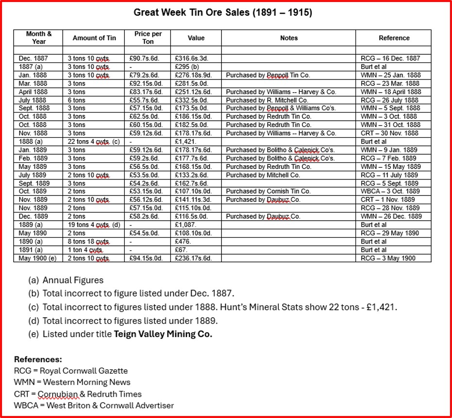
This annotated 19th century map shows the locations of the two beamworks and tors a short distance to the east of Chagford. The two locations are named on the tithe as Berra Plantation (1725) and Alder Park Plantation (2043). In Bowrie Beam, there are 3 or 4 gullies with one containing an impressive cliff faced tor which also had a wall structure built across its bottom. The beam originally crossed the road to where there is now a housing estateParts of Bowrie Beam in an area now known as Biera Plantation (or Berra Plantation in 1840). The beam is a in reality a collection of openworks and lie to the south of the Chagford – Westcott roadThe working run alongside a cliff-like tor, which is rather impressive. It is only a few hundred metres from the townThe author is unaware of a name associated with this tor. That said, it is recorded (outlined) on 19th century maps. The tor is approx 10m high by 50m wideThe tor is centred around SX70481 87598Across the beamwork next to the tor, a wall appears to have been constructed, which might well have been to contain waterClose up of the wall across the beamworkDartmoor Tinworking Research Group (DTRG) members in Bowrie BeamIf the tor were to have a name, the author would suggest either Berra Plantation Tor, Biera Wood Tor, Biera Tor or Bowrie Tor.Collage of Bowrie Beam photographsA short distance to the east of Bowrie Beam is another (un-named) BeamNear the north end of the beam is a large shaped rock (see foreground in the photograph). The rock has an iron hanger attached to one endThe iron hanger can just about be seen in this photograph. The rock is located at SX70664 87477A short distance into the beam from the rock with the iron hanger is a small torThe beam and tor are located in Alder Park Plantation (Tithe 2043). The plantation is split into 2 parts, with this part being the smallest (to the north of the largest part)The tor (or rocks) do not appear to have a name. If they were to receive a name then the most apt would most probably be Alder Park Rocks or Alder Park TorThe small tor (or rocks) are centred around SX70668 87453The bottom of Two Beamworks near Miners LaneFrom Miner’s Lane there is a well-trodden footpath which leads towards the beamworks, leats and shafts of Great Weeke Mine. The annotated 19th century map. The next part of this post explores these features. However, there are no remains of Great Weeke Mine dressing floor with it having been built upon.Ore sales for Great Weeke – information courtesy of Dartmoor Chris
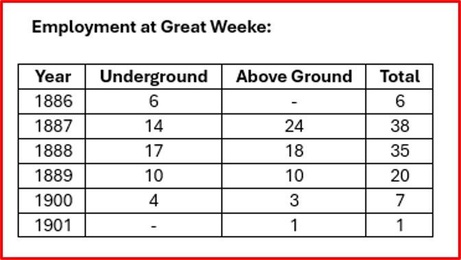
Employment at Great Weeke – information courtesy of Dartmoor Chris
Gatepost in Coombe Park en-route to the Great Weeke workings and mine. This gatepost is on the previously mentioned footpath.This slotted rock was found in Coombe Park, close to where the remain of an old leat can be found. The leat ran to Lydia’s shaft at the Great Weeke mine where there was a winding engine houseThe slotted rock is located at SX71096 87245One wonders if the slotted rock had any connection with the adjacent Great Weeke Mine leat.The leat can be traced through the woods in an approximate south-north lineThe leat runs above an early Beamwork (Openwork) near Great WeekeThis is a very impressive beamwork (openwork), which is 40-50ft deep and over 900ft in length. This openwork was part of the Great Weeke Mine and initially followed a north-west direction, then is intersected by a north-south lode.The beamwork (openwork) has a couple of old shafts contained therein.The leat continuing through the woodland and onto the 19th Century Winding Engine HouseLeat as it approaches another footpathTop of the Beamwork where it is intersected by the footpath. The footpath crosses the openwork and is near where a shaft called Lydia’s shaft is locatedOn the 1st March 1887 the Great Week Consols Tin Mining Company was registered with a share capital of £30,000 in £1 shares. The new company set to work in deepening the trial shaft (Lydia’s Shaft) erecting dressing floors, waterwheel, hoists and pump.Within the first year the shaft was sunk to depth of 28 fathoms (168 ft) and levels taken off east and west. Lydia’s shaft was once served by a tramway (hence the Winding Engine House) to the north-west to transfer ore down the hill and by flat-rods to the north-east for pumping. None of these features, except the shaft can be seen today unfortunately and appear to have been ploughed into the turf in the fields where they were once located. The photograph shows the probable point where the tramway joined up with the lane near Great Weeke FarmGreat Weeke FarmDouble Mortar embedded into a Barn wall at Great Weeke FarmClose up of the double mortar on Great Weeke Barn. The Great Week Consols Tin Mining Company in 1889 was reconstructed with an increased capital of 6000 shares (Broughton). The sett was increased from the original 210 acres to 700 acres. Shortly after, a further 6000 shares were made available to enable the company to reconstruct the dressing floors with the installation of steam-operated machinery. A 25” cylinder steam engine was also sited at Lydia’s Shaft to effect winding and a tramway was constructed from the shaft to a loading bay at Kenslade Lane (Broughton). Despite such developments, tin production began to fall and by the end of 1890 the labour force was down to seven men. By now the lower levels were flooded and the four men underground were working out old stopes in the adit level. The mine was eventually abandoned in 1892, having produced a recorded total of 56 tons of tin concentrate, realising £3367.In March 1896, the Teign Valley Mining Company was formed with a capital of £20,000 in the form of 80,000 shares. Of these 79,800 shares were issued to the vendors. Another 79, 800 shares were issued for the purchase of the mine, the purchase consideration being £13,965, with 3s 6d per share as paid (Broughton). The mine was drained, timber work and machinery repaired and for the next two years the adit and 12 fathom level were driven further west. The amount of ore raised if any, is unknown, however in 1901 the company was reconstructed as the New Teign Valley Mining Company with a capital of £15000. This scheme of reconstruction provided for the issue of four new 5s shares, each credited with 4s paid, in exchange for each old fully paid 5s share (Broughton). However little work was undertaken in the next two years and in 1903 by order of the County Court, the plant and machinery belonging to the company was put up for auction. This included two steam engines, winding gear, pump rods and poppets, 24 heads of stamps, two waterwheels and various mine fittings (Broughton). There is some conflicting information concerning this last period of the mines history as Hamilton Jenkins states that the last working took place in 1904, when a small steam engine was erected for hoisting on Lydia’s Shaft. The waterwheel and flat rods were still the means for pumping the mine, while the dressing floors consisted of 6 head of stamps, shaking tables and buddles, with the final concentration being obtained by tossing and packing in kieves(Possible) Apple Crusher at Great Weeke Farm. Inside the barn at Great Weeke reveals a splendid granite construction which was a bakehouseA 40 ft waterwheel situated at the dressing floor operated the pumps by a series of flat rods, as well as 12 head of stamps. The dressing floor included two round buddles, three ‘working buddles’ and finishing floors with a spare buddle. The mine employed thirty eight men, fourteen underground and twenty four on the surface. Lydia’s shaft reached a depth of 36 fathoms, (216 ft, 24 fathoms below adit) and drives being made east and west on the 12 and 24 fathom levels. The picture is taken from the lane by Great Weeke Farm and shows the probable line of the flat rodsMine Captains House in Tarr Lane. Either side of this lane (although not visited) are some more shallow openworks. In this area there were once three more lodes previously worked by the ancients and were named as Tucker’s, Leach’s and George’s (Broughton).North west of Rushford Bridge across the River Teign there are some previously unrecorded openworks (beamworks) around the woodland where on modern OS maps Rushford Tower is marked.Openworks near Lower WithecombeMore openworksSmall clapper in the dense undergrowth at SX70087 88877More openworks near Rushford TowerMore openworksMore openworksMore openworksWalling – the purpose is not clear as it doesn’t appear to be for a field systemMystery metal work – probably farm relatedContextual picture of the metalworkMystery Building at SX70210 88676. Picture by courtesy of Matt Johnson


Murray February 17, 2025
The huge stone fireplace & chimney were part of a Bakehouse.
Listed here (the slightly curved granite arch is described simply as a ” massive granite lintel”):
https://historicengland.org.uk/listing/the-list/list-entry/1308693?section=official-list-entry
SteveGriggDartmoor August 23, 2025 — Post author
Hi Murray,
Many thanks for this additional information.
Kind Regards,
Steve