A collection of walks, discoveries, insights and pictures of exploring Dartmoor National Park
April 29, 2021
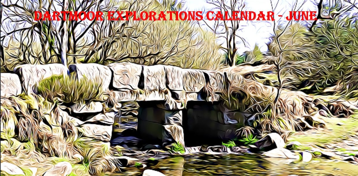
DARTMOOR EXPLORATIONS CALENDAR – JUNE
In 1991, the Dartmoor National Park Authority (DNPA) published a spiral bound diary to commemorate their fortieth anniversary (1951-1991), called “The Dartmoor Diary”.
Inspired by this publication (and some of the entries in it) and to celebrate the DNPA 70th anniversary year in 2021, the “Dartmoor Explorations Calendar” records an event or story, complemented with photographs for each day of the year.
This page of the Dartmoor Explorations Calendar celebrates June on Dartmoor and its immediate borderlands.
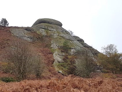
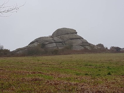
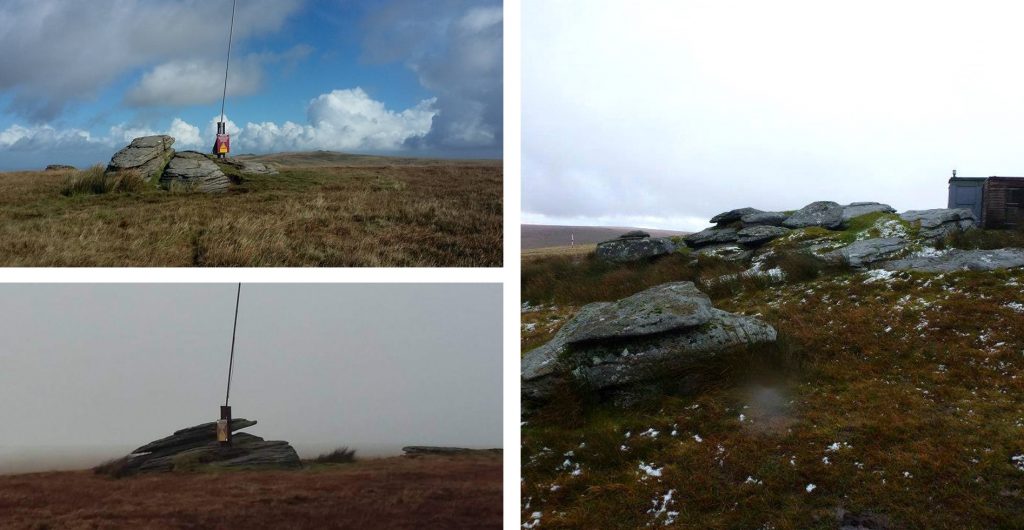
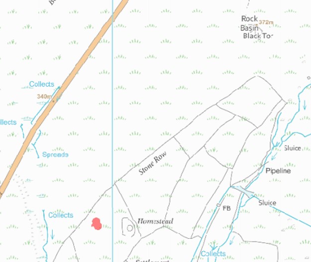
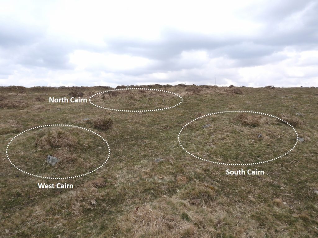
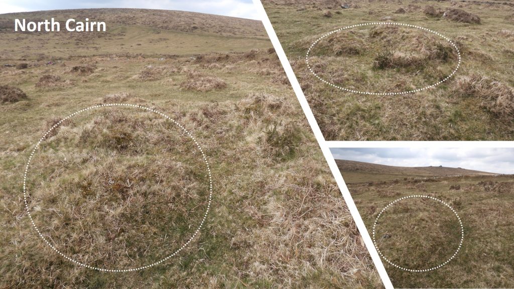
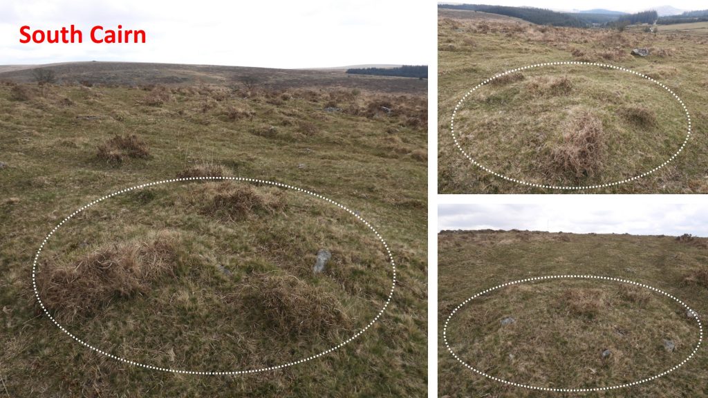
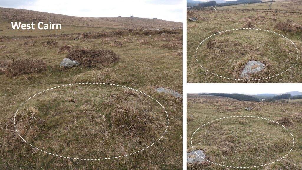
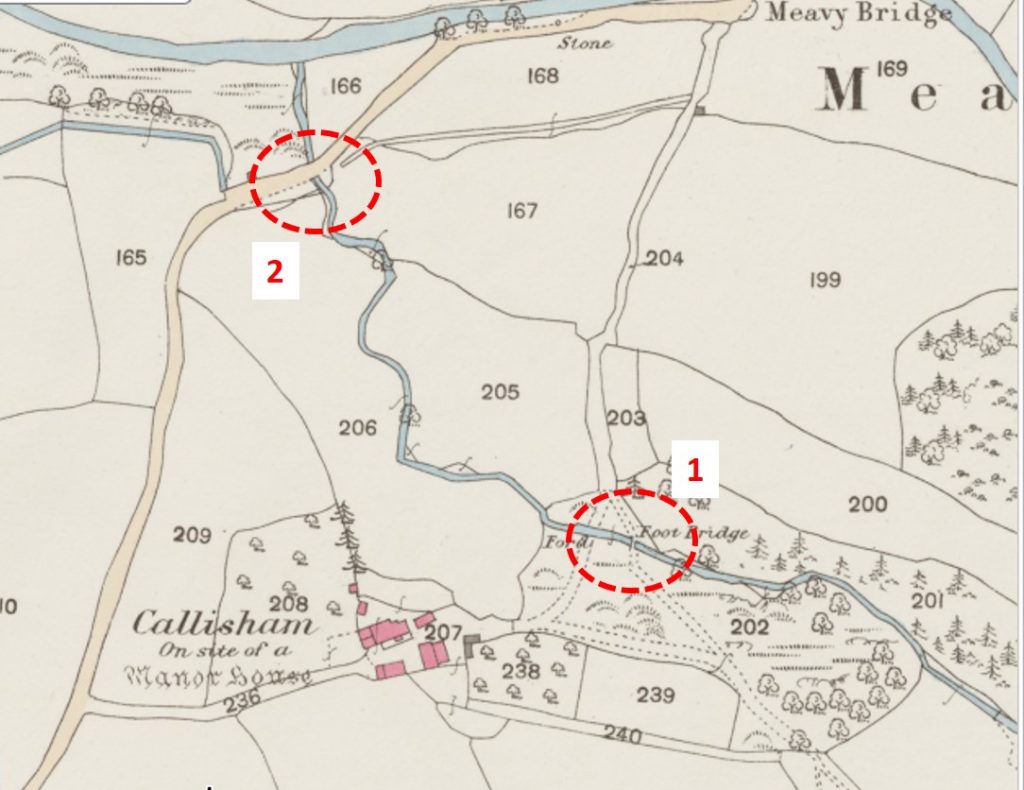
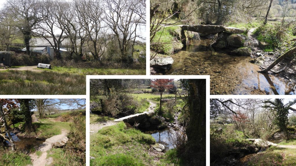
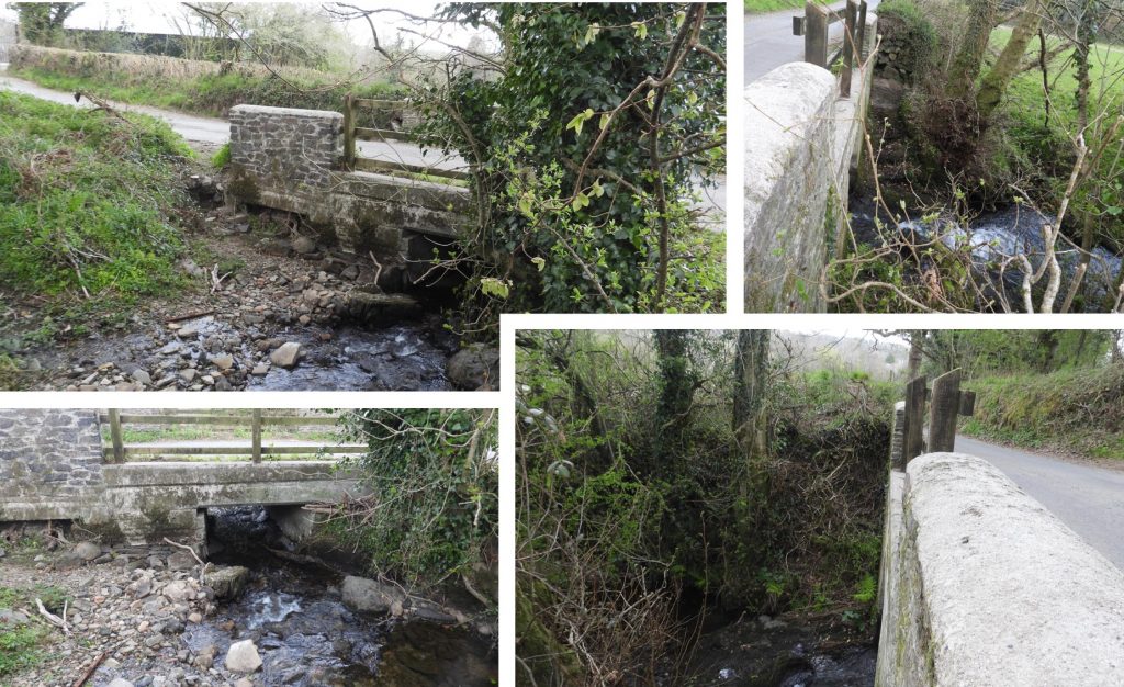
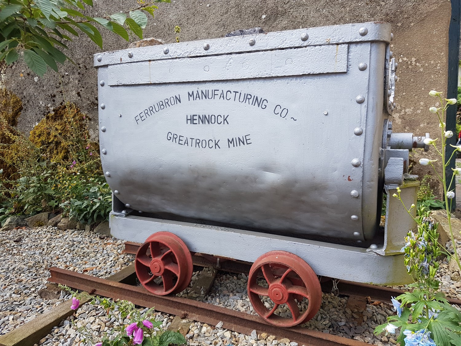
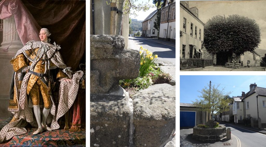
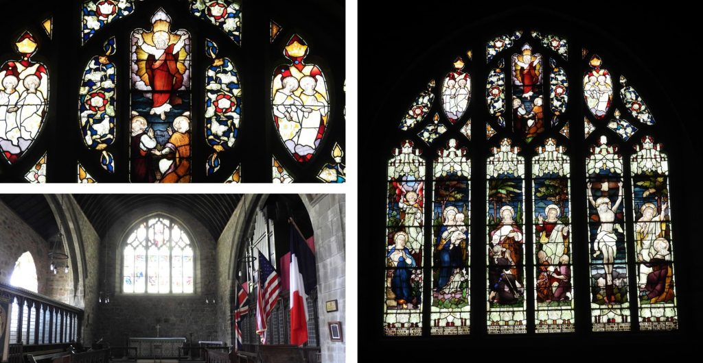
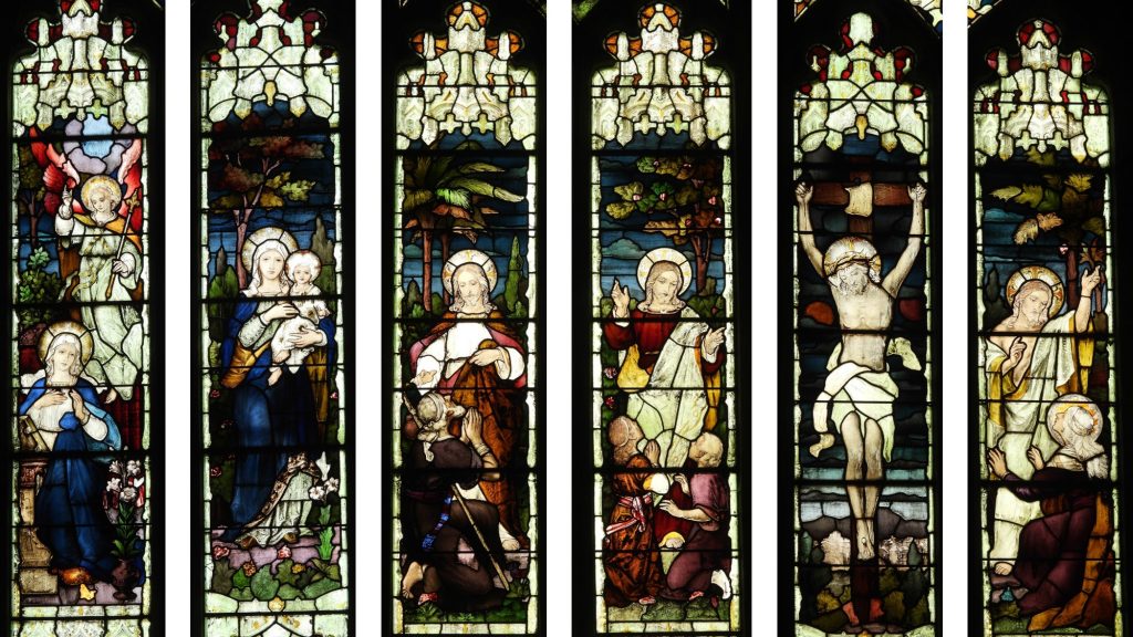
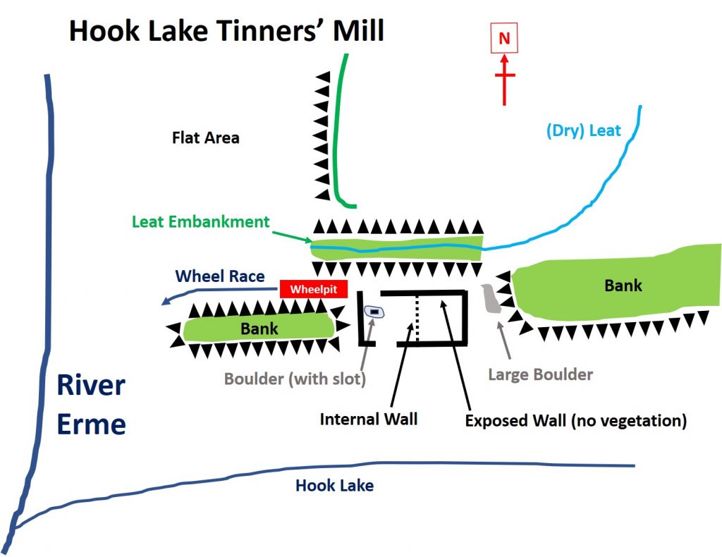
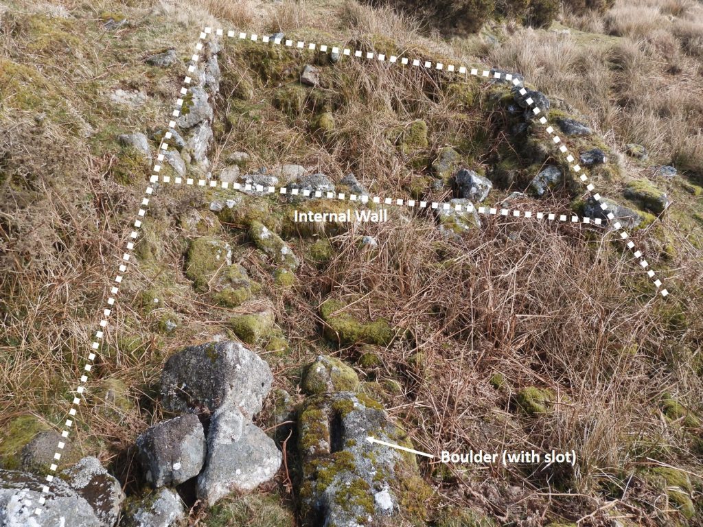
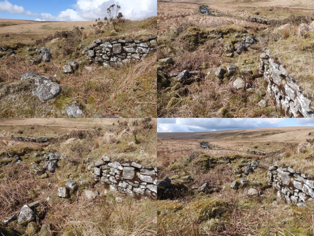
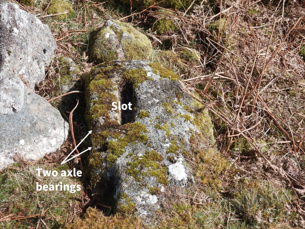
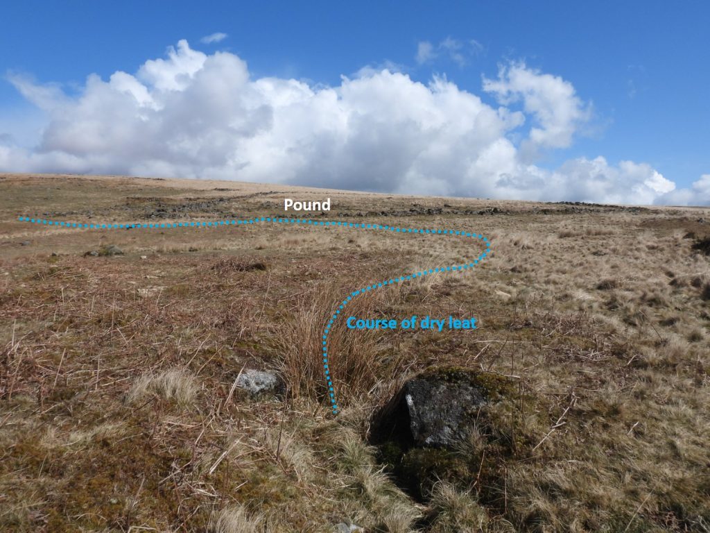
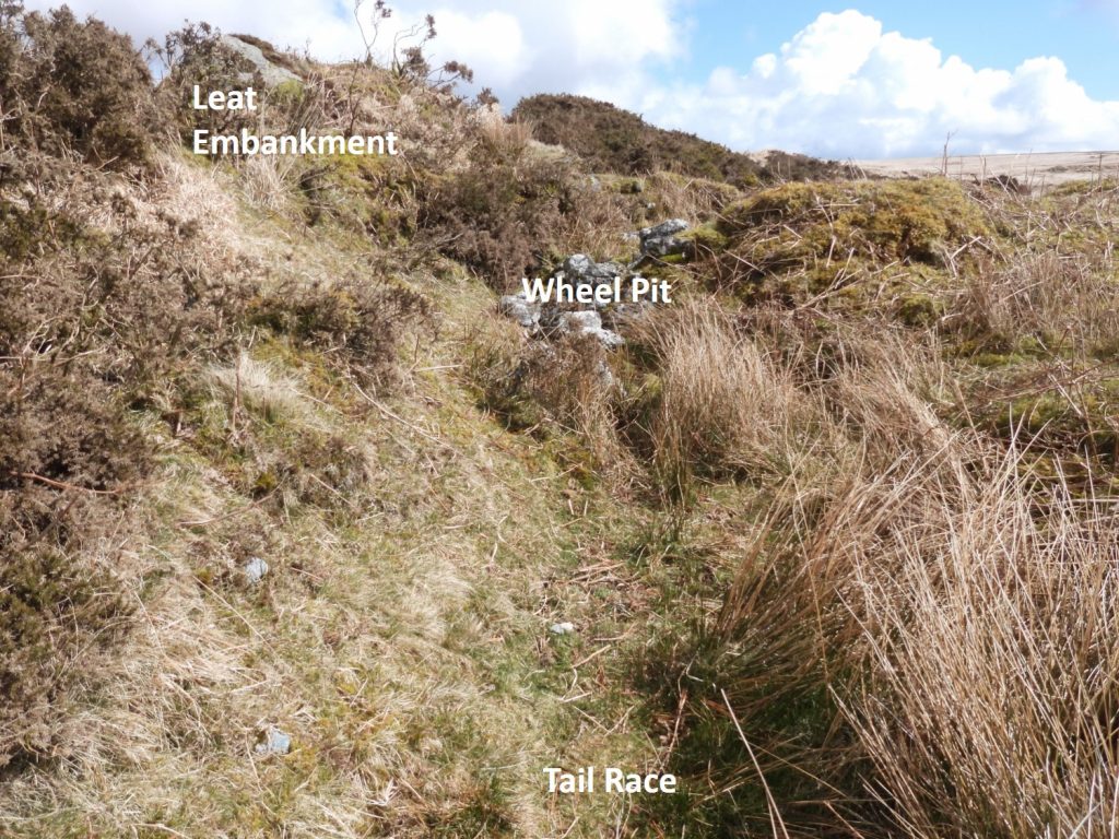
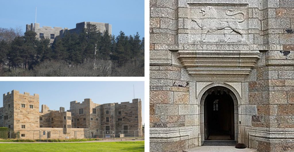
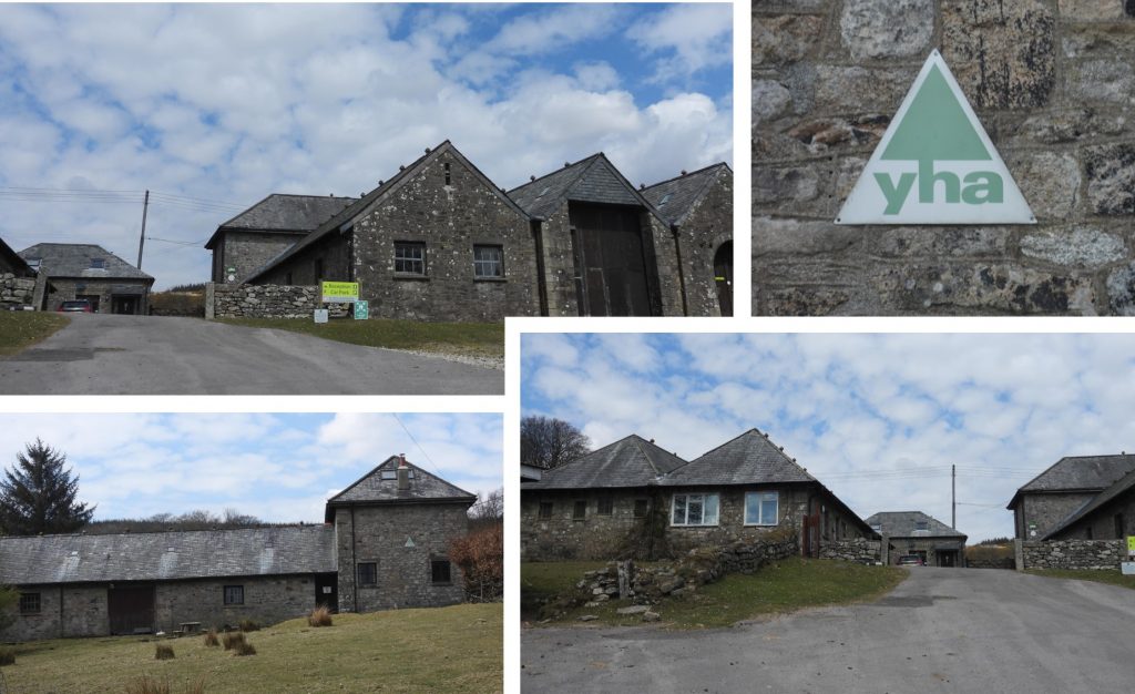
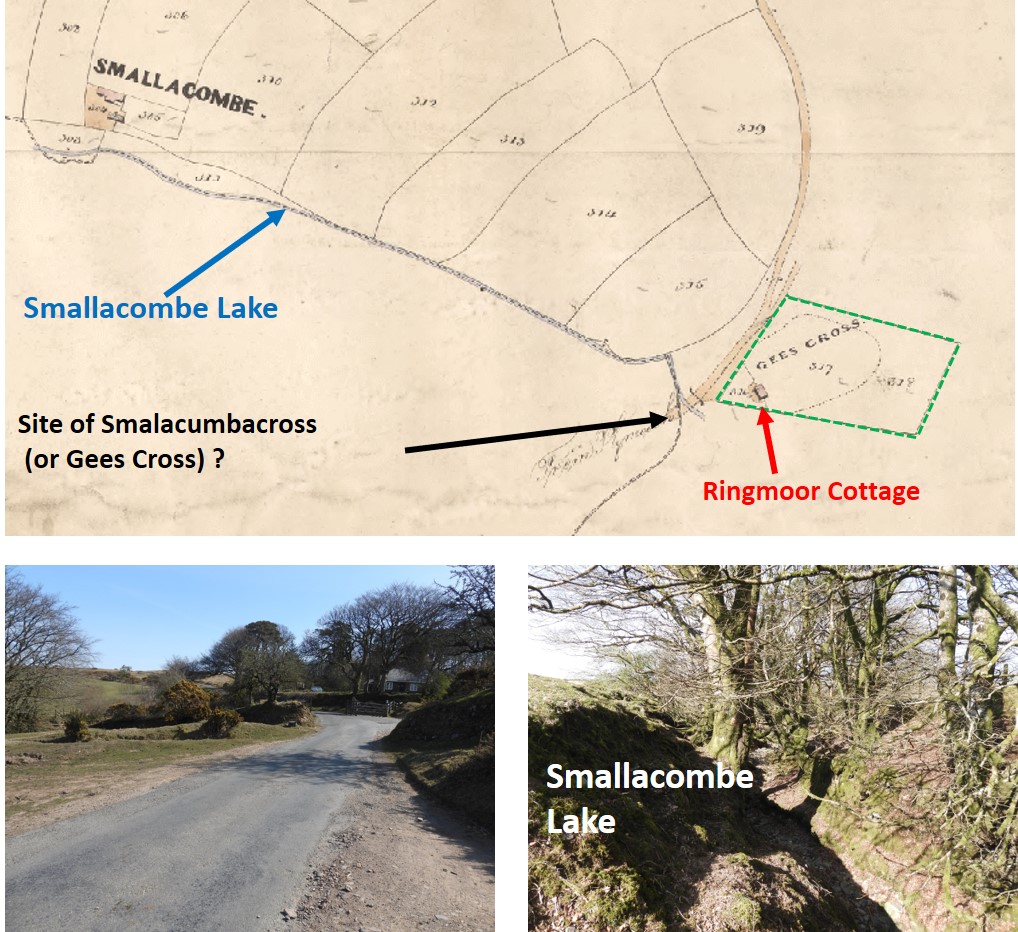
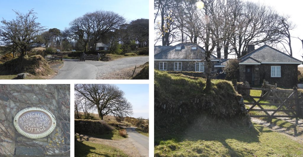
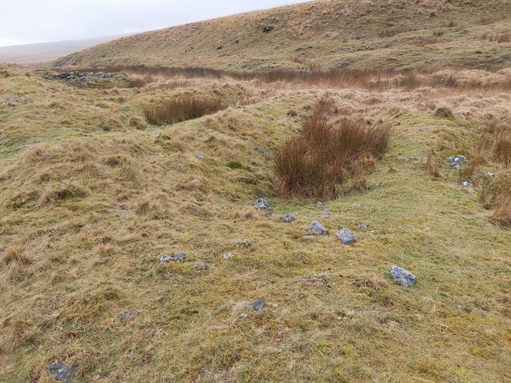
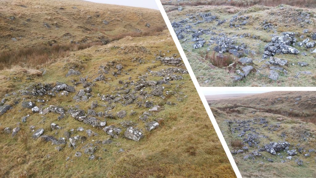
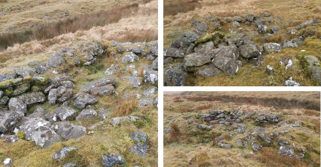
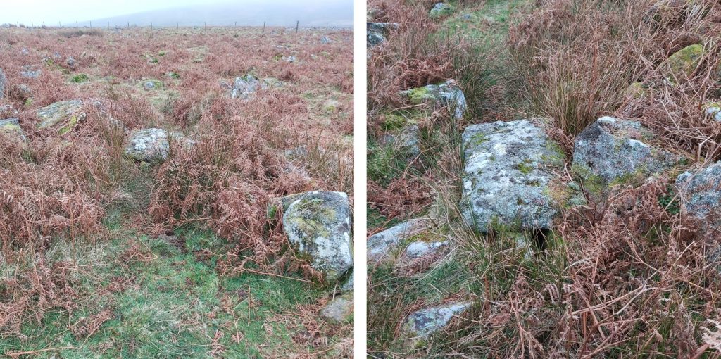
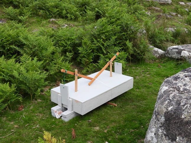
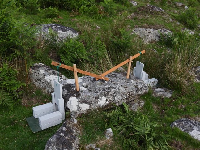
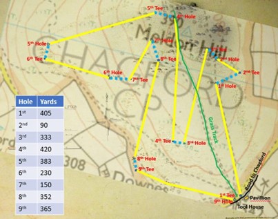
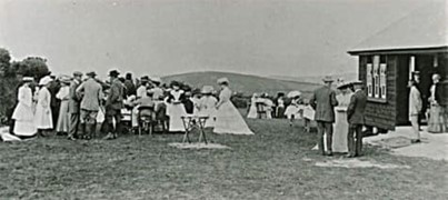
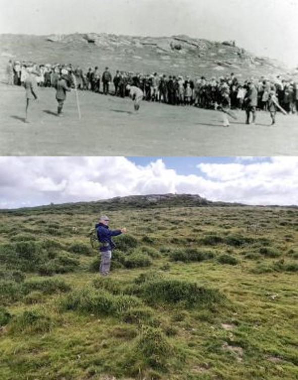
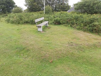
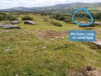
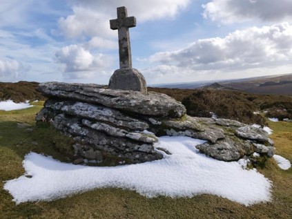
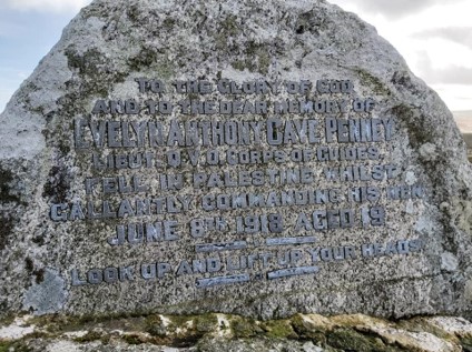
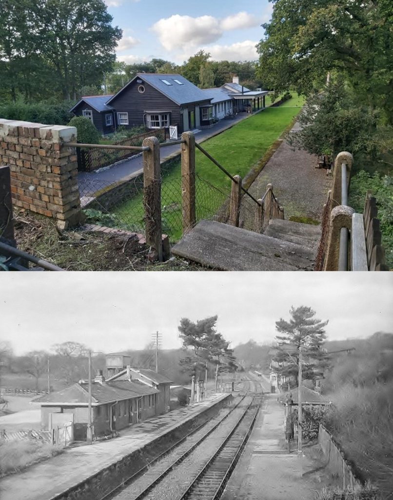
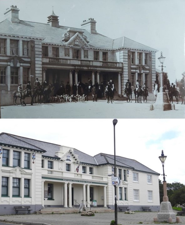
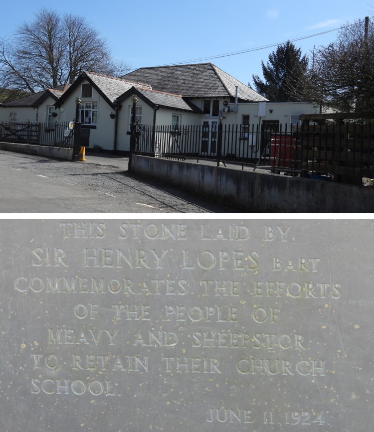
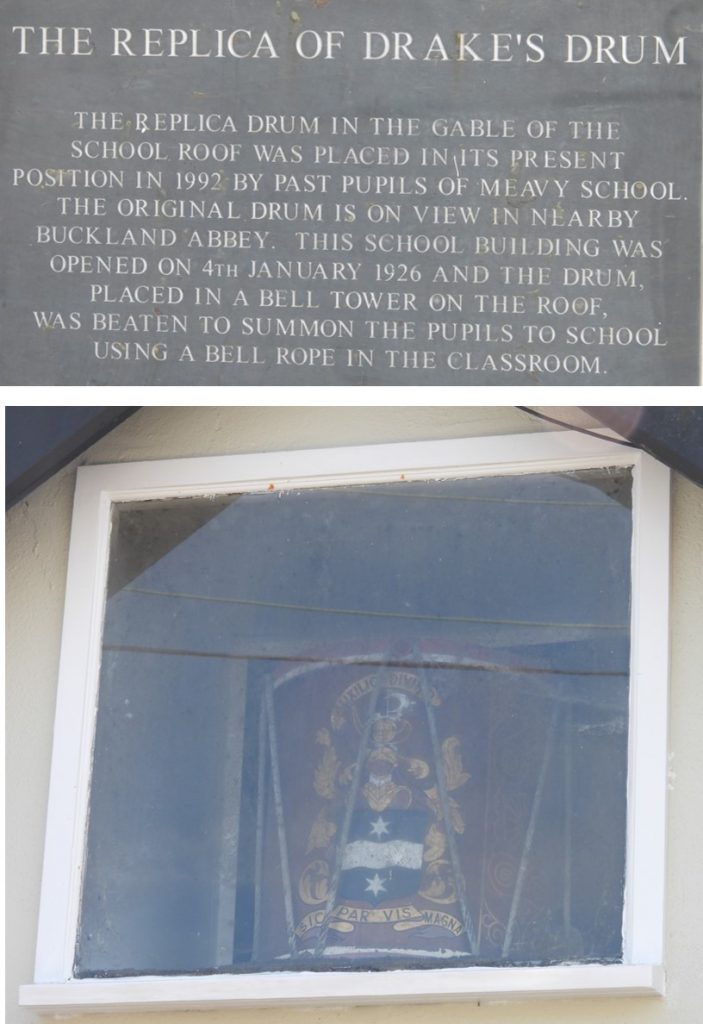
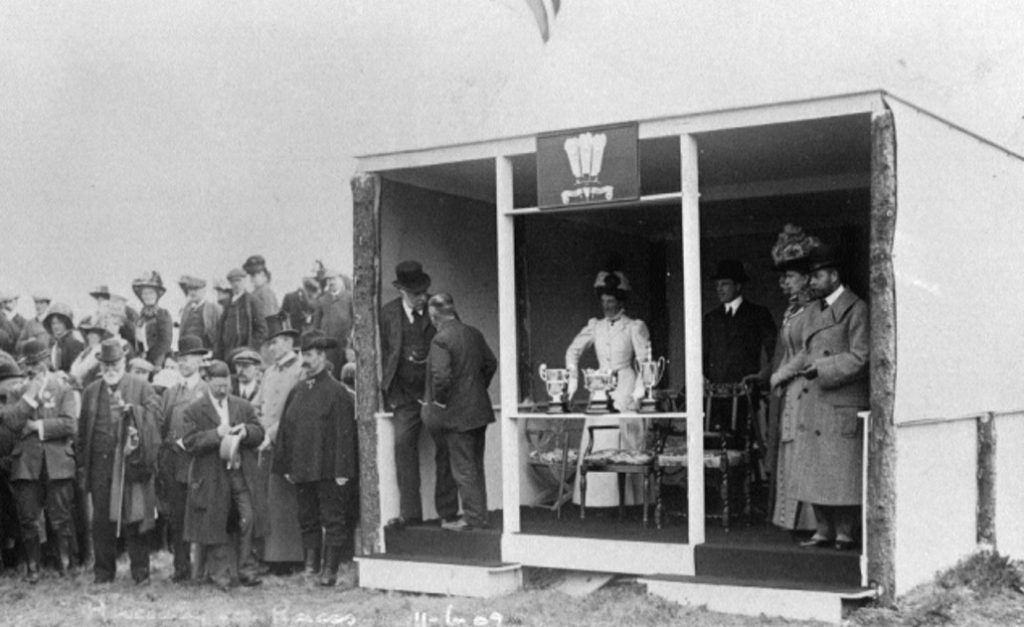
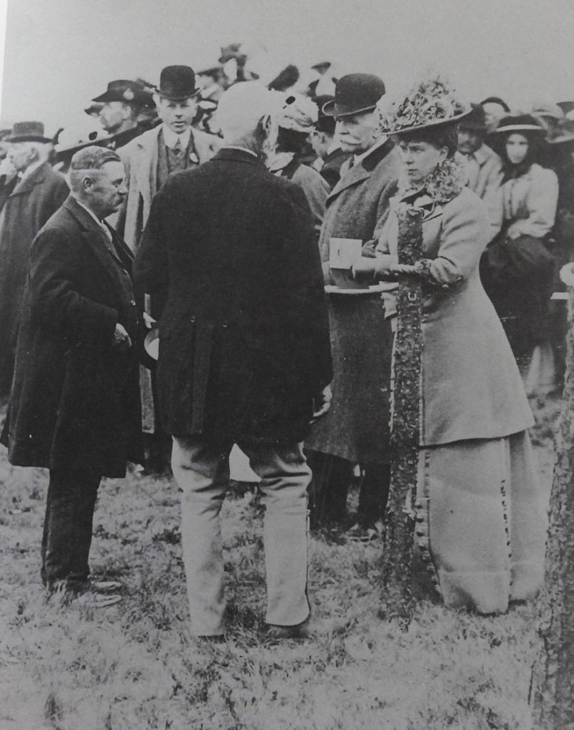
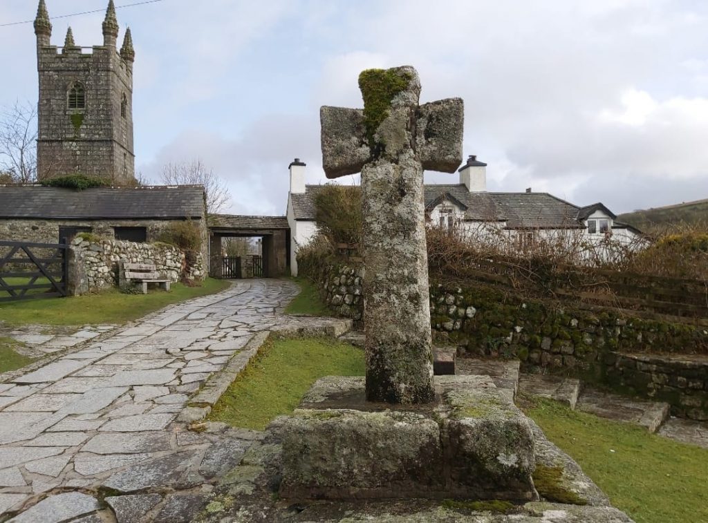
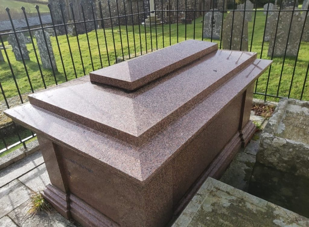
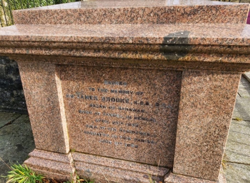
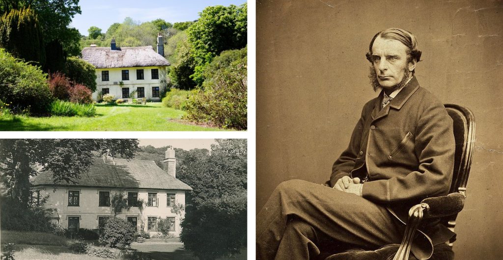
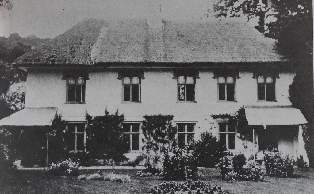
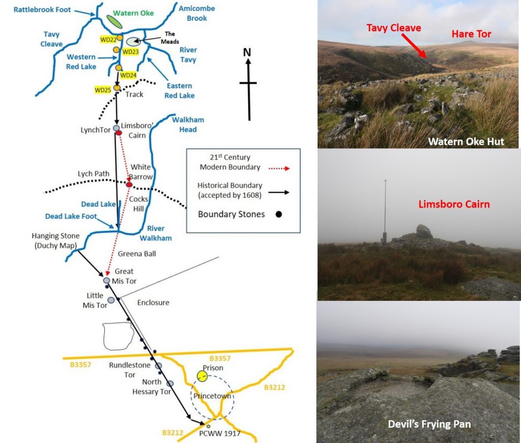
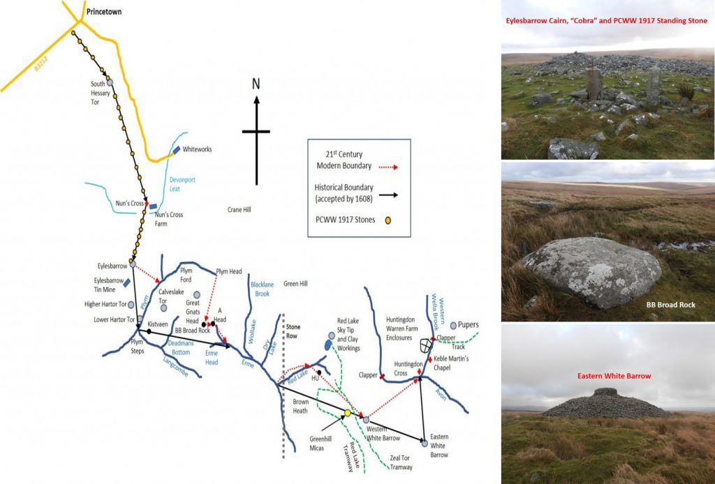
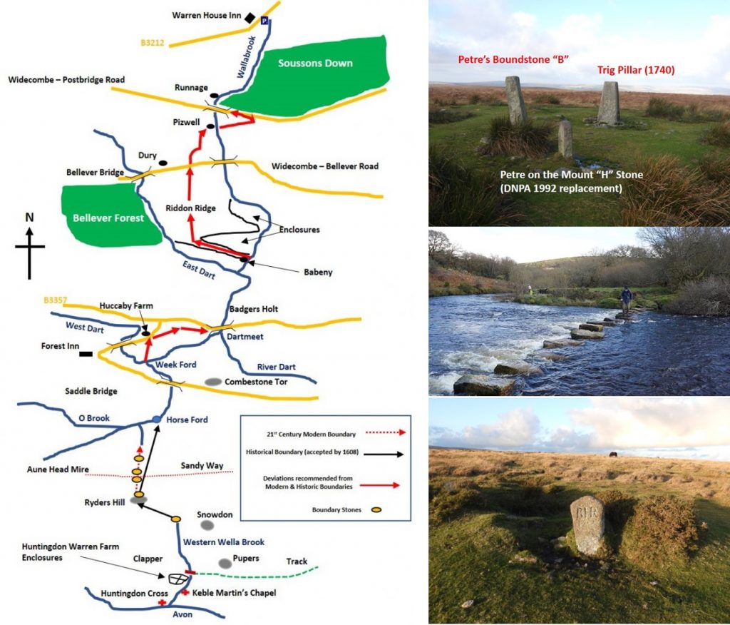
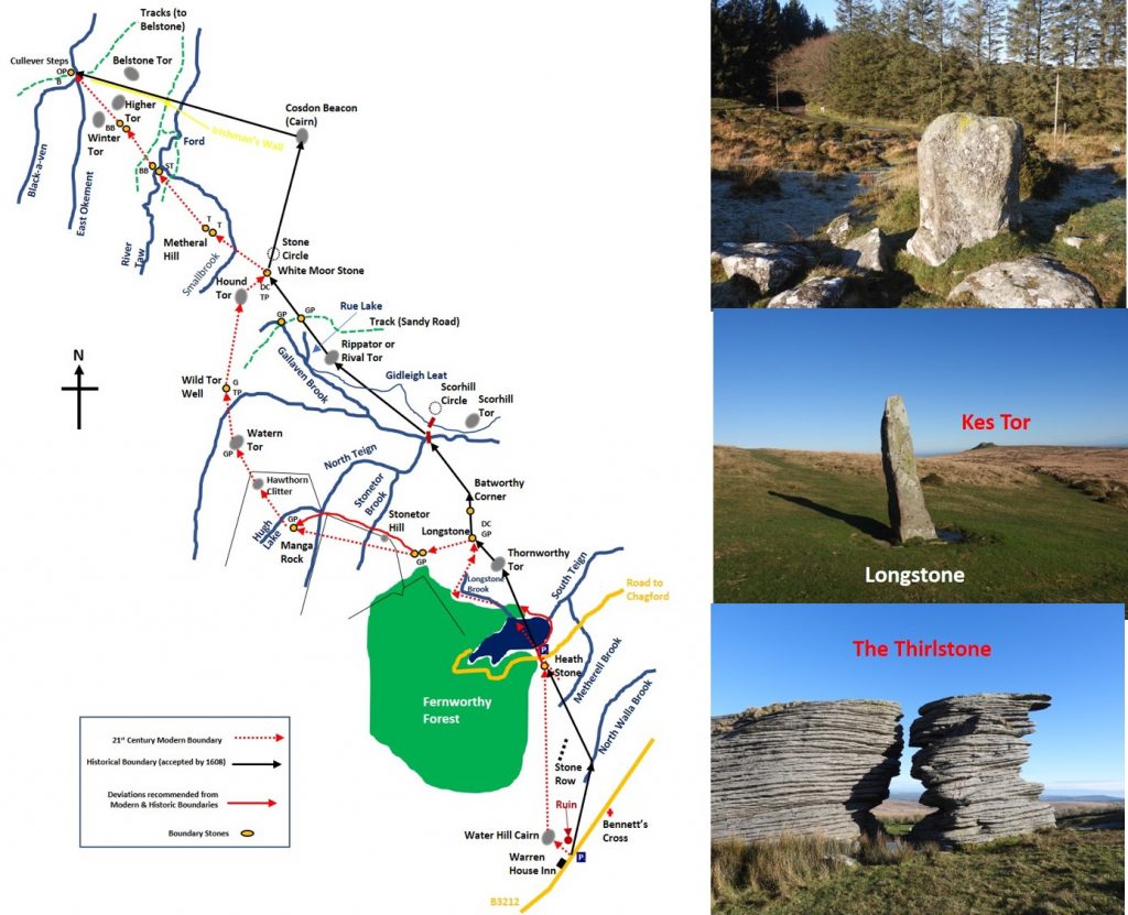
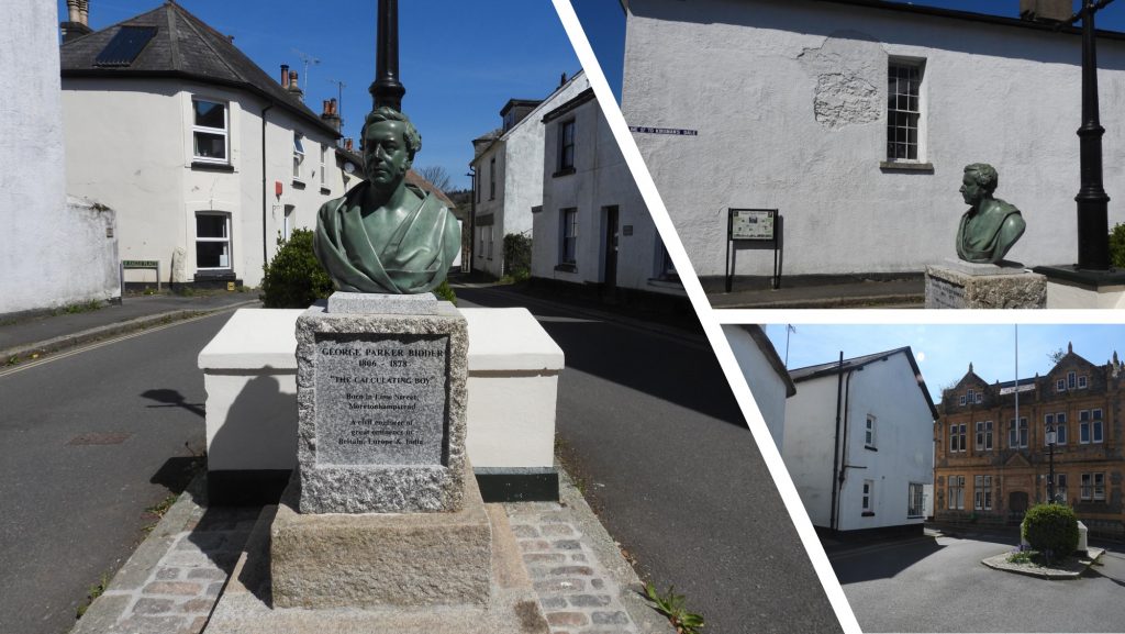
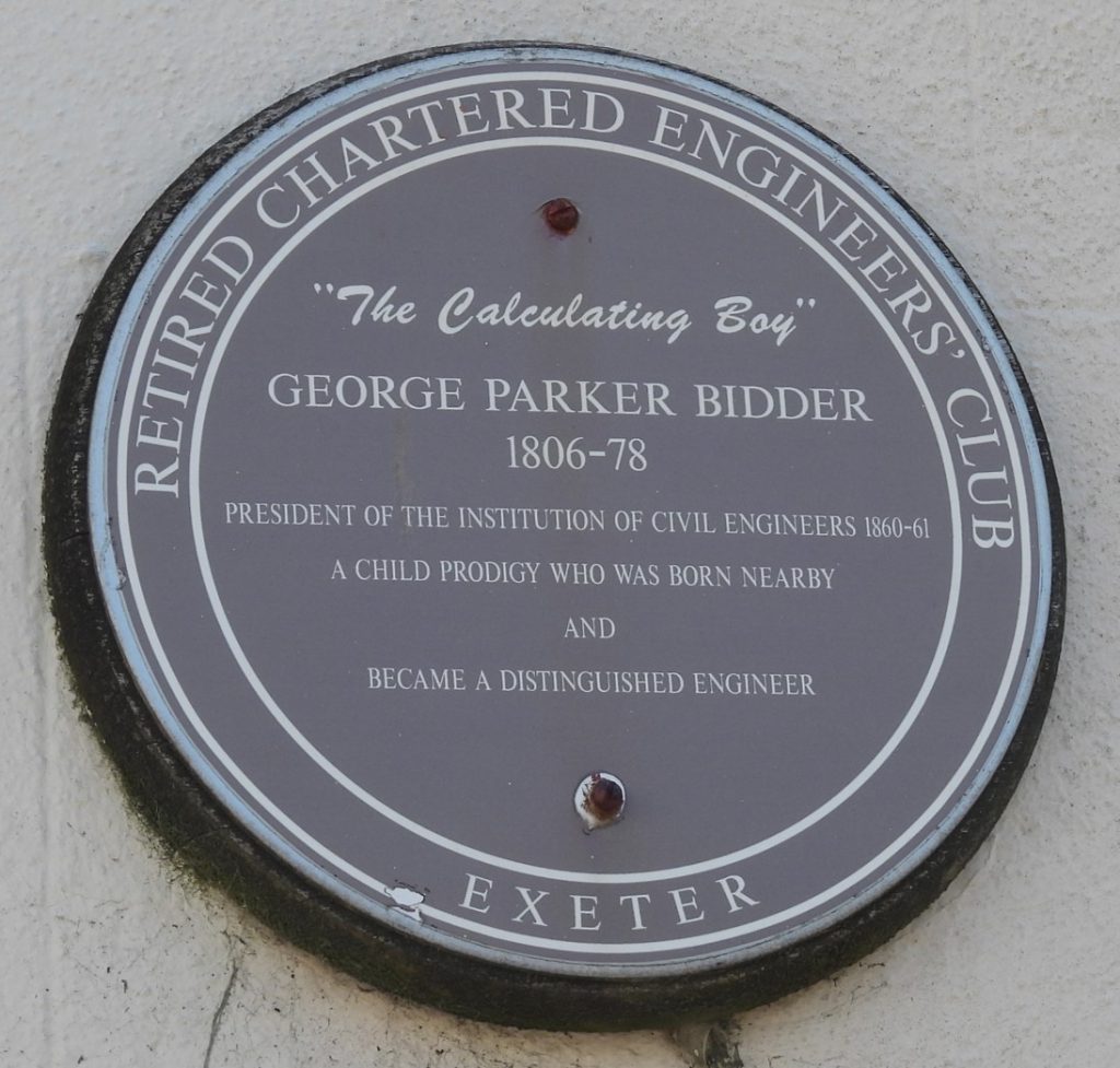
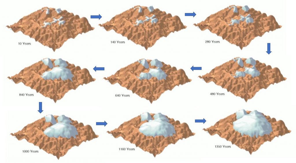
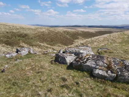
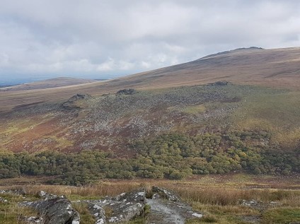
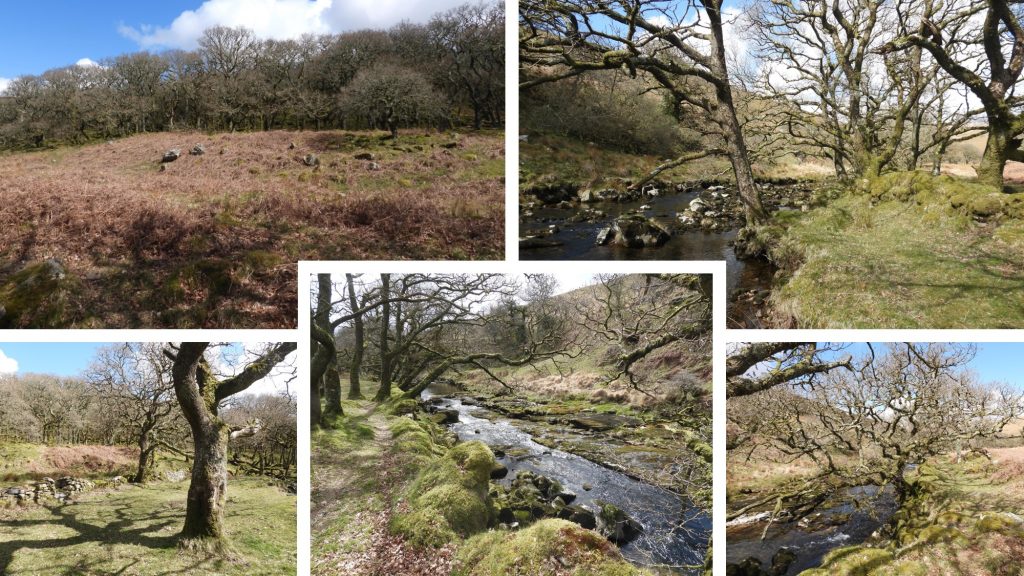
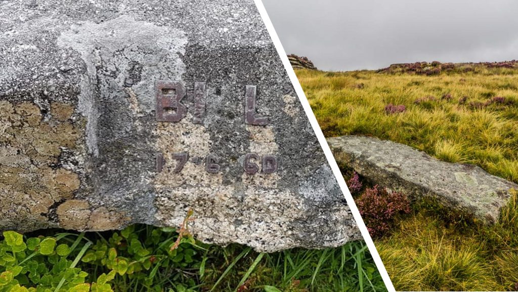
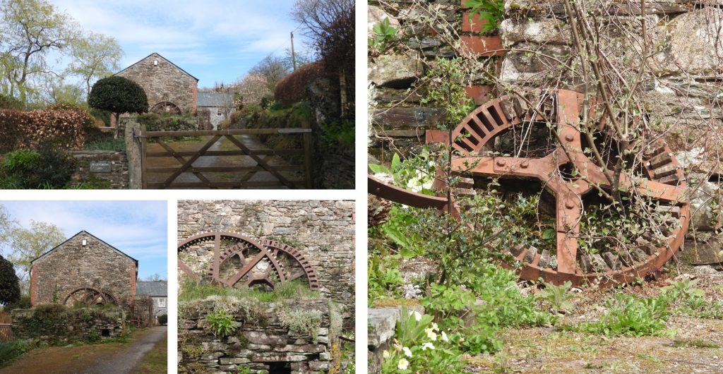
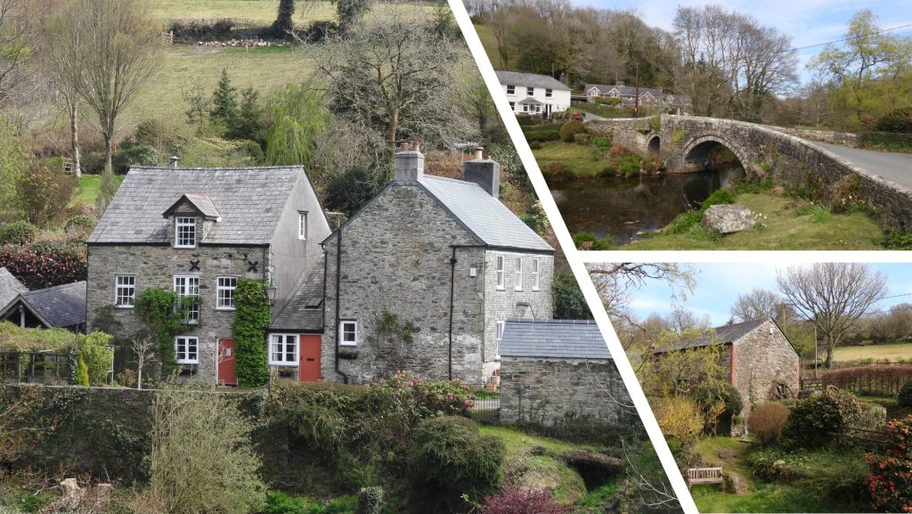
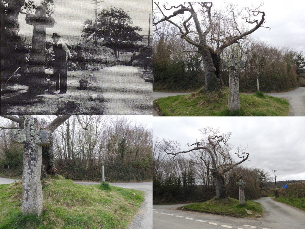
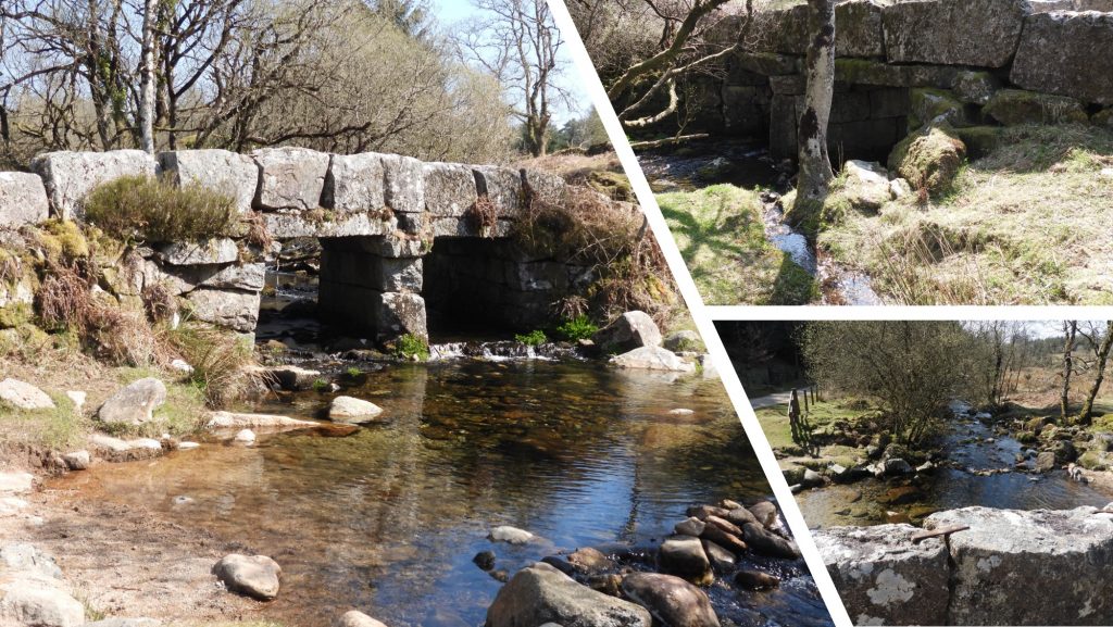
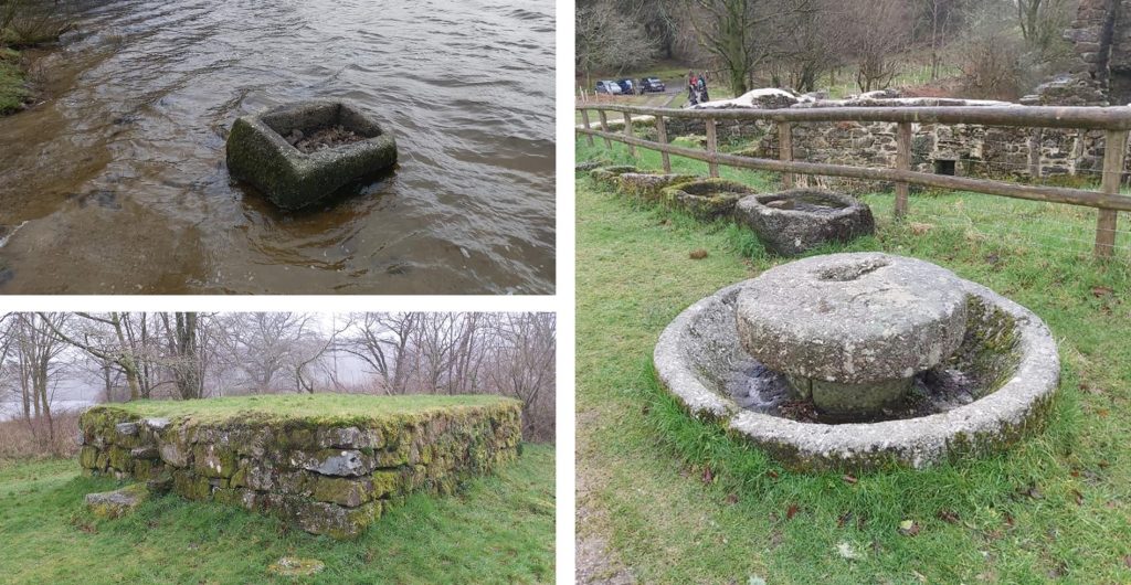
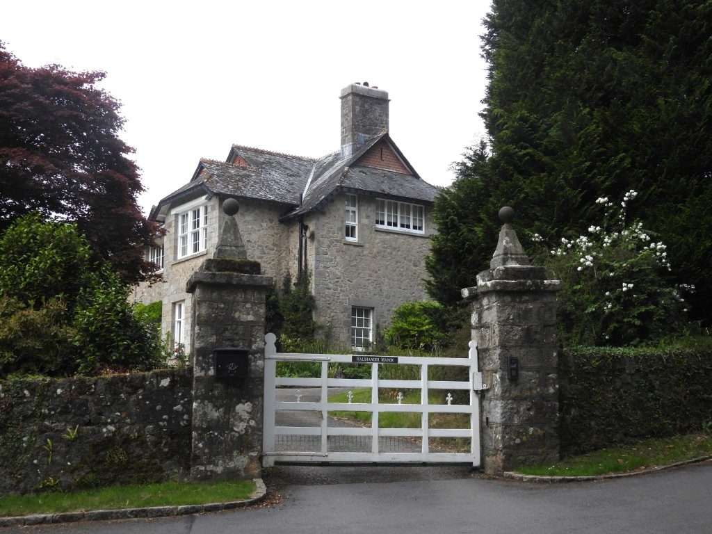
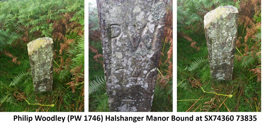
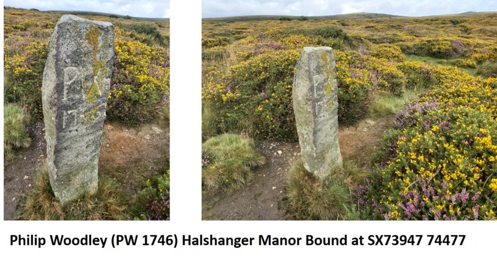
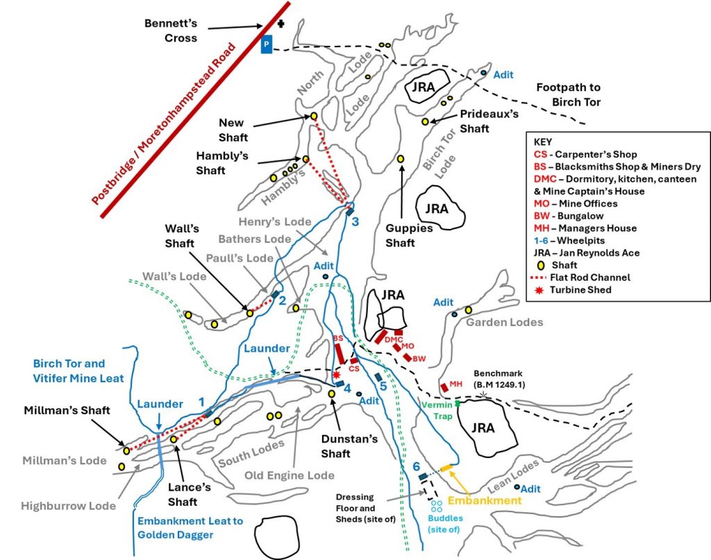
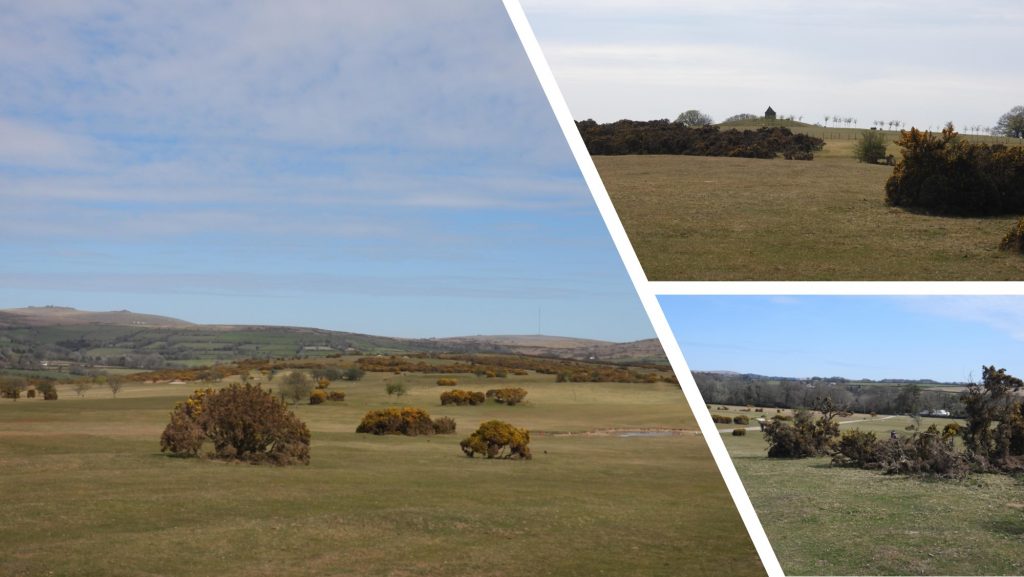
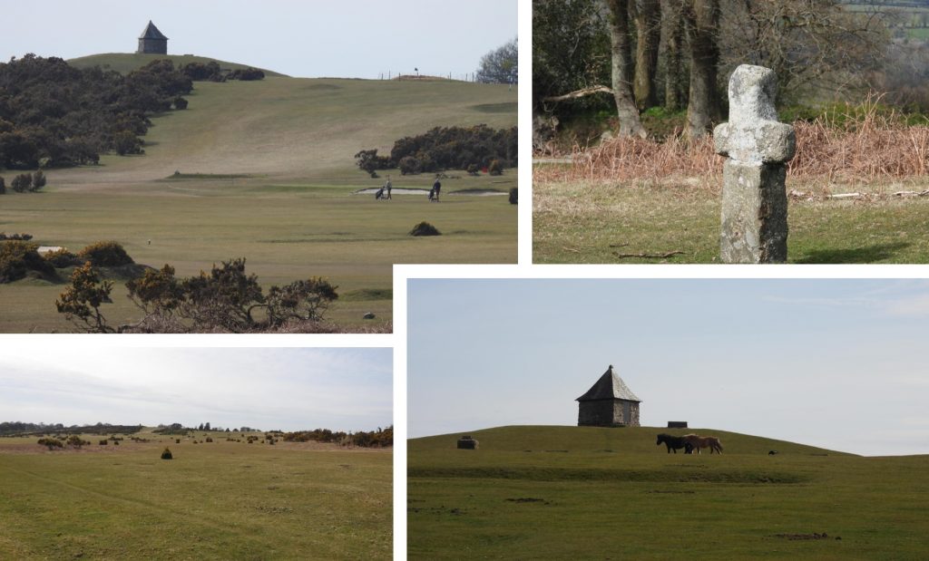
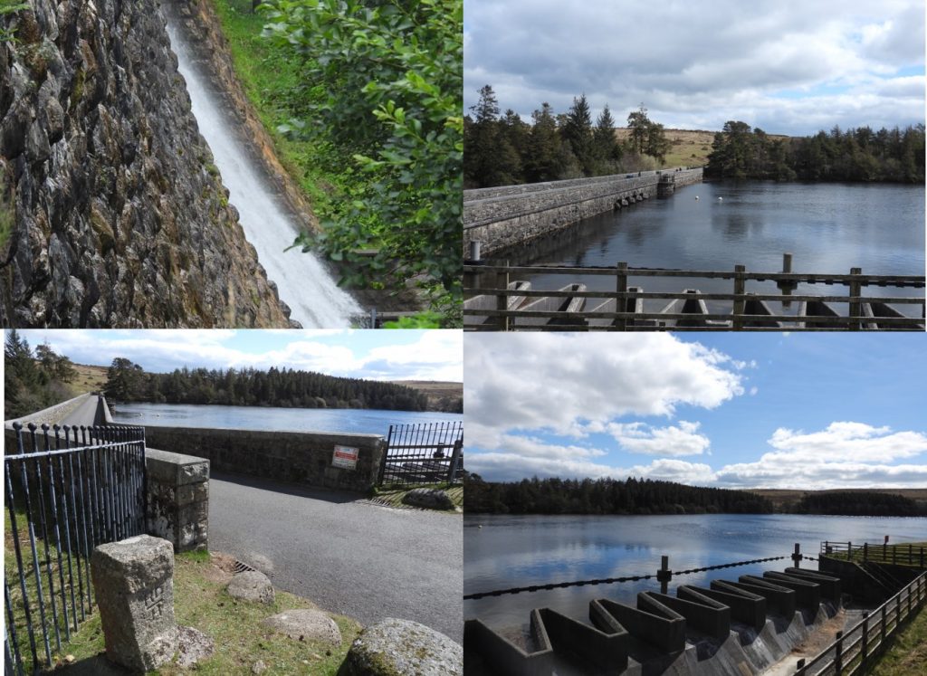
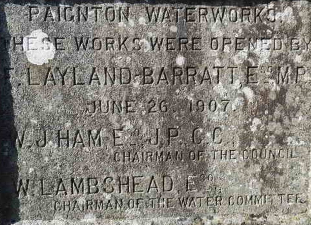
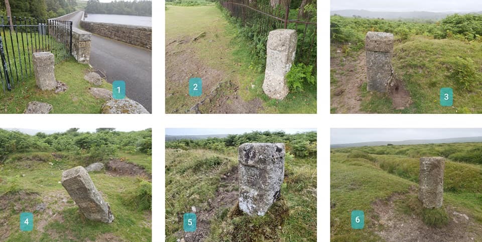
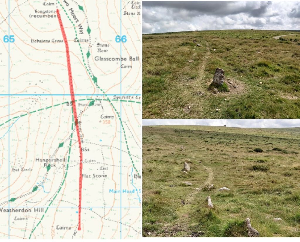
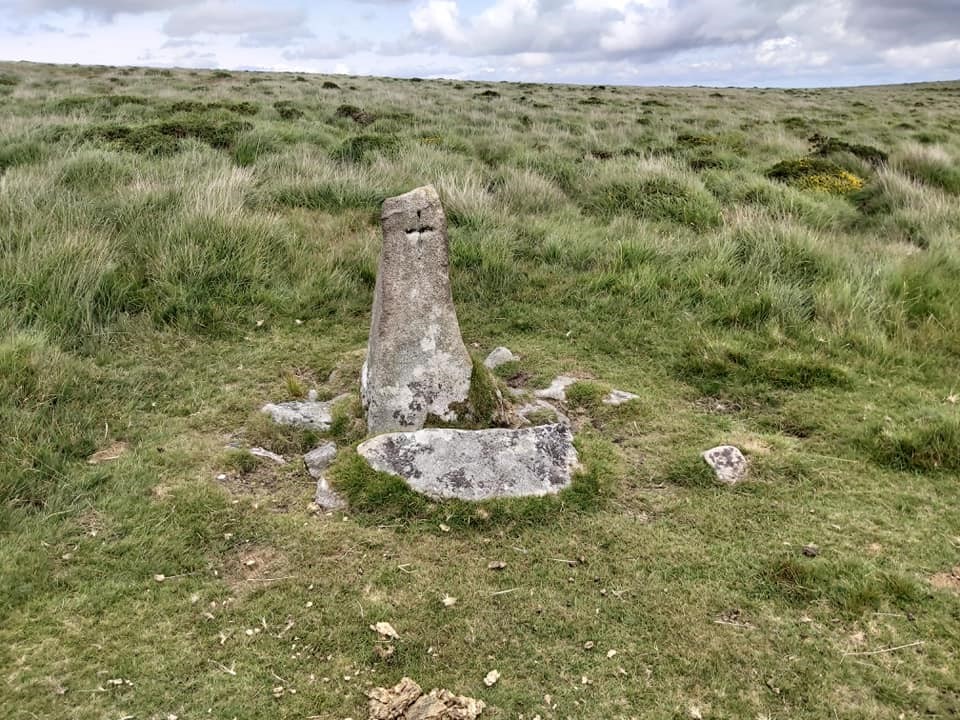
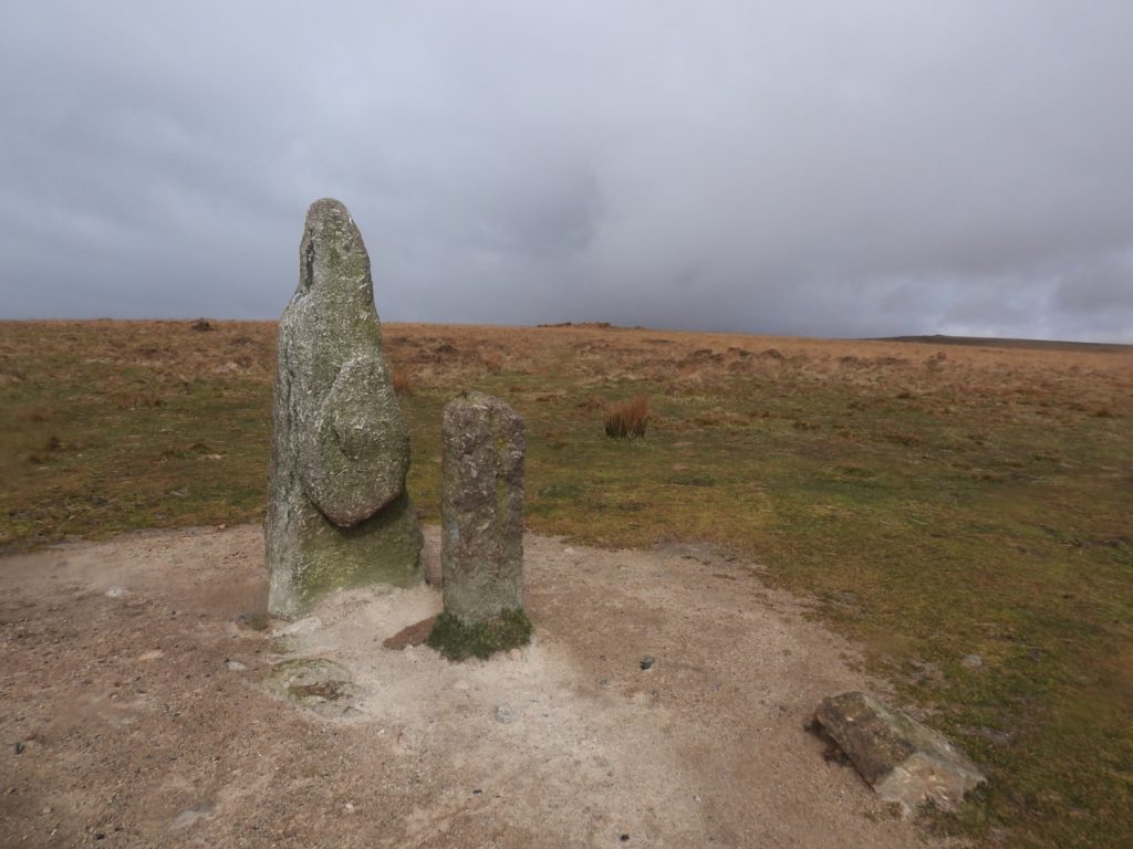
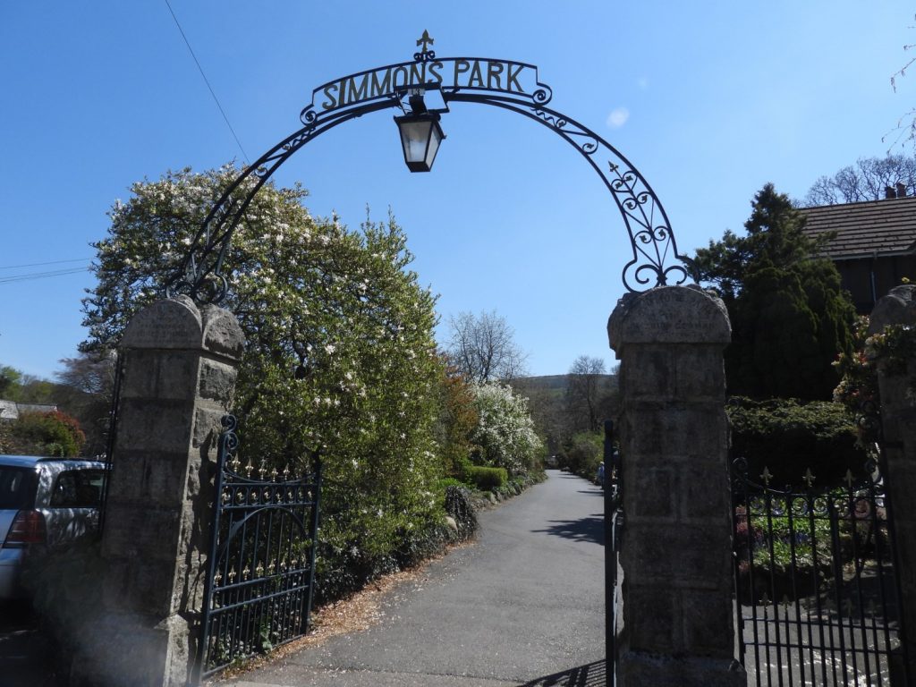
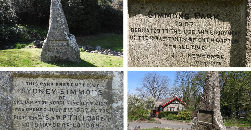
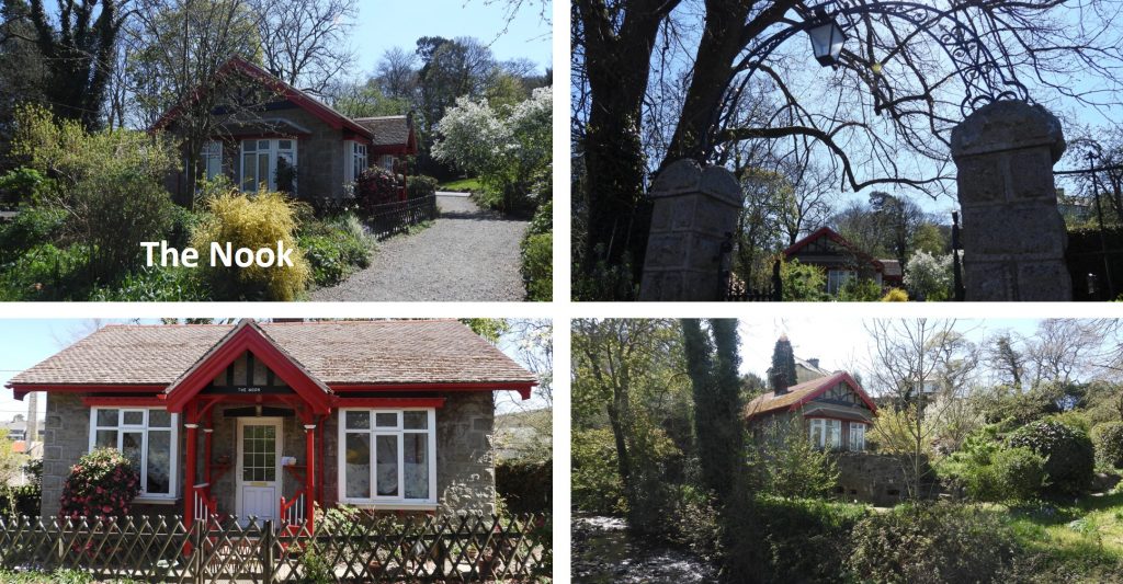
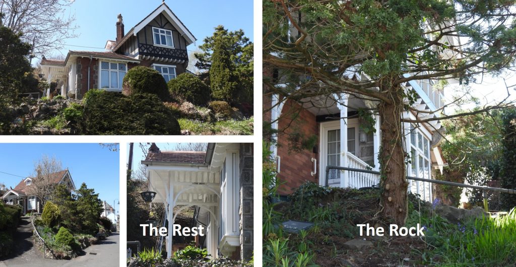
1st June 1981: Blackingstone Rock was purchased by the National Park Authority to safeguard the tor’s landscape setting and to secure public access. Picture taken from the north side of the tor.1st June 1981: Blackingstone Rock was purchased by the National Park Authority to safeguard the tor’s landscape setting and to secure public access. Picture taken from the south side of the tor.1st June 1943: A Vickers Wellington GR11 MP597 from 3 overseas delivery unit RAF, struck the ground at Kitty Tor in poor visibility during a ferry flight to Gibraltar. Of the crew of 5, 1 was killed and 4 were injured. Source: Dartmoor Air Crashes (Aircraft lost in WW2) by Robert Jones.2nd June 1994: Three round cairns 610m south west of Black Tor, were registered on Historic England database. Registration 1011169.2nd June 1994: Three round cairns 610m south west of Black Tor, were registered on Historic England database. Registration 1011169. These are not the most discernible of cairns on Dartmoor and any visitor would be wise to take a copy of the description of each cairn, which can be found on the Historic England website.2nd June 1994: Three round cairns 610m south west of Black Tor, were registered on Historic England database. Description from the Historic England website: “The northern cairn mound measures 7.5m in diameter and stands up to 0.7m high. A few retaining stones are visible around the perimeter of the mound, indicating the presence of a kerb which survives largely as a buried feature. A slight hollow in the centre of the mound suggests partial early excavation or robbing”. The northern cairn is at SX56955 712992nd June 1994: Three round cairns 610m south west of Black Tor, were registered on Historic England database. Description from the Historic England website: “The southern cairn mound measures 4.7m in diameter and stands up to 0.7m high. A few stones set on edge around the western perimeter of this mound suggest that it too contains a kerb”. The southern cairn is at SX56958 712922nd June 1994: Three round cairns 610m south west of Black Tor, were registered on Historic England database. Description from the Historic England website: “The western mound lies 2m from the southern one and measures 3m in diameter and stands up to 0.5m high”. The western cairn is at SX65951 71290.3rd June 1839: Callisham Ford and footbridge. On this date the following entry, appears in the Maristow estate stewards’ accounts — “Pd John Pedler your Subscription towards erecting a Bridge over the Callisham Brook, Meavy £1 10s” — the “your” referring to Sir Ralph Lopes, then lord of the manor……..but to which bridge does this entry refer ? Source: Mike Brown CD – Guide to Dartmoor3rd June 1839: Callisham Ford and footbridge. The entry in the Maristow estate stewards’ accounts probably does not refer to the little bridge (number 1 on the map), or its predecessor, for which just a few suitably proportioned slabs of granite would have been required, costing only a few shillings. The pictures show this footbridge and Callisham Farm.3rd June 1839: Callisham Ford and footbridge. The entry in the Maristow estate stewards’ accounts probably refers to the road bridge (number 2 on the map), or certainly a predecessor.3rd June 1812: On this date a lease was granted to John Gullet enabling him the “full and free liberty, licence and authority to dig, work, open, mine and stream and search for tin, tin ore, copper ore, all other minerals and metals whatsoever in the Parish of Hennock”. He was also given permission “within the limits of the set….to dig, make and work such adits, shafts, pits, drifts, leats or watercourses, and to errect (sic) necessary houses, sheds, engines, stamping mills and other buildings and conveniences as necessary”. Source: The Dartmoor Diary 1991 by DNP. This lease was, of course, a pre-cursor to Devon’s last metal mine, Great Rock, whose main period of operation was from 1900 through to 1969.4th June 1800: On George III’s birthday loyalty in Mortonhampstead was shown with a concert to mark the occasion at the Cross Tree. The Cross Tree was also once known as the Punchbowl Tree and was a pollarded elm whose branches were at one time trained into the shape of a punch bowl (see black and white image). The tree has a history going back at least to 1790, when it reputed to have already been big enough to hold tables and chairs. It grew through the base of what may well have been a very old cross to the south of the church, giving its name to Cross Street. Today the tree there is a much less grand affair.4th June 1910: The National Society of the United States Daughters of 1812 presented the East window of St Michael and All Angels as a memorial to the 271 prisoners of war who had died at the prison (Source: Pamphlet from the church). This is the only church in England with such an attribute. The glass was designed by a family run company (Mayer of Munich), who were pioneering glassmakers of the early 19th century. The window was rededicated on 3rd June 2014.4th June 1910: East window of St Michael and All Angels presented as a memorial to the American prisoners of war who died in the prison depicts in the 6 bottom panels scenes from the life of Christ.5th June 1972: The blowing house (Tinners’ Mill) at junction of Hook Lake and River Erme was registered on this date by Historic England. The registration number was 1002605. This is the authors first attempt at a drawing of a location without the guidance of those who have been before. It isn’t to scale but hopefully is reasonably representative of what is “on the ground”. The mill is approx. 20m from the River Erme.5th June 1972: The blowing house (Tinners’ Mill) at junction of Hook Lake and River Erme was registered on this date by Historic England. The picture is the Tinners’ Mill as viewed from its western end. R.H Worth describers the building as measuring internally 6.76 metres long by 3.81 metres wide at one end and 3.96 metres wide at the other. He further stated that it is divided into two compartments by a cross wall, which appears to be of later date than the main walls. Source: The Dartmoor Blowing House, 218, 249-50 (Article in Serial). SDV154693.5th June 1972: The blowing house (Tinners’ Mill) at junction of Hook Lake and River Erme was registered on this date by Historic England. The pictures are a general views of the mill. A Dr. Phil Newman description includes “The northern wall is a revetment which reinforces the slope and survives to over 1 metre high. Other walls have tumbled and the interior is strewn with fallen stone”. Source : The Upper Erme Valley, Dartmoor National Park, Devon: An Archaeological Survey, Appendix 1 (Report – Survey). SDV362921. The mill (centre) can be located at SX63927 65094.5th June 1972: The blowing house (Tinners’ Mill) at junction of Hook Lake and River Erme was registered on this date by Historic England. All the research describes a boulder which has worked indentations and mould cavity. The picture shows this boulder which is internal to the mill at its western end. R.H Worth in 1940 describes this boulder thus: “The two supposed sample moulds are really bearings for an iron axle, of about 51 millimetres diameter. One bearing is roughed out, the other polished by use. The other sinkage in the stone is a slot, 305 millimetres by 89 millimetres and 89 millimetres deep. May have taken the plummer-block of the water wheel. Source: The Dartmoor Blowing House, 218, 249-50 (Article in Serial). SDV154693.5th June 1972: The blowing house (Tinners’ Mill) at junction of Hook Lake and River Erme was registered on this date by Historic England. To the north of the tinners’ mill a dry leat can be discerned leading to the side of the nearby pound.5th June 1972: The blowing house (Tinners’ Mill) at junction of Hook Lake and River Erme was registered on this date by Historic England. Interestingly R.H Worth appears to have been very precise with his measurements and states: “There is a raised bank to conduct the water to the wheel, the wheel pit is well preserved and the wheel may have been 2.591 metres in diameter and 457 millimetres brest”.5th June 1974: On this date an announcement was made that Castle Drogo, together with 586 acres had been presented as a gift to the National Trust by Mr Anthony Drewe and his family. Source: The Dartmoor Diary 1991 by DNP.5th June 2004: Bellever Youth Hostel celebrated its 70th birthday in 2004. On this date, celebrations were held when visitors were encouraged to visit, look around the facilities and have some tea and cake. Over the winter months 2003/4, the hostel had added new washroom facilities and added a ground floor bathroom. Source: Dartmoor Magazine #75; Summer 20046th June 1827: William Squire became the first new tenant in one of the cottages at Gees Cross. At or near the junction here once stood Gees Cross, opposite what in the early-mid nineteenth was known as Gees Cross Cottage. Today it is known as Ringmoor Cottage. An alternative name for the Cross was Smalacumbacrosse, The original twin cottages were built in 1827 by John Giles and John Folland, carpenter and mason, at a cost of £126. Source: Mike Brown CD – Guide to Dartmoor6th June 1827: William Squire became the first new tenant in one of the cottages at Gees Cross. William Squire first six months rent was £1 11s 6d , for what was described in the accounts entry as a “new House on Ringmore Down near Gee’s Cross”. At first the buildings only had little gardens attached and the small copse of trees alongside was not enclosed and planted until 1839. Source: Mike Brown CD – Guide to Dartmoor7th June 2000: The alluvial tin streamwork adjacent to the Brim Brook was registered on Historic England database. The registration number was 1018928. The database entry states: “The streamwork contains a range of well-preserved earthworks which suggest multi-phase exploitation of the tin deposits. Most of the waste dumps generated during streamworking lie at right angles to the valley bottom and many of them are revetted by drystone walling on their northern sides, facing upstream. Three discrete blocks of this type of streamwork are visible and each is served by a well-preserved leat. Within the northern part of the monument there are a small number of relatively narrow banks lying parallel with the river and these may represent dumps of more recent origin”.7th June 2000: The alluvial tin streamwork adjacent to the Brim Brook was registered on Historic England database. The database further states: “Within the streamwork there are three rectangular buildings used by the tinners for shelter and storage. All of these buildings have been cut into earlier waste dumps”. The picture is of the largest building, which the author has known it referred to as the garrison or the barracks. Its internal dimensions are 8.6m long by 3.5m wide.7th June 2000: The alluvial tin streamwork adjacent to the Brim Brook was registered on Historic England database. The interior of the building pictured measures 4.8m long by 2.1m wide and the surrounding 1.9m wide drystone wall is up to 1.1m high.7th June 2000: The vermin trap immediately south west of Legis Tor forming part of Legistor Warren was registered on Historic England database. The registration number was 1008716. The database describes it thus: “The vermin trap includes two `V’-shaped lengths of walling, together forming an `X’-shaped trap with the narrow funnel trapping area situated in the centre of the feature”.7th June 2000: The vermin trap immediately south west of Legis Tor forming part of Legistor Warren was registered on Historic England database. The trap is further described thus: “The trapping area includes two flat-sided stone slabs laid parallel to each other and 12.7cm apart, covered by a large flat stone into which three small holes have been cut. R H Worth considers that these holes were used in connection with the tripping apparatus which let down the shutters and sprang the trap. The grooves in which the shutters sat survive as notches cut into the long side stones at the point where the coverstone ends. The walls forming the funnel on either side of the trapping area are of unequal length. The north western wall is 6.1m long, the north eastern wall is 8.2m long and is attached to a rock outcrop as is the south eastern wall which measures only 3.66m long. The final wall of the trap measures 6.4m long and, like all the others, is 0.75m wide by 0.3m high. Vermin approaching their quarry tend to seek a route that provides visual cover and the purpose of a trap was to funnel predators along ditches or beside walls to a central point where they could be trapped”.7th June 2000: The vermin trap immediately south west of Legis Tor registered on Historic England database. The picture above is of a hand built replica trap built by the author in March 2020. It is a full scale model of a trap which can be found at Gutter Tor. The operation of the trap can be seen on the following YouTube video: https://youtu.be/CvZOv5EwEIc7th June 2000: The vermin trap immediately south west of Legis Tor registered on Historic England database. The picture above is of the Gutter Tor vermin trap, showing how it was likely to have been set up. Its construction is very similar to the one at Legis Tor. The operation of the trap can be seen on the following YouTube video: https://youtu.be/yD0nzigne7s Please note: The trap wasn’t altered, changed, moved, damaged or modified during the creation of this video. 8th June 1908: Chagford Golf Course opened on a Whit Monday. The picture above is the overlaid course on an OS map, with enhanced (yellow) lines added and tees / holes labelled. The course plan and other information can be found at: https://www.chagfordlocalhistorysociety.org.uk/commons-6/8th June 1908: Chagford Golf Course opened on a Whit Monday. The pictureis from the Chagford website and is labelled: “Tea outside the clubhouse at Meldon golf course, 25th July 1914” where “Mrs Norton gave tea on the golf links”.8th June 1908: Chagford Golf Course opened on a Whit Monday. The pictures are (pre-WW1) view of the 4th green and a 2020 recreation of the flag position.8th June 1908: Chagford Golf Course opened on a Whit Monday. The picture is the 1st tee, which now has a memorial bench. 8th June 1908: Chagford Golf Course opened on a Whit Monday. View of the 8th green from the tee plus extensive views to the south.8th June 1918: Evelyn Anthony Cave Penney fell in Palenstine on June 8th 1918, aged 19. His memorial cross is located on the slopes of Corndon Tor. The rock on which the cross sits is known as the Belstone Bible.8th June 1918: Evelyn Anthony Cave Penney fell in Palenstine on June 8th 1918, aged 19. TO THE GLORY OF GOD AND TO THE DEAR MEMORY OF EVELYN ANTHONY CAVE PENNEYLIEUT. Q.V.O. CORPS OF GUIDES FELL IN PALESTINE WHILST GALLANTLY COMMANDING HIS MEN JUNE 8TH 1918 AGED 19 LOOK UP AND LIFT UP YOUR HEADS9th June 1958: The Exeter to Christow section of the Teign Valley Railway between Heathfield (on the Moretonhampstead line) was closed completely on this date. Goods traffic continued between Heathfield and Christow until the track was damaged by floods between Trusham and Ashton in September 1960. The last section of the line was lifted in April 1965, following the end of traffic from Trusham concrete works. The pictures are of Christow Station (then and now), which until 1943 was the only passing place on line. It is understood that this station was very popular in the Springtime when bluebells grew in abundance.10th June 1909: The Prince and Princess of Wales, later King George V and Queen Mary, visited the Duchy Hotel in Princetown. The Duchy Hotel is now the High Moorland Visitors Centre. The top (black and white) picture is from 1st August 1909 and shows the Dart Vale Harriers11th June 1924: Sir Henry Lopes laid a stone at Meavy School. The Stone commemorates the efforts of the people of Meavy and Sheepstor to retain their church school.11th June 1924: Sir Henry Lopes laid a stone at Meavy School. Also of interest at the school is the replica of Drake’s Drum which used to summon pupils to school. The plaque (which is adjacent to the Sir Henry Lopes plaque) tells the story of the drum.11th June 1909: The Prince and Princess of Wales, later King George V and Queen Mary, visited the Huccaby Races, which were held in Brimpts newtake. The races were an annual event and dated back to the late 19th century.11th June 1909: The Prince and Princess of Wales visited the Huccaby Races. Within the newtake is a rather incongruous slab of concrete (approx 0.9m x 2.5m) which is a platform on which the horses from the races were accurately measured. As described on the Legendary Dartmoor website: “When pitting horse against horse in a race it is vital that all the competitors are of an equal measure to ensure fair play and for this a level base was needed”. The horse measure can be found at SX65842 74027.11th June 1909: The Prince and Princess of Wales visited the Huccaby Races. It is reported that they made; “an unexpectedly long stay… when the weather was cold and showery.”11th June 1909: The Prince and Princess of Wales visited the Huccaby Races. As recorded on the Legendary Dartmoor website: “The royal duties were to involve a luncheon with the Duchy tenants, followed by watching the races and then presenting the prizes. The luncheon was held in a large marquee especially erected for the day where the diners were entertained by a military brass band”.11th June 1909: The Prince and Princess of Wales visited the Huccaby Races. The picture, top left is Arthur Hurn riding a pony called “The Nun” at Huccaby races in 1920 (courtesy of Virginia Pope, granddaughter of Arthur Hurn). The poster was also provided by Virginia Pope and dates from 1921 (under the “officials – chairman” is Mr A. Hurn).11th June 1909: The Prince and Princess of Wales visited the Huccaby Races. They can be seen at the cup presentation on the far right. On the far left in the pavilion (with his back to the camera), is Robert Burnard.11th June 1909: The Prince and Princess of Wales visited the Huccaby Races. The picture is Princess Mary with Robert Burnard (on left) at the races.11th June 1846: Following a Duchy of Cornwall licence on this date, L.H Davy and William Wilkins of Totnes built the Zeal Tor Tramway. It was horse drawn and had wooden rails spiked with granite setts which were 5′ gauge. The venture had failed by 1850. Source: Eric Hemery – Walking the Dartmoor Railways. The pictures show various artefacts which can be found along the 3 mile tramway today.11th June 1868: Sir James Brooke, 1st Rajah of Sarawak died at Burrator House. He is buried in Sheepstor Churchyard.11th June 1868: Sir James Brooke, 1st Rajah of Sarawak died at Burrator House. His tomb is easily found as its made of red (Peterhead) granite11th June 1868: Sir James Brooke, 1st Rajah of Sarawak died at Burrator House. His tomb is easily found as its made of red (Peterhead) granite12th June 1819: Charles Kingsley, author of The Water Babies and Westward Ho! was born at Holne vicarage. He was a broad church priest, a university professor, social reformer, historian, novelist and poet. He was a friend and correspondent of Charles Darwin. A picture of the vicarage dated 22nd August 1891 can be found here: https://dartmoortrust.org/archive/record/336612th June 1819: Charles Kingsley, author of The Water Babies and Westward Ho! was born at Holne vicarage. The picture of the vicarage dates from the early 1990s.13th June 1240: Henry III issued a writ directing the High Sheriff of Devon to summon a jury of twelve knights to determine by perambulation the boundary of the forest of Dartmoor. The full Perambulation of the Forest of Dartmoor is around 50 miles. The map shows one leg (or around 20% of the route). which was completed for the fourth time in 2020 by the author as part of the 780th anniversary (1240-2020). The pictures are High Willhays, Steng-a-tor (la Westolle to the perambulators) and Bleak House on the Rattlebrook.13th June 1240: Henry III writ to summon a jury of twelve knights to determine by perambulation the boundary of the forest of Dartmoor. The map shows another leg (or around 20% of the route). The pictures are Watern Oke, Limsboro Cairn and the Devil’s Frying Pan on Great Mis Tor.13th June 1240: Henry III writ to summon a jury of twelve knights to determine by perambulation the boundary of the forest of Dartmoor. The map shows another leg (or around 20% of the route). The pictures are Eylesbarrow Cairn (known asElesburghe to the perambulators), BB Broad Rock and Eastern White Barrow (known to the perambulators asEstere Whyteburghe.13th June 1240: Henry III writ to summon a jury of twelve knights to determine by perambulation the boundary of the forest of Dartmoor. The map shows another leg (or around 20% of the route). The pictures are Ryders Hill (Known as “Cattyshill” or “Knattleborough” to the perambulators), Week Ford stepping stones and Riddon Ridge. NOTE: The perambulators wouldn’t have crossed at Week Ford but crossed near the lower stepping stones near Dartmeet. However, for the modern perambulator the latter stones are small and more often than not underwater. This crossing leads us onto a short diversion on a footpath.13th June 1240: Henry III writ to summon a jury of twelve knights to determine by perambulation the boundary of the forest of Dartmoor. The map shows another leg (or around 20% of the route). The pictures are the Heath Stone (Langestone or Hethstone), the Longstone (known to the perambulators as Hengheston or Heighstone) and the Thirlestone.14th June 1806: George Parker Bidder, ‘The Calculating Boy’ of Moretonhampstead was born. The son of William (a stone mason) and Elizabeth, the young George even before he could read or write showed a great talent for mental arithmetic. His older brother John taught him to count and before too long he had taught himself multiplication. His ability to compute complicated sums in his head at such a young age led to his father taking him on a “tour” (including Oxford and Cambridge) to demonstrate his skills. He was advertised as “The Calculating Prodigy”. In 1819, he was given private tuition (patronised by Sir Henry Jardine) and he went to Edinburgh University a year later. Source: Darmoor Magazine #8414th June 1806: George Parker Bidder, ‘The Calculating Boy’ of Moretonhampstead was born. In Lime Street, Moretonhampstead (where he was born), a statue and information board have been erected. His working career saw him work for Ordnance Survey and the London Dock Company. He worked closely with Robert Stephenson (son of the famous George Stephenson) and they worked together on many railway schemes across the country and even abroad (Norway and Switzerland). He moved back to Devon, firstly to Dartmouth then was in the process of retiring to Stoke Fleming when he passed away in 1878. He is buried in the churchyard at Stoke Fleming.14th June 1806: George Parker Bidder, ‘The Calculating Boy’ of Moretonhampstead was born. This plaque in Moretonhampstead celebrates the fact he was President of the Institute of Civil Engineers in 1960-61.15th June 2012: A BBC short film was released suggesting that new research had found that Ice age glaciers helped shape Dartmoor. The research contradicted a previous belief that such ice did not form in the area. The picture shows screen shots from 0:57 to 1:07 from the film. which included commentary from Dr Stefan Harrison. The study was conducted by the universities of Durham, Exeter and Stockton Riverside College which states that Dartmoor had valley glaciers at its centre, and an ice cap. The film can be found at:
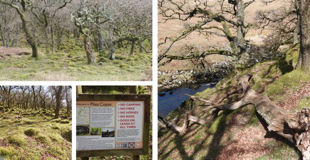
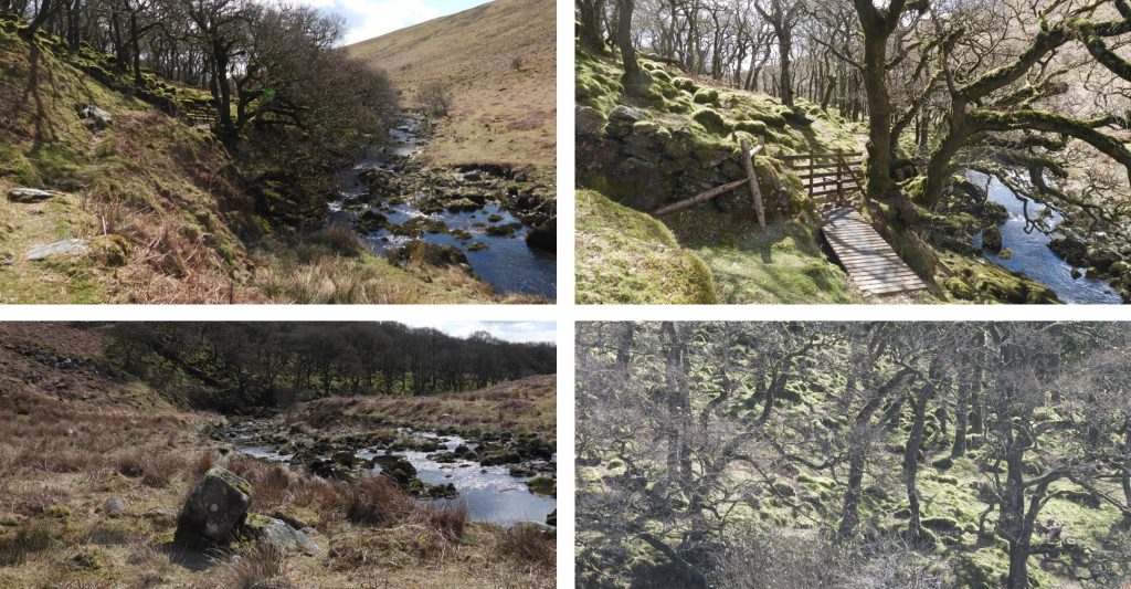
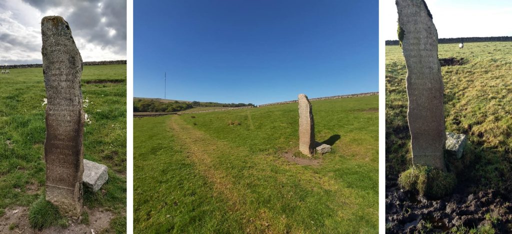
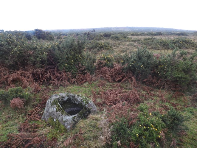
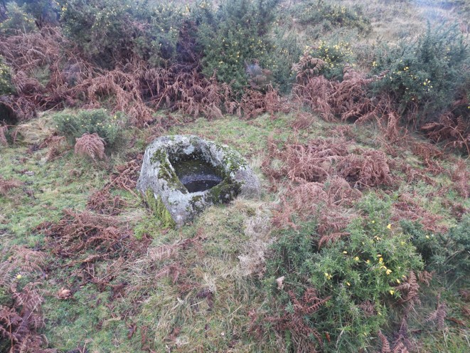
15th June 2012: A BBC short film was released suggesting that new research had found that Ice age glaciers helped shape Dartmoor. One place mentioned to show glaciation was near the East Dart bee hive hut (approx 1:21s into the film).15th June 2012: A BBC short film was released suggesting that new research had found that Ice age glaciers helped shape Dartmoor. One place mentioned to show glaciation was near the Hollowcombe Bottom (approx 1:29s into the film).15th June 2012: A BBC short film was released suggesting that new research had found that Ice age glaciers helped shape Dartmoor. One place mentioned to show glaciation was near the West Okement Valley (approx 1:36s into the film).16th June 1989: It was reported that winter moth caterpillars (Operophtera brumata) estimated to have caused defoliation of over 60% of Piles Copse in several weeks of “nibbling”.16th June 1989: Defoliation of Piles Copse. The oaks affected produced another flush of leaves by Lammas and fully recovered.16th June 1989: Defoliation of Piles Copse. The oaks affected produced Lammas growth, also called Lammas leaves, Lammas flush, second shoots, or summer shoots. It is a season of renewed growth in some trees in temperate regions put on in July and August (if in the northern hemisphere, January and February if in the southern), that is around Lammas day, August 1. 16th June 1989: The Princetown and District History Club was inaugurated on this date. The club was founded by David German, Janet German and Douglas Pidgeon. The author’s parents attended on a regular basis between 2001 and 2005. One of their favourite speakers was on 2nd October 2001 (Chris Chapman on Wild Goose and Riddon photography). In those days the club met at Princetown Primary School (hence the pictures). In 2008, the community centre was built (officially opened by HRH, the Prince of Wales in September 2009). The History Club moved to the community centre when it opened.17th June 1960: The Bill Mudge Memorial Stone, remembering a Huccaby farmer. This memorial can be found on Laughter (Lough) Tor.17th June 1822. On this date it was recorded that Thomas Pomeroy for building a Cart Linhay at Huckworthy Mills was allowed £5 19s 3d. Source: Mike Brown CD – Guide to Dartmoor. Beside the bridge over the River Walkham stands, what was formerly Huckworthy Mill. The original mill buildings stand at the head of a short driveway, a little back from the road and the entrance gate.17th June 1822. On this date it was recorded that Thomas Pomeroy for building a Cart Linhay at Huckworthy Mills was allowed £5 19s 3d. On the site, there is also a fine slate-hung dwelling house. Views of the dwelling house and mill can be had from the west side of the bridge a little way up the hill and from the parapet of the bridge.18th June 1952: Hawson’s Cross was restored in June 1952. The Dartmoor Preservation Association under the guidance of Masson Phillips had a formal gathering at the site on 18th June 1952, to mark the event. The head and part of the shaft of Hawson’s Cross had formed part of a nearby hedge. A replacement shaft had to be made for the cross. (Source: Dartmoor Magazine #47, Summer 1997).19th June 1336: St. Michael and All Angels Church in Cornwood is recorded in the Bishops’ register to have been dedicated by Bishop Grandison on this date. This included the church, high altar and two others.19th June 1336: St. Michael and All Angels Church in Cornwood was dedicated. The church consists of a chancel 28 1/2 ft. long, by 15 ft. wide, a nave 53 3/4 ft. long and two aisles, each of which is divided from the nave by four pillars of monolithic granite and responds, and there are also two transepts, which make the total width of the church to be just over 58 ft. Source: https://www.cornwood-opc.com/cornwood/parish-history. 19th June 1336: St. Michael and All Angles church in Cornwood was dedicated. With regard to the three altars dedicated; The site of one of the altars is shown by a credence in the east end of the north aisle, while probably the third was in a corresponding position in the south aisle, though no trace of it exists.20th June 1833: Bridge at Riddipitt Steps agreed to be built. At a meeting of the Walkhampton Parish Council it was resolved by a majority that a bridge should be erected at Riddipitt Steps.20th June 1833: Bridge at Riddipitt Steps agreed to be built. The bridge (known as Leather Tor bridge now) was built soon after the council agreement for an outlay of under £30.20th June 1887 / 1897: Golden and Diamond Jubilees of Queen Victoria which are celebrated at North Bovey green (two stones) and a “dual” memorial (reverse side is dedicated to Queen Elizabeth Diamond Jubilee) at Yelverton near to the Rock (Udal Tor). The occasion of the Golden Jubilee of Queen Victoria’s accession (20 June 1837) was celebrated with a banquet to which 50 European kings and princes were invited. Queen Victoria’s Diamond Jubilee was rather a more solemn affair with a family thanksgiving service at Windsor Castle on Sunday 20th June 1897. 21st June 1999: The Touchstone, a 2m menhir was erected to mark the new millennium. John Powls was the ‘poet in residence’ when the National Park decided it would be a fitting monument to celebrate the new century with and put his idea forward. He wrote a poem to be inscribed on the stone. The stone for the menhir came from the old prison quarry where Powls was the one-time governor and the poem was carved on it by Kevin Andrews of Polzeath in Cornwall. The menhir was subsequently erected on Rundlestone Crest during the summer solstice in 1999. There was then a dedication ceremony held during the winter solstice in December 1999.
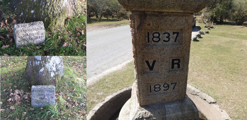
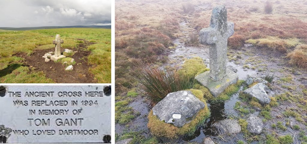
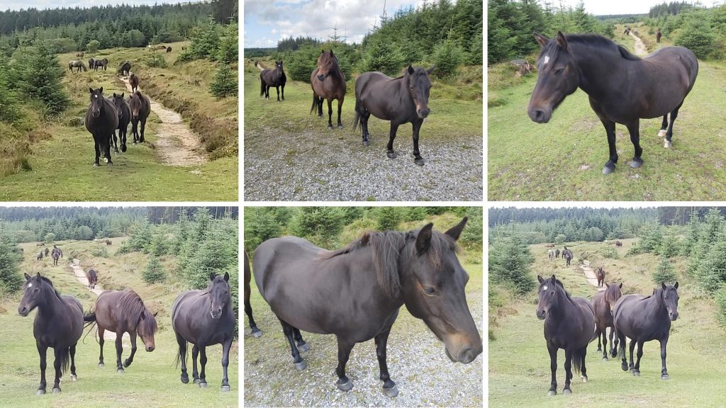
The Touchstone Inspiring This stone touching Open moor and sky Granite land mark Raised to stand For all times As one time; Now, then and ever In love and beauty Our story is a book Always open At the centre Half of experiences Half of Un-named hopes. John Powls 199921st June 1994: There are two crosses on Ter Hill, which are known as the ‘Terrill Posts’. The westerly of these two crosses is a replica and was erected in 1994, being dedicated to Tom Gant, a well known Dartmoor enthusiast and author. The original cross was relocated to the Jack Wigmore memorial at the High Moorland Visitor centre in Princetown, where it was moved to for its own protection.21st June 1951: In the house of commons on this date, Mr Rexton asked the Minister of Agriculture whether he was aware that the famous and hardy breed of the Dartmoor Pony was fast becoming extinct as a pure breed, through horses and other ponies of other breeds being allowed on Dartmoor and what steps he would take to ensure the preservation of the breed in the wild state. The minister Mr T. Williams said he was aware of the problems but “I have no powers that would enable me to prohibit owners of horses or ponies of such other breeds from allowing their animals to be on the moor, nor do I think it necessary to seek such powers.”
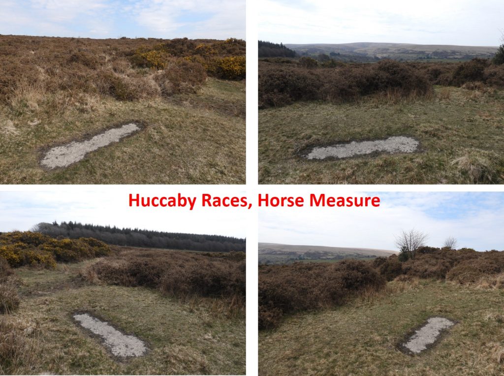
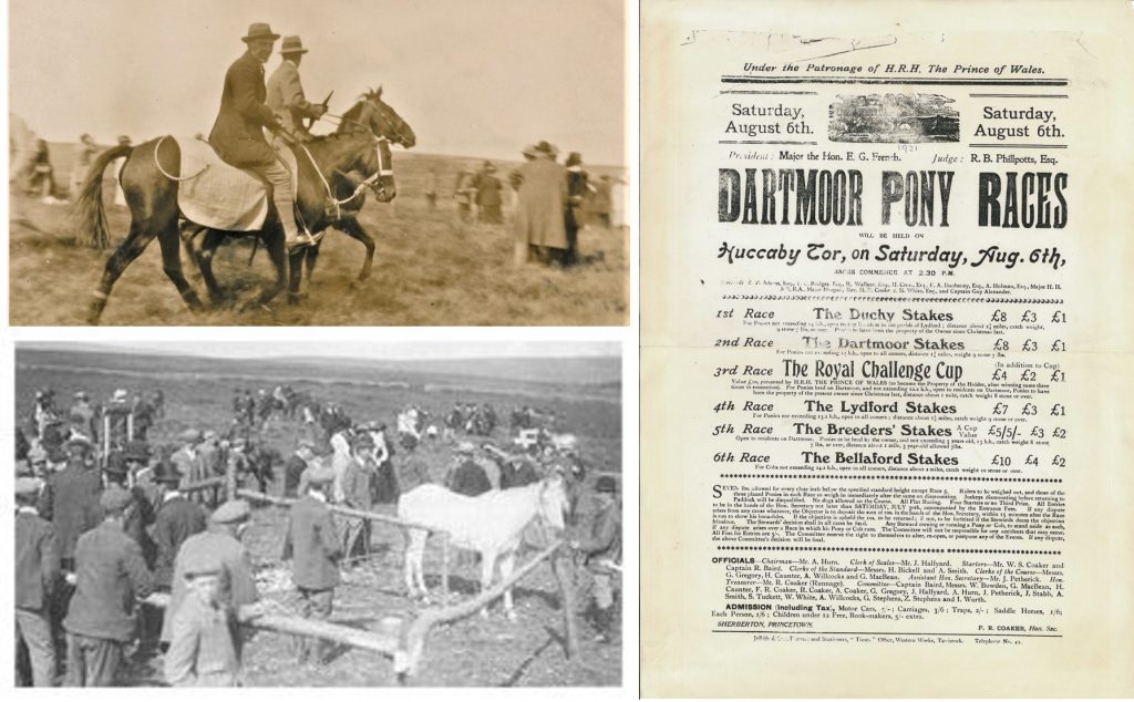
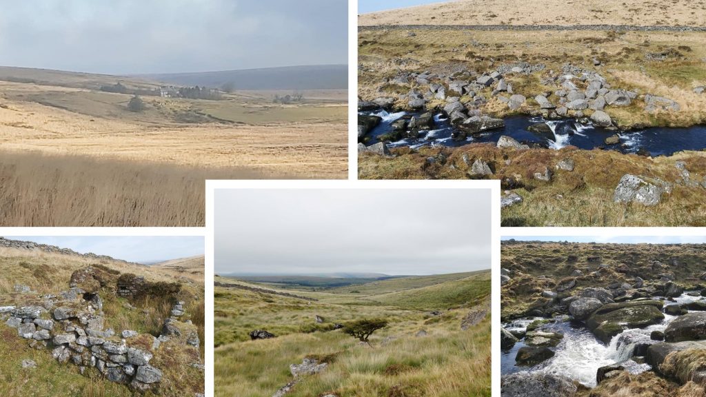
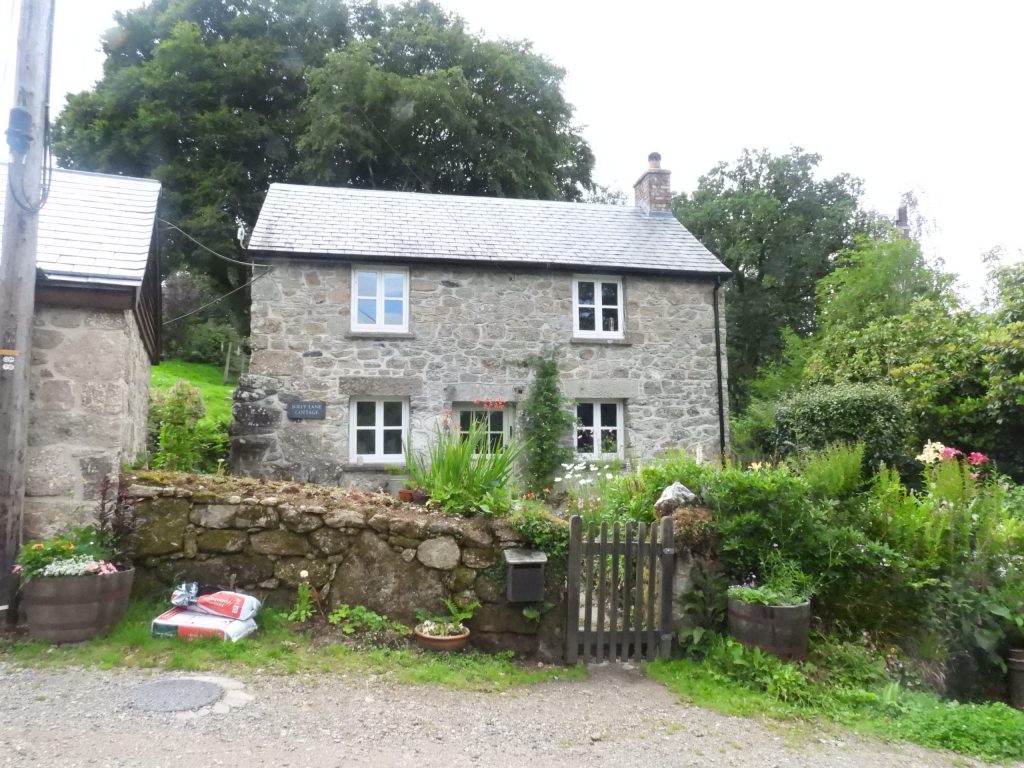
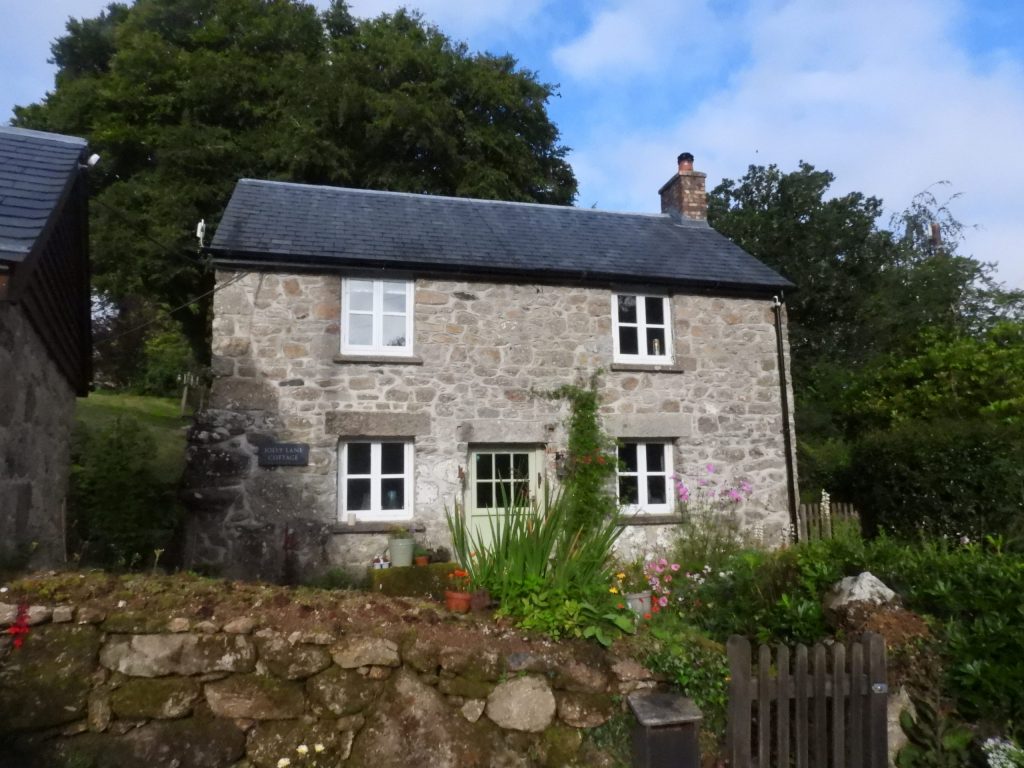
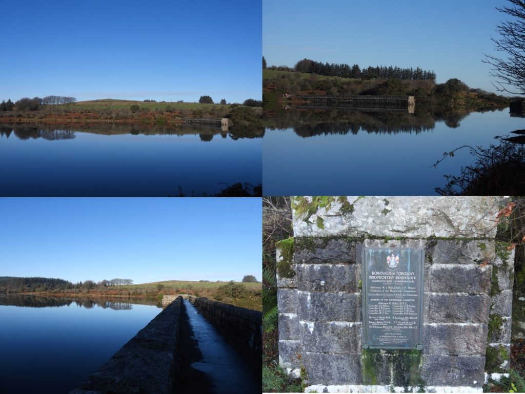
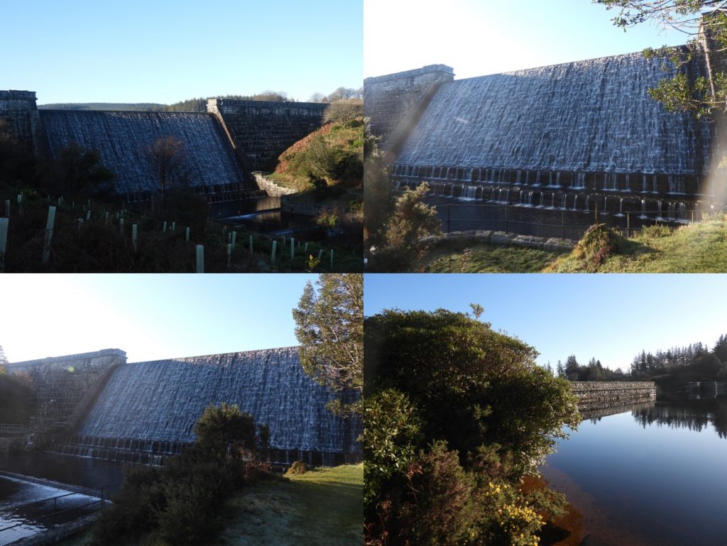
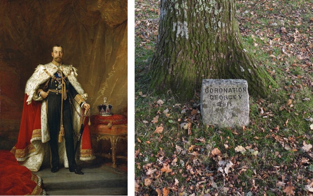
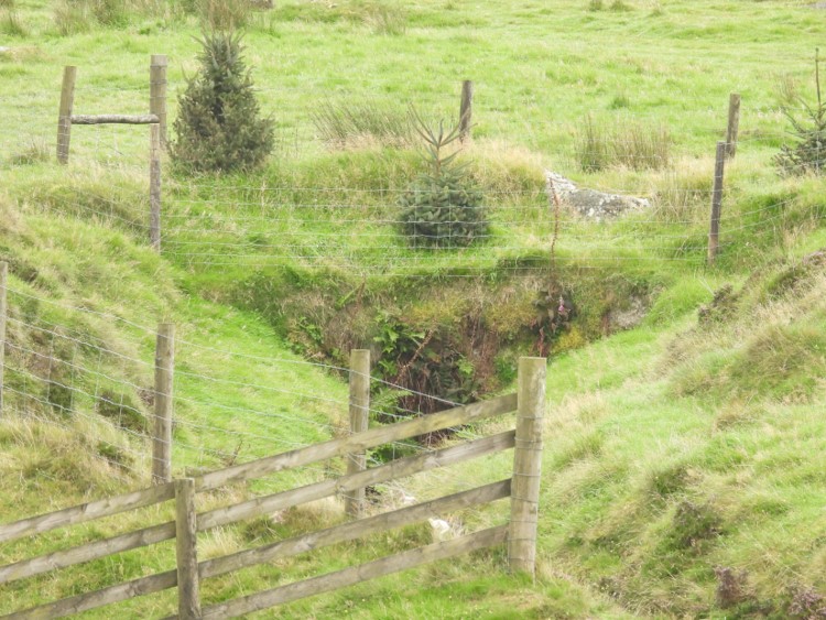
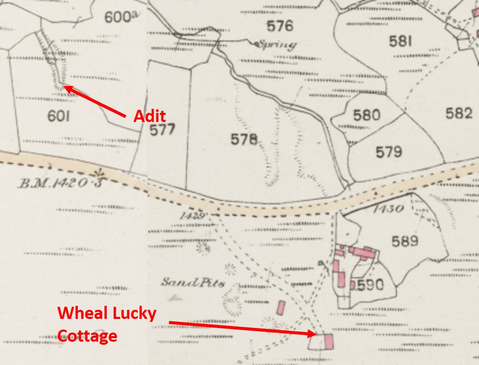
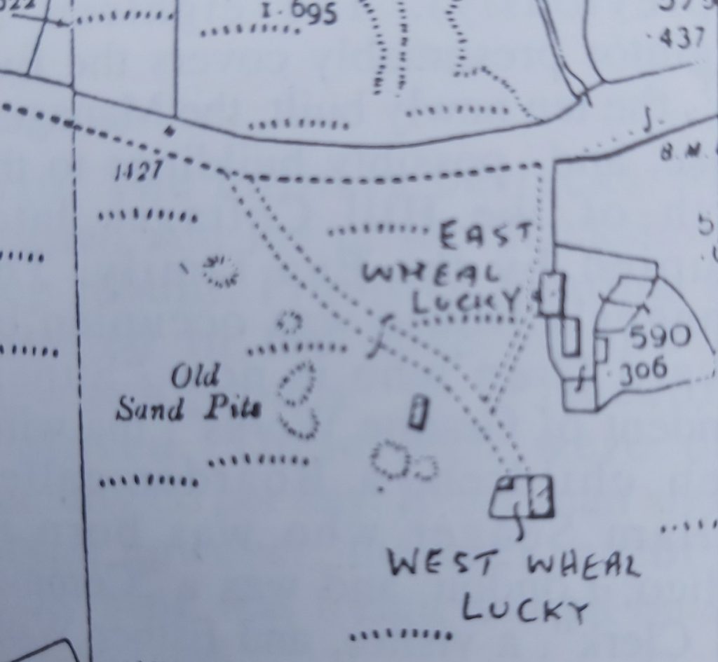
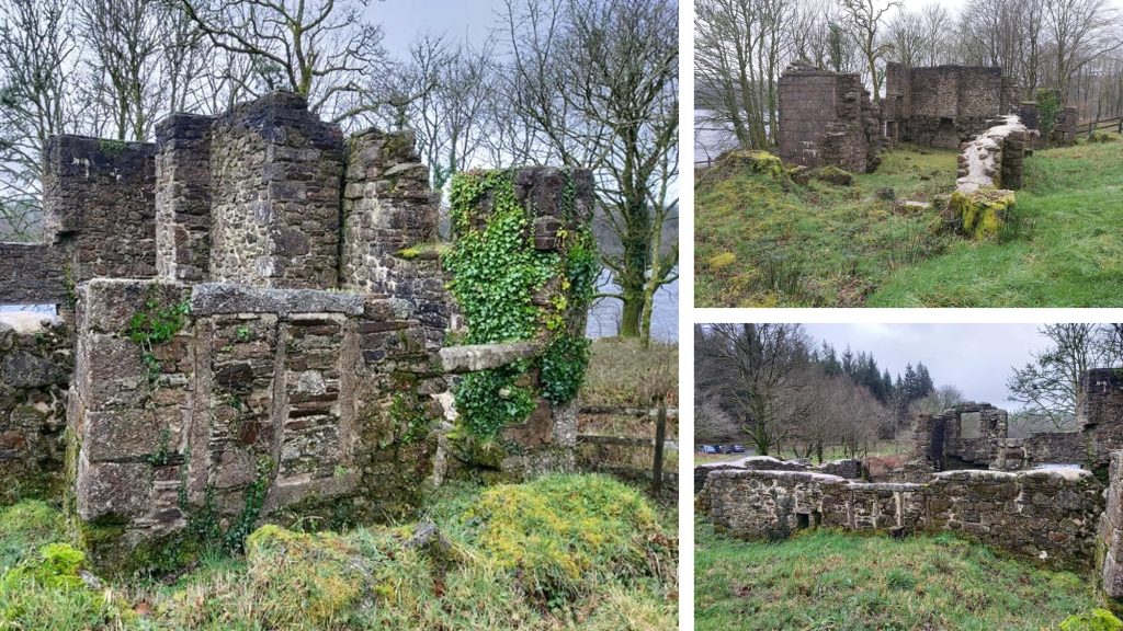
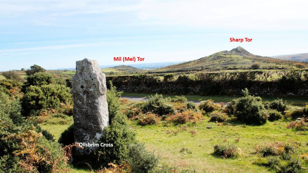
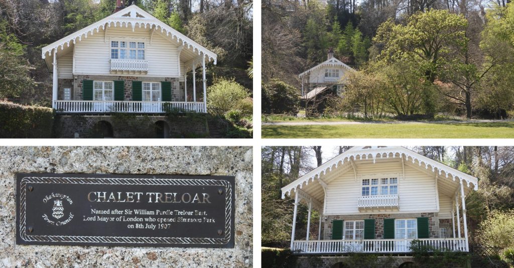
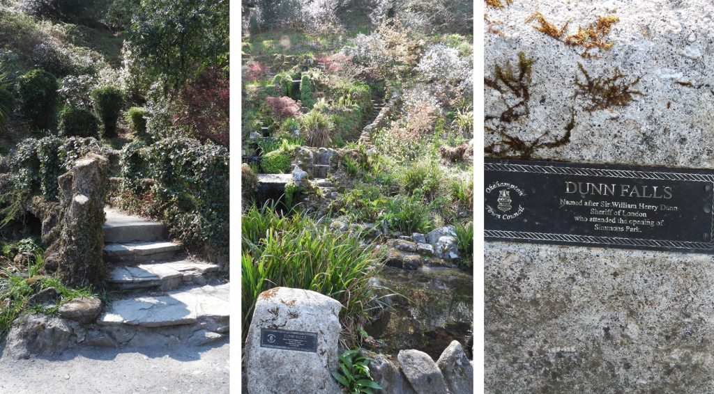
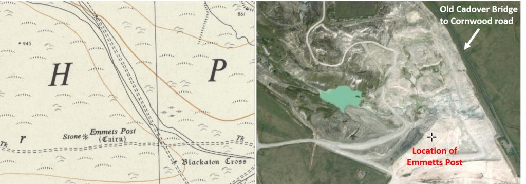
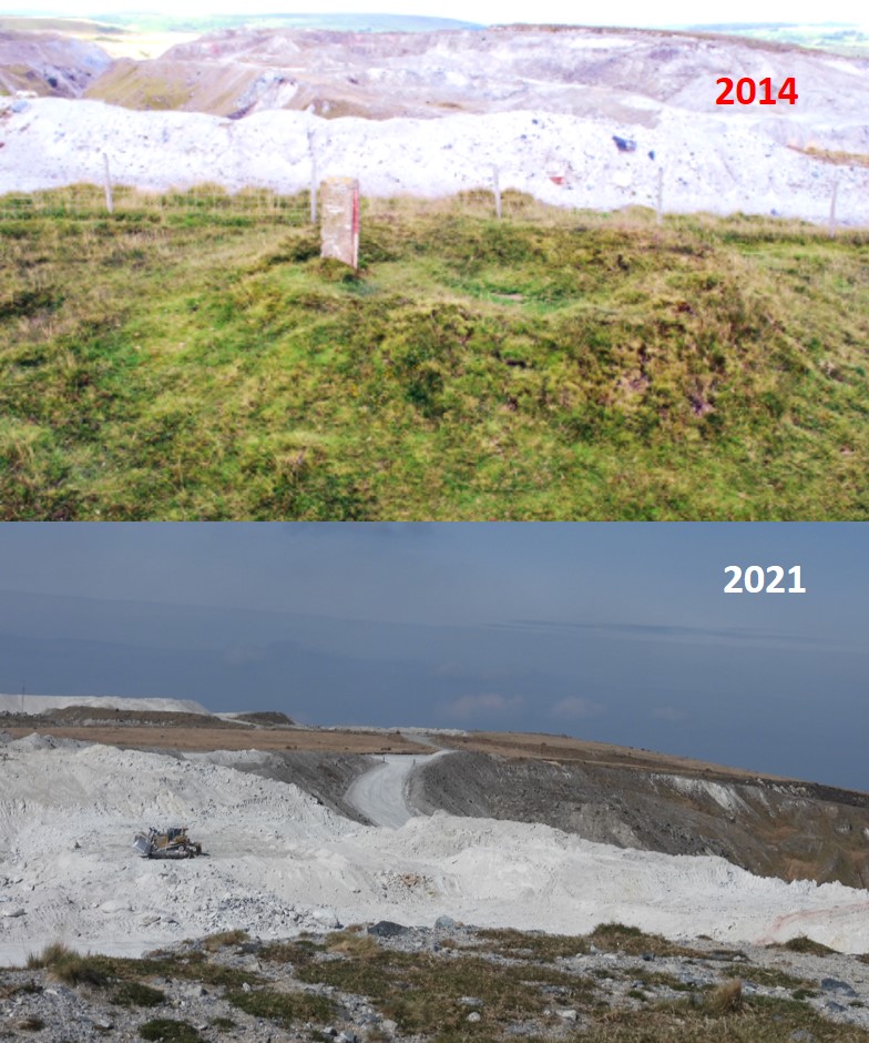
Wind forward to the 21st century, The Dartmoor Pony Heritage Trust is helping to secure the future of the breed. Their mission is: “to secure the long-term future of the native Dartmoor Pony, while inspiring and connecting people with Dartmoor’s wildlife, landscape and heritage. We do this through education, as well as working closely with key partners, conservation bodies and Dartmoor farmers to secure the future of these beautiful animals and ensure their important role in Dartmoor’s ecology is recognised”. More information can be found at: https://dpht.co.uk/21st June 1969: Fox Tor Mire and the Swincombe Reservoir project. On this date, in the Western Morning News, under the headline ‘Huge Project’ the following extract appeared: “The Swincombe scheme involves the construction of a huge triangular reservoir in the heart of Dartmoor. Its sides 2 miles long, it would flood 745 acres of Fox Tor Plain, and contain when full 11,000,000 gallons of water behind a concrete dam 141 foot high”. Source: Dartmoor Magazine article by Tim Jenkinson from Autumn 2001 (no 64) The pictures are of Fox Tor mire and the Swincombe (around the ‘Boiler’) where the reservoir and dam respectively would have been. The picture also shows Sam Parr’s House from the area where the dam might have been built.21st June 1832: Thomas and Sally Satterley, with the aid of friends and local labourers, built ‘Jolly Lane Cott’, the last dwelling to be built in a day. The cottage is believed to have been for Thomas’s father-in-law who wished to remarry and provide a home for his new wife. The cottage is depicted on the Tithe Map and later 19th century historic maps but has been updated and extended in the 20th century.21st June 1832: Thomas and Sally Satterley, with the aid of friends and local labourers, built ‘Jolly Lane Cott’, the last dwelling to be built in a day. The story of the original construction suggests that the local farmers refused to help (being absent at a festival). However, their labourers got together and helped to construct the house. On return from the festival the farmers witnessed that a fire had already been lit in the completed house, which by the law at that time constituted it being a freeholding and so he could not be dispossessed.22nd June 1942: Fernworthy Reservoir was constructed between 1936 and 1942. It was completed on 22nd June 1942, after a few delays due to the war years. The dam is built of concrete and faced with granite supplied from a small purpose dug quarry just a few hundred metres south of the dam. The reservoir covers 37 hectares (76 acres) and is 20 metres (64 feet) at its deepest.22nd June 1942: Fernworthy Reservoir was completed on 22nd June 1942. The reservoir is fed by primarily by South Teign River, Assycombe Brook and Lowton Brook. The reservoir gravity feeds into Trenchford Reservoir which supplies Torquay with drinking water. The reservoir holds up to 380 million gallons of water.22nd June 1911: The Prince of Wales was proclaimed King George V following his father’s death on 6 May 1910. His coronation took place at Westminster Abbey on this date. There is a commemorative plaque on the green at North Bovey.22nd June 1871: The Wheal Lucky Mine Sett is leased. The picture shows the Adit from the mine (north of B3357). Hollow Tor in the background.22nd June 1871: The Wheal Lucky Mine Sett is leased. The sett was leased to a J. Goldsworthy, who was captain of Wheal Creber and James Crowell (Ref: Mike Brown – Dartmoor 2001 – A diary of yesteryear). Amongst the standard clauses of mining leases of the period allowed the lessees being permitted to “erect all such engines and machinery and built such counting houses, sheds and other edifices (except burning or smelting houses) as may be necessary”22nd June 1871: The Wheal Lucky Mine Sett is leased. Shown on the map above is Wheal Lucky Cottage (no longer extant). The other buildings in the area shown are named Wheal Lucky into the 21st century22nd June 1871: The Wheal Lucky Mine Sett is leased. Wheal Lucky Cottage has previously been known as West Wheal Lucky, it was mentioned as such in the tithe apportionment in 1844. Wheal Lucky Mine is believed to have been worked from 1797 (at least until 1871). In 1799, the mine was known as ‘Rundle stone’ when it was recorded that it “had just begun working underground and had sunk an adit”. The mine in 1799 was owned by Simpson and Co. (who were also the proprietors of ‘white work’ and ‘videford’ mines). 23rd June 1764: On this date the will of Richard Northmore (once of Longstone Manor) was written. The story begins with the present house which was built in the seventeenth century on the site of one of far greater antiquity, which was the seat of Herbert de Cumba as long ago as 1390. The Elfords were owners of Longstone for nearly 300 years but were finally forced to relinquish their outright ownership and title in 1747, when the estate was assigned in trust in order to settle mounting debts, and was finally offered for sale in 1750, after the death of John Elford. The bulk of the estate was bought by Richard Northmore, a member of a family of wealthy yeoman who had farmed in the district for countless generations. 23rd June 1764: On this date the will of Richard Northmore (once of Longstone Manor) was written. The prosperity of the Northmore’s during this period of their long history, and the extent of their property holdings and numbers of livestock owned, can be best illustrated by this will. Here is a very small portion of that will: “To wife Mary, Elizabeth wife of son Richard, and Jacob Creber of Meavy, son in law, all those my lands tenements and premises called or known by the name of Chubstone Leeford and Sheepstor…and all estate right title..[etc]…in trust to permit and suffer my son Richard Northmore and his assigns to have hold and enjoy the same premises and receive and take the rents Issues and profits thereof to his and their own use and benefit until my Grandson Richard Northmore son of my said son Richard Northmore shall have attained his Age of twenty five years”. The pictures include John Elford windstrew (bottom left), which can be found near the ruins of the manor.24th June 1988: HRH Prince Edward visited the Dartmoor Training Centre at Prince Hall. The bridge here is a beautiful span over the West Dart.24th June 1882: The Okehampton Commoners at a vestry meeting in the Town Hall agreed to approach the War Office for exacting compensation for live firing practice on the commons. Source: The Dartmoor Diary 1991 by DNP.24th June: A local custom which survived on and off until the 1950s was the “rolling of the wagon wheels” from Mil (Mel) Tor. The wheels were sent on their way down to the (double) Dart, nearly 200 metres below but few ever made it due to the clitter and trees in Miltor Wood. The only picture the author had of Mel Tor close up was from a very wet and foggy day in 2014, so a longer distance alternative from 2018 has been used. The exact date of Midsummer does vary among different cultures, but is primarily held close to the Summer Soltice. In England, traditionally we’ve celebrated Midsummer’s Day on 24th June, with the actual Summer Solstice taking place on 20th or 21st June. 24th June 1843: James Woodley (of Halsanger Manor) granted the Halsanger Mine Sett to James Maxwell and John Williams. It is recorded that the terms and conditions of the lease were pretty standard for those of that period. It would seem that the prospective lessees did not take up their grant for the lease. The propose rent was £50 per annum or 1/15 of profits which ever is larger (in 2024 this rent would be around £8000), which perhaps was the reason why the lease was never taken up. Of note is the original Halshanger Manor was built on the site of a 12th/13th century manor house. However, that building was totally demolished in 1806 and the house seen today was constructed on the site with entirely new material in 1807.24th June 1843: James Woodley (of Halsanger Manor) granted the Halsanger Mine Sett to James Maxwell and John Williams. There is no evidence of where any prospect might have been considered to be located. Bag Tor mine is located to the north of Halsanger Manor, where historically there has been some mining success. That said the area around Cold East Cross, where there is evidence of the Halsanger Manor bounds can still be found a prospect might have been considered. 24th June 1843: James Woodley (of Halsanger Manor) granted the Halsanger Mine Sett to James Maxwell and John Williams. The photograph is another Halsanger Manor boundary marker set up by Philip Woodley in 1746. The author assumes Philip and James Woodley were related (probably 3 or 4 generations apart)24th June 1938: On this date the last known lease for working the Birch Tor and Vitifer Mine sett was issued. The recipient of the lease was G.N.T. Taylor for £20 per annum rent and one – thirtieth share from the profits from all tin sold (Ref: Mike Brown – Dartmoor 2001). At this time there was limited underground and surface work only and the mine closed and was finally abandoned around 193925th June 1753: This was the second (of two days) of the earliest known occurrence of an organised horse racing event on Whitchurch Down. Horse racing was encouraged by the Duke of Bedford and continued spasmodically under local hunts into the 1920s.25th June 1753: This was the second (of two days) of the earliest known occurrence of an organised horse racing event on Whitchurch Down. The pictures include: a) Whitchurch Down Cross which was a waymarker for a track which would have been regularly used by the monks on their journeys to the Tavistock Abbey from both the Buckfast Abbey, via the Monks’ Path, and the Plympton Priory and b) The “Pimple”, which was designed by Sir Edwin Lutyens and built of local Hurdwick stone with a flared slate roof in 1914 to surmount an underground reservoir. 26th June 1907: Venford Reservoir commemoratively opened. The Engineer was Fred William Vanstone and the Contractors were Hawking & Best, Teignmouth. The dam was built to catch water from the Venford brook as it makes it way down from Holne Moor. The reservoir holds approx. 198 million gallons of water and covers an area of approx 33 acres.26th June 1907: Venford Reservoir was commemoratively opened by F. Layland-Barratt Esq. M.P.26th June 1907: Venford Reservoir was commemoratively opened. There are 52 standing boundary marker stones across Holne Moor and surrounding the dam which define the watershed. Stones 1-6 are shown in the pictures. The Paignton and Urban District Council (PUDC) Water Works Boundary Marker Stones of Venford Reservoir are inscribed PUDC on one side and RD/H on the other. RD/H stands for ‘Richard Dawson, Holne’, from whom Paignton Water Works purchased 700 acres of Holne Moor, paying £11 per acre. (Source: Dartefacts)27th June 1953: Butterdon Hill stone alignment and cairn, first listed on Historic England register (ref 1012486). The database states: “The Butterdon Hill single stone alignment runs for over 2km along the ridge between Butterdon Hill and Piles Hill and is the second longest stone alignment on Dartmoor”.27th June 1953: Butterdon Hill stone alignment and cairn, first listed on Historic England register (ref 1012486). The database further states: “One stone in the row c.300m south of this northern terminal has a cross incised on its west face and is known as Hobajon’s Cross. The line has been adopted as the Harford Moor/ Ugborough Moor Common Land boundary and includes introduced modern boundary stones”.27th June 1953: Butterdon Hill stone alignment and cairn, first listed on Historic England register (ref 1012486). The database further states: “The stones are up to a metre in height and are spaced at intervals of 1m to 1.5m. There is a cairn 10.5m in diameter and 0.3m in height, with a retaining kerb at the southern end of the alignment and a recumbent stone, 2.56m in length, known as the Longstone, which is considered to have been the northern terminal”. Of course, the Longstone is no longer recumbent having been re-erected in late 2019.28th June 2002: Simmons Park, Okehampton was recorded on Historic England register (1001625). The picture is at the northern entrance.28th June 2002: Simmons Park, Okehampton was recorded on Historic England register (1001625). Simmons Park gets its name from Sydney Simmons, a local man who made his fortune in America. In 1906, he gave Okehampton Council the funds for this commons site and transformed it into a park. The basis of the money was that he would have a big say in the design of the park including the park having five almshouses, in three separate buildings. One side of the plaque on the standing stone near the northern entrance says: THIS PARK PRESENTED BY SYDNEY SIMMONS OF OKEHAMPTON NORTH FINCHLEY WAS OPENED JULY 8TH 1907 BY THE RIGHT HON SIR W P TRELOAR LORD MAYOR OF LONDON28th June 2002: Simmons Park, Okehampton was recorded on Historic England register (1001625). ‘The Nook’, is one of the five almshouses and is a single storey lodge with half-timbered gables, bay windows, and a timbered porch on the west façade. The east façade which faces the East Okement River has an exposed basement which incorporates a ground floor verandah.28th June 2002: Simmons Park, Okehampton was recorded on Historic England register (1001625). ‘The Rock’ and ‘The Rest’ are semi-detached dwellings near the north entrance gates and are not symmetrical, giving the building the impression of a single, grand house.28th June 2002: Simmons Park, Okehampton was recorded on Historic England register (1001625). At the south end of the park stands the early 20th century Swiss chalet known as ‘Treloar’. This picturesque building contains two almshouses, comprising two storeys over a basement, with deep overhanging eaves, ornamental bargeboards, and other ‘Swiss’ ornamental motifs. Chalet Treloar was named after Sir William Purdie Treloar bart, Lord Mayor of London, who opened the park on 8th July 1907. Sir William was knighted in 1900 and made Baronet 1907.28th June 2002: Simmons Park, Okehampton was recorded on Historic England register (1001625). Dunn falls is close to Chalet Treloar and are named after Sir William Henry Dunn, Sheriff of London who attended the opening ceremony of the park in 1907.29th June 1960: A bowl barrow at Emmets Post was first registered on Historic England (registration ref 1020566). On the 1st September 2014, Oxford Archaeology began an investigation into the barrow in order to establish how it was constructed and used / re-used. The excavation period was completed by the end of September 2014. Prior to the excavation, in 2001 the mineral companies agreed to give up all tipping areas within the Dartmoor National Park provided they could merge the Lee Moor and Shaugh Lake pits. A consequence was the loss of this barrow as can be seen from the map / google earth image. 29th June 1960: A bowl barrow at Emmets Post was first registered on Historic England. According to the register “This monument includes a bowl barrow of Late Neolithic to Bronze Age date, located on a level hilltop with wide views across the Upper Plym Valley to the north west. The barrow survives as a low mound measuring 12m in diameter and up to 1.5m high, with a 2m wide, 4m long and 0.4m deep oval depression in the centre, most likely representing excavation in antiquity. Although no longer visible at ground level, a quarry ditch, some 2m wide, will encircle the mound, surviving as a buried feature. A 19th century boundary stone (Emmets Post) , Listed Grade II, inserted into the south side of the mound bears the letters SM on its west side and LM on its east, denoting the boundary between the setts of the Shaugh Moor and Lee Moor china clay companies”. The two pictures are quite stark, in 2014 just prior to the bowl barrow excavation vs. 2021 where the excavations from the mineral companies having totally obliterated it.29th June: The Owen’s Book of Fairs from 1824, stated that Buckfastleigh had a sheep fair on this date. There was a horned cattle fair on 24th August. The author has assumed that the fair might have taken place in Market Street (photographs)30th June 1995: Beatland Corner socket stone: a wayside cross 900m south east of Shaugh Prior church first registered on Historic England register (ref 1009185). The register states: “The monument includes a rectangular socket stone for a wayside cross, formed of moderately coarse granite. It is situated at Beatland Cross on the east side of the road leading to Cadover Bridge, and about 22m north of the actual crossroads. The west edge of the stone is 3.5m from the road edge to the west. This location is on an important medieval route northwards from Plympton”. The picture was taken in December 2020 and shows Hawks’ Tor on the hillside behind.30th June 1995: Beatland Corner socket stone: a wayside cross 900m south east of Shaugh Prior church first registered on Historic England register (ref 1009185). The register further states: “The base dimensions of the stone are 0.73m by 0.63m. The maximum height of the stone above ground surface is 0.54m. On the top surface of the stone a neat rectangular socket has been cut, with straight sides. On the west and south sides the inner edge of the socket is only 0.12m from the outer edge of the stone, while on the east side it is 0.18m and on the north side 0.21m. The long axis of the socket is orientated NNE-SSW. The base dimensions of this socket are 0.36m (maximum) by 0.26m. The top surface of the stone has been broken away on the west and south edges of the socket. The present maximum surviving depth of the socket, which is likely to be its original depth, is 0.16m. This socket would once have housed a medieval wayside cross at this important junction”.