A collection of walks, discoveries, insights and pictures of exploring Dartmoor National Park
June 16, 2021
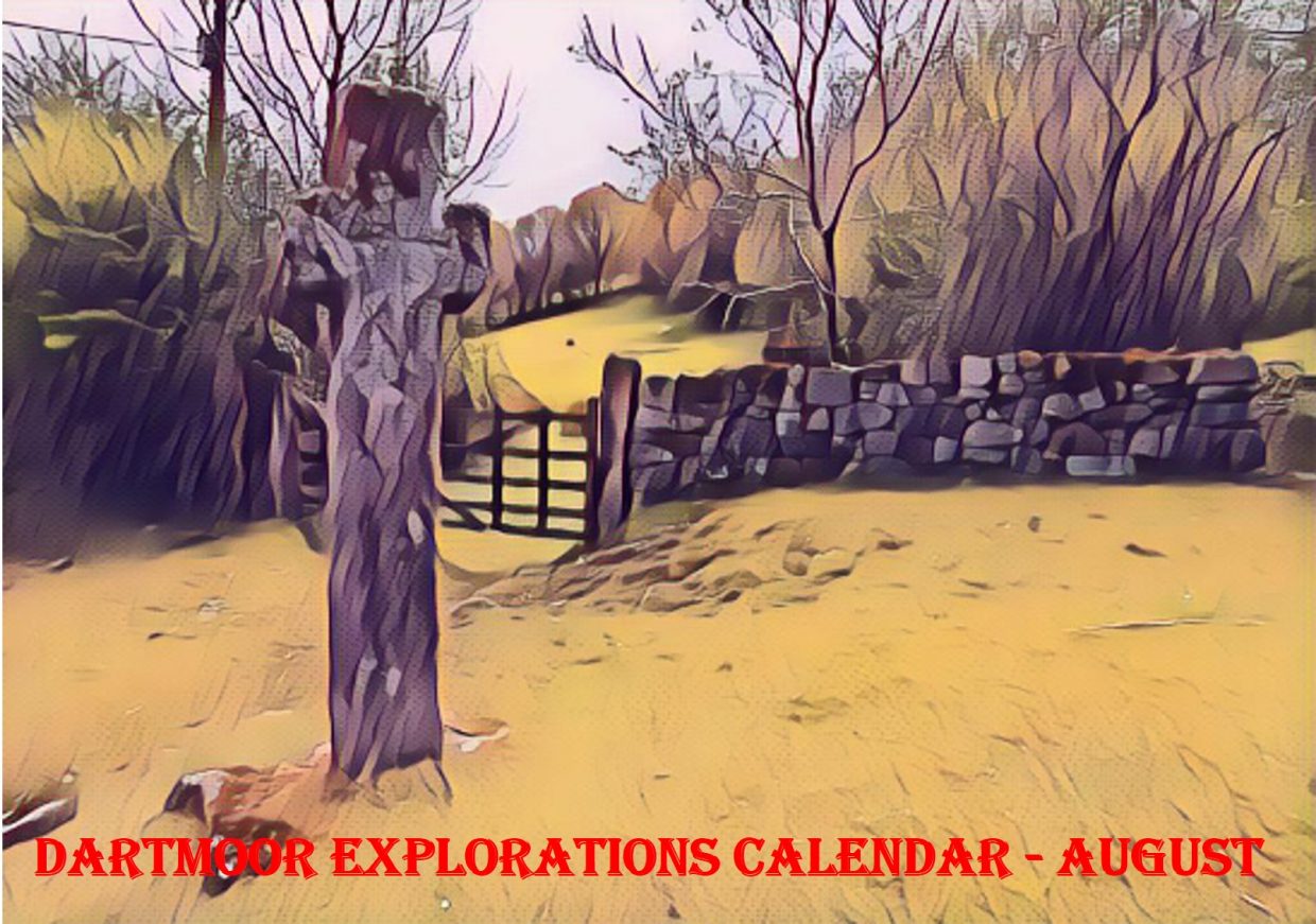
Dartmoor Explorations Calendar – August
In 1991, the Dartmoor National Park Authority (DNPA) published a spiral bound diary to commemorate their fortieth anniversary (1951-1991), called “The Dartmoor Diary”.
Inspired by this publication (and some of the entries in it) and to celebrate the DNPA 70th anniversary year in 2021, the “Dartmoor Explorations Calendar” records an event or story, complemented with photographs for each day of the year.
This page of the Dartmoor Explorations Calendar celebrates August on Dartmoor and its immediate borderlands.
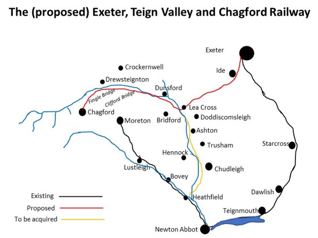
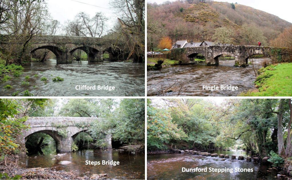
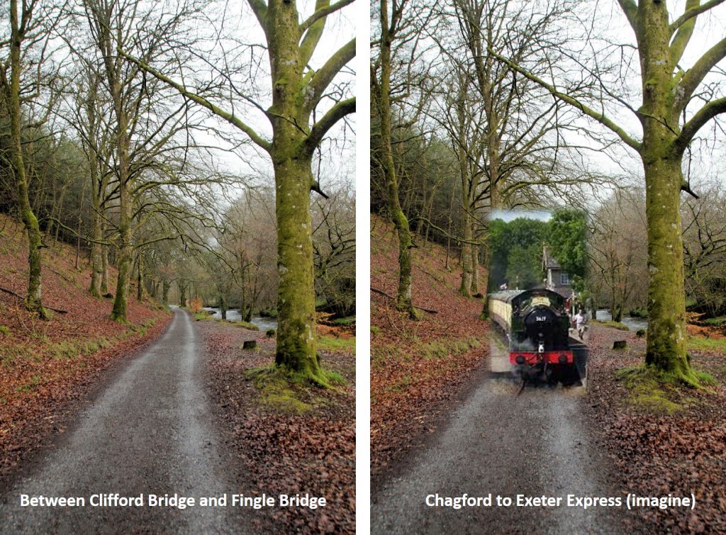
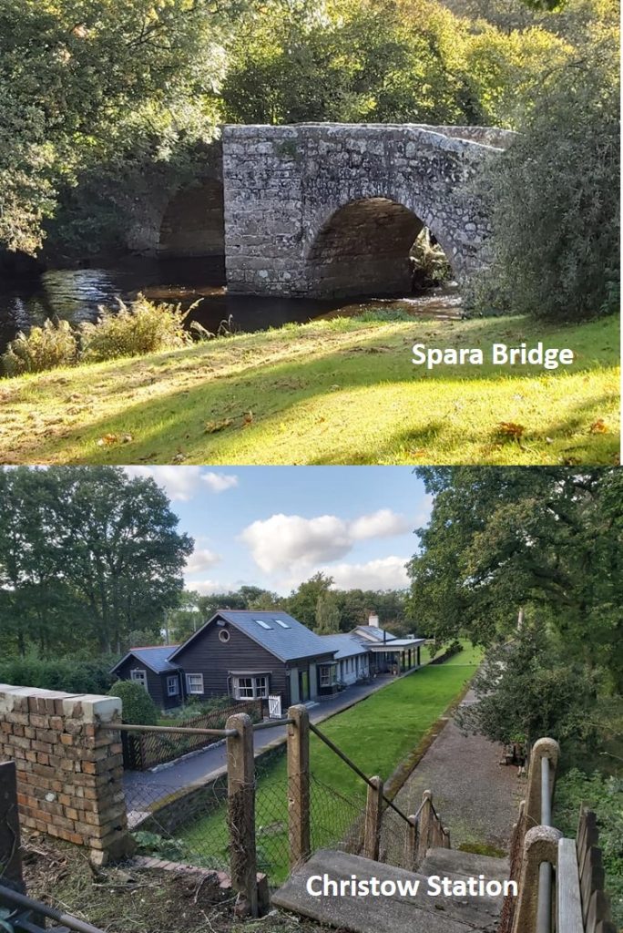
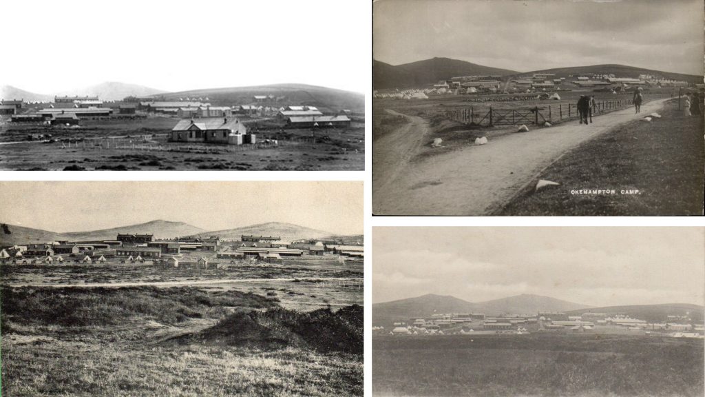
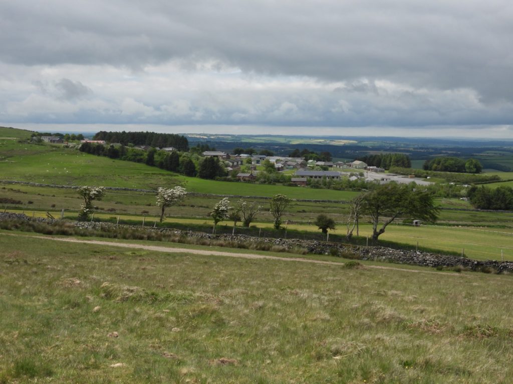
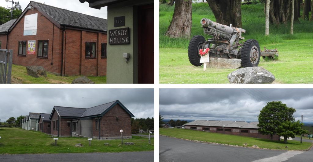
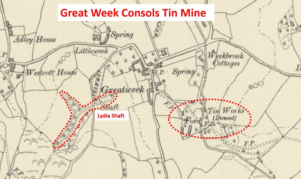
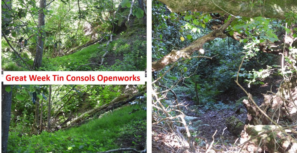
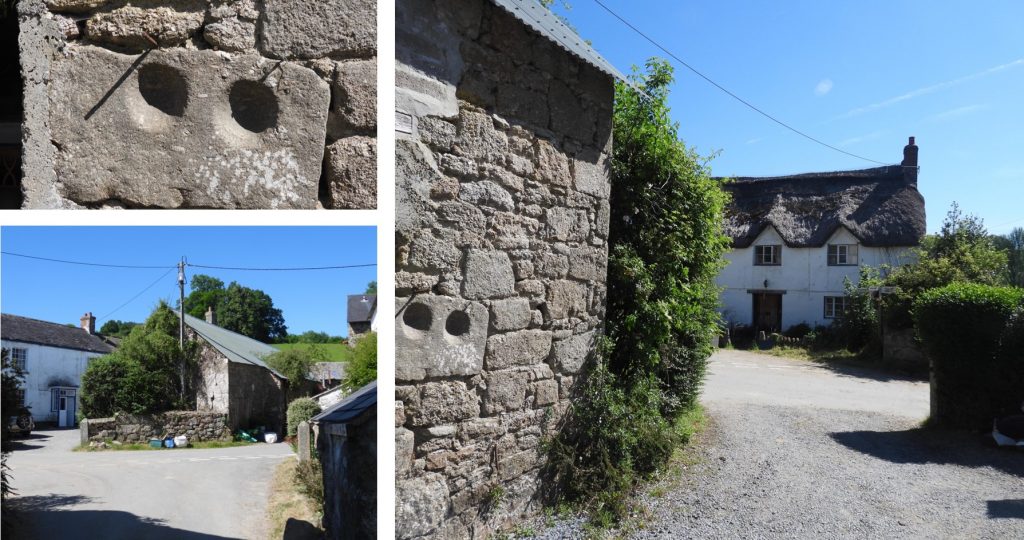
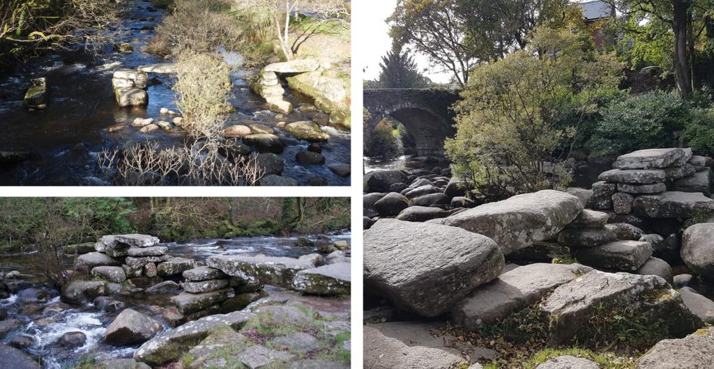
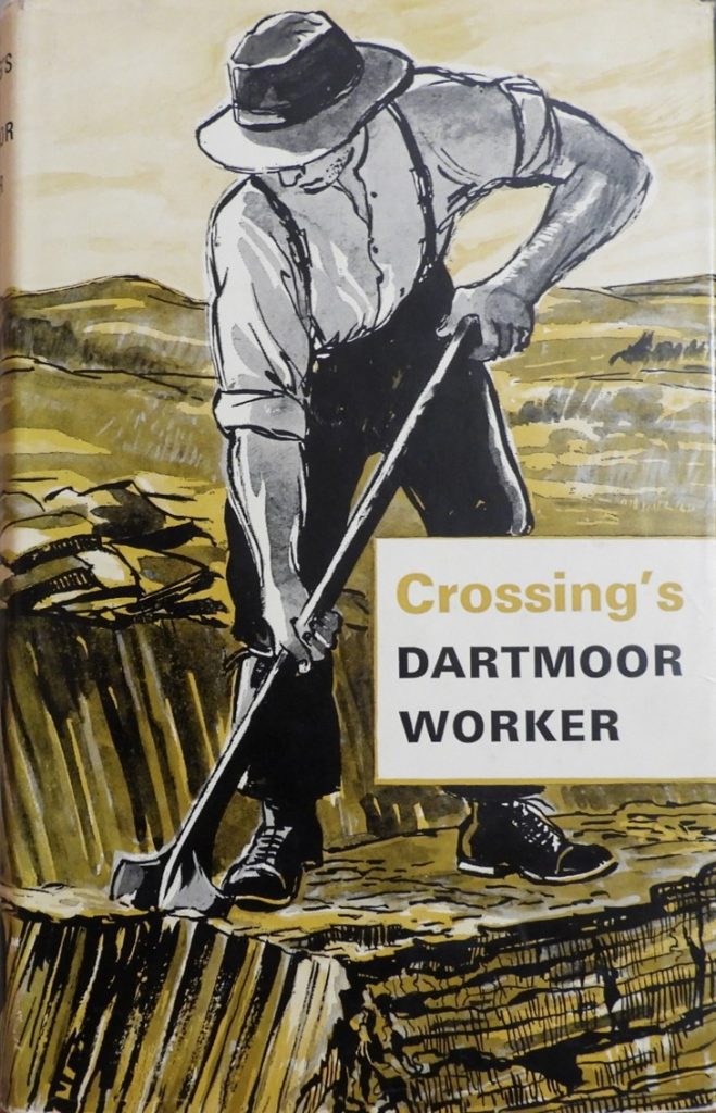
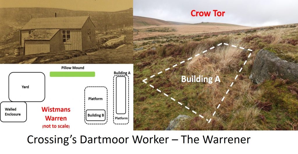
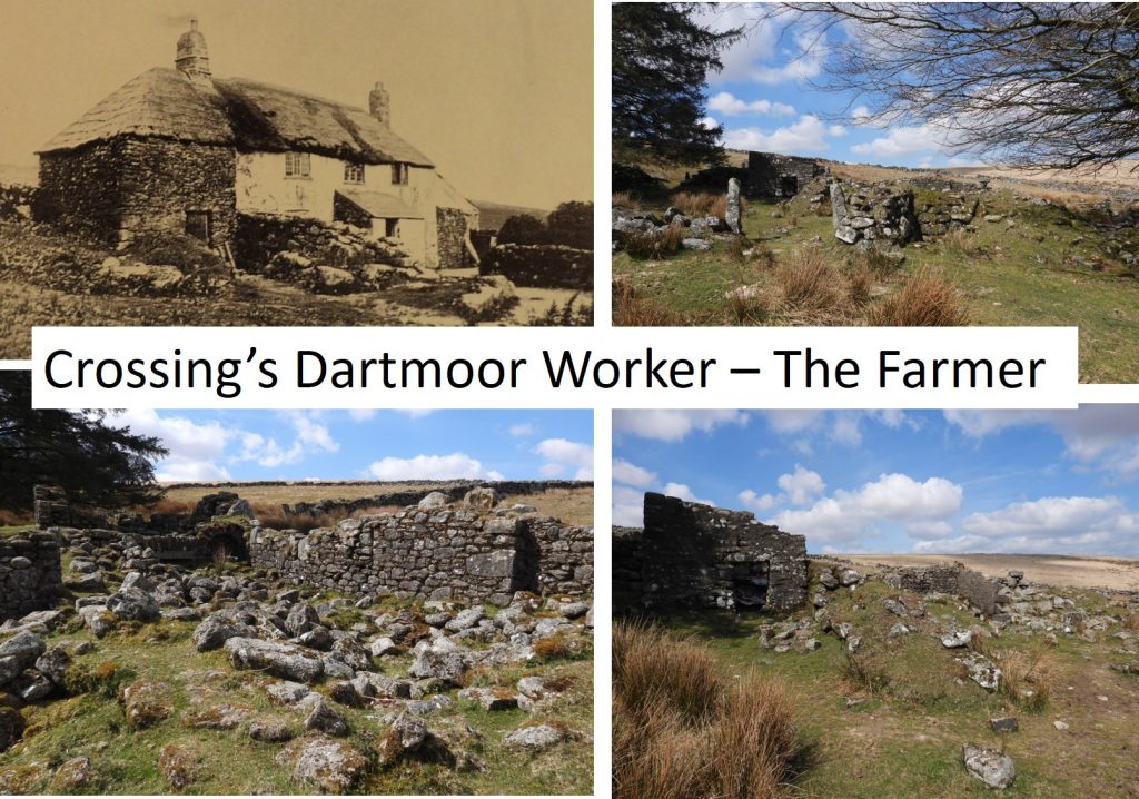
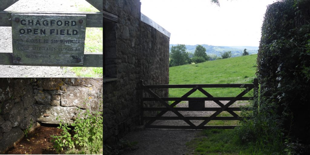
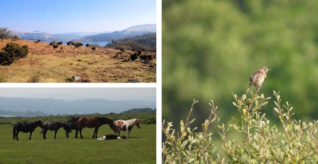
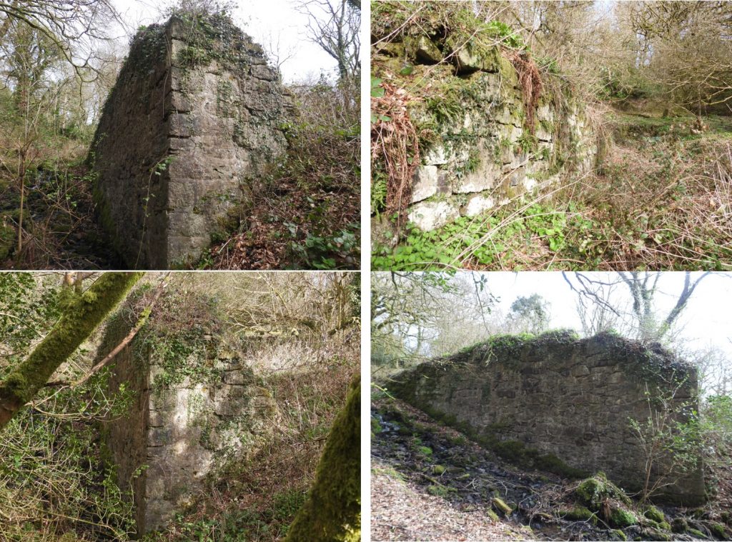
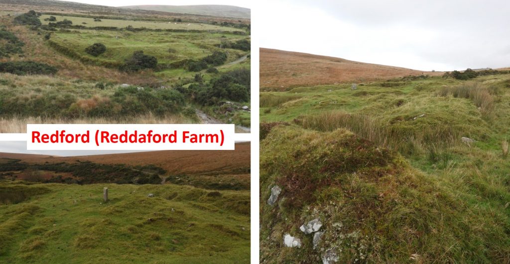
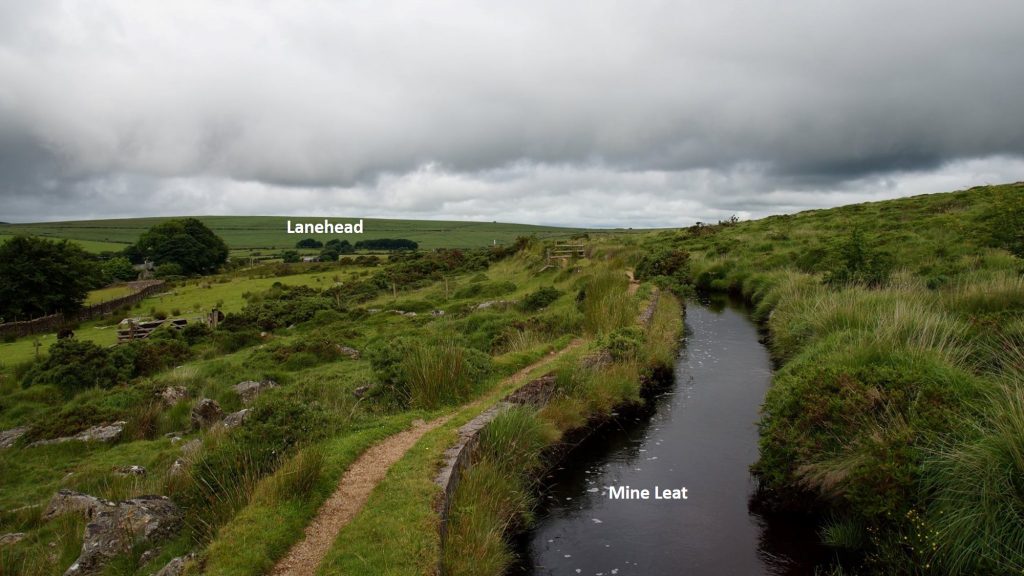
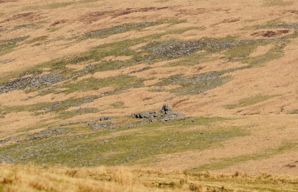
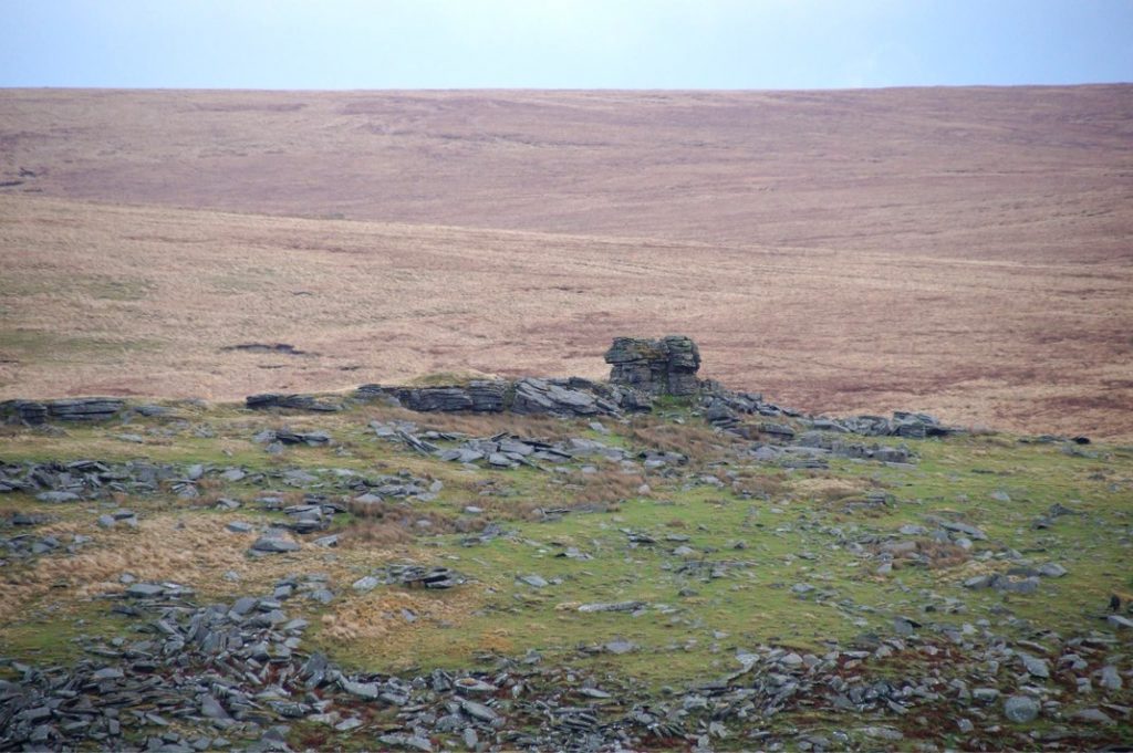
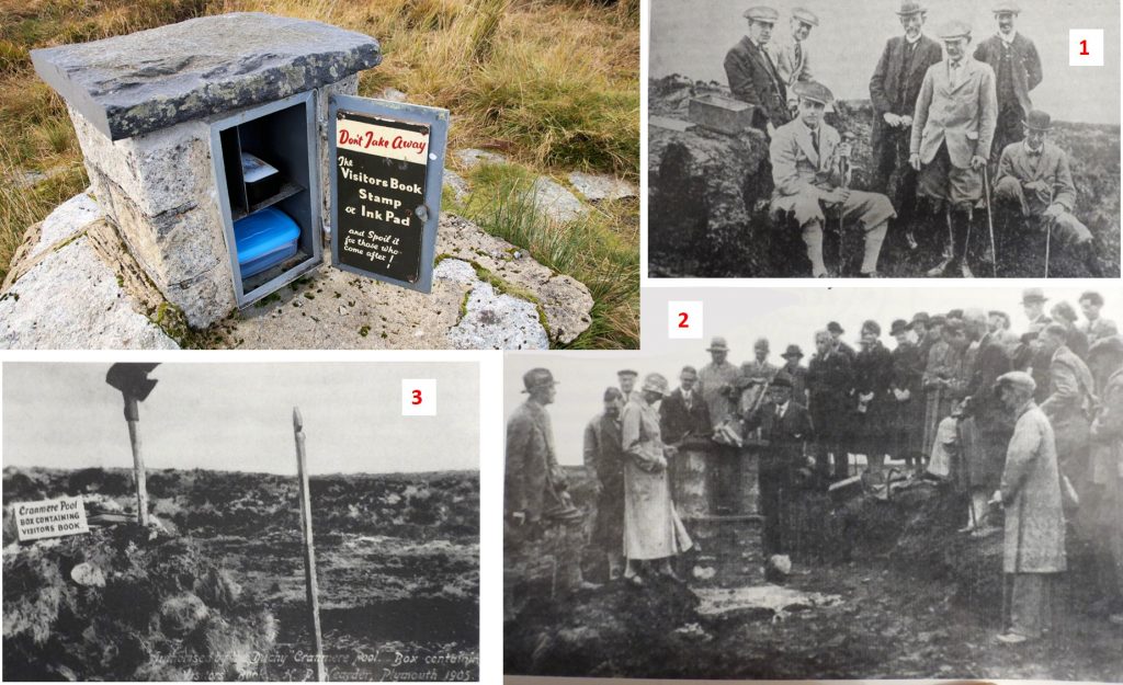
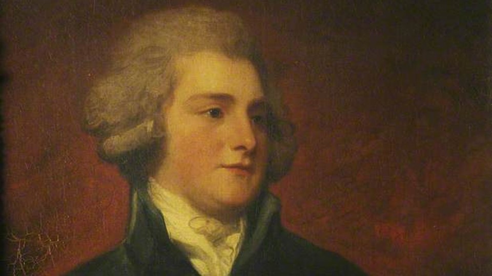
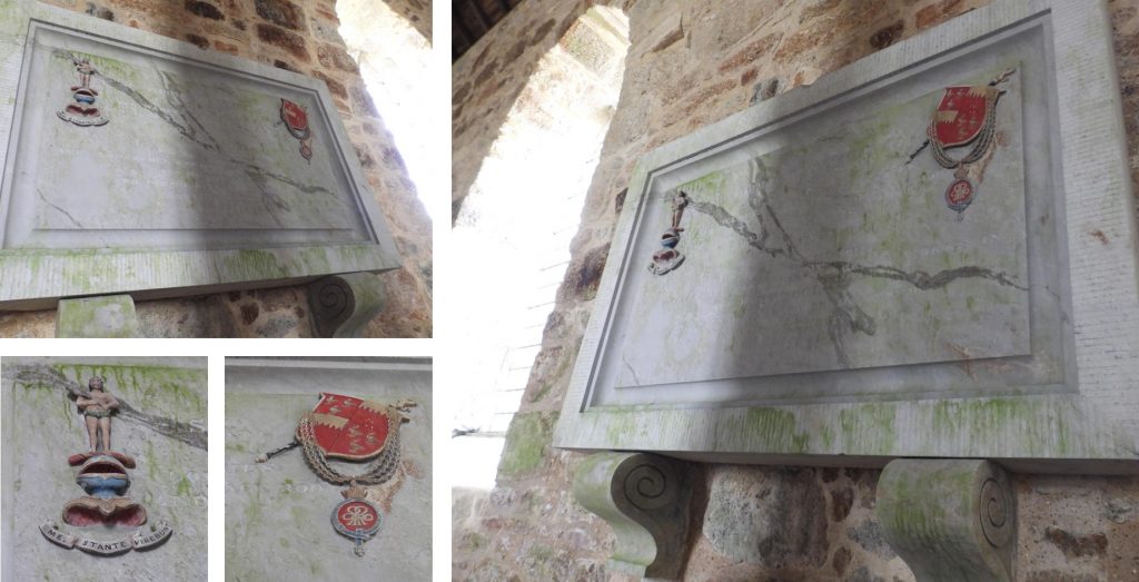
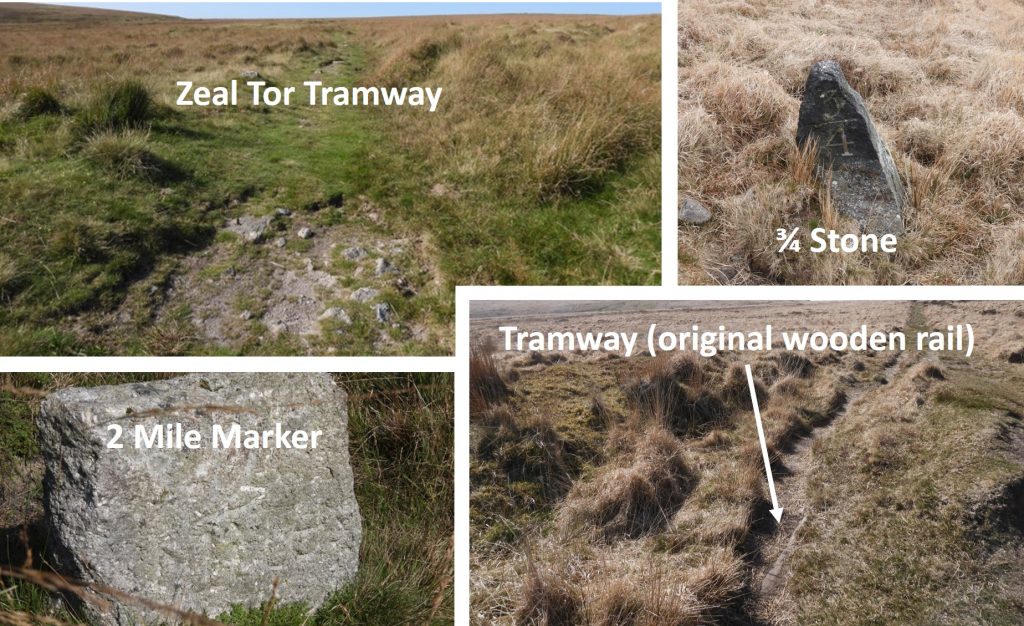
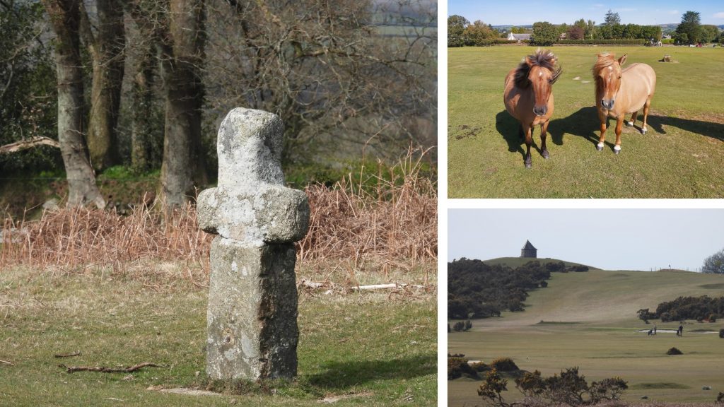
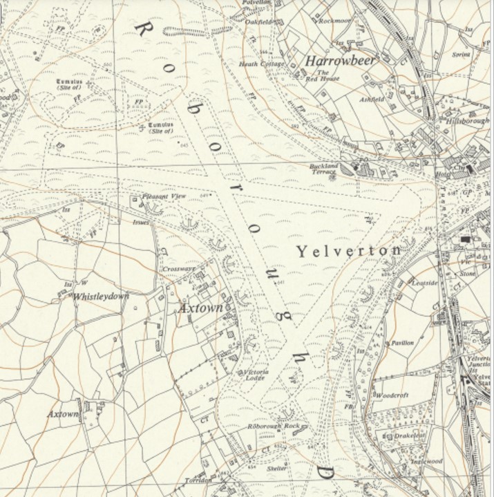
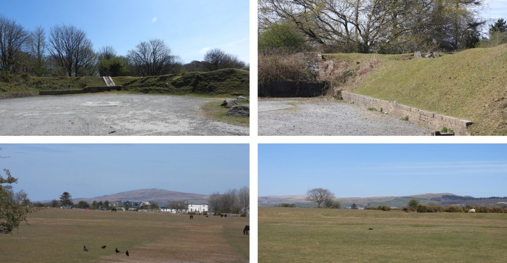
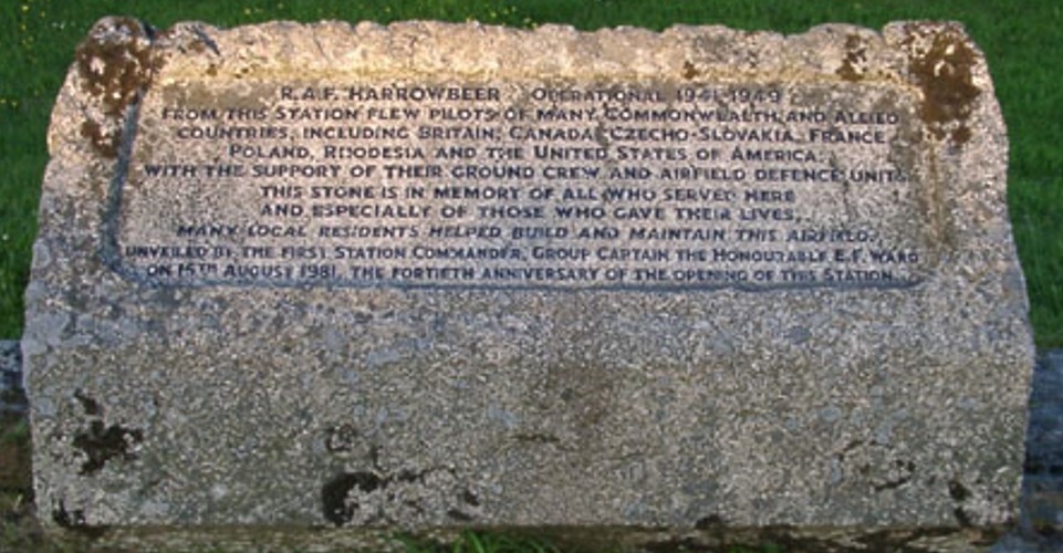
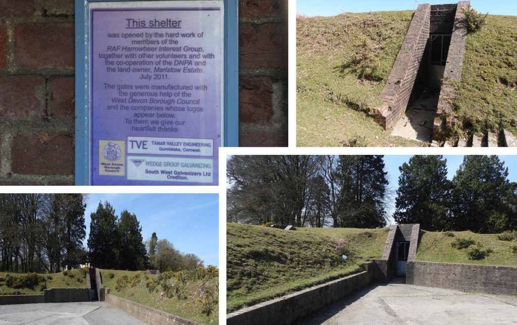
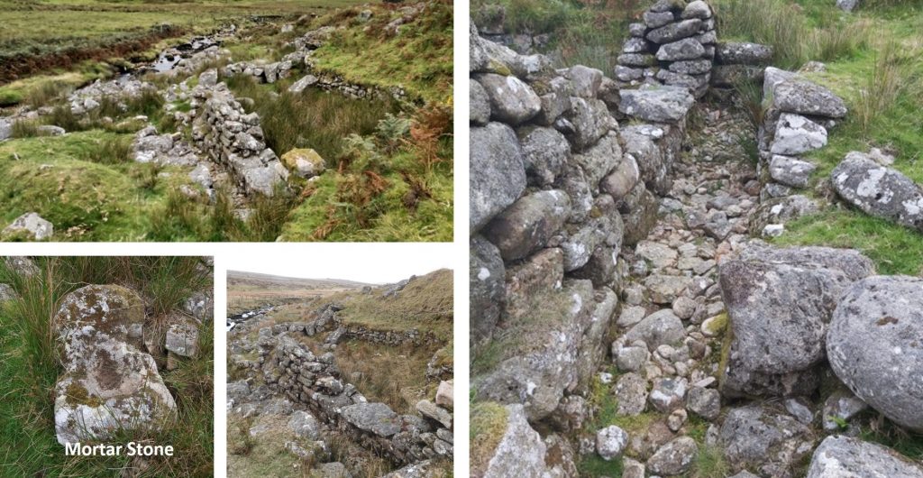
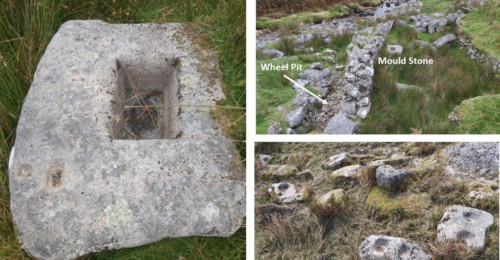
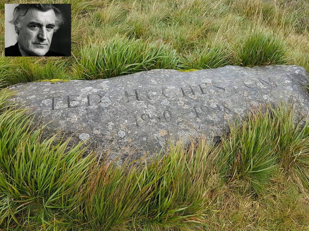
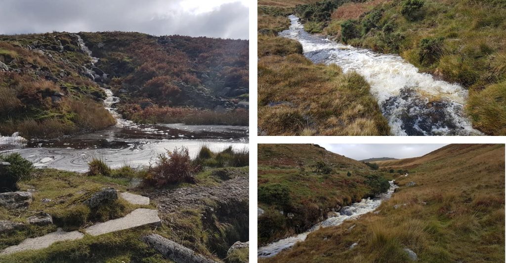
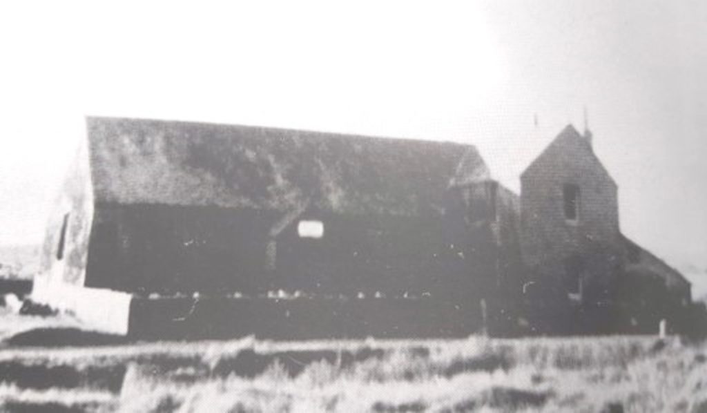
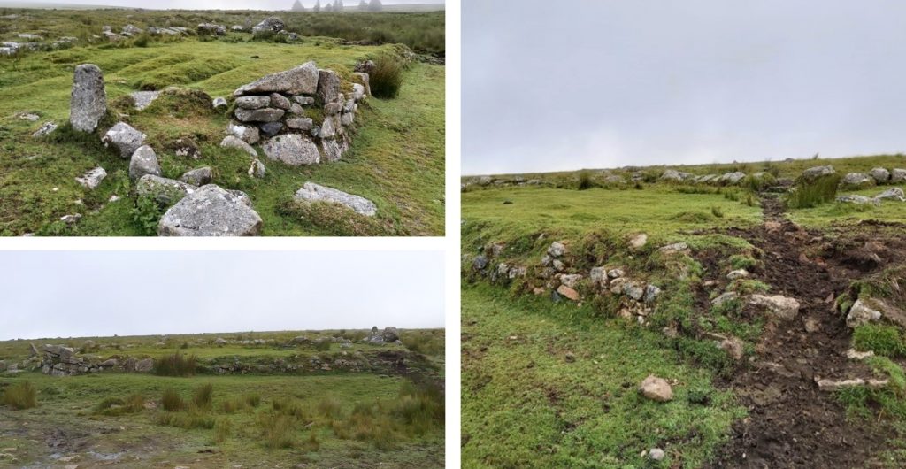
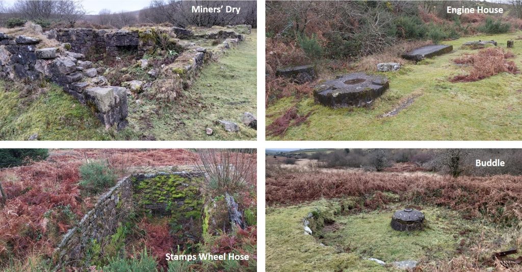
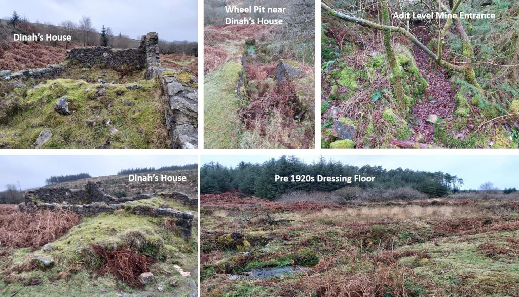
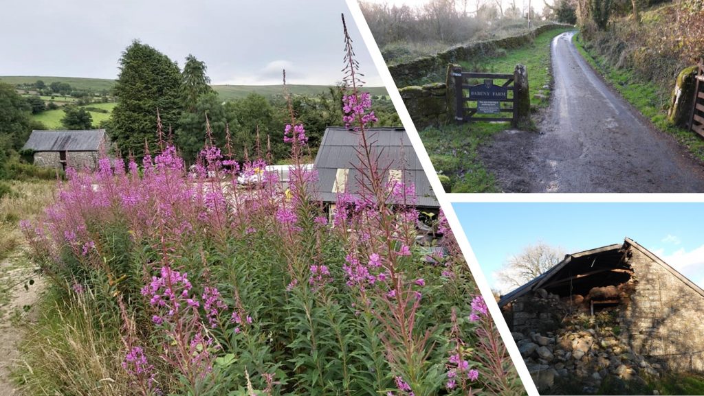
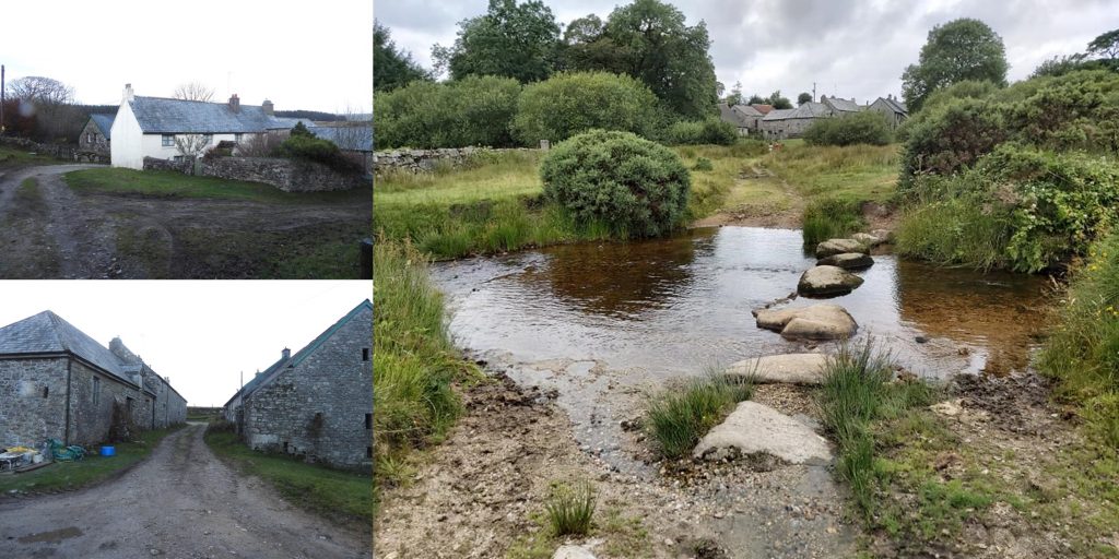
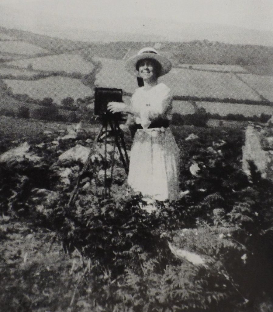
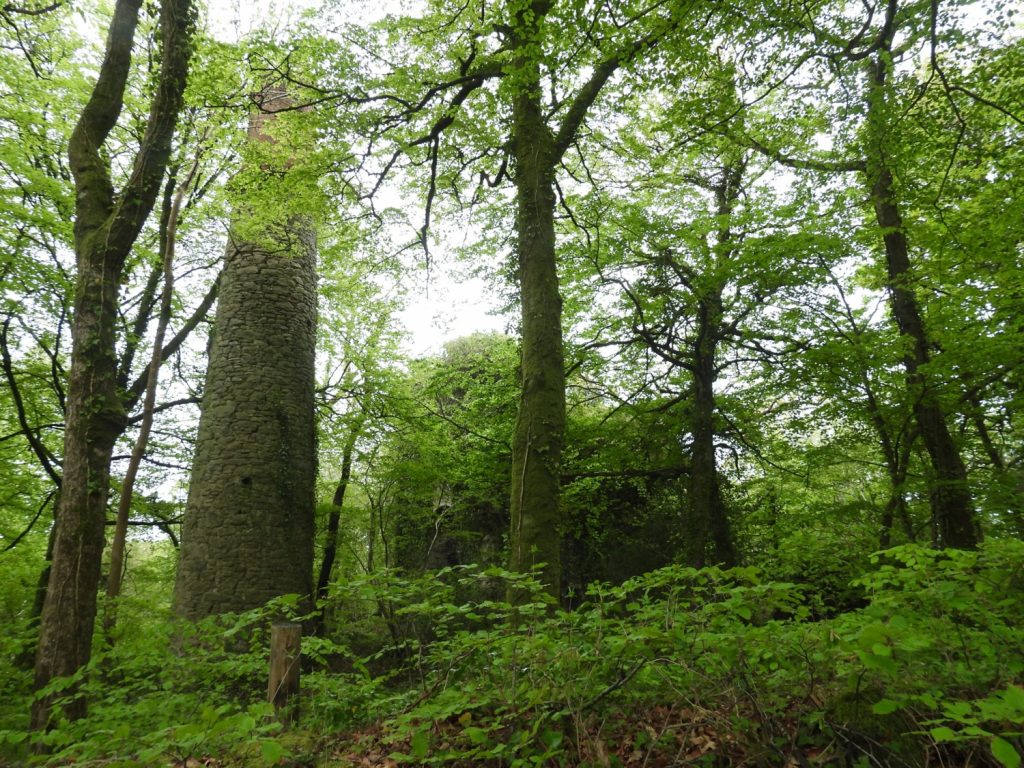
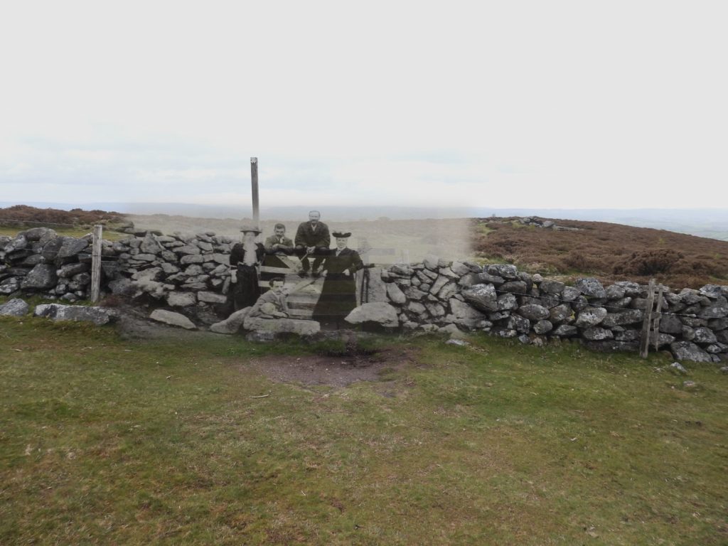
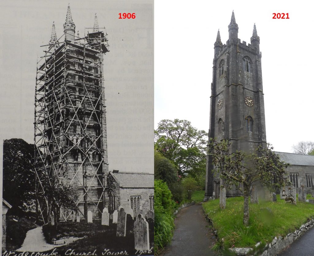
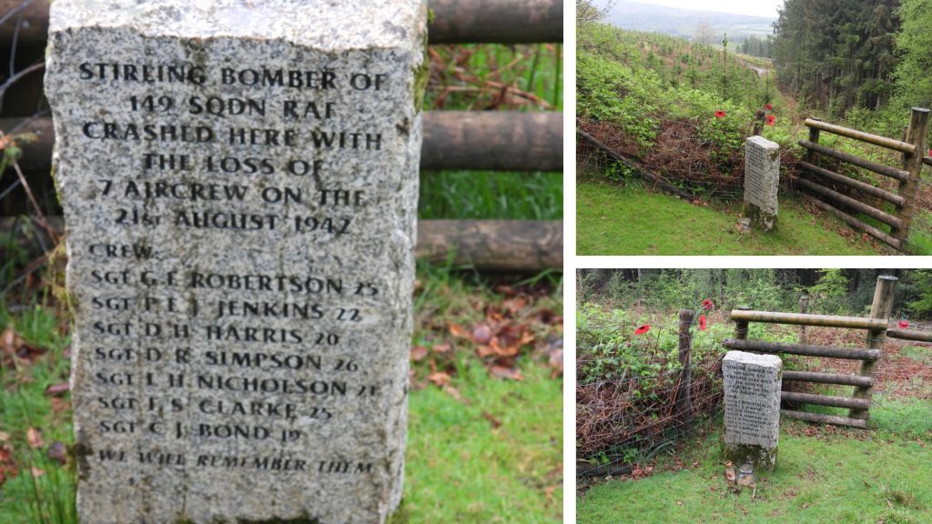
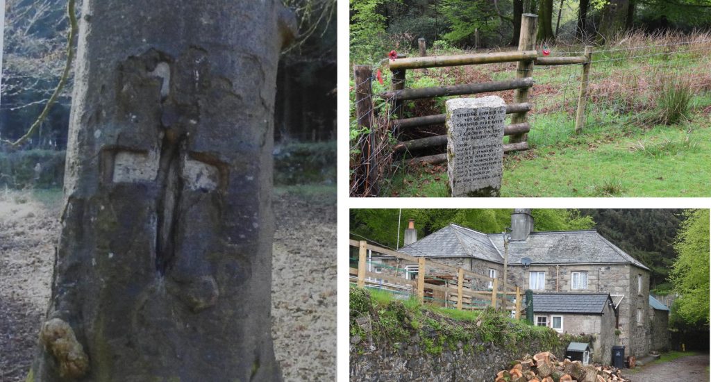
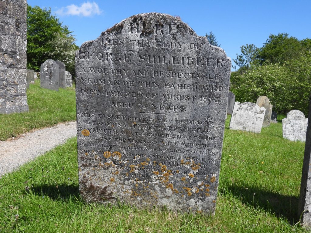
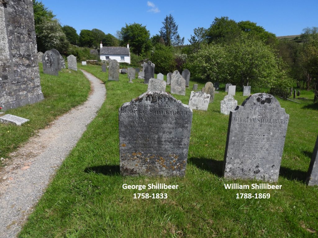
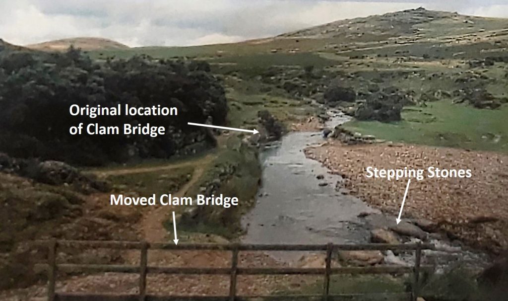
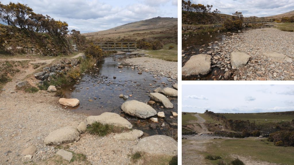
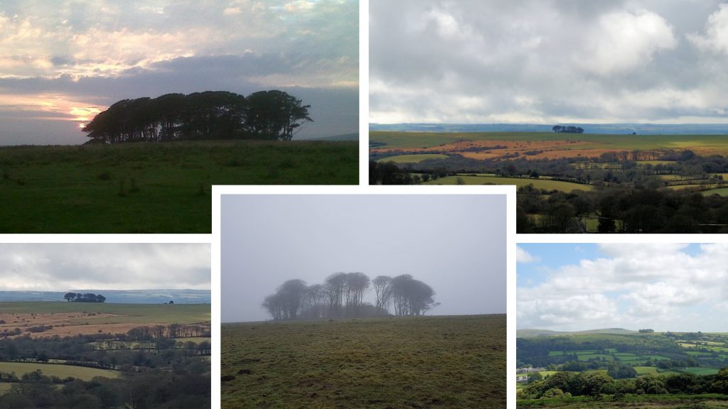
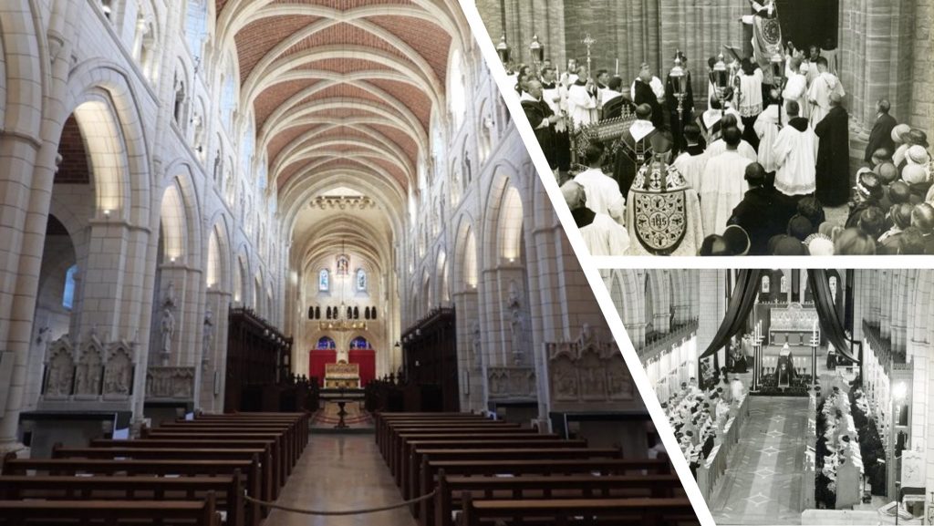
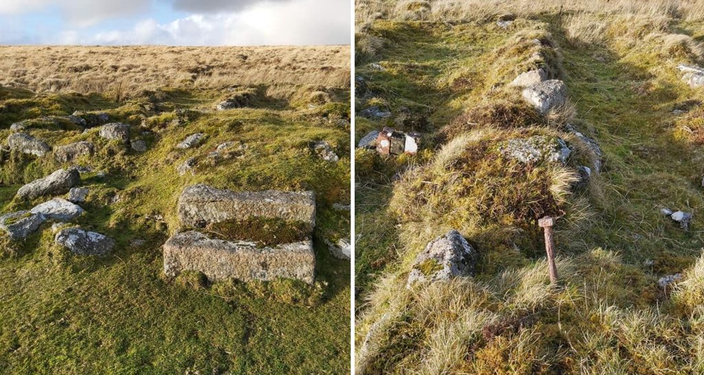
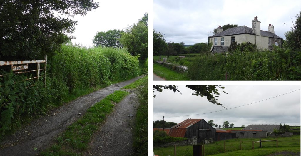
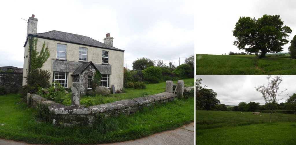
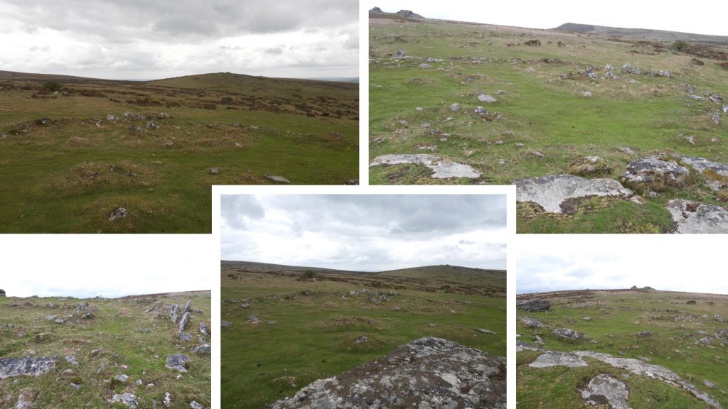
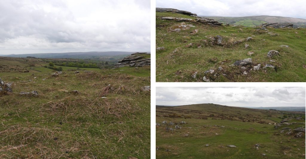
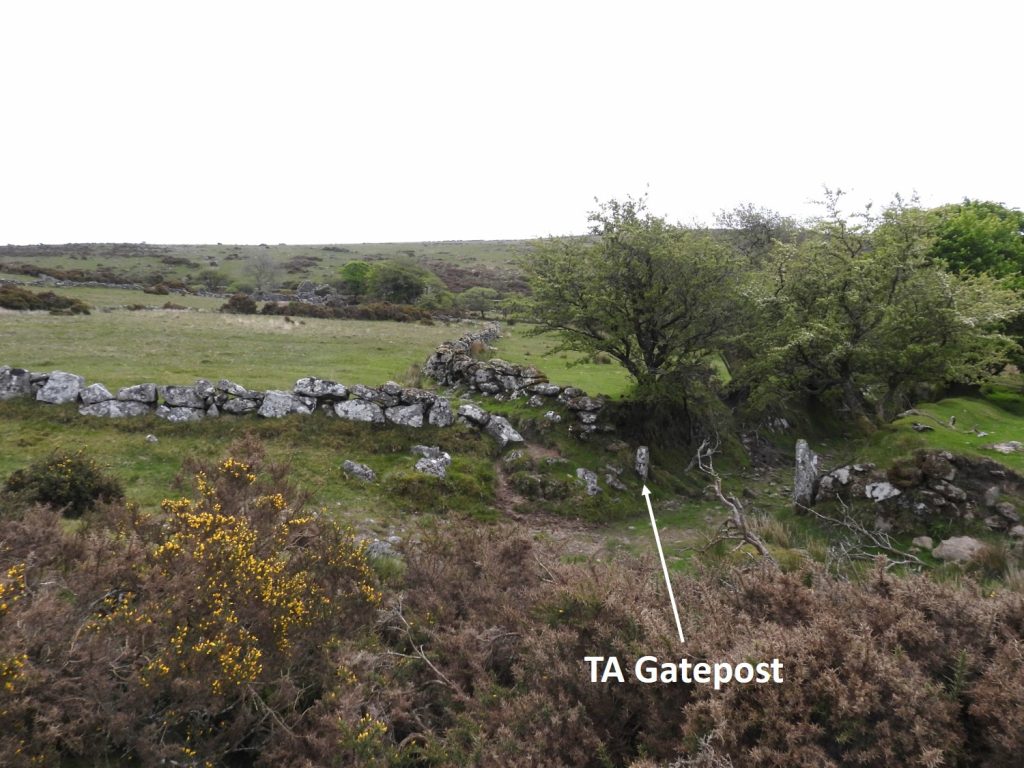
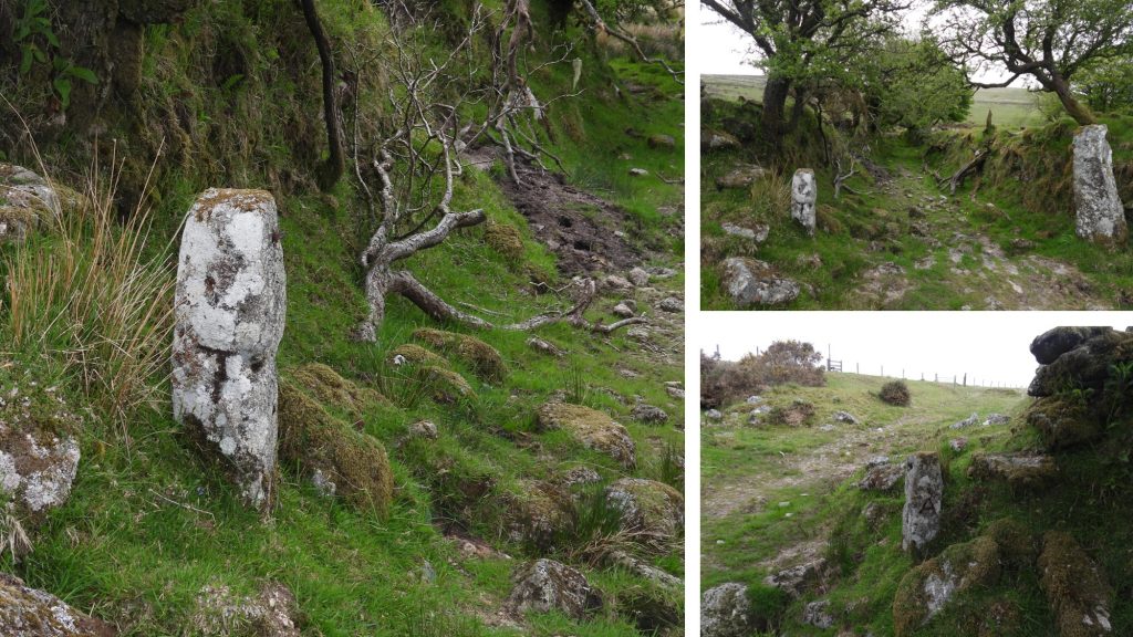
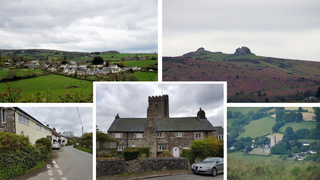
1st August 1898: The Exeter, Teign Valley and Chagford Railway Bill was read for the 3rd time and passed by House of Commons. Royal assent was first given for the formation of the company 4 years earlier on 18th August 1894. The proposal was to connect Exeter with the already extant Teign Valley Railway, the first 10 miles would connect with that line at Lea Cross and from there an 8-mile branch line would terminate at Chagford. The above plan shows the proposal.1st August 1898: The Exeter, Teign Valley and Chagford Railway Bill was read for the 3rd time and passed by House of Commons. Shortly after the creation of the company a Mr Lidstone, Engineer for Dickson’s the Contractors was of the opinion that: “The probability was that the Chagford branch would be opened up before the Exeter side of the line owing to the tunnelling required there. It was important that they should have easy communications with Exeter and this line would bring them within 17 miles of it, whereas now they had to travel 35 miles to it”. Can you imaging a line passing through the Teign Gorge via Dunsford, Steps Bridge, Clifford Bridge and Fingle Bridge !1st August 1898: The Exeter, Teign Valley and Chagford Railway Bill was read for the 3rd time and passed by House of Commons. Discussions with GWR revealed they “were not willing to operate on the Chagford branch of the line, because they argued, they already carried passengers to Chagford via their horse drawn GWR bus service between Moretonhampstead station and Chagford, and they were not prepared to jeopardise that arrangement”. Source: https://www.edgeofthemoor.org/local-history The pictures above what a steam train might have looked like in the Teign Valley. However, in 1898, the Western Morning News reported that the Chagford section was intended to work “……….by means of electricity, the fast-flowing River Teign providing the motive power, and by this arrangement the charming scenery of the Valley will remain unimpaired by smoke and noise of an ordinary locomotive. Negotiations are in progress with the Elieson Electric Motor Company (makers of electric tram cars) which it is confidently believed will result in an Agreement to work the line upon terms favourable with the cost of working by steam, and the novelty of this system will no doubt attract many visitors, creating a large amount of traffic”.1st August 1898: The Exeter, Teign Valley and Chagford Railway Bill was read for the 3rd time and passed by House of Commons. The proposal to abandon the Chagford branch and change the company name to Exeter & District Railway was approved when the cost of the 8 mile branchline was deemed too expensive. It required an Act of Parliament to authorise the abandonment of the Chagford line and to rename the company, both of which were granted. On 30th June 1903, the Exeter section of the line was opened for traffic and worked by the Great Western Railway. Looking at modern OS maps, it appears that this line joined up with the extant line which ran from Heathfield to Christow (via the Spara Bridge area).2nd August 1875: The War Office established a permanent camp at Okehampton. The black and white pictures are all early 20th century (likely pre WW1) of the camp with background tors.2nd August 1875: The War Office established a permanent camp at Okehampton. The 2021 view is taken from the south east near Moorgate Farm.2nd August 1875: The War Office established a permanent camp at Okehampton. Pictures were taken inside the camp in June 2021. An interesting name (Wendy House) at the entrance.3rd August 1887: On this date, there was an official opening ceremony of Great Week Consols Tin Mines. As recorded on the Legendary Dartmoor website: “The mine was bedecked with bunting, flags and evergreenery along with a huge banner at the entrance to the mine stating; “Success to the Great Week Consols Tin Mines.” The official opening ceremony was attended by the directors and shareholders of the mine, the workers and numerous people from Chagford and the surrounding area”. 3rd August 1887: On this date, there was an official opening ceremony of Great Week Consols Tin Mines. Hamilton Jenkin described the openwork thus: “The main stockwork stands a short distance SW of the hamlet of Great Week and is of impressive size being 30 to 40ft deep and approximately 50ft wide. From the bottom of this now tree-lined avenue the ore body was followed down on the northerly underlie in Lydia’s Shaft to a depth of 24 fathoms below the 12 fathom adit, the latter having been driven by the old men through almost the entire length of the sett. A second shaft, 65 yards SW of Lydia’s reached only to adit level.” As can be seen from the previous photograph there was also a tramway running a short distance from Lydia’s shaft. Today (pictures from June 2021), the openworks are bisected by a public footpath, however, the remains of a tramway do not appear extant. In a conversation with the occupant of Great Weeke Farm, the author was told Lydia shaft and the openworks were referred to as the “Goyle”, which is a term meaning ravine.3rd August 1887: On this date, there was an official opening ceremony of Great Week Consols Tin Mines. Also from the Legendary Dartmoor website it was recorded that: “At precisely 1.00pm the machinery was started up and the audience of several hundred people watched the wheel and stamps in operation. At the time it was estimated that between 400 and 500 tons of ore was waiting to be crushed. Having set the mighty wheel in motion Mrs. Basch, a directors wife wished that it would be; “a wheel of fortune; that there would be plenty of water to turn it and plenty of tin to crush.” The directors and their friends were then taken off to a “spacious tent” for lunch after which a clock was presented to Captain Maunder which had the following inscription; “Presented to Captain Maunder by the employees under him at the Great Week Consols Mine 1887.” Today, at Great Weeke Farm (note the added “e” in the name Weeke), there is what appears to be a double stamp granite block (shown to the author, with thanks by the current occupier of the farm).3rd August 1842: George Giles, the Maristow steward, wrote to John Hannaford of Cadworthy, Meavy asking him to “prepare posts to shew the boundary across Wigford Down between Sir Ralph Lopes and Mr Scobell”. He continued: “…..the only working or dressing…would be to merely flatten a space about six inches square on the eastern side of the posts….and in that square to engrave deeply a bold L”. Today there are eight of these posts as shown on the sketch map above. Also in the area, there are also eight stones engraved ‘BA’ which is thought to stand for Buckland Abbey.3rd August 1842: George Giles, the Maristow steward, wrote to John Hannaford of Cadworthy, Meavy asking him to “prepare posts to shew the boundary across Wigford Down between Sir Ralph Lopes and Mr Scobell”. The picture shows L1 (as per the map) which can be found near the main path between Cadover Bridge and The Dewerstone at SX54407 64548. Notably only an “L” is inscribed on these stones for Lopes; Mr (Edwin) Scobell (sometimes spelt Scoble) doesn’t get a mention on these stones!3rd August 1842: George Giles, the Maristow steward, wrote to John Hannaford of Cadworthy, Meavy asking him to “prepare posts to shew the boundary across Wigford Down between Sir Ralph Lopes and Mr Scobell”. 18 months earlier, on 18th February 1841, George Giles, wrote to a land surveyor by the name of William J Stentaford, thus: “I have been with Sir Ralph Lopes & Mr Scobell on Wigford Down this day they both returned to my office…and ultimately agreed on an equal division of the 393a 3r 15p, the boundary to be shown by Granite posts, when the line has been traced — and that Mr Scobell’s portion shall be that moiety next adjoining his inclosed lands of Urgles and Good-a-Meavy beginning north from the corner of outher Diamond park…across towards Oxen Torr — or somewhere in that direction, wherever the line of equal division may fall…the line…must be taken up from Sir Trayton Drake’s boundary of Greenwell Down — and should it fall upon Shaugh Prior Boundary it must not be carried across it…This is a matter that requires your earliest attention. Sir Ralph and Mr Scobell will again meet on the locus in quo when you are prepared to shew the divisional line. This Job is to be at the joint expense of each party.” The pictue shows the last of the eight remaining posts (L8) which is located at SX53421 655954th August 1826: The Dartmeet Clapper Bridge was severely damaged when the East Dart rose to a great height following very heavy rainfall. Source: The Dartmoor Diary 1991 by DNP5th August 1903: William Crossing series entitled ‘Present Day Life on Dartmoor’ first appeared in the Western Morning News. The series was later incorporated into Crossing’s Dartmoor Worker, which was first published in 1966 by David and Charles. Crossing was contracted to write 19 articles, but he added one more to make the round 20. They were published on a Wednesday and started on this date. The 20 topics were: The Farmer, The Moorman, The Labourer, The Newtake Wall Builder, Swaling, Peat Cutting, The Warrener, The Miner, The Quarryman, The Clay Labourer, Whortleberry Gathering, The Sportsman, Under Canvas, The Prison Officer, The Antiquary, The Artist, The Visitor, Coaching, The Guide and ‘In Along’ & ‘Out Auver’.5th August 1903: William Crossing series entitled ‘Present Day Life on Dartmoor’ first appeared in the Western Morning News. On page 61 of Crossing’s Dartmoor Worker, there is a section on ‘Wistman’s Wood Warren’, where he describes rabbits being caught in nets which are 300 feet long. Accompanying the piece is the picture above (top left), which at one time was ‘The Cabin of the Warrener’. The other picture and plan above can be found here: https://dartmoorexplorations.co.uk/wistmans-warren/5th August 1903: William Crossing series entitled ‘Present Day Life on Dartmoor’ first appeared in the Western Morning News. Crossing mentions Teign Head Farm (page 13 of Crossing’s Dartmoor Worker) as ‘lonely in the extreme’. He states that apart from Summer, the farm received no visitors. He further describes the appearance of the foxhounds or harriers were the one thing that would break the monotony of their (the occupants) existence. 5th August 1988: The first edition of the Chagford Times was published. The author believes there were only a few issues published with the first one (front cover in the picture) headlining with the Chagford Parish Map Project which was borne out of a Nationwide scheme promoted by ‘Common Ground’. The Common Ground website states the idea behind a Parish Map was “to demonstrate what people claim as their own locality and what they value in it – wildlife, history, work, landmarks, buildings, people, festivals”. Thanks to Emma Cunis (Dartmoors Daughter) for supplying the front cover picture of the first edition.5th August 1988: The first edition of the Chagford Times was published. When giving some thought to which buildings / features are synonymous with this delightful town, the above collage represents some (but not all) of the authors choices.6th August: “O’er Hill” (Chagford), which is one of the open fields for those holding common grazing rights for cattle, sheep and poultry has its gates unlocked until 6th November. Source : Chagford History Society, more information can be found here: https://www.chagfordlocalhistorysociety.org.uk/commons-4/6th August: “O’er Hill” (Chagford), has its gates unlocked until 6th November. The Chagford History Society website mentions 6th August, but the date on the gate states 4th August (to 4th November). The gate is where the town leat enters the field (which then runs around the edge of it).7th August 1895: On this date the 2nd battalion of the Devonshire Regiment completed day one of a march across Devon on their way to a new station in South Wales. They had marched from Plymouth to Yennadon Down (pictures) where they camped. Source: Legendary Dartmoor website, where it is further stated: “The regiment was under the command of Lieutenant-Colonel D. T. Kinder along with 17 other officers. Eight companies of the regiment were on the march totaling 720 men…….they reached Barnstaple on the 15th where after an overnight stay they were to embark on a steamer heading for Pembroke Dock”. https://www.legendarydartmoor.co.uk/regimental-march.htm7th August 1886: It was recorded on this date that the flow of water at Skaigh waterwheel was 4.5 revs per minute. The waterwheel was part of Belstone Consols and was around 70ft in diameter (just over 21m). It was erected to drain Great Copper Hill Mine sometime around 1878. The wheel pit (wheel house) in which the wheel turned can be found just below Higher Sticklepath (Skaigh Lodge). It is recorded that the wheel was painted bright red and was an “object of such terror to horses that it was almost impossible to ride or drive them past it”. The wheel pit can be located at SX63267 93914.8th August 1528: On this date a 40-year lease of Reddaford (Redford) was granted to Mawtilde Taverner, widow, and her son John. Source: REDDAFORD FARM, WILLSWORTHY, PETER TAVY – an archaeological and historical survey by Tom Greeves, MA, PhD from 20078th August 1528: On this date a 40-year lease of Reddaford (Redford) was granted to Mawtilde Taverner, widow, and her son John. The lease also included Lanehead, (which is next to the car park used by hikers today). The two farms seem frequently to have been linked together and are approx 1km apart.9th August 1961: Member of Dartmoor Rambling Club injured at Lints Tor. The rambler received a serious hand injury, which required hospital treatment, when a piece of rock weighing about a hundredweight fell from the fractured face of Lints Tor.9th August 1961: Member of Dartmoor Rambling Club injured at Lints Tor. The rock which injured the rambler when it fell from the fractured face of the tor had been used by the Army as a target.9th August 1893: Work on Burrator dam was officially commenced. There was a formal ceremony at the site (which had already been partly prepared for the works which were to follow).The picture shows the plaque at the dam commemorating the first build between 1893 and 1898. The dam was raised again in 19289th August 1893: Work on Burrator dam was officially commenced. There was a formal ceremony at the site. The dam was raised again in 19289th August 1893: Work on Burrator dam was officially commenced. There was a formal ceremony at the site. The picture shows the reservoir in January 202410th August 1310: Under the patronage of Bishop Walter Stapledon of Exeter, a fair charter called St. Lawrence’s Feast Day was obtained for Ashburton. Four years later (as indicated by the sign in the picture), the chantry (Chapel of St. Lawrence) was given to Ashburton.11th August 1789: John Andrews became the first known visitor to be guided to Cranmere Pool, which was 65 years before James Perrott placed a bottle there in 1854 for visitors to place their calling cards. Picture 1 is the Prince of Wales being guided to the site in 1921. Picture 2 was taken at the opening of the “new’ cairn on Saturday 8th May 1937 by Ruth E. St Ledger-Gordon. Aubrey Tucker (an ex-tin miner from Sticklepath was commissioned to build the cairn. He obtained the granite for the structure from Belstone Tors. Amongst the guests there were Beatrice Chase. However, Richard Hansford-Worth had declined his invitation. Picture 3 is the site dated from 1905.11th August 1903: South Brent beat the moorland section of their bounds. The map shows boundary markers between South Brent and Ugborough parishes. There is a “natural” boundary rock (at Glaze head) and 15 more boundary markers (including Petre’s Cross). The numbering of the boundstones has been obtained from Dartefacts (for consistency for any would be explorer) and whose labelling origin may have been done by Mark Fenlon or possibly Dave Brewer.11th August 1903: South Brent beat the moorland section of their bounds. The picture is Little Petre BS between Buckland Ford and Western White Barrow. This marker was erected by the Duchy.11th August 1903: South Brent beat the moorland section of their bounds. The location of the Ugborough / South Brent Parish Boundstone, No.10 is interesting insofar as it is labelled Hobajohn’s Cross on 19th Century maps. Hobajon’s (note no “h” in the spelling) Cross is labelled as being located at Piles Hill on modern OS maps (where there is a cross inscribed on an upright stone). An old path called “Blackwood Path”, which lead to Erme Pound, is located to the west of Three Barrows (note that this is before the Redlake Tramway was built).11th August 1903: South Brent beat the moorland section of their bounds. Boundary Rock at Glaze Head. In the Dave Brewer book, Dartmoor Boundary Markers (2002) there is an extract of the South Brent beating the bounds and is dated from 15th August 1903*. It states that the moorland boundary had not been beaten since 1871. The 1903 beating the bounds was attended by approx 100 horsemen and walkers. They gathered on Corringdon Ball Gate with a Mr John Edmonds being the guide and initially followed the Glaze Brook to its Head. *Note: The date of 11th August is recorded in Mike Brown’s Dartmoor 2001 – A Dartmoor Diary of Yesteryear (page 82)11th August 1903: South Brent beat the moorland section of their bounds. The 19th century map shows 14 boundary standing stones between Dockwell Hole and Long-a-Traw which lie between South Brent and Dean parishes. The modern OS map only shows 11 boundary stones. The author has found 15 on this boundary line. More information can be found here: https://dartmoorexplorations.co.uk/south-brent-dean-prior-parish-boundary-standing-stones-between-dockwell-hole-and-long-a-traw/11th August 1903: South Brent beat the moorland section of their bounds. This is the first boundary stone near Dockwell Hole. This view is towards Harbourne Head (and man) looking east11th August 1903: South Brent beat the moorland section of their bounds. Boundary stone 14, near Small Brook foot, where it drops into the Avon12th August 1762: Sir Thomas Tyrwhitt was born. He was elected to Parliament as MP for Okehampton in 1796. He spent the next twenty years working to cultivate and populate the ‘wasteland’ of Dartmoor. Tyrwhitt’s achievements include building several roads across the moor, the creation of Prince’s Town, in honour of the Prince of Wales. He persuaded the government to erect a prison at Prince’s Town (completed in 1809) to house prisoners-of-war captured during the Napoleonic Wars. He was also responsible for the railway line that opened in 1823, which ran from Prince’s Town to Plymouth. In 1812 Tyrwhitt was appointed Gentleman Usher of the Black Rod and received a knighthood. 12th August 1762: Sir Thomas Tyrwhitt was born. There is a memorial to him in St. Michael and All Angels Church on the north wall. The motto on the memorial says ‘me. stante. virebunt’ which translates as ‘While I stand they will flourish‘.13th August 1985: Marchants Cross was re-erected following repairs by the National Parks Authority stone mason. The cross had been severely damaged in November 1984, when it was struck by a trailer. Use was made of Robert Burnard’s pictorial records from 1891 and TDA (Transaction of Devonshire Association) records from 1938 to replace the cross in the correct position. Source: The Dartmoor Diary 1991 by DNP. 13th August 1985: Marchants Cross was re-erected following repairs by the National Parks Authority stone mason. The shaft is 2.43m from the socket stone, which is exactly the same height as before. In the mid-20th century it was supposed that the cross was Smallacumbacrosse mentioned on a Buckland Abbey charter. Its site close to the foot of Smallacombe and its proximity to the ford across the Meavy, convinced William Crossing of this authenticity. 13th August 1850: The South Brent peat and peat charcoal works established at Shipley Bridge was dissolved. It was established by Leyson Hopkin Day and William Wilkins of Totnes. The pictures are the inside and outside of the Naptha Works (extraction from the peat), which became a “thickening” tank, when it was re-purposed in 1872 when used by the Brent Moor Clay Company.13th August 1850: The South Brent peat and peat charcoal works established at Shipley Bridge was dissolved. The pictures are from the Zeal Tor Tramway, which was built to transport the peat from the Red Lake area, some 3 miles from Shipley Bridge. The tramway was horsedrawn and had granite sleepers and wooden rails, where one survives today as can be seen in the photograph.14th August 1910: A severe thunderstorm hit SW Dartmoor and it was observed that at one point the lightning was almost continuous. One observer at Whitchurch counted over 700 flashes in 40 minutes. Source: DNP diary 1991. The pictures are of ponies by the pimple and Whitchurch Down Cross, which was a waymarker used by monks on their journeys to the Tavistock Abbey from both the Buckfast Abbey, via the Monks’ Path and from Plympton Priory.15th August 1941: RAF Harrowbeer was officially opened on this date. intriguingly, the name ‘Harrowbeer’ was chosen in order to distinguish the potential name of RAF Yelverton from the similar-sounding RNAS Yeovilton. The airfield was under the control of No 10 Group RAF but was never assigned a station badge.15th August 1941: RAF Harrowbeer was officially opened on this date. Rubble from the Plymouth blitz was transported to Yelverton to form part of the hard core for the new runways. Also, rock from local quarries was used to form the base for runways and new roads in the area. The shops in Yelverton itself were reduced to single storey buildings to reduce the risk to low flying aircraft. Several roads were diverted and new ones built with a number of properties near to Leg O’ Mutton being demolished. It was at this point, the present roundabout was installed. 15th August 1941: RAF Harrowbeer was officially opened on this date. In 1981, for the fortieth anniversary of the opening of the station, a granite memorial was erected at Harrowbeer, near the Leg of Mutton, as a tribute to all who served there. It reads: RAF Harrowbeer Operational 1941-1949 From this station flew pilots of many Commonwealth and Allied Countries, including Britain, Canada, Czechoslovakia, France, Poland and the United States of America. With the support of their ground crews and Airfield Defence units. This stone is in memory of all those who served here. And especially those who gave their lives. Many local residents helped build and maintain this airfield. Unveiled by the first Station Commander, Group Captain the Honourable E.F.Ward, On the 15th, August 1981, the fortieth anniversary of the opening of the Station.15th August 1941: RAF Harrowbeer was officially opened on this date. The picture shows a air raid shelter, which was (re) opened in July 2011 by the RAF Harrowbeer interest group. It can be found near the Knightstone restaurant / tea room, which was the Control Tower / Watch Office. The dedicated website for the station is worth looking at: http://www.rafharrowbeer.co.uk/15th August 1912: The first service was held in the newly built Peat Cott Chapel. The Chapel closed in 198316th August 1976: Upper Merrivale tin blowing and stamping mills, 750m north of Shillapark first registered on Historic England website. The list entry number is 1020039. The entry states: “The monument includes a tin blowing mill, two stamping mills and dressing floors lying adjacent to the River Walkham. The blowing mill is of drystone construction with the wall standing up to 1.2m high. The interior of the mill measures 11.1m by up to 4.5m and access to it was through a clearly defined doorway in the eastern wall. A mould stone sits next to and north of the doorway. West of the mould stone and adjacent to the western wall of the mill is a stone edged rectangular structure which represents a pit in which tin was probably washed prior to smelting. In the northern part of the building is a recess which would have held the bellows that provided the air blast for the furnace. The bellows were powered by a water wheel sitting in the wheelpit attached to the eastern wall of the mill. The water for the wheel was carried to the site in a leat leading from the River Walkham and stored in a small reservoir immediately above the mill building”.16th August 1976: Upper Merrivale tin blowing and stamping mills, 750m north of Shillapark first registered on Historic England website. The record on the database further states: “The north western stamping mill lies on the site of the later blowing mill and was identified during excavations carried out by the Dartmoor Tin Working Research Group over five seasons from 1991. During this excavation, evidence for a channel leading from a stamps pit below the later furnace was recovered. It was not possible to establish the precise character of the building associated with this mill because the structures in this area had clearly been remodelled when the later blowing mill was constructed. Excavations within the blowing mill revealed a well-preserved furnace, which has since been removed, post holes that had supported the bellows, large numbers of mortar stones, and considerable quantities of slag and ceramic material”.17th August 1930: Edward James (Ted) Hughes was born on this date. He was an English poet, translator, and children’s writer. He was appointed Poet Laureate in 1984 and held the office until his death in 1998. He had moved to North Devon in 1961. Before he died, Ted Hughes requested that a granite stone be engraved with his name and placed at his favourite spot on Dartmoor. In accordance with his wishes, a slab of Dartmoor granite was duly inscribed and sited near the rising of the Taw, East Dart, East Okement and North Teign rivers. The stone was airlifted into place in 2001, following special permission from the landowners, the Duchy of Cornwall. English Nature and the Dartmoor National Park Authority also gave permission.17th August 1917: Extreme flash flooding of Red-a-Ven Brook was observed by R.H. Worth. Source: DNP Dartmoor Diary 199117th August 1917: Extreme flash flooding of East Okement (as well as Red-a-Ven Brook) was observed by R.H. Worth. Source: DNP Dartmoor Diary 199118th August 1967: Dartmoor Mission Hall. A quote from the Tavistock Times on this date stated, “The National Park have always wanted to pull it (the Mission Hall) down. It was in a deplorable condition and was no use to anyone”. The last occupants were Tom Hext and his family when the hall closed in 1940. American soldiers stationed at Foggintor used the chapel for a brief period. Miss Kathleen Hext moved out in December 1966, after her father passed away.18th August 1967: Dartmoor Mission Hall. A quote from the Tavistock Times on this date stated, “The National Park have always wanted to pull it (the Mission Hall) down. The Dartmoor Mission Hall ruins can still be seen (opposite the Yellowmead Track), which was marked as a school on the 1888-1913 OS map. In 1895, there were about 60 children in the area not receiving any schooling, so it was decided that the Dartmoor Mission Hall for undenominational worship, which had been built in 1887 was to be used. The rent was £5 per year. The school at Foggintor (Wesleyan Chapel) was closed at this time. The Mission Hall had a spring and had 3 stone and corrugated iron roofed closets at the back. It was a stone and plastered building with a slate roof. There was also a stone and corrugated iron roof wash house and shed.18th August 2000: The “last of the old men” (tin miner Gilbert Warne) passed away on this date. The term ‘old men’ was the title which miners of the modern era used to describe the tinners of ancient times (source DTRG). Gilbert Warne worked at Golden Dagger and in Tom Greeves book “Tin Mines and Miners of Dartmoor” (a photographic record) can be seen in plate 66 outside Dinah’s House and in plate 69 with a work party whilst repairing a mine leat.18th August 2000: The “last of the old men” (tin miner Gilbert Warne) passed away on this date. His passing was described as “The last fragile link with the tin mining past”. An obituary was published in a DTRG Newsletter.19th August 1807: French Officers, residing on ‘parole’ as prisoners of war, assembled at Cross Tree in Moretonhampstead with their band of music. Source: DNP diary 1991. The tree found at the location today is, of course a relatively new one. The tree at the location in the 19th century was rather large with a fabulous canopy.20th August 1260: Parishioners from the former Lydford Parish petitioned the Bishop of Exon (Exeter). Because of the large distances involved in the former Lydford Parish, the petition to Walter the Bishop of Exon was made and in response with the patrons on this day he ordered that the inhabitants of ‘Balbeny’ (Babeny) and ‘Pushil’ (Pizwell), known as the ‘two villages of the moor’ should resort to ‘Whitcombe’ (Widecombe) church. The pictures are of Babeny Farm.20th August 1260: Parishioners from the former Lydford Parish petitioned the Bishop of Exon (Exeter). Walter, the Bishop of Exon, stated in regard of distance from Lydford that it was ‘eight miles in fair and fifteen miles in foul weather’. For Babeny and Pizwell being able to resort to Widecombe, for such privileges they were instructed that they ‘should pay their tythe lambs and three parts of the offerings to the parson of Whitcombe, and all other tythes to their mother church’. The pictures are of Pizwell Farm.20th August 1881: Miss Amy Satterly, an Ashburton photographer was born. She was born to John and Elizabeth and she grew up initially in North Street then in later life moved to Vealenia Terrace, Ashburton. She tried her hand at being a milliner initially but due to ill health she couldn’t get on with it. It was when she was taught photography (by a James Amery) that her career took off. 20th August 1881: Miss Amy Satterly, an Ashburton photographer was born. She learnt to take photographs (and then develop them) with regular visits to Druid Mine (a small copper mine which had been operational from 1852 to 1872). It can be found just to the north of Ashburton. She met Sabine Baring-Gould on a few occasions at the mine.20th August 1881: Miss Amy Satterly, an Ashburton photographer was born. The picture is one of her portraits of a family on a day out at Buckland Beacon from 1902, which has been superimposed onto a 2021 backdrop. The view is looking towards Welstor with Buckland Beacon behind the camera.20th August 1881: Miss Amy Satterly, an Ashburton photographer was born. The picture is one of her compositions from 1906 of Widecombe Church Tower (St. Pancras) alongside a 2021 composition. 20th August 1842: A Tithe commissioner is appointed in order to resolve a dispute connected with the Teignhead Great Newtake. The commissioner was called James Jerwood and his brief was to “…inquire, ascertain and set out the boundaries abut Dartmoor and other commons”. The timeline of issues lasted over two hundred years and can be summarised thus; a) In the 1608 forest of Dartmoor Perambulation the jurors misinterpreted Wotesbrokelakesfote (Hew / Hugh Lake Foot) as Whoodlake (Walabrook) from the Heigheston (Longstone). Thus the forest boundary in 1608 continued north from the Longstone rather that turning west and must have placed both the Gidleigh and Throwleigh boundaries into some doubt; b) The Gidleigh commoners conducted their own perambulations and a map dating from 1639 reveals that a number of points of reference for their purposes “crept in”. Of note, is that the 1639 Gidleigh map showed their boundary to run in a direct line from Manga Rock to the Thirlstone (Watern Tor); c) In 1791, a House of Commons petition sought authority to enclose large parts of central Dartmoor which resulted in the Duchy granting leases to enclose huge newtakes to enlarge farms. It was as a result of this petition that Teignhead Farm (circa 1808) and its newtake were built. This brought sharply into focus the Gidleigh bounds as the Teignhead Farm enclosures extended far beyond the line of the forest bounds accepted by the commoners of Gidleigh (by around 700 / 800 acres); d) Between the dates of the building of the newtake wall (circa 1808) and the boundary settlement (1843) there had been an interim agreement as to the line of the boundary agreed between the Duchy and Gidleigh. This occurred in 1813 and three new boundstones were erected; e) The Great Teignhead Newtake wall represented a poignant physical barrier which must have caused much controversy with the Commoners. The original wall constructed had to be rebuilt (on a different line and which is the one we see today) as the original one was ‘cast down’ by the commoners. It was the supervisor of the construction of the wall (William Rogers) who was instrumental at the 1842 enquiry and subsequent 1843 settlement when he gave evidence in favour of the Commoners as he stated he (acting on behalf of the Duchy through a Mr Crawford) had built the wall against old Gidleigh ‘G’ marked stones, taken old boundary stones down and used them as foundations in the new wall and had obliterated stones marked with a ‘G’ knocking them out with a pick.20th August 1842: A Tithe commissioner is appointed in order to resolve a dispute connected with the Teignhead Great Newtake. Manga or Mangerford Rails were once on the Duchy / Gidleigh boundary (1813 interim agreement). The granite posts which support these rails have been in place since around 1780.20th August 1842: A Tithe commissioner is appointed in order to resolve a dispute connected with the Teignhead Great Newtake. The 1639 Gidleigh Map previously mentioned in this post, showed the Commoners recorded their boundary as following a direct straight line from Manga Rock to the Thirlstone (Watern Tor). However, in May 1813 after the Teignhead newtake wall had been built, there was a meeting between the Duchy and Gideligh regarding the boundary as the newtake extended into Gidleigh claimed lands. From a Duchy perspective the newtake was within their lands and had been since 1608. The 1813 agreement, appears to have been between the Duchy and only one Gidleigh representative (called Rowe) which culminated in three new boundary stones being erected. The boundary stone in the above picture is the second of three.20th August 1842: A Tithe commissioner is appointed in order to resolve a dispute connected with the Teignhead Great Newtake. This boundary stone is the final one of the trilogy, dating from 1813. It is known as ‘Haydon B.S’ or ‘Headon B.S’ with a ‘G’ inscribed (Gidleigh). The Headon B.S also has ‘DC / TP’ inscribed on its north west side. The ‘DC’ (Duchy of Cornwall) would have been the original inscription on this side with ‘TP’ (Throwleigh Parish) added later. It is assumed, due to the orientation of the stone that it was once recumbent and has been re-erected (incorrectly). It is assumed that the stone originally only had ‘DC’ inscribed on this side with Throwleigh utilising it as one of their stones at a later date. 20th August 1842: A Tithe commissioner is appointed in order to resolve a dispute connected with the Teignhead Great Newtake. Manga Rock is shown on modern OS maps. The picture is a view overlooking Hew (Hugh Lake) towards Hawthorn Clitter. This rock represents the ‘turning point’ of the Duchy / Gidleigh boundary from southeast-northwest to east-west as now agreed. The 1639 Gidleigh map showed the boundary leading to Stone Tor from here crossing the North Teign just to the south of Manga rails. Manga Rock is inscribed with a “GP”20th August 1842: A Tithe commissioner is appointed in order to resolve a dispute connected with the Teignhead Great Newtake. Between Manga Rock and Watern Tor are two inscribed earthfast inscribed rocks, one inscribed ‘GP’ (this one), the other simply ‘G’.20th August 1842: A Tithe commissioner is appointed in order to resolve a dispute connected with the Teignhead Great Newtake. The Thirlstone ‘Thurleston’ is at the north end of Watern Tor. The general belief is that the 1240 perambulators (forest bounds) passed through here. However, there is some debate as to what the 1608 Perambulators and 1609 Survey Court took as “Thurleston” – did they mean Watern Tor ? The Duchy at one point claimed the Whit moor stone (near White Moor Stone circle at Little Hound Tor) was the ‘Thurleston’ (or Thirlstone / Thurlestone).20th August 1842: A Tithe commissioner is appointed in order to resolve a dispute connected with the Teignhead Great Newtake. On the 1639 Gidleigh map and following the 1842/3 enquiry settlement, the Thirlstone has been considered to be on the Duchy (Forest) / Gidleigh Boundary and a ‘GP’ inscription is evident here.21st August 1942: A Short Stirling Bomber crashed at Gibhill Wood near Lutton with the loss of all crew. The mission had taken off from Lakenheath, Suffolk the evening of 20th on a mine laying mission in the Gironde estuary off La Rochelle. On their return it is speculated that in poor visibility they were hit by ‘friendly fire’ over Plymouth. The polished granite memorial was erected in April 2011 and can be located at SX59433 59876. Source of information taken from “Dartmoor Air Crashes” by Robert Jones.21st August 1942: A Short Stirling Bomber crashed at Gibhill Wood near Lutton. The crash site is 200m from Gibhill Cottages (bottom right picture). The RAF recovery team that went to Gibhill Wood carved a simple cross into a tree close to the crash site, a fitting memorial which can still be seen today – see picture on left. The carved cross is on one of the trees in the background of the picture of the granite memorial in the top right picture above but facing in the opposite direction, so cannot be seen directly from the granite memorial.22nd August 1833: George Shillibeer, the first person to be appointed as Superintendent of Plymouth Leat died on this date. He is buried in St Leonards Church, Sheepstor, along with other members of the Shillibeer family.22nd August 1833: George Shillibeer, the first person to be appointed as Superintendent of Plymouth Leat died on this date. His gravestone is engraved: “Here lies the body of GEORGE SHILLIBEER a worthy and respectable yeoman of this parish, who died 22nd of August 1833, aged 75 years. This tablet is erected by the Mayor and Commonality of the Borough of Plymouth as a token of respect to the memory of the deceased who for upwards of the last 40 years of his life had been the faithful and indefatigable agent and superintendent of their water leat and the banks thereof from the Head Weir so far as Jump”. NOTE that Jump is the original name for Roborough.22nd August 1833: George Shillibeer, the first person to be appointed as Superintendent of Plymouth Leat died on this date. Following his death George Shillibeer was succeeded in turn by his son William Shillibeer (1788-1869), Amos Shillibeer (1849-1939), George Shillibeer (1874-1944) and finally William Harold Shillibeer (1882-1948). The grave of William Shillibeer is next to that of George Shillibeer at St. Leonards. William looked after the leat for 36 years after his father.23rd August 2004: The Lydford High Down clam bridge was dislodged after heavy rains. The picture shows the aftermath. Reference: Dartmoor Magazine 77 (Winter 2004).23rd August 2004: The Lydford High Down clam bridge was dislodged after heavy rains. The pictures show a scene of serenity after a long dry period in May 2021. At the time of the heavy rains there was also much devastation further up the river towards the Rattlebrook Peat railway and well as on the railway track itself.24th August 1986: On this date a management agreement was signed and legally concluded to conserve the landscape, ecological and archaeological values of Hanger Down and to give the public the right of access over the Down in perpetuity. Source: The Dartmoor Diary 1991 by DNP25th August 1932: The Abbey Church was consecrated at Buckfast. After 25 years, all but the upper section of the tower had been completed. Cardinal Bourne was chosen by the Pope as his representative. On the designated day there were also five Archbishops, sixteen Bishops, thirty Abbots and many priests. The church was full to capacity and thousands heard the service outside, where loud speakers had been installed. The service was also broadcast by the B.B.C. Source: buckfast.org.uk/history25th August 1557: An inquisition was held at South Brent to enquire about the bounds of Brent Moor (ref: Brown). The result appears to have been that the bounds commissioners were charged with the task of erecting crosses at four specific points on the Brent Moor boundary, namely; at Huntingdon (Western Wella Brook Foot), at Buckland Ford, at Western Whitaburrow and at Three Burrows – afterwards certifying that they had done so and so inscribed the words ‘Bunda de Brentmoor’ upon the last of these (ref: Hemery). In High Dartmoor, Hemery further records that the first three crosses were new and as to the fourth a “ready-made one presented itself within a convenient distance and of no boundary significance, a mere relic of the monkish travellers…” The fourth Cross, to which Hemery was referring was Hobajon’s Cross, not the simple incised cross of the same name seen today, but a granite cross which was near or at the same location incised one which is believed to have been erected by the Buckfast monks as a waymark on their track to Plympton.25th August 1557: An inquisition was held at South Brent to enquire about the bounds of Brent Moor. The map shows the locations of the three new crosses erected in 1557 by the Brent Moor Commissioners; at Huntingdon (Western Wella Brook Foot), at Buckland Ford and at Western Whitaburrow25th August 1557: An inquisition was held at South Brent to enquire about the bounds of Brent Moor. Huntingdon Cross near Western Wella Brook Foot where in enters the River Avon. Starkey measured the cross as being 4.5 feet high (1.4 metres) with the width across arms as 22 inches (0.5 metres). There is a relatively modern dry stone wall, which the author recalls being built. The cross is depicted on modern OS maps. Of interest is the ‘Abbots Way’ is marked as passing the cross. That said, Worth and Hemery considers the ‘Abbot’s Way’ to be a spurious label attached to a southerly trans-Dartmoor route. The name, first occurred in an account by a traveller named John Andrews in 1794, two and a half centuries after the dissolution of the monasteries.25th August 1557: An inquisition was held at South Brent to enquire about the bounds of Brent Moor. Buckland Ford – this is an old film photograph taken in late 1980s / early 1990s 25th August 1557: An inquisition was held at South Brent to enquire about the bounds of Brent Moor. Western Whittaburrow Cairn with the third of the 1557 crosses. The cross is known as Petre’s Cross and was partly destroyed in 1847 by workmen who built themselves a house on the cairn and having knocked off the arms of the cross built it into the fabric of their building to serve as the clavel over the fireplace (ref: Starkey). When the building in the cairn was partially demolished the cross was found. The cross was then re-erected, but this time upside down. The damaged head is buried in the cairn and base of the shaft points skyward. The shaft of the cross also bears a benchmark, cut by Ordnance Survey25th August 1557: An inquisition was held at South Brent to enquire about the bounds of Brent Moor. he fourth and last cross from 1557 was recorded as being at Three Barrows. That said, a 19th century map, shows Hobajohn’s Cross to the N.N.W of the hill. Why would OS place Hobajohn’s Cross here ? Could this map be part of the evidence to place where the fourth cross was located ? Addition to this, John Chudleigh writing in his Dartmoor Antiquities (1892), page 93 records “..another laborious climb over the hill from which Three Barrows with Hobajohn’s Cross may be seen”. Is this the cross Chudleigh was referring ? That said, a mutilated head of a cross was found at Three Barrows cairn over 30 years before Chudleigh’s record.25th August 1557: An inquisition was held at South Brent to enquire about the bounds of Brent Moor. At the location where Hobajohn’s Cross is annotated on the 19th Century Map, there is an unusual circle like cairn. Could this have been the the fourth cross had been erected ? If not, why the circle of stones for a rather non-descript part of the boundary. The location is SX65104 63106. There is what looks like a Boundary Stone here within the circle. This surely couldn’t be part of a cross shaft?25th August 1557: An inquisition was held at South Brent to enquire about the bounds of Brent Moor. Three Barrows Trig Point and summit cairn. The mutilated head of a cross was found in the cairn in 1861, which co-incidently was the year when a army firing range was built on Harford Moor (straddling the stone row to the south of the incised Hobajon’s Cross). The co-incidence is just that, but is quite interesting to note. In 1872, Spence-Bate, when opening up one of the cairns on the hill in 1872, discovered one arm and the top portion of a cross-shaft nearby. Could this be the location of the fourth cross or could the cross have been vandalised from its position to the north and dumped here ? The mutilated cross was last recorded as having been found was 195725th August 1557: An inquisition was held at South Brent to enquire about the bounds of Brent Moor. Hobajon’s Cross, also known as Hoppyjon. Hemery records that John Andrews (and five companions) found this prostrate in September 1800 and re-set it. Hemery suggests this rock is set in a socket stone. This Hobajon’s Cross is supposedly close to where an original cross was located and moved to become the fourth stone in the 1557 boundary at Three Barrows. Jeremy Butler speculates that this stone may have been an original termination of the Butterdon Hill stone row. There are certainly lots of theories and unanswered questions relating the Hobajohn’s / Hobajon’s in this part of the national park. 26th August 1963: Two tank turrets, weighing nearly 15 tons, were towed away from the old Hensroost tin mine. Source: The Dartmoor Diary 1991 by DNP. The series of pictures are the foundations of mine captains house, mine office, miners dry, dormitory and blacksmith shop next to Down Ridge track. SX65656 7110626th August 1963: Two tank turrets, weighing nearly 15 tons, were towed away from the old Hensroost tin mine. The pictures of the ruin (with steps) at SX65731 71179, is the Iron House. It was wood covered and covered in galvanised iron. Some miners slept here and had their meals. The carpenters shop was just a few 10’s of metres away at SX6570 7113 (not in pictures).27th August 1940: A Dornier Do17P photo reconnaissance aircraft crashed at Hurdwick Farm, near Tavistock. The aircraft (nicknamed the “Flying Pencil” because of its slim fuselage) had been identified 100 miles before it reached Plymouth by an operator at RAF Hawks Tor, where a Chain Home system (a forerunner to radar) was located. It was shot down by two Hurricanes (from St. Eval, Padstow), who had been scrambled to intercept it. The three crew survived. Source: Dartmoor Air Crashes – Aircraft lost in World War Two by Robert Jones27th August 1940: A Dornier Do17P photo reconnaissance aircraft crashed at Hurdwick Farm, near Tavistock. Ted Kerswill, a builder was first on the scene. He noted the three crew were injured, battered and bloodied and in need of help. He took a pistol off the pilot and led the three to the farmhouse, where Mrs Bickle (the farmers wife) made them tea, whilst they waited for the police to arrive from Tavistock. As a postscript, ‘Mindy’ Blake the Hurricane leader, turned up at the farm not once but twice to view his marksmanship. The German crew remained as POWs for the rest of the war.28th August 1886: Robert Burnard and David Roy tested the depth of ‘Clazenwell Pool’ (Crazywell Pool). It was allegedly bottomless and using an elaborate combination of a stout clothes line, two timber uprights, a block carry and a deep sea weighted with a leaden sinker of four and a half pounds (just over 2kg). Over 40 ‘soundings’ were made and the greatest depth obtained in this old mine working were between 15 and 20 feet (4.6m – 6m). Source: The Dartmoor Diary 1991 by DNP.28th August 1858: Hill Bridge Mine closed and a vast array of equipment was offered for sale including “an excellent water wheel with an iron axle and rim, 42ft in diameter and 6ft abreast of first rate construction and material” (ref: Mike Brown). Thanks to Dartmoor Chris for providing historical facts about the mine.28th August 1858: Hill Bridge Mine closed. The picture is the Hill Bridge mine wheel house on North side of bridge. The mine was known at some point as Wheal Saturday (circa 1807) but that was well before the wheel.house was built (circa October 1852).28th August 1858: Hill Bridge Mine closed. The wheel house is a fabulous construction but appeared to be operative for barely 6 years (1852 to 1858). The mine was known as Hill Bridge Consols around 1817 and North Wheal Friendship by 1847.28th August 1858: Hill Bridge Mine closed. Hill Bridge mine was also known as Hilltown mine by 185228th August 1858: Hill Bridge Mine closed. Hill Bridge Mine paid damages to John Reep at Hilltown farm for land damages 1852-328th August 1858: Hill Bridge Mine closed. Location of the wheel house shown on 19th century map. This is still shown on modern OS maps29th August 1956: A Burial chamber on Blackslade Down was first registered on the Historic England database. The registration number is 1003285. On the database the description starts thus: ‘This monument includes a round cairn and cist situated on Blackslade Down overlooking the valley of the East Webburn River. The cairn survives as a circular stony mound up to 10m in diameter and 0.5m high with a 6.5m diameter stone kerb and part of a second kerb close to the edge of the mound. Within the mound is a rectangular stone lined cist measuring 1m long, 0.7m wide and 0.4m deep, with no capstone’.29th August 1956: A Burial chamber on Blackslade Down was first registered on the Historic England database. The description on the database concludes: ‘The interior was examined in 1871 by the Parson of Widecombe who found some charcoal and a few fragments of pottery. A low spread mound to the north and east represents spoil removed during the excavation.’ It can be located at SX73409 7550829th August 1956: Hut circle at Tunhill Rocks was first registered on the Historic England database. It is marked as ‘homestead’ on the modern OS Map. The registration number is 1003286. On the database the description starts thus: ‘This monument includes two enclosed stone hut circles situated on the eastern side of Tunhill Rocks, overlooking the valley of the East Webburn River and forming part of the Rippon Tor coaxial field system. The settlement survives as a D-shaped enclosure measuring 26m long by 20m wide defined by stone and earth banks abutting Tunhill Rocks and part of a reave. Within the enclosure are two stone hut circles. The eastern hut circle survives as a double orthostatic wall surrounding a circular internal area. The interior measures 7m in diameter and is defined by a wall standing up to 1.5m wide and 0.5m high. The western hut circle is rectangular in plan and measures up to 3m long by 2m wide internally. It is defined by a rubble coursed wall measuring up to 0.7m wide’. 29th August 1956: Hut circle at Tunhill Rocks was first registered on the Historic England database. The description on the database concludes: ‘Both hut circles were excavated in 1896 and this revealed both to have south facing doorways. Finds included parts of a thick walled decorated and much used cooking pot, a drinking vessel, a flint scraper and flakes, charcoal and a piece of slate’.30th August 1995: TA stone re-erected by DNPA on this date. (Source: Dartmoor Magazine issue 44, Autumn 1996). This gatepost was formerly used to mark old packhorse track over the moor from Tavistock to Ashburton. It is inscribed with letter T on one face and with letter A on opposite face. The stone was first erected in 1699. John Bishops House (aka Lower Swincombe Farm) can also be seen in this photograph.30th August 1995: TA stone re-erected by DNPA on this date. Close up of the TA gatepost. “T” on the north face and “A” on the south side. It can be located at SX63987 7251031st August 1963: The Tor Bus Company , a family run company ceased to operate after 45 years. The reason was blamed on the increasing number of private motor cars which made the service uneconomical. The service ran between Widecombe-in-the-Moor (bottom right), Hay Tor (top right), Liverton (bottom left is old Liverton), Ilsington (middle and top left) and Newton Abbot.