A collection of walks, discoveries, insights and pictures of exploring Dartmoor National Park
January 19, 2026
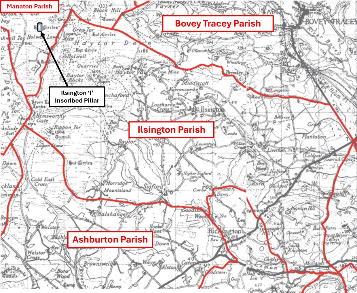
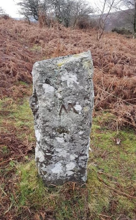
Mystery Inscribed Pillar (Ɨ) on the boundary of Holwell Lawn and Houndtor Down possibly denoting a manor or parish boundary dispute or ‘land grab’
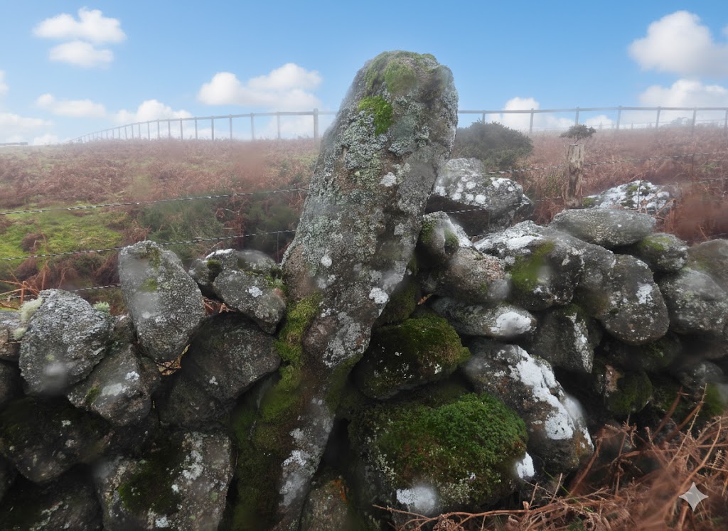
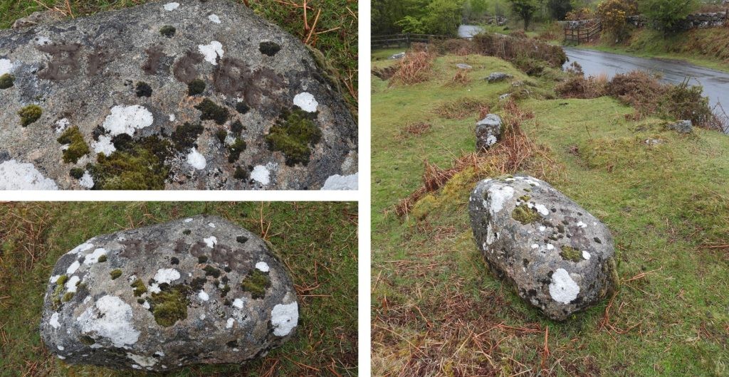
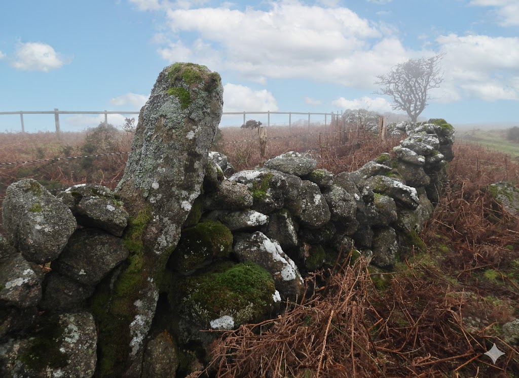
At the northern end of Holwell Lawn, a few hundred metres south west of Greator Rocks and slightly further but south from Hound Tor, set into a drystone wall is a granite pillar about 1.6m tall, inscribed with a capital ‘I’ (with serifs at the top and bottom with a central cross-bar) on its northern face. What is unusual about this pillar is that the inscribed ‘Ɨ‘, which almost certainly denotes ‘Ilsington’, is located well inside the parish of Manaton and not within the known 19th century bounds of Ilsington Manor or indeed the known bounds of Ilsington Parish
Dave Brewer, in the Ilsington Parish section of his fabulous Dartmoor Boundary Markers book (page 102) writes: “It is built into the northern wall of Holwell Lawn facing Greator Rocks…… and about 6ft tall. According to Mr Whitley of Holwell farm, little work has been done on this wall since 1902 when Lord Justice Eve did extensive repair work to it, but of course the uncompleted bondstone may have been there long before that.” He further suggests that the pillar was a spare stone cut in 1835 suggesting it had been intended to for use on the boundary of Ilsington Manor.
It is intriguing to consider that an inscribed pillar of such a size was a ‘spare’ and was not deliberately erected in this location for a well intended or possibly nefarious reasons. The author suspects that the pillar was possibly deliberately placed at this location as a ‘land grab’ by the Manor of Ilsington in the 16th or most likely 17th century. The author has considered a number of pieces of evidence to support this theory, some are quite compelling, others may be pure conjecture to support the narrative.
The author is grateful to Mark Fenlon (regular contributor to articles on boundary markers for the Dartmoor News), who whilst conducting his own research on the nearby Widecombe Town Manor bounds, shared his thoughts on this boundary pillar and others in the immediate locale.
Bibliography
Dave Brewer – (2002) – Dartmoor Boundary Markers (2nd Edition)
Mike Brown – (1993) – Gazetteer of Dartmoor Names
Phil Newman, Simon Probert, H.Riley – (1994/1995) – Houndtor Down, Manaton, Devon – A New Survey by the Royal Commission on the Historical Monuments of England.
Mark Fenlon – Pers. Conv.
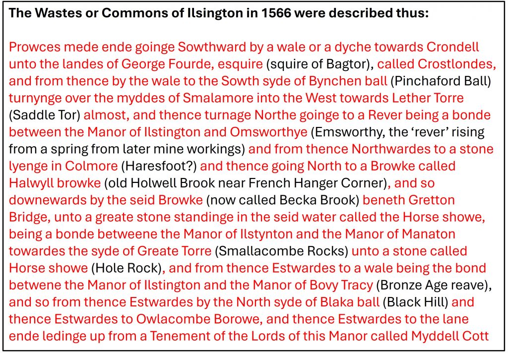
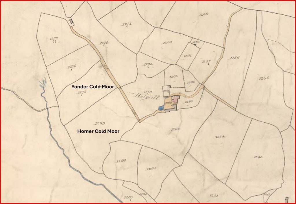
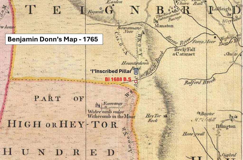
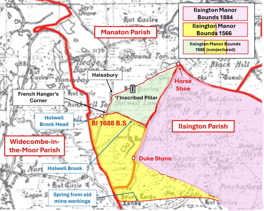
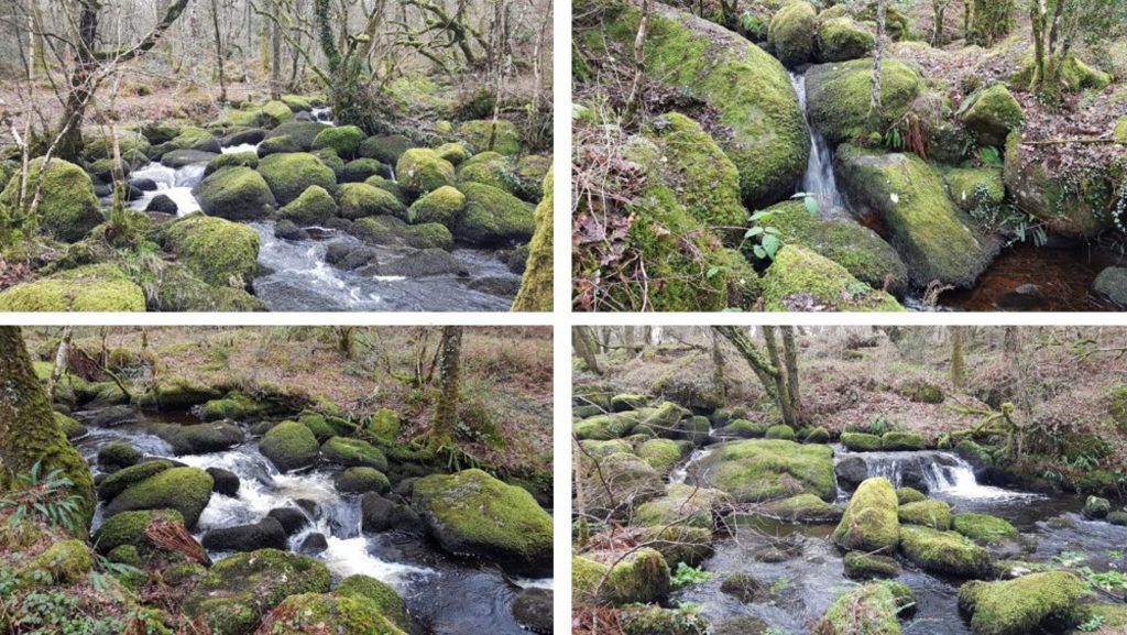
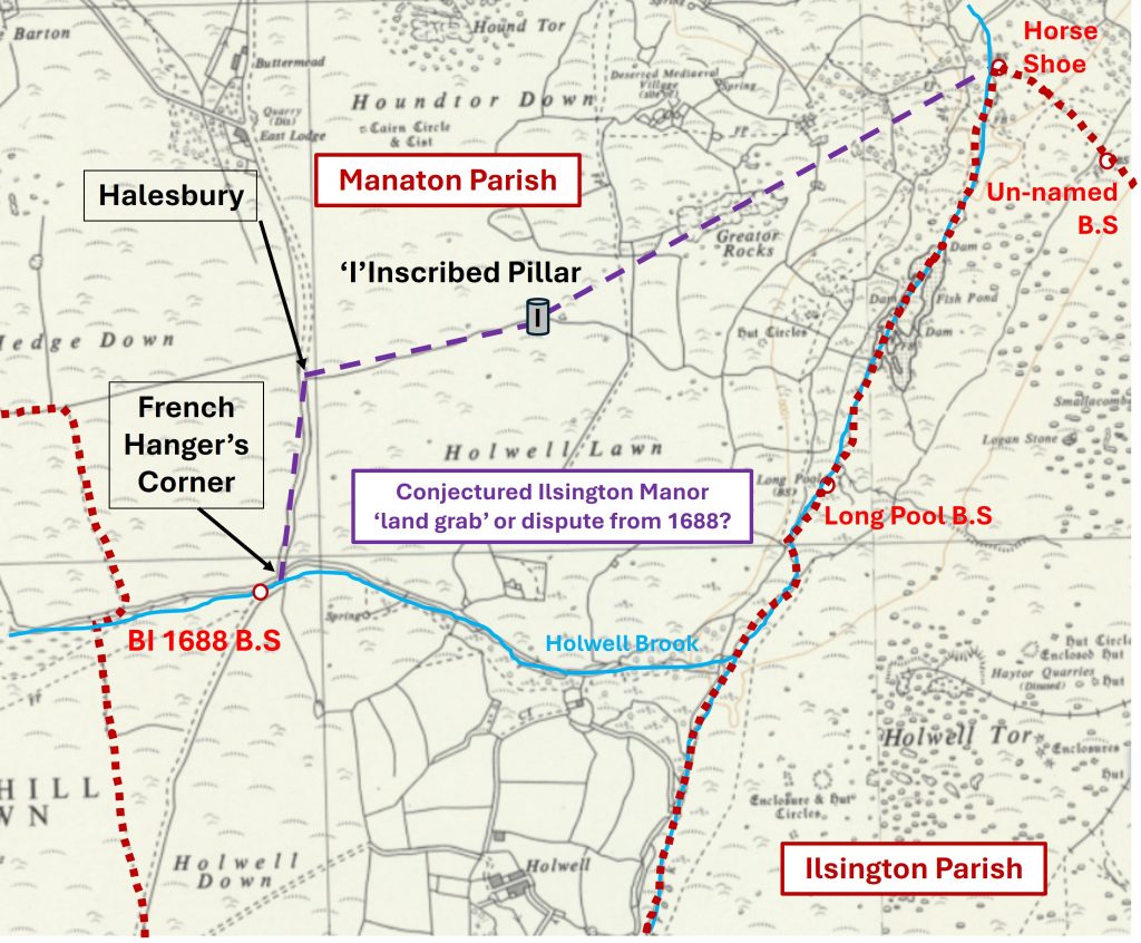
This 19th century annotated map of the Ilsington parish and part Manaton parish shows the location of the inscribed ‘mystery’ pillar. It is interesting to note the pillar sits near the top end of a ‘V’ shaped wedge of the Manaton parishThe ‘Ɨ‘ inscribed pillar lies on the northern boundary of Holwell Lawn at SX74377 78419. It is 1.6 metres high, 0.3 metres wide and 0.25 metres thick (ref: Newman / Probert / Riley). What is interesting is that the drystone wall is little over half the height of the pillar, which itself is leaning to the west side. The author suggests that the pillar may have been originally located here before the wall was built purely based on the mis-match in the heights. The pillar also does not show any signs of ‘tare and feather’ markings, so probably pre-dates 1800. Of note, is that all inscribed pillars and rocks with ‘Ɨ‘ in this area, no matter their known date (17th, 18th or 19th centuries) are all of the same style.In 1566, Ilsingston was one of the estates belonging to a Lord Dynham. There was a comprehensive survey conducted at this time (as recorded by Brewer, page 90) which is shown above. This piece of evidence does provide some suggestion that the Ilsington Manor of the 16th century extended to the west of the now named Becka Brook into the now known Manaton Parish boundary. If the location of ‘Colmore’ could be 100% identified then this aforementioned statement could be stated with some conviction. Brewer suggested that Colmore was possibly ‘Haresfoot’The author turned to the 19th century tithe maps of Manaton, Widecombe and Ilsington to see if the name ‘Colmore’ was mentioned. Tantalisingly, on the Manaton tithe, two adjacent fields of Holwell had the name ‘Cold Moor’ in their titles. Could the name ‘Cold Moor’ be a derivation of ‘Colemore’. This may be the author just speculating to support the narrative. If there is some credence here, then the original 16th century (1566) boundary of Ilsington Manor would have been west of the modern Becka Brook.To support the narrative that the 1566 boundary of Ilsington Manor extended further west than that recorded in the 19th century it is worth considering Benajamin Donn’s map from 1765. Donn’s map shows Holwell Brook (modern Becka Brook) had its headwaters to the west of the Widecombe / Manaton road. This is an important fact as the 1566 survey mentions Halwyll Browke (Holwell Brook). Also, of note is that there is an earth bound rock inscribed ‘BI 1688’ near the headwaters of the brook and just west of the road. The assumption is that ‘BI’ stands for Boundary of Ilsington (or possibly Bag Tor / Ilsington) and the date 1688. Also, of note is that the head of Holwell Brook is located on what was the boundary of the former ‘High or Hey-Tor Hundred’. This earth bound rock is inscribed ‘BI 1688’. It is near the headwaters of the (former) Holwell Brook and just west of the road. It is located at SX73882 77922. It is highly probable that this on the former Ilsington Manor boundary, which was possibly was just re-affirming the 1566 survey. Of course, it might have been an extension of the 1566 survey. The author suspects this boundary marker should be considered in conjunction with the ‘Ɨ‘ pillar on Holwell LawnThis annotated 19th century parish map shows the location of the ‘BI 1688’ boundary stone and the ‘Ɨ‘ pillar on Holwell Lawn. The purple 1884 Ilsington Manor Bounds is 100% known as was drawn by John Chudleigh (Brewer, page 92). The yellow / purple boundary is the authors conjectured boundary of the 1566 Ilsington Manor Bounds based on the evidence of the survey, Donn’s map et. al. Finally the yellow / purple / green boundary is the authors conjectured boundary from 1688 of the Ilsington Manor Bounds – it includes both the ‘BI 1688’ boundary stone and the ‘Ɨ‘ pillar. The line for the latter has been drawn from Halesbury (ref; Mike Brown Gazetteer) as it is mentioned on the Widecombe Town Manor boundary records. Of course, if the Holwell Lawn pillar has been moved then some of the theories, which seem very plausible to me, would be rendered redundant. The Duke Stone at SX74523 77192. In 1853, a stone was erected near here ‘to the memory of the present Lord-of the Manor’, the Most Noble Edward Adolphus, the Duke of Somerset K.G’. The original stone went missing in 1938, thought to have been washed away by floods. The original stone was on a 1879 list of boundstones and was drawn on the 1884 (Chudleigh) map. The current stone (in photographs) was erected in memory of F.H (Harry) Starkey who died in 1989. Harry was a well known author and lived in IlsingtonLocation of the Horse Shoe Boundary marker which when surveyed in 1566 was described as the ‘Greate stone standinge in the seid water called the Horse showe’. Intriguingly, the stone is still shown on modern OS maps, but is considered by most as being unidentifiable since the great flood of 4th August 1938Annotated 19th century map showing the boundary stones / markers in the immediate environs of Becka Brook and the former Holwell Brook. Of note, which might be just pure co-incidence is that a straight line between the ‘Ɨ‘ pillar and the Horse Shoe boundary marker runs through Greator Rocks, is this significant?
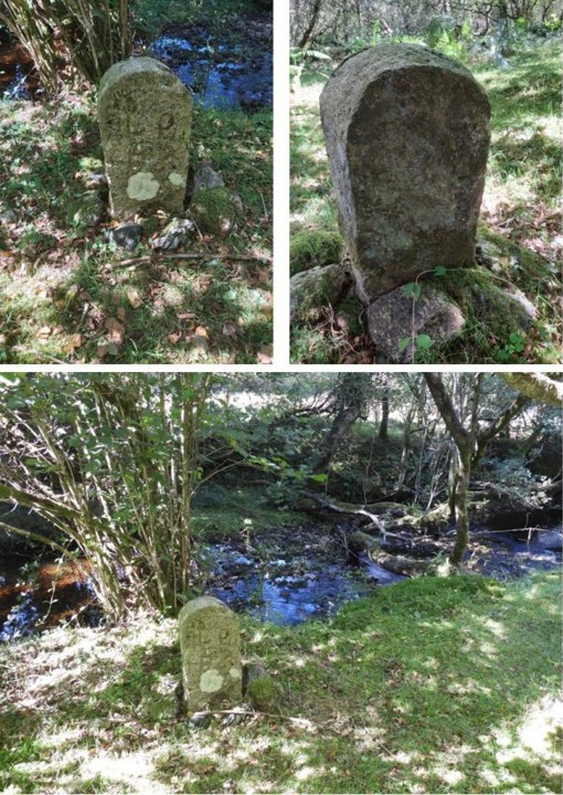
The un-named BS at SX75421 78645. This stone is not mentioned on the 1835 or 1853 survey
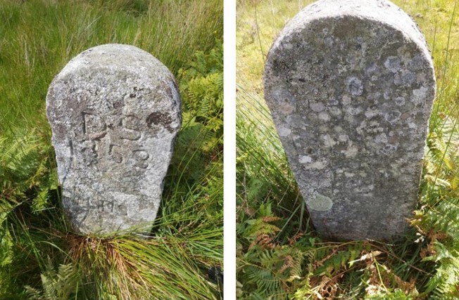
The ‘Long Pool B.S’ at SX74929 78116, next to Becka Brook (former Holwell Brook). It is inscribed LP/DS/DS, albeit this is quite faint. It was named on the 1853 survey
Back to the ‘Ɨ‘ pillar. If any reader of this post visits this location and considers the evidence / information contained herein as to why it is there, the author would be interested to here from anyone who can add to or indeed clarify the mystery.